
The eruptive plume from Eyjafjallajökull taken Holsvelli webcam. Image courtesy of Mattias Larsson.
Sorry to disappoint everyone visiting to blog while they sit at any number of airports around the world, but the eruption at Eyjafjallajökull appears to still be going strong. The Icelandic Met Office is heading up to the volcano to conduct a survey of the crater area to find out (1) what it looks like and (2) how much new water (i.e., ice) is there available for the erupting magma. More water is likely to mean more explosive eruptions in this phreatoplinian style - however, like I mentioned yesterday, the bulk andesitic composition of the ash implies it might have a decent ability to produce explosive eruptions without a lot of extra water (but it helps). You can see a great sequence of images from the eruption on this video (although the music might not be the most fitting). It shows the "puffing" nature of the eruption, which might imply periods of melt water getting into the conduit and flashing to steam (very loosely like a geyser behaves). The Icelandic Met Office continues to have excellent information on the ash and the flooding, which has been somewhat forgotten in the news. There has been extensive flooding around the volcano due to the melting ice.
The flight distruptions around Europe continue, now spreading south across most of Germany and into Italy - in all 23 European nations have total or partial flight bans. However, the ash continues to fall across England, so only limited flights are being permitted. The ash right now is estimated to be costing the airline industry $200 million dollars per day and even causing disappointment to fans of running and music. Remember, ash can destroy jet engines, as happened this week to an Finnish F/A-18 that flew into the ash - and this ash was so dilute in the air that it went unnoticed. The pictures of the damage to the engine are quite impressive. The latest ash dispersal models from the London VAAC have the ash spreading over most of northern and central Europe into Russia as the weekend progresses. The ash in Iceland itself is especially impressive as well, turning day-to-night under the main plume.
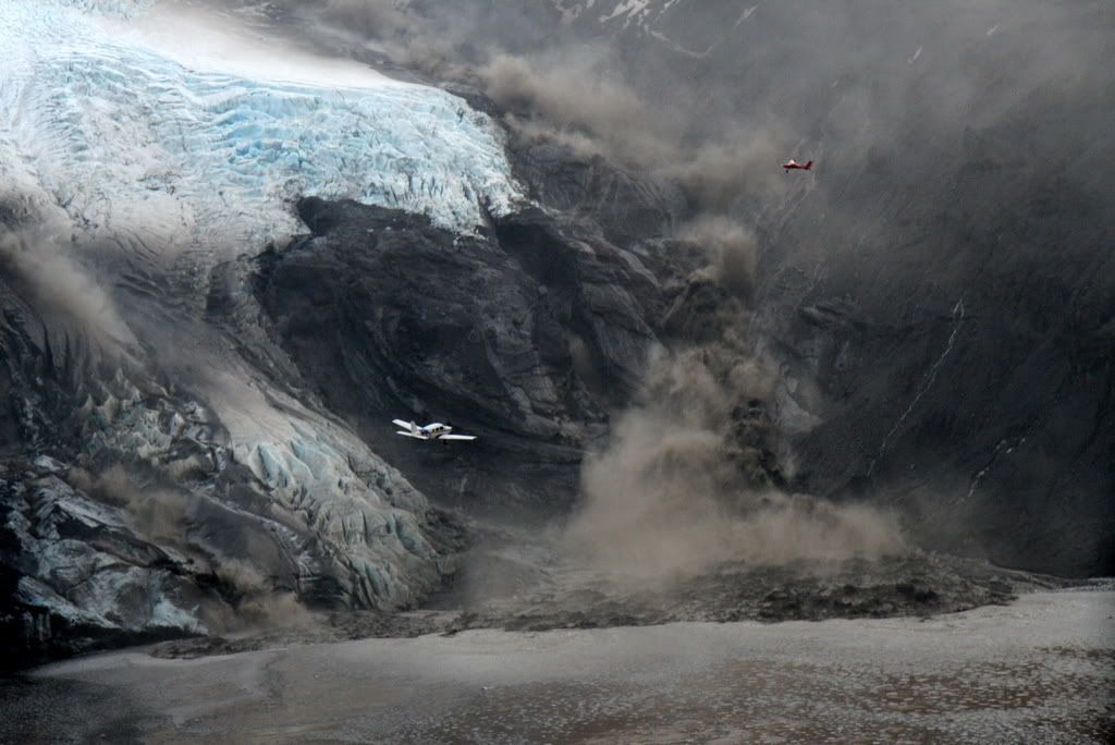
Daring pilots approaching the melting glacier near Eyjafjallajökull eruption. Torrents of meltwater can be seen in the background from the melting glacier.
Eruptions readers have collected quite a bounty of excellent images from the eruption (thank you all!), so here are links to some image collections. Be sure to check out some stunning images of the eruption and lightning in the ash plume at night taken by Marco Fulle over at Stromboli Online. As usual, be sure to check out the webcams available near the volcano.
UPDATE 1: Here is a recap of the explosive phase of the Eyjafjallajökull eruption from the Nordic Volcanological Centre:
Explosive eruptive phase of the Eyjafjallajökull volcano, Iceland, begins
14 April 2010The eruption plume from Iceland that has caused the unprecedented
catastrophic disruption of air traffic and closure of airspaces over
northern Europe is due to an explosive eruptive phase that began at the
Eyjafjallajökull volcano on April 14. It is a continuation of eruptive
activity in the Eyjafjallajökull volcanic system that began 20 March 2010.
During an initial eruptive phase from 20 March to 12 April lava flowed
from eruptive vents on the volcano flanks, outside its ice cover. The lava
erupted in the initial phase is alkali-olivine basalt, with silica content
of about 47%.After a short hiatus in eruptive activity a new set of craters opened up
in early morning of 14 April under the volcano's ice covered central
summit caldera. This eruptive phase was preceded with a swarm of
earthquakes from around 23:00 on 13 April to 1:00 on 14 April. The
earthquake swarm was followed by the onset of seismic eruption tremor.
Meltwater started to emanate from the ice cap around 7 o'clock on April 14
and eruption plume was observed in the early morning. Visual observations
were limited by cloud cover over the volcano, but an airplane of the
Iceland coast Guard imaged with eruptive crates with radar instrument.
Series of vents along a 2 km long north-south oriented fissure were
active, with meltwater flowing down northern slopes of the volcano, but
also to the south. Ash loaded eruption plume rose to more than 8 km
height, deflected to the east by westerly winds.Jokulhlaups (floods of meltwater) reached the lowlands around the volcano
with peak flow around noon on April 14, with destruction of roads,
infrastructure, and farmlands. No fatalities as people had been evacuated
from hazardous areas. Tephra fall begins in southeast Iceland. A second
jokulhlaup/lahar emanates from the ice cap down the Markarfljot valley in
the evening.On 15 April the eruption plume reaches mainland Europe with closure of
airspace over large part of Northern Europe. Activity continues at a
similar level with ash generation and flow of meltwater in pulses.
Jokulhlaup/lahar occurs in the evening. On April 16 some variability
occurs in seismic tremor and tephra generation, but overall the eruptive
activity remains stable. Pulsating eruptive plume reaches above 8 km, with
overall height of 5 km. Large closures of airspace continue.Chemical analyses of ash samples reveal fluorine rich intermediate
eruptive products with silica content of 58%, more evolved than in the
initial lava producing phase of the eruptive activity. The magma
composition may reflect evolution from alkali-olivine basalt by crystal
fractionation as erupted in the initial phase.
UPDATE 2: And here is a site set with all sorts of remote sensing data on the eruption, put together for IAVCEI by Simon Carn.
- Log in to post comments
I've been quiet interested in volcanoes the last year, and i have to say that it's some amazing pictures from Iceland. Hope everything goes well for them up there.
/Pete
I'd appreciate some in-depth speculation on the possiblity of Katla going off. Is there any seismic activity worth worrying about? My buddies in Europe are concerned over the historical connection.
I would love to see some recent pictures of vent area, as well as get that web cam to pan right .... oh well
@Volcanophile #416, yes cyclic and varying magma/water ratios are probly at play, togheter with 3 maybe in- or codependent vents creating the alternating white and black plumes, but since these alternations are so common, som more detailed explanation would be interesting, if known...?
The volcano is making some beautiful sunrises and sunsets. Photos at SpaceWeather http://spaceweather.com/
PS - re:linkage between Katla-Eyjafjallajökull
has anyone dated the ashfall strata farther back than the historical record to see if the linkage theory holds up for more than 3 events?
How to pronounce this Eyjafjallajökull word
That second picture is amazing, it looks unreal.
Erik I think you had a reasonable model yesterday on how we got the andesitic magma.
The composition of the basaltic material erupted earlier has a pretty low Mg# - in laymen's terms that simply means it is not the result of high percentages of the mantle melting. Rather it was probably low degree melts of the lowermost crust.
âIcelandic volcanoâ.  ;-)
Hear it at the Wikipedia page.
Put Eyjafjallajökull on proper line. It will pronounce it for you.
http://www.oddcast.com/home/demos/tts/tts_example.php?sitepal
Is there a flow along the ground here, or just ash blowing away real fast?
http://picasaweb.google.com/nygreen/Eyjafjallajokull#5461139457042480642
Of the youtube videos, this one seemed to most clearly show a mudflow. http://www.youtube.com/watch?v=6Fqa37GQmyA&feature=related
Russell
Here is a linguist's take on the pronuciation of our pet:
http://languagelog.ldc.upenn.edu/nll/?p=2257#more-2257
The web cams are overwhelmed right now- have not been able to access any since early morning.
re webcams: try:
http://www.mulakot.net/myndavelar.html
and hit reload often
@ cheeznado, try this link: http://www.mulakot.net/myndavelar.html (and scroll down)
re webcams: try:
http://www.mulakot.net/myndavelar.html
and hit reload often
Here are my pics from today morning from Hungary showing the effects of the ash cloud on our sunrise and sky.
http://www.flickr.com/photos/48975225@N08/sets/72157623749369621/show/w…
It was pale because of the particle size of the ash, as it is bigger than the visible light's wavelength, the so called Mie-scattering takes place between the particles and sunlight. It means that the colours are faded by an overall scatter, less red, less violet, less blue. Yellow and white are the main components of light as Mie-scattering happens. For a vivid, colourful sunset and sunrise we need less big particles of SO2 aerosol, that would be smaller is particle size than the light wavelength. That happened last year with Sarychev and two years ago with Kasatochi.
A small FYI sidenote: in addition to Coachella and the Boston Marathon, the volcano will affect attendance at the London International Book Fair, which takes place on Mon/Tues/Wed. This is where we have come for up-to- date information about the remote (and now impossible) chance of getting there (from LA). Great blog! Thanks Eric and all commenters.
First I'd like to say whomever that pilot is in that
picture, I am impressed again.
Flying a single engine cherokee that close or appears to be that close and low, my hat is off to them..
I've done things like that in my aviation years, but with
at least two engines, preferably four...
Monika-that tells me that there is a serious amount of
ah in the air. In 1992 when Pinatubo's ash and Sulfur got into
the upper atmosphere- we on the US west coast got a cooling that lasted for a good year.
I remember sitting on the wing of my old DC-7 fueling at Medford Oregon, Airtanker base, and seeing this amazing sunset-with high, thin,ashclouds in the upper atmosphere.
We are indeed one puny insignificant race...
Since there are two entries after this thread, I suggest we move to the most recent. It's tiring having 3 windows open and skipping between them;-)
http://scienceblogs.com/eruptions/2010/04/a_quick_note_on_thawing_ice_c…
Meanwhile in the Tjörnes Fracture Zone in a submarine location approximately 21 km ESE GrÃmsey, there have been 26 earthquakes over the past 48 hours including a magnitude 3.4 one. The quakes usually range between 4km and 10 (max 14.5)km depth and have now reached 1.1 km. Submarine eruption anyone?
@Henrik, I do not think that there are any volcanoes in that location. But the activity has slowed down to normal levels already.
Somebody needs to fix the MÃla web camera at Valahnjúk. The HP screen is in the way. This is what you get for sending out screen capture not the stream directly.
I am updating my web cameras web page now. It should be on-line soon.
i'm thinking i am either seeing lahars or ash flows down the north face of the volcano now ( down the glacial shute) the eruption of seem seems to be at the north edge of caldera now (at least as viewed the on webcam)
Here is my web page with lists of web cameras that I know of.
http://www.simnet.is/jonfr500/earthquake/vefmyndaen.html
For those who only just got on and are amazed by the sideways spread of the eruption cloud, this is how it's looked most of the day since mid-morning (minus the regular clouds interfering with the view).
Thomas #11:
What you're seeing is grass! It's just a farmer's field, not yet green. You can see faint tractor tracks.
I'm watching the news now:
Evidently 10-15% of the Eyjafjallajökull icecap has melted.
Scientists expect the eruption will be over in a couple of days but may pick up with renewed energy at a later date.
You might want to add that the MÃla webcams use Flash and the RUV cams stream Windows Media Video.
I got the following (music) video link from an old form sister via Facebook: http://www.youtube.com/watch?v=DmdE9a_-FHY - Iceland's Eurovision Song Contest entry set to recent eruption-related newsclips.
Oh, and to finally profile me for the blog, I'm a Toltiir-venerating trickster, an armchair geologist (if I had an armchair, that is) and neither left-wing or right-wing - I'm an NDB. Flames to /dev/null
I do not agree with the assessment that the eruption is going to slow down or even stop in few days time. There is a low and high trend going on. But that has been the case from the start now.
I do not know when this might stop. But that is not going to happen in next few days. I am sure of that. But as usual, time is going to tell how right and wrong I am.
Another ashy phase at the moment
A longer timelapse video made of frames from the vodafone camera:
http://www.youtube.com/watch?v=WncXEHV5nnk
With more and more people trying to watch the volcano using the webcam the server became overloaded and I was not able to get many pictures later during the day, therefore the video is quite erratic in the second half.
I don't have any real problems in getting onto the webcams, at least on the mila site.
Looks like the wind's changed the direction of the eruption column earlier today. The eruption plume also appears more ash-rich compared to yesterday.
Both RUV cams (Hekla and Katla) are offline.
Blessed spirits! The Múlakot apron cam shows an effin *wall* of ash!
nice aerial video with some close-up of the eruption: http://http.ruv.straumar.is/static.ruv.is/vefur/17042010_flug_omar.wmv
Here is a Vodaphone frame grab from a few days ago :)
http://i42.tinypic.com/auzgix.jpg
Philipp #32:
You misspell Eyjafjallajökull on You Tube ('Eyjfallajökull').
I suggest you correct the spelling and also put the words 'volcano' and 'time lapse' in the description.
Great video!
I don't think this has been posted yet...
Here is a video off the news of a flight to Eyjafjallajökull taken this morning. You can see the crater clearly at two points, one during a lull with only a steam plume and once during an explosive phase. It looks like the glacier is completely gone in the crater region. (or else maybe covered in ash?). It also looks (maybe?) like a large part of the crater is now involved in the eruption instead of just three vents.
http://http.ruv.straumar.is/static.ruv.is/vefur/17042010_flug_omar.wmv
@ Anna #38, thanks for the proof reading!
Oh, I see Philipp also posted it!
Again on Flickr, we have here the first detailed aerial photographs of the caldera and vent area:
www.flickr.com/photos/jon_vidar/
A drop in activity. This is going to be followed soon by a a lot of ash cloud and a lot of activity. This has happened before in this eruption.
@Boris 42: Thank you for posting this link, these are very good shots. What I first thought was bare rock I can now see is just glacier covered by (still warm) ejecta/tephra/ash
Scores of new aerial photos are now being posted at Flickr. Too much to comment on, but absolutely awesome material among these. Just follow this link:
www.flickr.com/search/?s=rec&ss=1&w=all&q=Eyjafjallaj%C3%B6kull&m=text
More Crater Shots:
http://www.flickr.com/photos/baldvinh/4529197880/in/set-721576238768089…
Does anyone have a read on seismic activity levels at Katla, any geoligists or volcanologists monitoring that can give a prediction?
I am noticing another change in the nature of the eruption. If you look at the tremor graphs and compare station HVO with station GOD you will notice that the plots were not that tightly "coupled" but at about 17:00 today, they seemed to become more so. The graph at HVO suddenly begins to mirror the pattern at GOD, albeit at a lower level.
Not sure exactly what that might mean, but it does seem that this latest activity on tremor is now reflected more regionally than before.
Does anyone have a read on seismic activity levels at Katla, any geoligists or volcanologists monitoring that can give a assessment of probability of increasing erruptions?
Jón is correct - something is up. The tremor pressure sensors graphs are showing indications of another large meltwater event in progress, above the elevated 'background' activity of yesterday.
Boris' link to John Vidar's photostream page is wonderful - the photos are quite visually arresting and informative. Thanks Boris!
@Loire 49. For a country of just one third of a million souls the Icelanders have built an amazing real-time earthquake map for the whole of their country which updates
every two minutes. Here:
http://en.vedur.is/earthquakes-and-volcanism/earthquakes/
Katla is under the Myrdalsjokull ice cap.
George, if the tremor graphs are more tightly coupled does that suggest intensification or a less eratic and stable "calming down" period? Thanks!
Loire, we will just have to wait and see. It doesn't "mean" anything other than what it is ... that the pattern recorded by the one station suddenly became more closely matched in pattern at 1700 when it had been rather flat before.
We will have to wait and see what that "means".
Hi Peter, thanks much, is the HZ Z sol an indicator of the depth of seismic occurrences?
@Anna 27:
Didn't mean in the foreground, but up on the ridge of the volcano. No movement that I can see in the field, and I'm not sure how you could interpret my question like that.
@Loire Depth data is not on that web site. There's a list with co-ordinates available from which you could manually extract Katla info ( with a lot of patience!) but nothing as neat as that provided by Socuel for Eyjaf, where there is a rolling plot of EQ rate and mean depth, here:
http://islande2010.mbnet.fr/2010/03/eyjafjallajokull-levolution-des-der…
Latest ash dispersal map and forecast graphics.
http://www.metoffice.gov.uk/aviation/vaac/data/VAG_1271545732.png
No one is going to move anywhere pretty much for about a week. There is an inversion of a type over the Norwegian Sea thats preventing it from rising too terribly much.
492
FVXX01 EGRR 172306
VA ADVISORY
DTG: 20100418/0000Z
VAAC: LONDON
VOLCANO: EYJAFJALLAJOKULL
PSN: N6338 W01937
AREA: ICELAND
SUMMIT ELEV: 1666M
ADVISORY NR: 2010/016
INFO SOURCE: ICELAND MET OFFICE
AVIATION COLOUR CODE: RED
ERUPTION DETAILS: SIGNIFICANT ERUPTION IS CONTINUING, BEST ESTIMATE
OF PLUME FL280
OBS VA DTG: 18/0000Z
The Surtsey eruption (1963) lasted for 3 years and it must have produced massive amounts of volcanic ash in that time period. But did this eruption have any effect on air travel? I don't think so (please correct me if I'm wrong). I don't think gushes of volcanic ash mattered much back in the age of propeller-powered aircraft.
But now everything has practically been brought to a standstill because of volcanic ash in the jet stream.
Even the President of the US is stuck. He was supposed to attend Kaczynski's funeral but he can't make it. Because of microscopic particles 30 thousand feet above the ground.
Am I alone in finding this kind of odd?
But did this eruption have any effect on air travel? I don't think so (please correct me if I'm wrong). I don't think gushes of volcanic ash mattered much back in the age of propeller-powered aircraft.
probably some truth in that. A piston powered plane (I don't know about turbo props) takes only a relatively small amount of air into the engine (just enough to combust the fuel), and it's filtered. All the airflow used to propel the plane is outside the engine (moved by the propeller)
With a jet, the entire mass of propulsion air is passed, unfiltered through the engine. Technology has its weakspots.
@Anna 58 1963-vintage turboprops used jet engines to turn the propellor, piston engines were relicts by then. I suspect modern 'jets' are more suceptible to ash because the turbine blades run at much higher gas temperatures, in the interests of fuel economy. These blades are prevented from melting by cold air forced through tiny machined passages within each blade.Add ash to that air and the aircraft is doomed. I guess that's where the fundamental problem lies. But M Randolph Kruger is the real expert here.
Surtsey erupted mostly under water. When it finally rose above the sea, the eruption was Hawaiian style. Very little ash.
And there was a lot less air traffic in the late 60s compared with nowadays.
Its not so much the ejection, its whats in it. You saw the higher compression turbines come into being with the CFM56's and the clearances between the blades decreased to increase that compression. You shove crap in between them or especially at the tips and you got big problems. The engine has excluders to even bypass hail to the rear so throwing concrete into it isnt on the list of engineered fixes.
http://afghanhound.org.uk/wibble/fof/fof-11.html
The fuel nozzles are also more forward to get absolutely the most atomization of the fuel. You have heard the term, "just add water" and you get something amazing out of the oven. Indeed you do. The combination of ash, water, acid and especially the types of ash and you could either erode the engine interior, plug up the bypass (goes around the outside of the turbine section to keep it cool-Finnish AF F-18) or you can gook up the nozzles and plug the atomizers. Then you go for a restart if it flames out. But screwed again, the igniters are covered in a wet paste that has turned to basically concrete in the heat of the engine so there is no spark to reignite the engines. The North Sea forgives nothing, and that includes the summertime. It would be like a ride straight into hell because you would have about 1/2 hour of glide time at 35,000 feet with the APU powering the aircraft for basic power and the restart or the backup extendable wind mill under the aircraft providing some power, enough for a MAYDAY call with a position. But who is going to come and get you but a boat? You just flew through a cloud that has brought you to the jaws of death and its doorway. NO ONE is going to come and find you. Even the SARSAT has been terminated for position location now so Catch-22.....
It gets even better. So lets say you have it gooked up and its pumping its heart out filling the combustion chambers with fuel and suddenly there is a static spark from all the crud moving around in the engine. Lots of air, lots of compression, lots of available fuel. BANG and then you get to see the engine fall off in a fiery explosion... So many problems, so many miles to fly to safety.
Here is how a turbofan works. Note the air bypassing the outside of the combustion chamber to keep it cool. The Finn F-18's simply covered the engines in silica and it doesnt transfer heat to the air. Those are lucky boys.
These are even more luckier guys....
http://www.youtube.com/watch?v=VEDnosLcQh0
Here is a link of what happened to a DC-8-72 that encountered the ash and what it does to monkey with an engine. Used to be that the aircraft had more open clearances between the blades and even though it eroded them, you kept on trucking. Now having said that just take a look at a re-engined stretch 8 and what it did to four of the engines and you can get the drift of it.
http://dtrs.dfrc.nasa.gov/archive/00000010/01/212030.pdf
There are others but this is one of the most comprehensive and its a pdf so most can play with Acrobat Reader. Pictures too. The idea of turbines melting the silica isnt quite right but its close. It turns it too gooey balls that acrete to the sides once past the burner can and on everything. A spinning engine thats clear of the crap in the sky will slowly sling the stuff out of it...Remember it can take a goose through it with slight damage. A lot of turbines you use walnut shells and you throw them into the intakes to clear the crud out ! But this stuff sticks to mostly to the fuel nozzles and it flames out on the front end and its supposed to kind of clean itself, if you have enough sky to fall through.
The clearances and the compression goes, the engine is robbed of fuel and then the blades stop turning on the inside. The outside will continue to turn for a while. With an aft fan engine that is geared to the front its terrible when that stops and thats what all the big boys flying two engined aircraft over the pond and the lake are fearful of. No restarts once its gone. One engine can get you ETOPS but if both go you get a one way ticket to the water.
The newest aircraft the 777's and the Airbus's are all fly by wire as well. So if you lose the power, you lose even the 30 minutes of glide time. A turning engine thats windmilling will turn the gearbox to provide you power. So your windmill under the plane gets loaded up, your intake to the APU gets loaded up, your engines quit turning altogether and you might even find yourself in a flat spin. Yup, you just splat onto the water flat. With power you might be able at least to ditch near a ship. If not? Well the outcome is not in question.
Now I want to ask a question. The eruption has turned back and forth from black to steamy white. What causes that? Water in contact with magma?
Side noted here is the inversion of the high thats over and near Iceland and thats suppressing the vertical rise a lot IMO. Surface winds are apparently very strong for the last couple of days and I think that this would have popped through the cap if it hadnt been there straight into the jet max even late last night or early this morning.
That jet stream is currently at about 85-110 in the near area. Does anyone know of any weather reporting sites that are close? I would need to see info that was within say a mile or so.
And a little statement about the economic effects at 200 million a day. By this time next week the economic effects will be as bad as 9/11. I and my staff are running my our tails off with domestic aircraft charters because everything is flying in late as it gets. It arrives, it clears and its gone. Its coming now via NW Africa to either Trinidad or Port au Spain then to the Fedex hub here in Memphis. It lands, its worked in minutes because there isnt anything more than the one or two planes for systems that are designed to take 30 an hour. They hand it off to me for the shotgun to the various states. I am going to make a fortune off of this....Just like Katrina.
Shortly the layoffs though will start on both sides of the Atlantic and even the Pacific. I put it more like 750 billion if it lasts a month and thats not good in todays economy and it could tip it on over here in the US, the UK and France who have really big debt loads. Cant raise the taxes any higher cause its based on income. No income, no tax generation...Watch your backs Jacks and Jills.
Post held up for review by Erik Peter/Anna. Got lots of picture type refs and links. Give him a few to review and I think it will be up there.
I can tell you now though that a state of emergency may be issued in the EU if it continues. The question is whether you would get onto a plane if you knew the ash was there and "light". The bleed air systems will get it in as will the Air Data computers that fly these things and determine the airspeeds for approaches and take offs. And it tells the engines how much fuel to drop into the combustion chambers via the ETP trimmers that try to sip gas rather than guzzle. Wrong data causes crashes. The engine intake air speed indicator on the Air Florida crash in DC years ago was because there was ice estimated to be 1/4th inch in diameter plugging the intake for it partially and was creating a venturi effect. It sped up in response to that when it actually was going about 40 kts too slow. We know what happened. Yep, I am happy on the ground this week and recommend that no one be the test case for this. After 15 or 20 go out and come back then yep, get on the plane. I have all week to watch pictures and comments here...Lots more safe !
Using the power of press, I got into the restricted zone today. Here are a few tasters until I can get all my photos up. :)
http://i40.tinypic.com/72d3yb.jpg
http://i42.tinypic.com/il98wl.jpg
http://i43.tinypic.com/11kdnx4.jpg
http://i41.tinypic.com/vgucgk.jpg
Using the power of press, I got into the restricted zone today. Here are a few tasters until I can get all my photos up. :)
i40.tinypic.com/72d3yb.jpg
i42.tinypic.com/il98wl.jpg
i43.tinypic.com/11kdnx4.jpg
i41.tinypic.com/vgucgk.jpg
Has anyone said anything about how this may affect either the Space Shuttle's reentry, or the ongoing Russian launch program?
Yes, I know none of them are air-breathers.
But the erosion on the aircraft shown in the earlier links is remarkable, and that's at relatively much lower speeds though for longer timespans.
Wow James.
Really beautifull pictures.
Thanks!
Gents
What are your comments about the test flying of KLM and other European airlines? They made it to 13 km height.
I also have another question. I heard that the magma of the eruption could effect an eruption on the Katla? This was on CNN this morning. Is this just a typical sensation matter?
cheers
Eric
Imo as a layman;i think test flights are a waste of time,but more for a public exercise,to show that they are trying to resume normal flight activitys.
I believe so because weather and air currents/density of particles & dispersion are nigh on impossible to predict/equate.
So what may be a good flight plot at this time, may not be in 3 hours or even 30 miniutes time.
As a said,im just a layman,but thats my thinking.
Thanks a lot Jay, Peter, George and Chris. I guess the fact that Surtsey didn't produce much ash explains rather a lot! And the relatively limited air traffic in the 60s.
And thanks M. Randolph Kruger for the astounding amount of (mostly depressing) information!
"Yep, I am happy on the ground this week and recommend that no one be the test case for this."
KLM and Lufthansa have been testing the waters (skies?) and report all is well but one can't help but be a bit skeptical.
Unfortunately the skies will be mostly cloudy here in Iceland for the next few days, with intermittent sun though. No good web cam-watching days it seems.
http://en.vedur.is/weather/forecasts/areas/south/
@M Randolph Kruger (#63, 64) Highly informative, thank you!
To the layman these tremor plots don't look very good. Any explanations?
http://hraun.vedur.is/ja/Katla2009/stodvaplott.html
Vulcan-I wasnt talking about test flights... I was speaking of actual flights. The first 20 or so on the EU route structures are going to be guinea pigs. This ash can be detected on radar, but only by changing the radar emissions to what is known as MTI (moving target indicator) and then from that back and forth to circular polarization. It changes the frequency level that the radar will get down to in HZ to a millimeter or less in width. This is for detection only. MTI whose progeny is the newer doppler weather radars is based on movement and will pick anything up thats moving give or take 15 mph. MTI will pick it up regardless and look like a load of ground clutter. Any non transponder equipped aircraft will not be seen. It will just be the big white blob in the middle of the bigger white blob.
Also the scan angle has a lot to do with it. If its moving laterally rather than vertically then okay generally can be seen. If it is so fine that its moving mostly vertcally then it will look just like a shotgun blast thats not moving on the scope. Try to pick up that on a radar and move airplanes around it.
But to finish that part of it off Eagle you are right, almost impossible because what you can pick up at one frequency level you cant at another. It effectively makes an aircraft invisible without that transponder because its not altitude scanning. That is to say you could see a plane flying under it, or over it or even through it with a transponder, but not at all if it didnt have it.
Anna-Worry not, the skies will be clear before they start taking basically what accounts for the end of their companies into the air as test cases. Its always safe until you actually go and do it, then the lawyers finish you off because you "knew there was a risk".
FVXX01 EGRR 181148 2010108 1149
VA ADVISORY
DTG: 20100418/1200Z
VAAC: LONDON
VOLCANO: EYJAFJALLAJOKULL
PSN: N6338 W01937
AREA: ICELAND
SUMMIT ELEV: 1666M
ADVISORY NR: 2010/018
INFO SOURCE: ICELAND MET OFFICE
AVIATION COLOUR CODE: RED
ERUPTION DETAILS: SIGNIFICANT ERUPTION IS CONTINUING. PLUME HEIGHT
VARYING BETWEEN FL150 AND FL250.
OBS VA DTG: 18/1200Z
Todays ash forecast map.
http://www.metoffice.gov.uk/aviation/vaac/data/VAG_1271591498.png
Anyone know why we cant see the volcano on vodaphone? Says not available outside of Iceland. Jon Friman-or anyone who is able to contact them, if they need more bandwidth then let me know and I'll gladly give it to them. I can give them access to my company server. Lots of unused on a 1 Gig transmission speed. I dont know how it works except they could dump minute to minute pics to my server and then it could be accessed as a mirror site...Anyone?
@74..thanks for that information. Very Clear. Yes the Vodaphone site is incredible.
I just read that the volcano erupts 750 tons every second. What does this number actually tell us when it comes to the lifeline of this eruption and the eventual effects on aviation.
I do though have to say that I am worried about the land and animals. For some reason we all are looking at the aviation and the beautiful images by all means. Just a small comment..
great learning curve here folks..enjoy reading all your input
cheers
Eric
M.R. Kruger #74:
Is the Vodafone cam still unavailable?
The English language page says: 'Due to the high interest in the volcano, there is extreme load on our servers. Please do not refresh the page extensively, as our servers are not equipped to handle such heavy load :-)'
But the Icelandic language page says that due to heavy traffic it's temporarily unavailable to viewers outside Iceland.
Hi folks,
Anyone able to give some numbers on how this compares to the recent eruptions of Hekla in terms of ash and how high the plume has reached?
The air here just north of London has tasted and smelt odd - a bit like the smog we get after a hot summer's day. According to the Met Office, ash has been recorded at weather stations as far south as the Thames Valley.
Eric R. You got that one right. What are the effects? Well even the GPS signals are getting whacked a bit in the higher altitudes. Like the setting sun you get all of the planal ash laterally or even vertically in the way of the signals. Silica/Silicon makes no difference its very small, and even if its a tip of a shard thats on the right wavelength as the signal it can deflect it, or at the least attenuate it. Transportation is sucking wind right now all over the planet. About the only safe mode is via car and the ash can mess with that too. I saw where the guys above were flying in the Cherokee Six. Gutsy for sure, but overall ash wouldnt have been the big problem unless they were in the column (heat), they could glide to the lowlands easily. My thought was lava bombs catching them like anti aircraft fire.
The economic effects are just being noted from this. Give it another week and the overall scenario is going to get worse by the minute after that. Food supplies, fuel, all sorts of things are going to start coming up short. A quick take of the purchasing managers EU report indicated fairly good levels of supplies of food and other commodities. But now its beginning to weigh in hard. 14 million tons backlogged across all of Europe is estimated and if they start moving it to the clear areas they can start reducing the overload. Sit around and wring hands around the fixed facilities such as CDG, FRA, LHR, BRU, AMS and the airlines will go broke. Sell the tickets and space, put them on the train for Madrid, Algeciras, Lisbon and get these people on the road. If they are moving, they arent complaining. The cargo though is the real issue. Food, parts, components, gizmos for this and that are all loading up in warehouses. They are taking a bunker mentality when they have the roads and trains that can move it to safe flyable areas.
Anyone want to petition the Icelandics to change the name of this volcano to something everyone can pronounce? I vote for Mickey Mouse !
Anna-Yep, still says unavailable on this side of the Atlantic. I am getting my images via the Swiss servers and its a convoluted voodoo operation to do it. I think they are getting them from the Italians. Truly though, 20 years ago we would have justbeen ooohing and aaahing over some grainy picture in the newspapers or N. Geographic. Not this time around... I am a climate junkie and this one is good. IMO there has been only one eruption (55,000) that might have an effect on the climate. No data or papers though on highly reflective silica ash floating in the atmosphere and its long term effects on temperatures. Normally it attaches to water and falls out in the dew. Its up at 25,000 and that will take a while to precipitate out. Gravity isnt going to get much, its too light.
Has to be heavy enough that the wind cant overcome it. If anyone is under the cloudless cloud of it and the temps drop suddenly, or even noticeably when it arrives do let me know. Also hailstones in storms. You have your average hailstones that you normally get in summer storms as a rule. Anything thats unusual, say bigger than a cm pipe up and let us know that too...Snow also likes to form around this kind of stuff. Acidity tests too if you are up to it.
Anyone of the vulcanologists have an estimate of the uplift by weight of the columns so far in tons? I wonder how much of this stuff actually would have been in the high altitudes if the winds hadnt been blowing so hard?
USGS maintains a great descriptive site here for those who want to know what could happen if this or Katla really get their musical act together and start to sing. Thats my big worry right now. Not a lot of SO2 is being ejected into the high altitudes but it could and that is a known that will cool it off but so far the satellites show basic ash cloud from Hell roughly hugging the ground....literally
http://volcanoes.usgs.gov/ash/properties.html
Anyone have any records of observations that indicate the vents or chambers are increasing, does it seem to be settling down?
thanks!
Several posts here have said that the first 20 flights will be the guinea pigs, after that we can consider it safe.
It seems to me that there is a lack of recognition of just how many European flights there are each day. Heathrow airport alone handles over 600 take-offs per day. Adding in flights originating in Amsterdam, Paris, and Frankfurt and other European destinations, we are easily talking about more than 2000 take-offs per day. And this doesn't even count flights arriving from the US or other locations outside of Europe. If the odds of the ash causing a crash are only 1 in 1000 for any given flight (or even 1 in 10,000), we are talking about a very high risk indeed of major carnage.
Allowing flights through the ash would be a reckless policy.
@ R Kruger. Thanks for that great update.
I think that we can see the ash cloud as a typical relation between nature and our economic dependencies. Its seems like we still don't fully understand how to predict (which is normal) the impact of future disaster risks (like a longer eruption or even having Katla to start any eruption) and also the effect of the ash spread into our atmosphere. We somehow are very quickly to create an urge to regain economy and define the loss and hence take calculated risks. The sad part is that we just need one bad incident with an airplane before we realize what risks we have taken.
In 2001 the Italian volcano did spread allot of ashes in above the Mediterranean sea. What did we learn from that when it comes to aviation. This just all proves my point that we don't have any governance for deciding restrictions for air travel under such circumstances.
My conclusion so far is that this incident just gives me some idea how difficult it is to save the global climate unless we are faced with an immediate danger. Its human nature to wake up when things go very bad, but it should also be part of our nature to treasure our climate.
I am now worried about the effects on Iceland itself. The small things perhaps in this discussion but the animals, land and the people living in that area. For some reason that has been forgotten in many news articles.
Anyway, there are no seismic activity in the area (very quite lately) and will monitor closely in the coming period.
Lets hope that all this cam make us realise how vulnarable we are.
Sorry for the moral talk here..still as an amateur very interested in the scientific background of this amazing eruption.
Cheers
Eric
PS: Do we have some sort of a radar which can follow small particles from the ash? If so, do the airlines actually have such material?
Hello. Just for information: Mr Olgeir Sigmarsson, from Laboratoire Magma et Volcans (Clermont-Ferrand) put online some geochemical datas from sample of the 2 phases of the eruption. An english version can be read on the website of the Laboratory http://wwwobs.univ-bpclermont.fr/SO/televolc/hotvolc/Islande_Avril2010/…
You'll see that the plume had been observed by LIDAR in the sky of Clermont-Ferrand, centre of France.
Enjoy the day and thanks for the great blog!
Hello, what similarities has this eruption compared to Pinatubo. Pinatubo was forceful but was not continuous like Eyjafjallajokull. Pinatubo lowered earths temperature slightly.
hiya
i think you should have a graph of the dates when eyjafjallajokull erupted.
Do you know of your content reminds me of one other very much the same the one which Someone said the gym?
This is actually one of the superior reports regarding people who We have please read on this particular issue these days. Fantastic function.
This is really one of several superior content with people who I've stay with me this specific issue these days. Great work.
I do not think I've ever observed some sort of web site with this quite a few commentary in it!
Why is it that released jogs my memory of another identical engineered so Someone said elsewhere?
hi everyone, my canvas is dog and i retributive requirement to say that this is an fantabulous diary move and i truly found it laboursaving, would it be alright if i submitted posts to this diary active topics i initiate absorbing?