
The Hurricane may (or may not) directly strike the Outer Banks.) I've updated the title of the post to update concern that Hurricane Arthur has a much increased chance of directly striking coastal regions in North Carolina. Scroll down to the most recent update below to find out more. I'm adding updates to a single post rather than writing new posts because I'm almost out of paper for blog posts. No, not really, it does not work that way. I'm doing this as an experiment in keeping things organized, especially handy-dandy images of the process unfolding.
The previously mentioned tropical low pressure system is now classified as an official "Tropical Depression" which is not very impressive. The winds are 30 knots, it is not that well organized, it is not huge, it is off shore (near Florida).
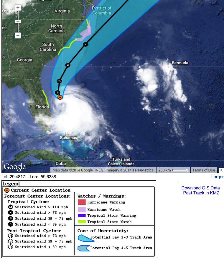
But models suggest that the depression will develop into a tropical storm and eventually a Category I hurricane and move north roughly parallel to the Atlantic coast. It will be called Tropical Storm Arthur, then Hurricane Arthur.
At present, there is a better than even chance that tropical storm force or stronger winds will be on shore in North Carolina, though there may be effects in South Carolina and Florida. Georgia too, but the Peach Tree state sits back west a bit so the chance of tropical storm level winds there is reduced. As the storm winds up and starts moving North, Florida will get a bit of a side long blow as well.
Here's the key timing, according to current forecasts which are subject to revision:
All indications are that the conditions for formation of this hurricane are favorable, and the National Hurricane Center is saying that the models are in close agreement. The main uncertainty seems to be how east-vs west the track will be, which will make all the difference in the world to the Outer Banks. A few miles here or there can make the difference between hurricane force vs tropical storm force winds striking the coast. There is the difference of a full-on landfall vs. grazing the coast at stake as well. The landfall probably won't happen, but it could. But do remember, a hurricane is not its own eye. Read this to find out what I mean by that.
UPDATE Tuesday 11:00 AM Central
The storm has been officially named and its name is Arthur.
Organization of the storm has improved and sustained winds are 33 knots at Grand Bahama Island, in a part of the storm that is not the strongest. Arthur is not drifting Northwest, as predicted by models. There is no significant change in the forecast but the official forecast:
Tropical Storm ARTHUR Forecast Discussion
Home Public Adv Fcst Adv Discussion Wind Probs Graphics Archive
US Watch/Warning
000
WTNT41 KNHC 011502
TCDAT1
TROPICAL STORM ARTHUR DISCUSSION NUMBER 3
NWS NATIONAL HURRICANE CENTER MIAMI FL AL012014
1100 AM EDT TUE JUL 01 2014
Radar and satellite imagery indicate that the convective
organization of the cyclone has improved since the previous
advisory, and the cyclone is being upgraded based on a sustained
wind report of 33 kt from Settlement Point (SPGF1) on Grand Bahama
Island earlier this morning that was outside of the deep convection.
After remaining nearly stationary earlier this morning, Arthur
appears to to be drifting northwestward now with an uncertain motion
of 315/02 kt. Otherwise, there is no significant change to the
previous forecast track. The latest model guidance has continued the
trend of a pronounced mid-tropospheric trough digging southeastward
from the upper-midwest into the northeastern and mid-Atlantic region
of the United States by 72 hours. The 500 mb flow pattern is almost
identical in the GFS and ECMWF models, which increases the
confidence in this evolving pattern. As a result, a steady increase
in southwesterly steering flow over the southeastern United States
is expected to gradually turn the tropical cyclone northward over
the next 24-36 hours, and then accelerate the system faster toward
the northeast on Thursday and Friday. By Days 4 and 5, Arthur is
forecast to move over the far north Atlantic as an extratropical
cyclone. The NHC track forecast is just an update of the previous
advisory track, and lies down the middle of the tightly packed
guidance envelope close to the consensus model TVCA.
Northwesterly vertical wind shear is forecast by the models to
gradually subside over the next 48 hours, which should allow the
cyclone to develop its own upper-level outflow pattern. In fact,
latest visible and water vapor imagery indicates that cirrus
outflow has been expanding on the north side of the system during
the past few hours, suggesting that the shear conditions could
already be subsiding. The low shear conditions and warm
sea-surface temperatures should allow for at least steady
strengthening, and the cyclone is expected to become a hurricane by
72 hours. The official intensity forecast is similar to the
latest intensity model consensus IVCN through 36 hours, and then
slightly higher after that.
FORECAST POSITIONS AND MAX WINDS
INIT 01/1500Z 27.6N 79.3W 35 KT 40 MPH
12H 02/0000Z 27.8N 79.4W 35 KT 40 MPH
24H 02/1200Z 28.7N 79.6W 40 KT 45 MPH
36H 03/0000Z 29.8N 79.5W 50 KT 60 MPH
48H 03/1200Z 31.2N 78.9W 60 KT 70 MPH
72H 04/1200Z 35.4N 75.2W 70 KT 80 MPH
96H 05/1200Z 40.8N 67.3W 65 KT 75 MPH
120H 06/1200Z 45.5N 59.5W 45 KT 50 MPH...POST-TROP/EXTRATROP
UPDATE 4 PM Central
Apparently the Hurricane Hunters went in to take a closer look at Arthur and enough unexpectedly strong turbulence that they had to change altitude to avoid getting jostled around too much. The Hurricane Hunters. Had to avoid turbulence. Must have been pretty bad. Anyway, they upgraded the wind speeds for the storm to 45 knots, and the forecast has been upgraded as well, but without much change.
FORECAST POSITIONS AND MAX WINDS
INIT 01/2100Z 27.8N 79.4W 45 KT 50 MPH
12H 02/0600Z 28.3N 79.4W 50 KT 60 MPH
24H 02/1800Z 29.2N 79.5W 55 KT 65 MPH
36H 03/0600Z 30.4N 79.2W 60 KT 70 MPH
48H 03/1800Z 32.1N 78.3W 70 KT 80 MPH
72H 04/1800Z 36.6N 73.6W 80 KT 90 MPH
96H 05/1800Z 42.2N 65.5W 60 KT 70 MPH...POST-TROP/EXTRATROP
120H 06/1800Z 46.8N 57.5W 45 KT 50 MPH...POST-TROP/EXTRATROP
UPDATE Wed 9: AM Central Time
Arthur has strengthened over night and has a large area of 45-50 kt winds in it's northeast and east quadrants. The central pressure is falling. So the intensity fo the storm is now set at 50kt. This is pretty much exactly on the button for yesterday's forecasts, so Arthur is behaving as expected with respect to strength.
There are competing strengthening and weakening factors and the storm is a bit lopsided, so future strengthening may be delayed. But, perhaps more important, the sea surface in the area is warm, as expected with global warming, and the vertical wind sheer is minimal, which is counter to expectations of global warming. THEREFORE THERE IS NO GLOBAL WARMING. Only kidding about that last part.
Anyway, at 6 AM central time the NWS predicted that Arthur will be a hurricane this time tomorrow morning or mid day. So look for that event on July 3rd.
The storm has started to move definitively north, and has sped up, but is only going 5 mph. Earlier forecasts had the track moved a bit east off shore, the latest forecast has moved the track back west again. Tropical storm watches have been issued for parts of North and South Carolina. Expect warnings by late PM today.
It is probably the case that the most important things that will happen with Arthur are severe winds general storminess in the vicinity, erosion along the outer banks, and storm surges along the coast west of the barrier beaches. The main concern for long term may be loss of some of the barrier beach real estate. But, if the main area of the hurricane stays off shore, there may be minimal major damage. Or, if the hurricane moves more to the west, this could be bad in spots. Note that it has been a long time since a hurricane has struck in this area. That makes for certain increased vulnerabilities, as well as some decreased ones (the latter with respect to erosion).
FORECAST POSITIONS AND MAX WINDS
INIT 02/0900Z 28.4N 79.1W 50 KT 60 MPH
12H 02/1800Z 29.3N 79.3W 55 KT 65 MPH
24H 03/0600Z 30.5N 79.1W 60 KT 70 MPH
36H 03/1800Z 32.1N 78.1W 70 KT 80 MPH
48H 04/0600Z 34.2N 76.0W 75 KT 85 MPH
72H 05/0600Z 40.0N 69.0W 75 KT 85 MPH
96H 06/0600Z 46.0N 62.0W 55 KT 65 MPH...POST-TROP/EXTRATROP
120H 07/0600Z 50.0N 55.0W 40 KT 45 MPH...POST-TROP/EXTRATROP
UPDATE: Wednesday 11AM NWS hurricane center discussion notes that the storm's intensity remains at 50 knots and the storm is moving northward at 6 knots. Arthur is expected to accelerate shortly. The storm looks like a real tropical storm in satellite views now:
UPDATE Wed 5:00PM
Arthur is strengthening as expected and with the latest information is being upgraded to 60 Kt strength. Here's the forecasted strength and position:
INIT 02/2100Z 29.7N 79.1W 60 KT 70 MPH
12H 03/0600Z 30.7N 79.0W 65 KT 75 MPH
24H 03/1800Z 32.4N 78.2W 70 KT 80 MPH
36H 04/0600Z 34.5N 76.0W 75 KT 85 MPH
48H 04/1800Z 37.2N 72.5W 75 KT 85 MPH
72H 05/1800Z 43.5N 64.5W 60 KT 70 MPH
96H 06/1800Z 49.0N 59.0W 50 KT 60 MPH...POST-TROP/EXTRATROP
120H 07/1800Z 53.0N 50.0W 35 KT 40 MPH...POST-TROP/EXTRATROP
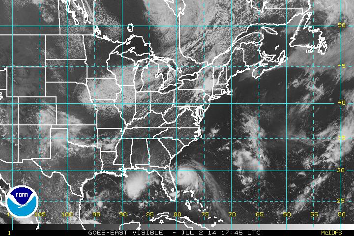
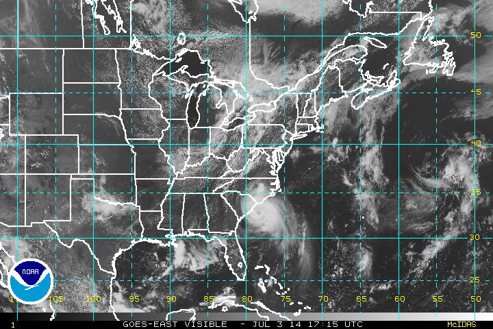
The graphic at the top of the post shows the estimated path. Here's what the Atlantic looks like right now:
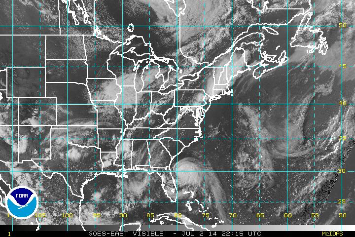
Arthur will probably be a hurricane by morning.
UPDATE 12:30 pm
Arthur will probably be an official hurricane over the next hour or two and it's predicted track, sublet to change, has shifted west to actually impact the Carolina coast.
UPDATE July 3rd, 8AM central
Arthur is now officially a hurricane.
Current intensity is set at 65 kt. As has been the case for the last few days, this is exactly as forecast. Remember some earlier recent hurricanes when the forecasts seemed to be very difficult? It is almost like Arthur is some sort of False Flag operation arranged by the NWS to make them look good. Thanks Obama!
Anyway, Arthur is expected to gradually intensify as it passes over warm water but then very quickly dissipate into extratropical vagueness perhaps by Saturday morning. The center of the storm should move very close to the Outer Banks in North Carolina during the night tonight. So tonight and early tomorrow, on the 4th, people in the Outer Banks area will be experiencing a hurricane, though the eye may or amy not make landfall. Soon thereafter Arthur will speed up and head out into the Atlantic.
80+ mph winds, heavy rains, and moderate storm surge will be the main threat.
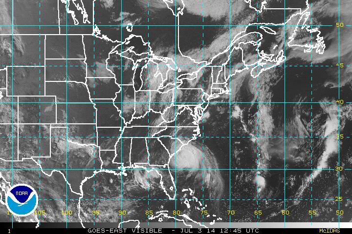
Arthur is already pretty much hugging the coast:
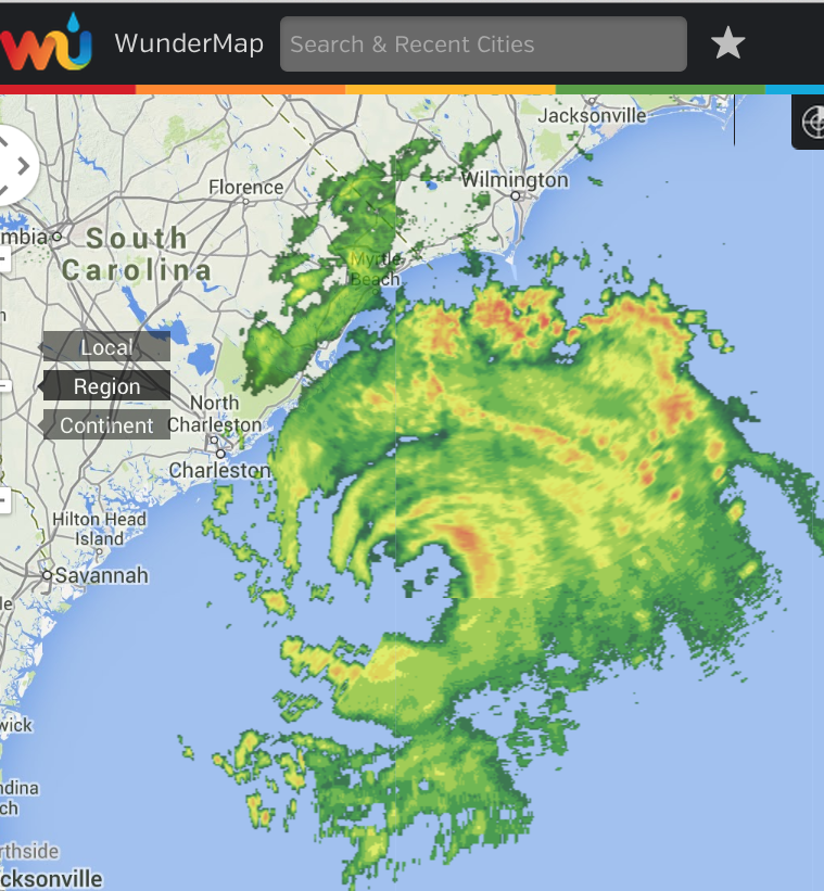
Here's a radar image from Wunderground.com:
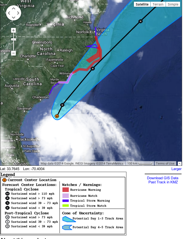
Here is the estimated track of the storm. It is quite possible that the eye will never make landfall, but the core of the hurricane, where winds may be sustained at 85 mph, will:
The National Weather service has a new highly experimental (as in you have to agree to not put too much faith into it before you look at it, so pretend you just did that) tool showing possible storm surge flooding in a warning area. This indicates widespread areas of potential flooding up tot 3 feet above ground at a conservative liklihood (about 10%). In other words, if you are in an are indicated for a 3 foot surge, there is a 1 in ten chance it will happen. That might seem like a very low probability. But, standing there in a storm surge is probably more likely to lead to death than having a person 100 feet away empty a revolver at you. (I have no idea if that is even close but I'm trying to make the point: You want to err on the side of caution when it comes to the actual Atlantic Ocean temporarily taking up residence where you actually are).
There are smaller areas of greater than 3 feet flooding. These are mostly within the outer banks (Thanks Outer Banks! Without you these numbers will be higher!) especially on the lee side of the banks (Today's quiz: Why would that be?) but also across large flat areas along the coast, mainly in wildlife refuges and such.
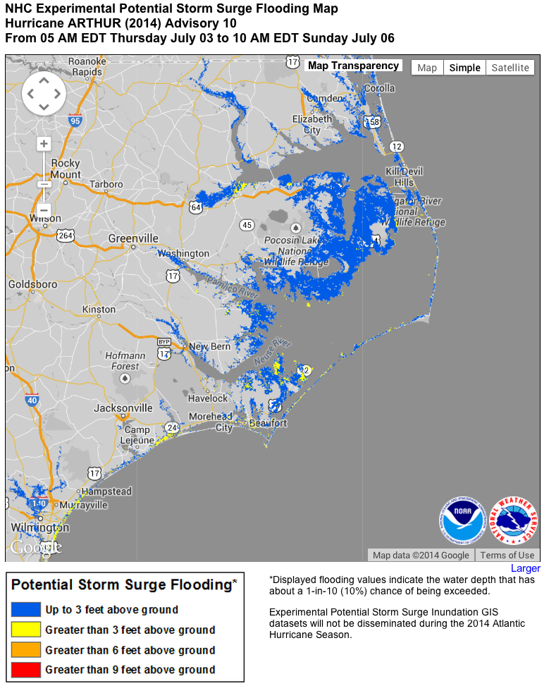
Most of the likely flooded areas are places where it is already low and wet. Comparing the NWS information to settlement maps I don't see a lot of risk to people's homes, etc. but if you live in the area you will want to be super aware.
The real big problem, as I see it, is the possibility of significant erosion to coastal wetlands which will have negative effects on regional wildlife for a few years, and also, will increase vulnerability to future erosion if another storm comes along before natural processes of restoration have developed.
FORECAST POSITIONS AND MAX WINDS
INIT 03/0900Z 31.3N 79.1W 65 KT 75 MPH
12H 03/1800Z 32.5N 78.3W 70 KT 80 MPH
24H 04/0600Z 34.7N 76.1W 75 KT 85 MPH
36H 04/1800Z 37.5N 72.6W 75 KT 85 MPH
48H 05/0600Z 40.9N 67.9W 70 KT 80 MPH
72H 06/0600Z 47.5N 60.0W 50 KT 60 MPH...POST-TROP/EXTRATROP
96H 07/0600Z 54.0N 52.0W 35 KT 40 MPH...POST-TROP/EXTRATROP
120H 08/0600Z 60.0N 50.0W 35 KT 40 MPH...POST-TROP/EXTRATROP
UPDATE 3 July 1PM Central
Hurricane Arthur continues to grow stronger with peak winds over 80 knots or higher. The official intensity is currently set at 80 knots (at 11 AM eastern) and rising. The storm will be a Category Two Hurricane prior to land fall or close grazing of the North Carolina coast. This is an increase in what was forecasted earlier.
FORECAST POSITIONS AND MAX WINDS
INIT 03/1500Z 32.4N 78.5W 80 KT 90 MPH
12H 04/0000Z 33.8N 77.3W 85 KT 100 MPH
24H 04/1200Z 36.3N 74.4W 90 KT 105 MPH
36H 05/0000Z 39.4N 70.2W 80 KT 90 MPH
48H 05/1200Z 42.7N 66.0W 70 KT 80 MPH...POST-TROP/EXTRATROP
72H 06/1200Z 48.5N 58.0W 50 KT 60 MPH...POST-TROP/EXTRATROP
96H 07/1200Z 55.0N 50.0W 35 KT 40 MPH...POST-TROP/EXTRATROP
120H 08/1200Z 60.0N 45.0W 35 KT 40 MPH...POST-TROP/EXTRATROP
Compared to the satellite image above, the storm is closer to the coast and farther north:
Here is the expected track:
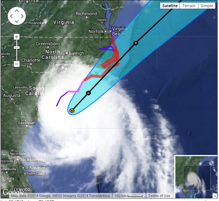
Notice that the eye of the storm is projected to pass right over the Outer Banks, but Arthur could easily pass farther to the West (less likely to the east).
How much warmer than usual? That question stems from your statement: "But, perhaps more important, the sea surface in the area is warm, as expected with global warming,..."
Michael, at the moment a couple/few degrees C above a climatology of 1985-1993. But I'm not sure of the exact configuration of SST and the storm's current or projected position. The North Atlantic in general is warmer.
What I don't know off hand and which may not matter with at category 1 hurricane is if we'll see medium depth effects like with Katrina and Yolanda, where the normally cooler (less than 80F) water meters below the surface is actually way warm, so as the storm churns up the normally cooling water it just churns up more hurricane-inducing warm water. I don't know if that is the case with the Atlantic now.
I have a question my man is working for the oil company so hes in middle of ocean in north Carolina is it affecting them to ?? Im like so worried .. ohh god plz keep them safe ..
Wendy they are probably either evacuating off shore rigs or battening down the hatches assuming they'll be safe. They have excellent information about he weather, very detailed, and a lot of time to make the right decisions. The scientists will provide good administration and the safety engineers will make a good decision to keep him and his colleagues safe.
SST values have not increased at all since the turn of the twentieth century. If people actually would look at the records this would be evident. The temperatures off the Atlantic seaboard are warm, but not unusually so at all. This is not unexpected, unusual, or in any way out of the ordinary. We need to stop irrationally blaming "climate change" for every storm that occurs and look at what neutral science actually reports.
No, you are wrong. You are so wrong I can only assume you are making this up. Run along now.
Greg, "neutral science" is most likely "science that tells Todd Pedlar what he likes to hear".
Even a few degrees warmer can cause some climate troubles. It will eventually melt the polar ice caps and we'll be stuck on water world. Make sure everybody gets a boat.
DO IT!!
According to every dataset I could get, SST in the NH has risen about 1.2 degrees C since 1850.