
Friday AM Update: Overall the storm has shifted north. Washington DC is still on track to have something close to two feet of snow in the city, more to the west. The predicted snowfall for New York City, the city that eats meteorologists, is increasing, and The City may see a foot or more, with closer to two feet to the northwest. DC will have its most intensive snowfall during the night on Friday, while New York City will have most of its snow falling during the day on Saturday.
With this northward shift, Boston is likely to get more snow too, possibly over a foot. Snow will start there during the afternoon on Saturday and continue through Sunday AM and early PM.
Wave and storm surge erosion with winds gusting to 50 MPH along the coast is still expected, especially along coastal New Jersey, Long Island, southern New England, Cape Cod, and down south across the Delmarva Peninsula. Normal tides are strong this time of month. Expect power outages here and there.
Regardless of the apparently senseless and, frankly, mean spirited comments we see from some of the climate science denialists (i.e., that blizzards have happened before therefore...) it is simply true that most of the big storms that have hit this area since good record have occurred in just the last few years. That's the observation. These storms are made worse by global warming enhanced sea surface temperatures. That's part of the mechanism. Changes in jet stream patterns have also probably played a role in both the concentration of moisture and the length of storms, and their tracks. So, yes, this is a global warming enhanced storm that earns an extra merit badge for having a bit of extra energy from El Nino.
See THIS for more about the science behind the predictions and the storm itself.
A quick update (Thursday 10:30PM Central). Not much change in the overall pattern, but the "most likely" amount of snow for DC and environs has increased. You'all are likely to get way over a foot, possibly 20 inches or so, maybe more. The minimum is 9 inches. That's not too likely. Overall, predicted snowfall amounts are increased. New York is expected to receive a half a foot or more, but as I note below this is hard to predict for that area. The estimate of snow for Boston has gone down, most likely an inch or so. But, that estimate has a fat tail, and it could be much more in the Boston area or East/Central Mass (up to 10 inches). Coastal flooding in New York, New Jersey, Delaware, Maryland and parts of Virginia are still expected.
I had previously mentioned Jonas, the storm about to bear down on the US East Coast. I cautioned that we should be open to a lot of possible outcomes, and to realize that prediction of exact snowfall amounts in a given area are very difficult with this sort of storm. Here, I'll repeat that warning. If you see a big blob of predicted snow on a weather map, you can be pretty sure that if you are within or near that blob, you'll get snow. But if you look at the exact locations of 12" snow here, or 6" snow there, and expect that to be accurate, than please contact me off line, I have nice bridge to sell you.
However, as the storm approaches the predictions get more reliable. In this case, multiple weather models have been in line with each other all along, and the convergence on a big storm with certain characteristics is emerging. The storm will affect land areas staring during the day Friday, and continue through the weekend, depending on your location.
What will happen in Washington DC?
One of the big questions is what will happen in DC. At the moment, some of the standard weather services are predicting five or six inches from between some time Friday and early Sunday in the DC metro. This is conservative, and if you are ramping up your expectations about this storm but are not going to be in the DC area, keep this in mind so later you can be all surprised at a larger amount. But if you are living or working in DC, you need to know that other highly reliable sources, such as the National Weather Service, are suggesting a larger amount.
Sticking with the idea that snowfall prediction is a game of probabilities, I offer this EXPERIMENTAL prediction method showing possible snowfall for a few spots in DC:
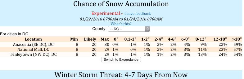
It is pretty obvious how to read this. This information shows that there could be as little as 8 inches across the DC area, but as much as 30 inches. The chance of the snow on the ground adding up to over 18 inches is better than 50-50, meaning that the chances of there being a mere half of this large amount (the 30 inch apocalyptic number) is also 50-50. There is about a 20% chance that the total snow will be less than a foot. This means, of course, that the good money is on a total accumulation of over a foot, possibly a lot over a foot.
In a place like DC, over a foot and over two feet are not that different. Both are city-shutting amounts.
By the way, I'm hearing rumors that in the greater DC area, out in Virginia and such, there was some icing and snow over the last 24 hours that the authorities in charge decided not to plow or treat, so driving conditions in the area are currently very bad. Just rumors, but from credible sources. Maybe the snow plow people are saving up their resources for the big one. (See this!)
Will New York City get much snow?
Yesterday it was looking like New York might get a few inches. However, overnight, various model projections have started to show a big lump of snow on or near New York, suggesting that the storm might have a bigger impact there. Right now, the National Weather Service is saying that there may be 8-12 inches of accumulation in New York.
New York is tricky because it has a strong urban heat island effect. Also, it is adjacent to not one, but two seas, and can be quite windy. Also, while New York has a lot of people in it, and the "Greater New York Area" is huge, overlapping large portions of three states and several counties (at least a dozen), when people go and look at the snowfall in New York City, they look at downtown Manhattan, and that is a tiny area (comparatively) that happens to be situated in a way that makes weather prediction extra hard. It is very common for a substantial snowfall predicted for New York to end up being nothing, or an inch or two. So, expect the unexpected. It is not unreasonable to assume a better outcome for The City than the forecasters suggest. But it may not be wise to rely on that assumption.
Will Boston get much snow?
In a way, Boston is even worse than New York. At the larger scale, Boston has a sort of barrier island, Cape Cod, which can influence some of the weather that comes its way, but Cape Cod is very far away covers only part of the sea in that area. Most storms sneak around it from the northeast. Nor'easters are not named as such for no reason.
Boston is a very small city surrounded by many, many other cities, that are together called "Boston" as in "I lived in Boston" but actually lived in Somerville or Medford or something. Also, Boston is in a basin (the "Boston Basin") snuggled up to the harbor and Mass Bay, and the highlands rise quickly (but not too much) around it, so it is not at all uncommon for Boston to get one inch of slush proceeded by some rain, while Lexington and Concord (commuting bedroom suburbs of Boston) get several times that.
And, in this case, the northern extent of More'Easter* Jonas is somewhere around Boston but nobody can say for sure yet.
The National Weather Service is suggesting that the worst case, but unlikely, scenario for the Greater Boston Area is 5-6 inches, the most likely 2-3 inches, but with a distinct possibility of zero. The Cape and Islands, and southern Rhode Island and SE Mass may get 6-8 inches. So, for that region, snowfall wise, just a typical winter snow but windy.
Where will the biggest accumulations be?
The biggest accumulations of snow are likely to be inland, at somewhat higher elevations, focusing around a couple of points. Here's a map I cribbed from Paul Douglas' blog:
No, wait, here is a more recent updated version, read the discussion below with that in mind:
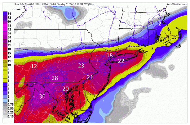
Technically, since over a foot of snow is a lot, the answer to this question is "everywhere form Long Island across most of New Jersey, half of Pennsylvania, Much of Virginia and West Virginia, and Maryland." But, there seems to be two major centroids of heaviest accumulation being predicted, one in New Jersey south of New York City, and the other wet of Washington across Maryland and the Virginia-West Virginia border. But, as I've now said a half dozen times or more, these sorts of snowfall projections are notoriously inaccurate at any level of detail. If you live anywhere in the area of this map bounded by the yellow stripe, expect snow. If you are in or near the red and purple zones, there is a chance you will be snowbound. So, run out to the store now with all the other people and get stuff.
The big problem with Jonas may be the wind
But when you do get to the store, if you want to be a True Survivalist, don't get frozen food or anything that requires electricity to prepare. And get extra batteries. And when you get home, do your laundry so you can get that done before your power goes out. The heavy snow amounts have the potential of knocking down power lines, of course, but there will also be windy conditions during this blizzard, and that will very likely knock a few wires off their poles. If this happens in many places over a large area, a simple outage that could be fixed in a few hours may take much longer. Between roads being closed because of snow and a high demand for repairs, some outages could last much longer than average, maybe even a day or a few days in the worst case. So be ready for that.
Coastal Erosion
My friend Paul Douglas referred to this storm as roughly like a "tropical storm with snow".* It isn't really a tropical storm, as he notes, but it is like one in the sense that there will be strong coastal winds and, owing to the winds and very low pressure, a storm surge in some areas.
The storm surge may be most severe between the central New Jersey coast and the Chesapeake. However, the effects of a storm surge are highly local. So, for instance, the Delaware coast, because of the shape of the coast line and its position in the maw of the fetch, may experience high water. Small embayments along the Jersey coast may see very high local surges. There will also be high water in the same areas where Superstorm Sandy rose up to flood New York City and nearby New Jersey, but the height of those waters will not be as bad as during that storm.
The other local phenomenon that determines the severity of a storm surge is, of course, local elevation. Areas with low relief behind the strandline facing the ocean may see several feet of water washing inland, and serious damage to property and natural areas. Places where the land rises quickly behind the beaches will still be affected by wind and spray (expect to see a lot of damaged or dead trees in some areas next spring form the salt) but structures and roads would be less affected. Pay close attention to what your local authorities are saying. At this point, though, the storm surges are expected to cause possibly record-book altering floods. From Paul:
Unseasonably warm water in the Gulf Stream will fuel rapid intensification and pressure falls, a partial vaccuum that will pull air into the core of this developing Nor'Easter, whipping up high winds and pounding surf; the rough equivalent of a wintertime tropical storm (without the warm core). Here's an excerpt from WXshift: "...On Saturday, powerful winds in excess of 60 mph could whip up waves that could reach 30 feet. As they come ashore, beaches will take a pounding and face widespread erosion. Models also show a current storm surge of around 5 feet coming ashore with Saturday’s high tide. In Cape May, N.J., the current forecast high tide mark on Saturday evening would be the third-highest on record while Atlantic City would come in at 10th in the record books, according to Stephen Stirling at NJ.com. That could push water inland and cause widespread property damage..."
Bottom line: If you live or work in a place within the range of this storm that has been storm-flooded in the past, assume this is a possibility this time.
UPDATE: The storm surge and coastal flooding is starting to ramp up as one of the more likely negative outcomes here. Paul Douglas just sent me these words of warning: "I'm increasingly concerned about the threat of widespread coastal flooding from this super-sized Nor'easter. Blizzard and 50+ mph winds arriving during full moon with sustained onshore winds creating a 4-7 foot storm surge capable of lowland flooding and beach erosion. Facilities that were impacted by Sandy in 2012 may experience problems with this storm."
The National Weather Service in New York is warning that this may be one of the top five flooding events on record in the area.
THE MOST SIGNIFICANT COASTAL FLOODING MAY COCUR AT HIGH TIDE SATURDAY EVENING. So check your tide chart.
More'Easter*
So, when Paul made mention of the "Tropical Storm with Snow" to some mutual colleagues, the idea came up that this sort of storm needed a new name (Snowicane, or something like this). I suggested that during the last two decades, there have been more Nor'easters, with more moisture and precipitation, covering more geographical areas (mainly to the south) than in the past. So, maybe the term "More'easter" would be appropriate. Paul anointed the idea, and now you can use the term as well, if you like. I don't expect the meteorology textbooks to be updated any time soon, but who knows?
A quick word about climate change and El Niño
Yes, this storm is getting its extra moisture and power from climate change with a does of El Niño added in. The driver of this wetness (which will be snowness) is very high sea surface temperatures in the Atlantic. El Niño influences this, but frankly, the sea surface temperatures off shore right now are not a lot different than they were last January, when a huge More'easter blanketed New England in a big pile of snow. This is a global warming enhanced storm.
“Yes, this storm is getting its extra moisture and power from climate change with a does of El Niño added in. The driver of this wetness (which will be snowness) is very high sea surface temperatures in the Atlantic…This is a global warming enhanced storm.”
The Atlantic’s GW enhancement may have been in greater 94 years ago, at least for Washington, D.C.
That's when they got their all-time record – 28 inches!
http://www.nbcwashington.com/news/local/Ten-Worst-Storms-in-DC-History-…
Hey, See Noevo found an anomalous event at one particular time in one particular place! Good job!
Truly, you have a dizzying intellect.
sn: it's been pointed out to you numerous times that the fact there were large storms years ago does not mean discussions of and about storms currently active are incorrect, no matter how strongly your feeble little dishonest intellect wants them to be.
See-No-Context can always be relied upon for cherries.
An interesting thing about ice ages is that, initially, the winters may be warmer and the summers cooler which means more snow accumulation in winter and less melting in summer. So a decrease in the temperature differential between summer and winter such as is caused by orbital variations (with no change in the average) can lead to an ice age.
However, unlike the conditions leading to an ice age, our (we caused it) global warming is increasing the temperature in every season. We might be lucky to get a positive ice balance change in some seasons and in some places but usually it's negative.
Plenty of flooding on the New Jersey coast. Governor Christie did not consider global warming a "crisis" in December of 2015. I wonder how many extreme events it will take to raise his level of concern to that of "problem" or "worthy of consideration"? Or are his opinions about climate change strictly molded by the amount of petro-dollars in his campaign war chest?
Coastal New Jersey communities are now suffering their second major flooding event in less than four years. This must be disheartening .
As to attribution... we know that global warming is raising sea level through ice melt water and through local changes like slowing of the Gulf Stream. Sandy was a record sized storm. Jonas has broken a number of records. Is this all just bad luck for New Jersey? Is this all just a bad combination of natural effects like high tides, el Nino, and random weather? Or are these harbingers of more infrastructure wrecking climate change to come during Christy's term? How much of a putz is governor CC going to prove himself to be?
Stay tuned.