
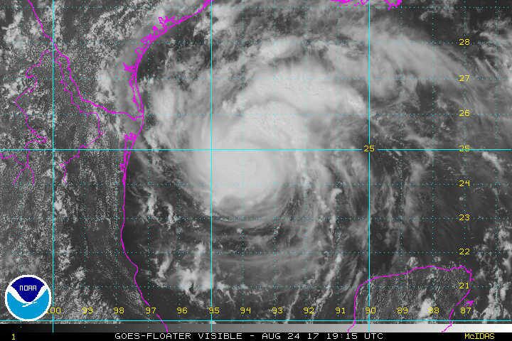
Harvey the Hurricane will hit Texas roughly between Corpus Christi and Victoria (but stay tuned for exact details).
Harvey is passing over water that is significantly warmer than usual, owing to global warming. This storm was too disorganized to even, under normal conditions, to have a name, just a day or so. But, when this storm hits Texas late this week (maybe by the time you are reading this) it is likely to be a Category III storm.
Then, after landfall, the storm will hang around that area for a while dumping huge amounts of rain on the Texas flatness.
The target area may have 15 inches of rain or more over fairly large areas. There may be spots with more than 25 inches. This is one of those storms that requires the weather forecasters to add new colors to their usual maps.
The last "major hurricane" (Category 3 or larger) to hit the US was Wilma in 2005.
This is an area with abundant oil extraction and processing facilities which are subject to damage from large storms.
Since the ocean has risen since the last major storm surge in this area, local residents and businesses need to make an adjustment in their expectations. If you are in the area look at the National Weather Service's science based information on storm surges. They have some new tools available. Good thing they have not been removed yet!
For more on the link between this storm and climate change, see THIS.
Added Aug 24 9:30PM
This is probably not going to happen, but ...
https://twitter.com/GCarbin/status/900887170440941568
We don't know how strong this storm is going to be, but a lot of experts are saying they are above average worried.
UPDATE: Friday AM
Despite rumors of weakening, the storm continues to strengthen. The main change in forecast is that the center of the storm's expected landfall is father south than expected, away from Houston, but Houston will still receive a great deal of rain, maybe most of the high rainfall amounts.
Storm surges of up to 9 feet or more are possible around Victoria and Corpus Christi.
How much difference does 1.4 inches make in storm surge?
I am assuming 3 mm per year, times 12 years.
Thinking about this a bit more - I would think the timing of the storm surge would be a much more important effect. The difference between hitting at high tide versus low tide would be much more than 1.4 inches (I would assume).
So I am guessing the higher sea level is a very minor effect, and could be completely swamped by tidal effects, unless the storm surge just happens to hit at peak high tide, which would add 1.4 inches to the storm surge.
RickA@1: If your storm surge defenses can handle a storm surge of X but be overtopped by a storm surge of X + ε, then you do need to worry about it.
Now consider that a large fraction (if not a majority) of the US's gasoline refining capacity is on the east side of Houston, which is potentially in the path of the storm, especially if the track shifts eastward. And that despite the requests of the City of Houston for state funding to help harden these facilities against weather disasters, the state of Texas has done nothing.
One more thing: Harvey is predicted to stall just after landfall. Which means lots of rain throughout southeast Texas, and the potential for catastrophic flooding. Some reports are suggesting that localized amounts of as much as 30 inches (that's about 750 mm, in case any non-US people are reading this). There is very little topographic relief in that part of Texas, so all that water is going to drain rather slowly. Elevated sea levels will make that problem worse as well.
Bottom line: This has the potential to be really bad, not just in southeast Texas but all over the US, if large amounts of that gasoline refining capacity were to go offline.
>The last “major hurricane” (Category 3 or larger) to hit the US was Wilma in 2005.
At the time, between that and Katrina, people were saying it is because of global warming and to expect it to happen more often.
Kudos to Greg for not repeating it here.
"So I am guessing the higher sea level is a very minor effect,"
You would be wrong. What are you using to guess with? There's an entire internet to learn from you there. Stop pulling from your ass and start thinking.
The extra sea level s ocean wide. The ties do not rise more than several inches, the sea across the ocean is gathered and sets itself higher because of that gather to be several feet in difference. Rising sea levels will do that an more, since the tides is part rise and part fall, not all rise.
Surges too will be higher because the water can fetch all the extra ocean along the entire reach of the surge. A couple of inches will easily pass a few feet in peak.
It all depends. A storm surge in a flat wide ocean against a flat wide strandline has close to a 1:1 ratio, so a one inch rise in sea level causes nothing interesting. However, the storm surge is normally channeled into areas of decreasing width. If the surge is concentrated into a tenth of the space, which is typical, then multiply by ten. So a 1.4 inch storm surge is over a foot of extra.
The strorm surge may not be the problem as Eric point out, in the refinery and port area, as much as the flooding. See the other post I just put up for info on that.
If the rain really is upwards of 30 inches around Houston there may be pretty heavy flooding there!
There's not much of an issue with flooding in the middle of the ocean, though, is there! If it WEREN'T flooded in the middle of the ocean, *then* maybe you got a problem.
But increased volume has a bigger multiplier than tidal forces because tidal changes are a net zero. And if the sea floor is slightly further away the waves can travel longer and faster (the reason for the breakers being the shear flow between the top and the bottom of the water vortex that is caused by the winds on the surface of the ocean, and the nearby floor slows down the bottom of the water).
So storm surges will be bigger and the waves reach land at higher speeds.
Wow #5 and #7.
Tidal changes are a net zero.
So it makes no difference if the storm surge from a Hurricane happens to hit at high tide!
Good to know.
Yes. Because where the tidal forces can't make there be more water in the ocean.
But melting ice can.
Oh, and where did you hear that it didn't matter if there was a surge at high tide, moron? You fuckwitting again?
Re: #1 & 2
Flooding and not flooding can be a matter of inches. My house had a high water mark on my front lawn near the porch. my across-the-street neighbor had water in his house.
Tides in the Gulf of Mexico (my local ocean), as in the Mediterranean, another landlocked sea, are not very large, a foot or so if that. Still, if you're at the edge of a storm surge a foot can make all the difference.
Re: #6
Flooding during hurricanes Rita and Ike in SW LA & SE TX resulted from huge storm surges (20 ft or so) that pushed water up the rivers and bayous (and piled up the formerly downflowing water) creating widespread flooding in areas even 8 feet and more above mean sea level 30+ miles from the normal shoreline. Throw in wind damage (roof damage. falling trees & utility poles and you've got a grade A mess.
Tides are definitely an important factor. Cyclone ITA was a category 4 Cyclone when it hit the coast just North of Cairns in 2014, but it had luckily slowed (and weakened) so its arrival coincided with low tide. The storm surge didn't overtop the walls around the esplanade and only caused a minor amount of flooding up the storm water system into the streets.
With a local tidal range of about 3 metres, the 5 metre surge hitting at low tide made all the difference.