
UPDATE Sept 9, AM
Note that tropical storm force winds may start hitting southern Florida around 1 or 2 PM today, Saturday, and will reach central Florida by about 8AM Sunday.
The eye of the storm should be abreast southern Florida at around sunup on Sunday. The storm may remain a major hurricane as it moves all along the west coast, reaching south of Tallahasse, still as a major hurricane, Monday morning.
Irma has interacted with Cuba more than previously expected. The storm also seems likely to move farther west than previously expected.
Moving over very warm waters over the next several hours will strengthen the storm. If it does move along the west coast of Florida the focus now shifts to different communities, such as the Cape Coral / Fort Myers area.
As a rule, storm surge risks on the west coast are greater than the east coast. The west coast has a broader shallow shelf, and since the hurricanes rotate counter clockwise, there is a greater chance of a direct hit. Correspondingly, the following storm surge map (most current version HERE), which has inundation of over 9 feet if conditions pertain in a given spot, is what we should be paying attention to:

It also seems to me that the keys are in more danger with this track than with the central track.
Here is a reasonable likely scenario, WHICH IS SUBJECT TO CHANGE based on current consensus.

Over-simply put, there are two things that determine the future location of a hurricane. One is the simple long distance movement of the major air mass that is our lower atmosphere. The hurricane is like a cork floating along in a stream. If the stream flow is steady and straight, the cork will be just down stream from where it is now, moving alongat an easily discernible rate, so the distance over a fixed time interval is easy to calculate.
The other factor is all the other stuff. The complex movement of other low pressure systems and ridges of high pressure, all that. The land and the ocean have their own things going with respect mainly to high and low pressure, so as a hurricane moves from being out at sea to being on or near land, these interactions grow increasingly complex. Over the next several hours, this second factor (everything else) takes over and this is where the prediction gets complicated. How much exactly will the storm change its angle of movement, and exactly at what hour will that occur and how long will it take?
So, the tack above looks pretty solid but it may in face be off by a hundred miles or even more before the storm is abreast of southern Florida. That difference will make all the difference in the world.
Update based on NWS advisory Sept 7, late PM
A Hurricane Warning is in effect for...
* Dominican Republic from Cabo Frances Viejo to the northern border
with Haiti
* Haiti from the northern border with the Dominican Republic to Le
Mole St. Nicholas
* Southeastern Bahamas and the Turks and Caicos Islands
* Cuban provinces of Camaguey, Ciego de Avila, Sancti Spiritus, and
Villa Clara
* Central Bahamas
* Northwestern Bahamas...
Maximum sustained winds remain near 175 mph (280 km/h) with higher
gusts. Irma is a category 5 hurricane on the Saffir-Simpson
Hurricane Wind Scale. Some fluctuations in intensity are likely
during the next day or two, but Irma is forecast to remain a
powerful category 4 or 5 hurricane during the next couple of days.Hurricane-force winds extend outward up to 70 miles (110 km) from
the center, and tropical-storm-force winds extend outward up to 185
miles (295 km)....
The combination of a life-threatening storm surge and large breaking
waves will raise water levels ABOVE NORMAL TIDE LEVELS by the
following amounts within the hurricane warning area near and to the
north of the center of Irma. Near the coast, the surge will be
accompanied by large and destructive waves.Turks and Caicos Islands...15 to 20 ft
Southeastern and central Bahamas...15 to 20 ft
Northwestern Bahamas...5 to 10 ft
Northern coast of the Dominican Republic...3 to 5 ft
Northern coast of Haiti and the Gulf of Gonave...1 to 3 ft
Northern coast of Cuba in the warning area...5 to 10 ft...
RAINFALL: Irma is expected to produce the following rain
accumulations through Saturday evening:Northeast Puerto Rico and the British and U.S. Virgin Islands...
additional 1 to 2 inches
Much of the Bahamas and Turks and Caicos...8 to 12 inches, isolated
20 inches
Andros Island and Bimini, Bahamas...12 to 16 inches, isolated 25
inches
Northern Dominican Republic and northern Haiti...4 to 10 inches,
isolated 15 inches
Southern Dominican Republic and southern Haiti...2 to 5 inches
Eastern and central Cuba...4 to 10 inches, isolated 15 inches
Southeast Florida and the upper Florida Keys...8 to 12 inches,
isolated 20 inches
Lower Florida Keys...2 to 5 inches

Update Sept 7, PM
Everything I said in the last post applies now except the chances of the storm making landfall on the Florida Peninsula, and even the chances of a fairly direct hit on Miami and surrounding areas, is much higher than it was this morning. But we are still talking about something that will happen in the middle of the weekend, and this is still Thursday.
Also, repeating, note that if this storm makes landfall at the southern tip of the Florida peninsula, it is expected to move north very quickly (about twidce as fast as it is moving now) and reach southern Georgia WHILE STILL BEING A HURRICANE. A land hurricane, if you will. Except of course huge parts of it will be handing out over the very warm Atlantic.
I heard a guy on the news today saying the only ticket he could get out of Florida was a one way flight to Memphis. The hurricane will be in the vicinity of Memphis, or at least central Tennessee/Kentucky, Tuesday. It will be a big wet storm at that time, but that is an area that floods so take it seriously.
This might be a good time to read this post if you haven't already: Hurricane Landfall: What is it and don’t be stupid about it.
Update Sept 7, Mid Day
Storm surge watches have now been issued for South Florida. The experimental storm surge system of NWS suggests storm surges of up to 6 feet or so in a few places. But, the details of where storm surges may happen and how high they might be will probably sharpen a great day between now and Friday late PM.
Mean while, do the same with storm surge information as I asked you to do with the overall Hurricane information below. Recognize how this information is produced and what it means. There will NOT be a storm surge of the maximum amount indicate on the maps in all the areas covered by the map. The way to use the map is this: If you are in a particular spot with a possible storms surge, the map tells you your local worst case scenario, the scenario you should be prepared for even though something less is probably what is going to happen. If you assume less will happen and are washed out to sea and never seen again, don't come complaining to me, because that is NOT what I said. If you are in a place where it says 6 foot surge, and you get a 3 foot surge, that is normal. Hopefully, though, you are no where hear the south Florida coast, right?
You can see the storm surge maps here.
Update Sept 7 AM
I want you to look at this graphic and understand its meaning:
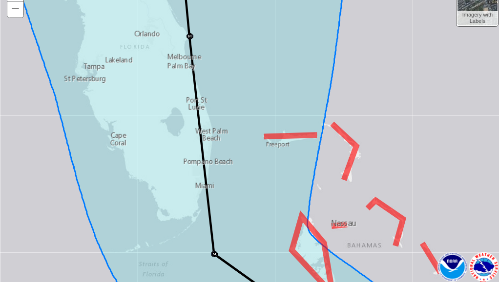
There is about a 70% chance that the CENTER of Irma (the eye, approximately but not exactly) will remain between the two blue lines between midnight Saturday and midnight Sunday as it first interacts with Florida. In other words, between those two "m" markers. So, you have to start out by imagining the hurricane's eye in the Gulf over by Cape Coral, and think about that for a moment. Then, you have to imagine the eye out near Freeport and think about that for a moment. With each of these scenarios, understand that the Miami and Miami Beech area is in a bad storm, windy, lots of rain, probably flooding, etc. but not Houston and not Andrew.
Now, look at the black line with the "M" markers on it. As you move from either blue line towards the black line, there is an increasing chance of the center of the storm being there. It is a bell curve, where the high point of the curve holds that black line. So there is a better chance that the center of the storm will be near Miami than Tampa or Freeport.
Now let' consider the structure of the storm itself. Catastrophic sustained winds and gusts extend out from the center of the storm about the same width ad Florida itself, but as the storm approaches Florida it will weaken. The strongest wind and most severe storm tides are in the front right quadrant. So, if the storm comes on land in Florida along the southwest tip of the peninsula, that front right punch is going to only graze Miami but will obviously be very meaningful in the keys and everglades. If the center of the storm passes to the right of Miami about the same distance, perhaps Grand Bahama is toast, but Miami and Miami Beech is hit hard but it is a mere bad disaster.
What are the chances that the storm will essentially ride this black line all the way? Low. Maybe 10% chance. But if it does, or does something close to that, what happens?
There are three things to know, one of which I've already mentioned. That is that the front right is the most important part of the storm. So, if the storm is close to riding the line, but off to the right 10 miles, that is hugely different from if the storm is close to riding the line but off to the left 10 miles. The difference is in the survival of this urban area, potentially.
Second: Note that there is an M on the track south of Miami, and another one north quite a distance. The lower M corresponds to sustained winds of about 150mph, the upper M to sustained winds of 120 mph. So, as the storm moves over the area, it will weaken but it will be very strong anyway.
Third: The shape of the coastline, as discussed and depicted below, in an earlier update, means that the storm surge coming up into the Miami Beach area could be very high. The Hurricane Prediction Center has not posted storm surge estimates at this time, but depending on the exact path of the storm there could be many many feet of flooding over a very large area in and around Miami.
Or, again, the storm may be nothing more than a bad day for the Magic City. Remember that. We still do not know.
Beyond this, there is other complex bad news. Even if Irma scrapes the Atlantic coast of Florida, it may remain a hurricane all the way up to the Carolinas. If it misses Florida, it may go north and then hit the Carolinas with more force. Or it could go into the gulf, or miss everything. Still too early to tell, but Florida looks to be in some sort of trouble.
Remember, mainly, that despite what the news agencies are saying, there is currently no valid prediction of what Irma will do over the weekend. So, if it does something that you were not expecting, that's you. You don't get to say "but they said yada yada" because they are saying nothing more specific than the vague and rambling things I said above.
Update Sept 6, late AM
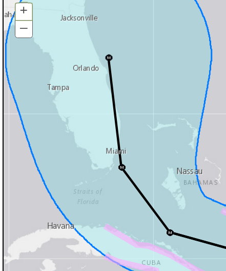
Just hours after the NWS five day put Irma dead in the middle of Florida's south coast, the newest estimate is quite different. I point this out to underscore what I've been saying all along (and I hope you have not been ignoring): Five days out is too far to be accurate. Look:
Update Sept 6, AM
I keep seeing news phrases like "Irma has Puerto Rico in her sights." Puerto Rico will have some very bad weather, but the main path of the storm has never crossed the island, and there is probably a less than 10% chance of a direct hit there, or less. The small islands of the northern Leewards have been hit directly or close to it, and more are in trouble. It seems most likely that the first larger body of land Irma might strike is Cuba, which has is almost entirely within the cone of probability, but south of the central line of expected movement. If the storm interacts a lot with Cuba, or turns into the island nation, that will be bad for Cuba, and Irma will weaken considerably. Meanwhile, the Bahamas and islands between Irma and the Bahamas are likely to get hit hard.
The more accurate three day forecast puts Irma as a Major Hurricane between Cuba and the Bahamas, or hitting Cuba or the Bahamas. The much less reliable five day forecast has Irma then curving north and striking the very tip of Florida and moving, as a major hurricane, onto the peninsula.
However, as a target, Florida is small compared to the cone of uncertainty Look:
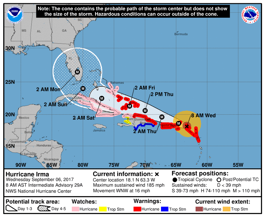
Given this, it is distinctly possible that Irma will pass to the right (east) of Florida and head up the Atlantic. If that happens, it may then strike the mainland somewhere else, or not. Or, given this probability map, it is possible that Irma will pass to the left (west, gulf-side) of Florida, and go into the Gulf, then it will be pretty much impossible for the hurricane to not hit something.
The fact that the middle of this forecast graph is centered on Florida does not mean that it is more likely that the storm will hit Florida head on than not, given the wide margin of error and the relative narrowness of the state from this angle. I am emphasizing this because I don't want to hear any bellyaching later if Irma skips Florida and hits Louisiana or South Carolina or something.
Either way, Irma is expected to be making whatever northerly turn it is going to make during the night time hours between Saturday and Sunday, and the current (but too far out to be certain of) projection is that Irma will be a Category 4 hurricane at that time. By Sunday night, Irma will have hit Florida, dead on, or not, and is expected to be a Category 3 hurricane on land and inland a ways, if that happens. In other words, worst case scenario includes southern Florida suffering a major hurricane for over 24 hours straight.
It has been said over and over again that the real risk of death in a hurricane is inland flooding that often happens after the hurricane has come ashore, and not so much from the coastal flooding and the winds. I'm not going to exactly dispute that but I want to complexify it a bit. If we count all the hurricane dead in the US, the most people who have died of hurricane effects were killed in the coastal storm surge of one single storm. That is not an outlier in the classic sense (i.e., a number that is so out of whack that something must be wrong with the number). It is a real number but an extreme one, however, and meaningful averages should probably ignore it.
But I bring this up now because it might be that a catastrophic hurricane will come ashore in an area where a lot of people live on low ground. There could be a storms surge that is substantial relative to the topography, and there could be winds strong enough to flatten homes and buildings and, generally, structures previously thought to be storm shelters. In other words, a worst case version of Irma would have a deadly storm surge and a deadly wind, more so than Atlantic hurricanes tend to have. Then, of course, the inland flooding as well, maybe quite substantial.
Storm surges are more extreme when there is focusing terrain, like a bay flanked by high hills leading to a town or city. In such environments, however, the storm itself is likely to suffer attrition from the nearby mountainous topography. In the case of Florida, the good news is that there are not hill flanked embayments, and the bad news is that florida is as flat as a pancake, so the storm will not be reduced from that sort of friction.
There are some potentially very uncomfortable scenarios. Look at a map of the Miami and Everglades area.
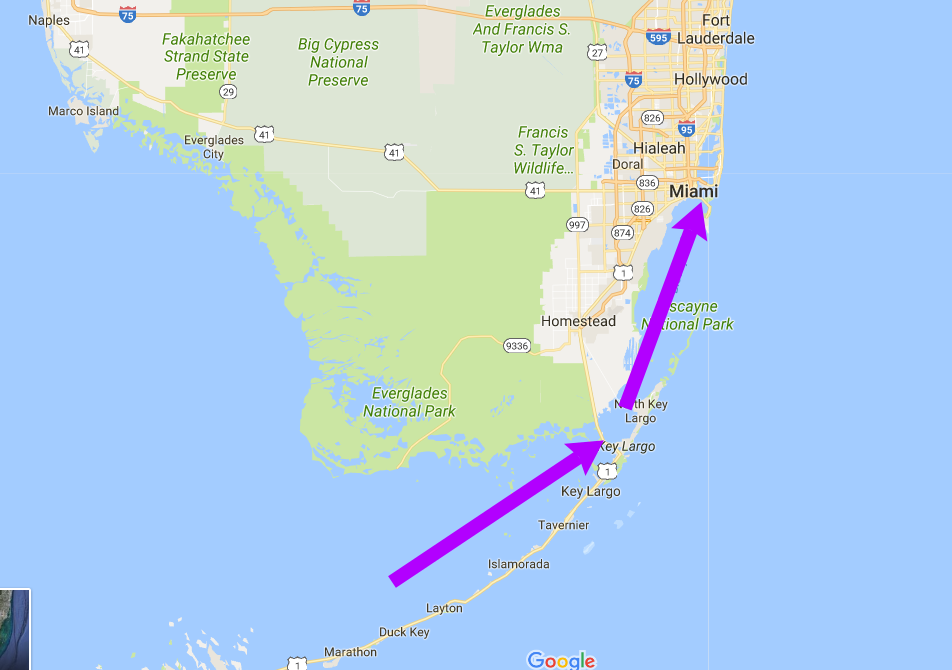
Now imagine a counter-clockwise spinning storm, centered close to the very southern tip of the state. Besides sweeping high winds along teh keys, it may also force a storm surge up the lagoonish area west of Key Largo, up into the northern part of Biscayne Bay, and right up into the waterways of Miami. I would not want to be on Dodge Island if that comes through. Also, northern Biscayne Bay could be flooded and the outlets to the south blocked, so any of several smaller low spots or outlets in Miami Beach may volunteer to be the new channel connecting the bay to the sea. That would be locally very very bad.
Miami is thought to be less vulnerable to storm surge than other cities, because the sea deepens fairly quickly off shore, which decreased the amount of surge that is possible. But, this particular hurricane, coming from the south and being large, obviates that benefit because the storm surge could be coming through the zone behind the Keys, which is very very shallow. Even if Miami itself is spared, the areas around the keys themselves, and the everglades, are pretty vulnerable.
Or, Irma may do nothing like this, and go somewhere else. We'll soon find out.
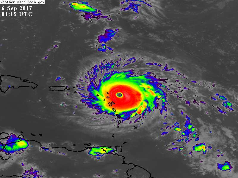
Update Sept 5, evening
In the fairly current infrared image below, Irma is clearly bearing down on some land masses. The twin (double) blobs south of the eye just being engulfed by read is Guadeloupe, and the largish two islands south of that are Dominca and Martinique. The several tiny dots right in the path of the eye or near it are Antiqua and Barbuda, Monserrat, St Kits & Nevis, and Anguilla. You probably recognize Puerto Rico; the tiny dots in the blue specked area between Puerto Rico and Irma are the British and US Virgin Islands.
These island are on the elbow of an ark that runs from Grenada to the Greater Antilles. This mostly volcanic island arc, rimming a small continental plate, would be a large arm of much more land and much less sea during low sea level stands of the Pleistocene.
(I just thought I'd mention that because you probably want to know some things about these islands that are about to get blottoed.)
It is still too early to predict what Irma will do when it is nearing the end of its path along the Greater Antilles and Leeward Islands, i.e., when it is nearer the US mainland. To give you an idea of how uncertain all this is, the average of all the models had Irma striking Florida at the end of the peninsula, but now, hours later, there are other models that tend to be pretty reliable showing Irma not hitting Florida at all, and rather, striking land in the Carolina region.
What this means is this: If you are in Florida and preparing for a hurricane, continue to prepare. If you are in South Carolina and thought you dodged a bullet on this one, don't assume that.
The one thing we are 70% sure of: Late PM on Friday, Irma will be somewhere between eastern Cuba and the Bahamas. Probably. But possibly not.
Update Sept 5, mid day
We have been back and forth on Irma all along, with the possibility of a landfall in the US being very uncertain.
I'm here to tell you that it is still uncertain. There are still some models that show the storm curving north and becoming one with the Atlantic.
However, most models are showing Irma hitting the continental US, and of those, Florida seems to be a favorite spot.
Several models indicate that Irma will interact with Cuba before heading north and running into Florida. It will not cross Cuba on the way north, but rather, veer into Cuba from the North and maybe not even make eyewall landfall there. It is hard to say what this will do but likely the storm will weaken before hitting Florida.
Also, generally, reports of the storm's strength are exaggerated. It is now a very powerful storm and it could become more powerful but there is almost no way Irma will not decrease in strength, down to a Category 3 or even Category 2 before hitting the US, if it hits the US. There are reasons that Atlantic hurricanes are not as big, not as powerful, and not as persistent as many Pacific storm, and those reasons have not applied to the storm in recent days, but will start applying to the storm now and onward.
Nonetheless, it is very likely true that somewhere in the US there will be a serious hurricane, possibly a major hurricane, hitting something.
Meanwhile Irma is starting to impact land and will continue to do so for several days, mainly on islands.
So, here is a reasonably likely scenario for the next several days, in DECREASING order of certainty as you go down the list.
1) Certainly: Irma is at the moment impressing the heck out of weather watchers. It has a very clear and distinct eye with interesting features. The winds are very very high, and it is classed as a Category five hurricane. At this point, Irma is not merely a major hurricane, but rather, a catastrophic hurricane (that's not an official word, but it is a word that will be used on the Leeward Islands ... there is a good chance the name Irma will be retired).
There are hurricane warnings in effect for Antiqua, Barbuda, Anguilla, Monserrat, St. Kitts, the Virgin Islands, Puerto Rico, and other locations. Between Wednesay AM and early morning Thursday, approximately, Irma will bear down on locations between St. Johns and Puerto Rico. It will likely hit the first islands more directly with the center passing north of Puerto Rico, but it will affect everything in that area and this is going to be a disaster. A direct hit on Puerto Rico is in the range of possibilities.
2) Probably: Between perhaps Thursday AM and Friday mid day the storm will weaken slightly. It may pass north of Hispaniola and eastern Cuba, but a direct hit on DR and Cuba is well within the range of possibilities. If so, it will weaken more, if not, it will weaken less.
3) Maybe, maybe not: Between 4 and five days out, so starting in the middle of the weekend, the storm, still weaker but still possibly a major hurricane, will either be interacting with Cuba or staying north of Cuba, and poised to hit, possibly, Florida. Or not.
If you live in Florida, it would be good to assume you need to react to a major hurricane. If you live in the keys, south of Miami, or the Miami area or the southern Gulf area, and this storm hits Florida, you will need to be paying close attention.
By Thursday it should be a lot easier to say if Floridians, or some other group of people on the US Mainland are in trouble. Whatever you can do to be ready for a Hurricane that is non-committal and reasonable, do now, and you should probably have done that at the beginning of the season.
Update Sept 2, PM
Underscoring the futility of making projections of a hurricane's path beyond five days out, the bulk of the models now show Irma hitting the East Coast or sliding around Florida and hitting the gulf. One puts it through the Louisiana-Mississippi border, one has it heading for Halifax, and then all the others are in between.
What does this mean? In terms of projecting the hurricanes ultimate path or chance of landfall, and location of any landfall, it means nothing yet. However the fact that this category 2 storm is likely to become category 3 storm over the next few days, and then will head in the general direction of land, means, well, that it gets its own blog post (this one) for now, if nothing else.
Update Sept 2 AM
The latest models, still too early to tell but there they are, mostly have Irna going off to sea. A couple have the storm hitting the east coast. None have the storm in the gulf.
Updated Aug 31 Mid Day
Two new developments in expectations about this storm, but all very provisional.
First, the storm is intensifying more quickly than expected, and it is expected to become a very powerful storm, ultimately.
Second, while earlier projections from many models allowed for a very wide range of possible paths, the models, still being worked far too out in time but also converging significantly, are starting to suggest that Irma's most likely course will be to curve up the Atlantic. This involves the possibility of landfall anywhere from the middle sates north to Canada, or no landfall at all. It is still too early to say, but it is looking unlikely for this storm to go into the gulf, but at least one or two models do allow for that.
Updated Aug 31 AM:
Here's a tweet that shows the current range of model projections for this storm (Note it is way to early to actually predict this far out, but this gives an idea of the range of possibilities):
https://twitter.com/RyanMaue/status/903258615221510149
The National Huricane Center originally suggested that Irma was going to remain relatively low grade for a while as it crossed the first part of Atlantic. However, it is rapidly intensifying and is already on the verge of being a major hurricane. That was not expected. So, this may be an interesting storm.
Original
I've been putting comments on, or links to posts on, the 2017 Atlantic Hurricane Season Here, but I wanted to start a thread on Irma, which just now became a named storm. Irma is way out in the Atlantic, and its formation is so early that the NWS doesn't have any significant information on it as of this writing. But, it is heading roughly west.
Stay tuned.
Irma, Origin: German. Meaning Goddess of War. Usually tending to be quiet, but has a harsh tongue when required. Source: http://www.urbandictionary.com/define.php?term=irma
Wrong.
It's full name is:
"Irma gettin outta here!".
https://www.wunderground.com/hurricane/atlantic/2017/tropical-storm-irma
5-Day Forecast has Irma as a Cat 3 by Sunday. The Lesser Antilles will be in play a week from now.
It is a cat three now!
It's also sped up a bit, Lesser Antilles should now see the effects late Tuesday or early Wednesday
As of 5 PM EDT, Irma is now a cat 4. Max sustained winds of 130 mph. Expected to skirt the the northern Lesser Antilles early Wed morning. Then will pass just to the north of Cuba on Friday?
Redstart - as Ryan Maue tweeted just a few hours ago, "Because of large size & Category 4-5 strength, Hurricane #Irma track of eye is important but impacts well away from center will be felt." It may not make landfall on Cuba, but that won't be much consolation to those that will still feel almost the full effects.
Kevin - yes, that is certainly what's been observed in past events. I guess it's wait & see at this point.
Just been watching it on nullschool. Looks really nasty.
Some trippy stuff South East of Madagascar too btw for those that like wind patterns.
The 1800Z advisory has bumped the wind speed up to 185 mph. That's the highest wind observed in a hurricane so far east. Hurricane watches have been issued for the northern coast of the Dominican Republic, Haiti, Turks and Caicos, and the southeastern Bahamas. Hurricane warnings are in effect for the northern Lesser Antilles, the Virgin Islands, and Puerto Rico.
If you're in the Florida Keys, now would be a good time to bug out. Supposedly it takes about three days to evacuate the Keys, and tropical storm force winds may reach that area as early as Friday.
Anybody got a handle on how such a strong storm at 185 mph (with 220 gusts at flight level) sustained is currently seeing central pressures of mearly 926 millibars? This is nowhere near a record low pressure; The lowest was in 1975 with typhoon Tip at 870 millibars.
Due to low wind shere, Irma does have symmetric outflow and subsequent difluence driving some explosive convection.
http://www.nhc.noaa.gov/text/refresh/MIATCPAT1+shtml/051742.shtml
#11: NBC News has reported that the "storm surge is forecast to be 7 to 11 feet for most the U.S. and British Virgin Islands."
The Weather Channel says: "The NHC says that a storm surge of 7 to 11 feet above normal tide levels is possible in the extreme northern Leeward Islands near and north of where the center tracks."
Update here from 2 hours ago via Aussie ABC news :
http://www.abc.net.au/news/2017-09-06/irma-is-no-ordinary-category-five…
PS. BBC world news has this video of vision from space :
http://www.bbc.com/news/av/science-environment-41167062/nasa-shares-vid…
Followed by a closer look at Irma from inside the atmosphere with a a plane trip into it too.
Gilbert:
"Anybody got a handle on how such a strong storm at 185 mph (with 220 gusts at flight level) sustained is currently seeing central pressures of mearly 926 millibars? This is nowhere near a record low pressure; The lowest was in 1975 with typhoon Tip at 870 millibars."
It's the pressure gradient, not the absolute pressure, that matters and Irma's been building up in an area with relatively higher pressure than some of those other examples ...
Wilma: 882 mb
Gilbert: 888 mb
Labor Day 1935: 892 mb
Allen: 899 mb
https://www.wunderground.com/cat6/extremely-dangerous-cat-5-irma-storms…
Well. I guess that makes sense. I've also read somewhere that mid level moisture was on the high side.
===================================
https://www.washingtonpost.com/news/worldviews/wp/2017/09/06/sir-richar…
Umm... storm surge. We better get in the cellar.
Having visited both Puerto Rico and St Thomas whilst serving on an aircraft carrier I am surprised that with all the carriers the US has had since WW2 that at least one isn't prepared for an evacuation of threatened areas.
Civilian evacuation of war zone threatened regions was part and parcel of carrier, and other warship, operations. This hurricane sure threatens on war zone proportions.
11
It's the differential heat flux that counts , and Irma is both a lot colder on top ( IR imaging minima -117 F) and transiting warmer seas ( + 86 F ) than most hurricanes with lower central pressures
Puerto Rico is big enough that they can evacuate areas threatened by storm surge to higher ground. I don't specifically know about the Virgin Islands, but several of the Antilles chain have mountains as well, so again in principle they could evacuate to higher ground. Whether the infrastructure to do so is in place is another question.
It's more of an issue in the Bahamas, because those islands don't get very high above sea level, and many of them are barely big enough to have an airport (or are served by seaplane). But hurricanes are routine in the Bahamas, so I would expect the government there has some plan in place.
Talking about hurricanes Irma and others, compared with news from séances of Kees de Haar, medium in the Netherlands, in the period 1984 – 2005, as described, analyzed and commented in ‘De Apocalyps van de aarde, in vijf bedrijven’, (the Apocalypse of the earth in five stages), by Mr G.J.AM. Bogaers (language of the study, mainly Dutch).
First I mention some of today’s headlines as read inhttps://www.theguardian.com/world/live/2017/sep/06/hurricane-irma-carib…
Headline 1: 'Most powerful hurricane ever recorded over Atlantic Ocean batters Caribbean islands as it moves west with category 5 winds and rains'
Headline 2: ‘Most powerful hurricane ever recorded in Atlantic makes landfall’
Headline 3: ‘Florida prepares as Hurricane Irma grows into ‘superstorm’
Headline 4: ‘Irma breaks another record, this time for sustained wind speed’, Eric Blake @EricBlake12 #Irma has now maintained 185 mph winds for 24 hours - no Atlantic or eastern Pacific #hurricane has ever stayed this strong for so long. 8:52 PM - Sep 6, 2017
Quote from the Guardian ´The US will experience a severe swing away from its hurricane drought should Hurricane Irma slam into south Florida. Never before have two category 4 or stronger hurricanes hit the US in the same season since records began in 1851.
Studies have shown that Atlantic tropical cyclones are getting stronger, on average, with researchers finding they are reaching category 3 ferocity more quickly over the past three decades. At the moment, the Atlantic is considered “primed” for strong hurricanes because of warm ocean temperatures, weak countervailing winds and high levels of air moisture.´
Hurricane Irma with the size of France (550.000 km2) surpasses the highest known category of hurricanes.
Saffir-Simpson Hurricane Wind Scale has five categories. Category five till now is the highest level. 157 mph or higher; 137 kt or higher; 252 km/h or higher. Catastrophic damage will occur: A high percentage of framed homes will be destroyed, with total roof failure and wall collapse. Fallen trees and power poles will isolate residential areas. Power outages will last for weeks to possibly months. Most of the area will be uninhabitable for weeks or months.
Hurricane Irma is over the top of category five, 300 km/h with wind forces measured of 350 km/h. St. Martin, St. Maarten (French and Dutch Antilles).
Most people will be shocked by this news.
For all people this nature force provokes shock and awe.
Nevertheless it doesn’t come as a surprise for a small group of people who have been warned for nature phenomena like Irma, and who have presented these warnings to experts for research.
I show you what I mean by just presenting verbally texts of these séances, translated into English, without specific comments. Everybody may think of it what he or she wishes.
I present them in the general interest, without guarantees of realization of these messages give to Kees de Haar in psychic séances. They need research. Our hope is that these messages will not come true.
Nevertheless todays developments are so peculiar that the time of silence is over. It is time for more attention and inquiry of nature and mankind.
These séances are interesting because they foreshadow the great lines of what we are experiencing today.
Séance R5, 23 September 1989, quote: ‘Many storms will appear. Very many storms (hurricanes), one just left, the other one comes. Earthquakes ditto. The whole world comes to stand on its head. These predicted phenomena are just harbingers.’
Séance 38, Saturday 28 February 2004, quote: `I can inform you that about your country (the Netherlands) is said, that a part of your country will be submerged by water. But that´s is surely not true. The government of the USA is of the opinion that the Netherlands will be hit by very great storms. I can inform you with pertinence that this will not happen, because we shall help you, and the very big storms will not arrive in the Netherlands.
These very big storms will rage all over the globe but definitely not over the Netherlands, because the Netherlands is a highly protected state, and this will stay so.
I can inform you that England will be hit in the near future by giant storms, which never have been measured. So severely the storms will rage there.
I can inform you that this will happen within a year of three, four. I can inform you, that also France will be hit severely. In that country a sea will land until Paris. This will happen with a hurricane force which never has been established. This will happen for sure. The storms will go all over Europe. This will happen in a timescale of some years.´
Séance 48, Saturday 21 May 2005, quote: ‘I can inform you, that in the nearby future some remarkable hurricanes will show up and the hurricanes stem from corners of the world, that never has been before. This will be more and more apparent. I can inform you, that in the foreseeable future a giant hurricane will go towards America, but he will be one of the super greatest hurricanes. That one will destroy a great area. Yes.’
Séance 49, Saturday 18 June 2005, quote: ‘Giant storms will appear. Storms with a winds … not to be named, but in your terms Beaufort 25, which will blow away hole areas. I can also inform you, that also in the Antarctic giant storms will rise, but such great storms, which never have been measured till now, and which will blow all ice away. I can inform you that great mountains will go everywhere.’
What to think of the big lines of these predictions, which seemed utterly unrealistic in 1984 – 2005, but which seem more and more realistic in 2017?
Climate change is Earth change.
I never understood what dean was talking about until now.
#21 Irma is very explicit.
http://edition.cnn.com/2017/09/06/us/irma-florida-latest/index.html
‘September 6, 2017 10:32pm EDT
"The whole house was ripping apart"
After Irma left Barbuda, ABS TV Radio in Antigua gained access to the island and interviewed residents. One woman who was home with her children and brother during the hurricane called it "the worst experience of my life."
"It was like the whole house was ripping apart," the woman told ABS TV Radio. As the wind whipped her home, her daughter called 911. "They told us to go into the closet or use bathroom so that’s exactly what we did."
The family split up and the woman sought refuge with her three children in the bathroom. They held onto the bathroom door as the wind rattled their home.
I told the children 'pray, pray. God will help us. He will spare our life.’
WATCH CNN LIVE
‘September 7, 2017 12:17am EDT
A "brutal wind beating"
From CNN's Amanda Jackson
Kelsey Nowakowski, who lives in St. Thomas, said the island took a "brutal wind beating" Wednesday as Irma swirled in the Atlantic.
After taking shelter inside her home for hours, she said she stepped outside to find debris all around her house.
This doesn't look like it was ever a tropical paradise. It looks like an eerie fairytale forest’
WATCH CNN LIVE
‘September 7, 2017 12:50am EDT
More than 1 million people without power in Puerto Rico
From CNN's Daniel Silva Fernandez and Mariano Castillo
As of 10:10 p.m. Wednesday night, 1,079,465 electric customers or about 68% of all customers were without power in Puerto Rico, said Puerto Rico's utility executive director Ricardo Ramos Rodriguez.
Our crews will begin getting out to the streets as weather permits. They will assess the damage and schedule repairs in the coming days
Because authorities had said the island's electric system was already "vulnerable and fragile" before Irma, residents told CNN affiliate WAPA that they were worried the storm might knock the power out for weeks or months.’
Was watching Hari Sreenivasan talk with acting NOAA director Ed Rappaport on the 'News Hour’ Sept 6 about Irma. No matter how many times Hari’s questions tried to get Dr. Rappaport to address warmer oceans or human influence on changing world climate, the acting director was definitely “not going there”. Almost like if he had, there’d be consequences (and not good ones). His outward mannerism seemed subdued.
http://www.pbs.org/newshour/bb/hurricane-irma-catastrophic-heres-offici…
Update: Friday 8th September 2017, 8.30 AM DT.
http://www.telegraph.co.uk/news/2017/09/07/sir-richard-branson-says-nec…
Sir Richard Branson says Necker Island 'completely and utterly devastated' by Hurricane Irma
Barney Henderson, NEW YORK
8 September 2017 • 7:52am
Sir Richard Branson has said that his private Caribbean island, Necker, was "completely and utterly devastated" by Hurricane Irma. The British billionaire said that his team on the island were all safe, having hidden in a concrete cellar, but that buildings and trees on the island had been swept away. "It is a traumatic time here in the British Virgin Islands," Sir Richard said via satellite phone for a blog post on his Virgin website. "I have never seen anything like this hurricane."
Richard Branson
"All of the team who stayed on Necker and Moskito during the hurricane are safe and well. We took shelter from the strongest hurricane ever inside the concrete cellar on Necker and very, very fortunately it held firm. Our thoughts go out to everyone affected by the disaster elsewhere in the BVI, Caribbean and beyond," Sir Richard wrote.
http://www.telegraph.co.uk/news/2017/09/07/hurricane-irma-13-killed-car…
Deadly Hurricane Irma tears path through Caribbean as Florida evacuates.
Florida order Keys evacuation as state prepares for Hurricane Irma.
01:05 h
Danny Boyle 8 September 2017 • 7:18am
CLICK THERE FOR LATEST HURRICANE IRMA UPDATES
•Most powerful Atlantic hurricane leaves at least 13 dead
•Hurricanes Jose and Katia are also forecast to cause destruction in the region
•Donald Trump has said the winds of Irma are "the strongest I've ever seen"
•Bahamas next in the path of hurricane as residents of Florida and Georgia are told to evacuate
•Caribbean island of Barbuda 'rubble' after 'total devastation'
•Emergency declared as storm heads to Cuba and Florida
•Donald Trump's luxury resorts in path of Hurricane Irma
•British mother fears for daughters missing on Barbuda
•What to do if you are on holiday in the path of the storm
Hurricane Irma is continuing to tear a deadly path through the Caribbean, causing widespread destruction and reducing buildings to rubble, on a track that could lead to a catastrophic strike on Florida.
The American state is bracing for the arrival of the Atlantic's most deadly storm in history, which has already left at least 13 people dead, with thousands homeless. Emergency chiefs warn it will have a "truly devastating" impact on the US.
Late on Thursday, the National Hurricane Center issued the first hurricane warning for the Keys and parts of South Florida, including some of the Miami metropolitan area of 6 million people. It added a storm surge warning and extended watch areas along the east and west coasts.
21m ago 08:30
A former official on the British dependency of Anguilla has an update on the carnage on the island left by Irma.
The official, who does not want to be named, said the island high school has been destroyed; the public works building has collapsed and part of the roof of the main hospital is missing.
“It is fair to call the situation devastating,” he said, “most roads remain blocked and power lines are down.”
He added that power lines are down everywhere and that mobile phone connections are patchy at best.
The UK government plans to deploy troops to the island after conceded that the situation there was worse than feared.
And so on, and so on.
Greg Laden posted on wo 30-08-2017 16:56, (quote:)
"[New post] Possible Hurricane Irma
(..) "I've been putting comments on, or links to posts on, the 2017 Atlantic Hurricane Season Here, but I wanted to start a thread on Irma, which just now became a named storm. Irma is way out in the Atlantic, and its formation is so early that the NWS doesn't have any significant information on it […]"
A week and more later we all experienced and still experience today the progress of hurricane Irma, a hurricane of a till now not known outer category (people suggest 6 or more) with outbursts of wind speed (flurry's) round 350 km per hour. It seems that it 'weekened' to a 'lesser' but still most dangerous storm of category 4 by now, reaching Florida. For latest news I follow CNN, BBC World Service and amongst others The Guardian. See:
https://www.theguardian.com/world/live/2017/sep/07/hurricane-irma-live-…
Latest via BBC :
http://www.bbc.com/news/world-latin-america-41210865
(Less than half an hour ago FWIW)
Plus via Aussie ABC news online :
http://www.abc.net.au/news/2017-09-09/hurricane-irma-could-hit-florida-…
(3 hours ago FWIW)
Plus this quote from here :
http://www.abc.net.au/news/2017-09-08/irma-katia-and-jose-hurricane-tri…
..unparalleled here and totally ridiculous given [the scale of] Irma".
- Eric Blake, National Hurricane Centre Scientist.
"Ridiculous" but also now our reality. Remember NASA climatologist James Hanson's book title?
(Hint : 'Bout storms and children.)
Note :the bloke quoted at the start here is an expert in hurricanes and a scientist so :
a) he really knows what he's talking about
b) Scientists tend to be conservative and under rather than over-estimate things as a general rule.
c) a &b and think about their implications here.
Also recall what's recently happened in Bangladesh, India and Nepal with horrendous flooding killing thousands plus and putting two thirds of Bangladesh underwater too?
Oh & Irma is apparently expected to strengthen now before it hits Florida.
Just watching AlJazeera on C24 Oz and they're now saying Irma could strengthen to cat 4 or even 5 if I heard right. Also :
http://www.aljazeera.com/news/2017/09/hurricane-irma-landfall-cuba-cate…
Hurricane Katia, I'm not sure of & haven't heard more bout currently.
Is there a way to measure the total energy of a given hurricane? Wind speed doesn't take into account the duration or geographic size of a storm. And rain fall matters too, doesn't it? How many terawatts or petawatts is Irma producing? Or is it discharing?
Raucus, yes, there are several ways, and they take account of various factors. I saw a terawatt number recently, can't locate it right now,but if I do I'll post it. It is almost the same as Katrina.
Will that be maximum intensity? Terawatts per day? Terawatts of the strongest day? Terawatts at landfall? Or the total energy over the life of the hurricane? Irma has been greater than a category 3 for several days now.
Sunday 10th. September 2017 Hurricane Irma
Source± ABC news
http://abcnews.go.com/International/wireStory/cuba-surveys-toppled-hous…
Waves from Irma flood Havana coast even as storm moves away
By andrea rodriguez and desmond boylan, associated press
HAVANA — Sep 10, 2017, 5:16 PM ET
Cuba
Powerful waves and storm surge from Hurricane Irma topped Havana's iconic Malecon seawall and left thousands of homes, businesses and hotels swamped Sunday, even as the storm moved away from the island.
There were no immediate reports of fatalities in Cuba, where the government prides itself on disaster preparedness and said it had carried out evacuations totaling more than 1 million people.
Authorities warned that the floodwaters could linger for more than a day, and there was as-yet uncalculated damage to sugarcane and banana fields in central Cuba and to northern cays studded with all-inclusive resorts, potentially dealing a major blow to the country's key tourism industry.
The powerful storm ripped roofs off homes, collapsed buildings and caused floods along hundreds of miles of coastline after cutting a trail of destruction across the Caribbean. Irma has killed at least 24 people in the region, leaving officials scrambling to bring aid to shattered communities.
In Havana, home to some 2 million residents, central neighborhoods along the coast between the Almendares River and Havana harbor suffered the brunt of the flooding, with seawater penetrating as much as a half-kilometer (one-third of a mile) inland in places.
Waves as high as 20 feet (6 meters) continued to pound Havana, with the spray topping the lighthouse at the Morro fortress on the entrance to the bay, and Civil Defense Col. Luis Angel Macareno warned that the flooding would persist into Monday.
Emergency workers and residents boated and waded through streets littered with all manner of debris: toppled trees, downed electrical lines, roofs torn off by the winds and cement water tanks that fell from atop homes to the ground.
The Associated Press
Elena Villar and her mother spent the night huddling in the lobby of a building on higher ground as her home of 30 years filled with more than 6 feet (2 meters) of water.
"I have lost everything," she said, on the edge of tears.
Floodwaters entered the high-end Melia Cohiba and Riviera hotels, where the storm damaged the buildings, landscaping and roofing.
The waters and winds also damaged the seaside U.S. Embassy, tossing around shipping containers that sit on the compound, smashing parts of its black perimeter fence, ripping exterior panels from the building and breaking windows and doors. The embassy's flag was in tatters fluttering from its staff Sunday.
The Associated Press
A woman rides a bike past palm trees felled by Hurricane Irma, in Caibarien, Cuba, Saturday, Sept. 9, 2017. There were no reports of deaths or injuries after heavy rain and winds from Irma lashed northeastern Cuba. Seawater surged three blocks inlandmore +
Hector Pulpito, 33, recounted a harrowing night at his job as night custodian of a parking lot that flooded five blocks from the sea in the Vedado neighborhood.
"I felt great fear. This was the worst of the storms I have been through, and the sea rose much higher," Pulpito said. "The trees were shaking. Metal roofs went flying."
State television reported severe damage to hotels on the northern cays off Ciego de Avila and Camaguey provinces.
Witnesses said a provincial museum near the eye of the storm was in ruins, and authorities in the city of Santa Clara said 39 buildings collapsed.
Communist Party newspaper Granma reported that the Jardines del Rey airport serving the northern cays was "destroyed" and posted photos to Twitter showing the shattered terminal hall littered with debris.
In Caibarien, a small coastal city about 200 miles (320 kilometers) east of Havana where many residents stayed put to ride out the storm, winds downed power lines and neighborhoods were under water.
Similar scenes played out across the Caribbean, where the storm devastated islands before setting its sights on Florida.
A truck drove through damaged neighborhoods distributing water, and authorities expected to set up distribution points on Monday. Plans to do so were initially delayed by Hurricane Jose, which roared toward the region as a Category 4 storm on Saturday but turned north without doing much further harm.
"Everything has been destroyed where I work. There's nothing there," 27-year-old Manon Brunet-Vita said as she walked through the streets of Grand Case. "When I got to this neighborhood, I cried."
French Caribbean
More than 1,000 tons of water and 85 tons of food have been shipped to the French Caribbean territories of St. Martin and St. Barts, and additional deliveries are expected, according to government officials in the nearby island of Guadeloupe.
Authorities announced the reopening of St. Martin's Marigot port and said a boat was expected to dock by Monday with a 5-ton crane capable of unloading large containers of aid.
More police and soldiers were patrolling the streets following reports of looting, and authorities set up 1,500 emergency shelters.
Dutch St. Maarten
On the Dutch side of St. Martin, an island divided between French and Dutch control, an estimated 70 percent of all homes were destroyed by Irma.
Dutch Prime Minister Mark Rutte said Sunday that the death toll in his country's territory had risen to four after the bodies of two unidentified people washed up on the island.
"Unfortunately, there are more victims to mourn," Rutte said.
With power out to much of the French Caribbean region, France's main electricity provider, EDF, said it has flown 140 tons of generators, pumps and other equipment to help St. Martin and St. Barts.
In St. Martin, formerly lush green hills were stripped to a brown stubble and the smell of rotting debris spread across the French Caribbean territory of 40,000 people. Irma passed through earlier in the week as a Category 5 storm.
US VirginIslands
In St. Thomas, the U.S. Virgin islands, a convoy of FEMA trucks carrying water rumbled past damaged homes with sirens blaring.
William Mills, a 35-year-old security worker, said he waited in a mile-long line for gas. He said many were seeking to leave St. Thomas, but that's not an option for him.
"I'm going to stay here and tough it out," Mills said.
———
Boylan reported from Caibarien, Cuba. Associated Press writers Michael Weissenstein in Havana; Peter Orsi in Mexico City, Ben Fox in Miami; Ian Brown in St. Thomas, U.S Virgin Islands; Danica Coto in San Juan, Puerto Rico; Seth Borenstein in Washington; Alina Hartounian in Phoenix; Thomas Adamson and Angela Charlton in Paris; and Mike Corder in The Hague contributed to this report.