This is another excerpt from our travel journal to Isle Royale. The first day is here; second day here. Photos by me, text by my husband.
Tuesday May 27
Rock Harbour to Mt. Franklin and return
I write this on the night it actually happened [hah], with Alice slowly peeling the tape off her feet behind me. [What can I say? My boots tend to give me blisters. You know, perhaps I should edit these more to avoid the TMI factor...] We're both beat from a long hike today, but her foot tape was a success. Sore muscles, but no blisters. [Yay!]
We slept in this morning, I think mostly out of fear that we had made a tremendous mistake coming here so early in the year. We were really cold yesterday, first on the boat, and second on our hike. By the end of the hike, I was repeatedly dropping the bird book, my hands were so cold. The radio this morning (you can get Thunder Bay stations) gave an overnight forecast of 0º. We realize that Thunder Bay radio stations are Canadian and therefore are likely to give weather forecasts in a funny accent and Celcius, but it still scared us. Were we ready to hike or canoe in near freezing temperatures? And, while the view out of the cabin is beautiful, is it a thousand dollar view, or should we have just gone to a B&B on some Wisconsin lake to get away?
By 10:00, we knew we had to leave the safety and warmth of the cabin and try an outdoor adventure. Three options presented themselves: 1) a hike to the west, perhaps to 3-mile point and back (duh, 6 miles round trip), perhaps to Mt. Franklin (add 4.5 miles); 2) a canoe ride across Tobin Harbour, 9.5 mile hike around the harbour back, and then figuring out some brilliant way to get the canoe back; 3) nothing, but saying we did something. You'll have to trust us that we chose #1 and not #3.
Karenna, our back-of-the-boat-buddy, convinced us that a hike was best, and assured us that a ten-mile hike was long for anyone and entirely respectable. She's so good. So off we went with our packed lunches, down the coast of Rock Harbour, thinking we could walk as far as we wanted to, and dressed for a blizzard. We each shed 2 layers within 5 minutes. It was sunny and beautiful. We were happy.

[And now for another leap in chronology...]
About as happy as we are now as I write this, the next day at Lookout Louise, having just snacked with a view. Alice is taping her feet for the hike down. [Again with the taping! Sheesh!]
Let's dispose of any semblance of chronology to instead live in the moment - Lookout Louise, on the other side of the Greenstone Ridge, 400 ft above Duncan Bay with a view of the Canadian coast. The Canoe Rocks are disrupting the surface just off the shore directly in front of us - the knobs and hills of southern Ontario in the background, and Pie Island and Thunder Bay at about 10 o'clock. It is sunny and breezy and gorgeous. And we are alone. The hike here requires first a 2-mile canoe across Tobin Harbour, so it is not a heavily traveled destination perhaps.

The soaring birds are all around, a bald eagle paused directly overhead, soaring upwind at windspeed in order to have a zero groundspeed, presumably to make spotting mice or fish easier. A broad-winged hawk did the same, but then turned downwind and shot out of binocular view in a flash. Also, for the record, we saw a golden-crowned kinglet on the way up the hill - not exactly an eagle, but worth recording anyway.
Alice laments that it is hard to find places like this in Indiana [although if you know of any, let me know!], and finds joy in the thought that we may be the only people to come up here today. It's like this is a National Park of old, I think, before motor homes and snowmobiles in Yellowstone and air quality smog alerts in Yosemite from the bumper to bumper traffic. This place has the trappings of those other parks (the trailhead signs, the backpack patches at the visitor's center, the map with the black bar at the top and park name in white Arial font), but it is lovely. It is good, I suppose, that screaming kids get to see the view from the South Rim as they slurp their cokes and munch on their fries, but it is also good that there are still awe-inspiring places, like this one, where we can sit for an hour, listening only to birds and the wind, on a beautiful summer afternoon. Hurrah for Lake Superior.
And hurrah also for Tobin Harbour and its canoeable protected waters. Even on a windy day, we are [now] back at the cabin and back to yesterday. So... Mt. Franklin.
Isle Royale is about 50 miles long, and is mostly a series of ridges and valleys. Going across the island north to south is an exercise in up and down, and in transversing the different upland and lowland forest types. Rock Harbour Lodge, home of our sunny cabin, is four miles from the northeast end of the island, on the southern shore. Hikes, therefore, tend to be one of two directions - east-west (or more accurately, northeast-southwest) along a valley or ridge, or north-south (NW-SE) across a ridge to the neighboring valley, or up a ridge.
We started on the low trail, heading along the coast of Rock Harbour for three miles, with views of the water and barrier islands (the next ridge) to our left, and hills sloping off to our right. It was a coastal trail, rocky and windblown, and open to the sun (hence our need to shed layers of coats and socks).
We were struck by the trees and flowers and plant-life, mostly still asleep from the winter, or perhaps just waking up. The trees were stunted, and many of the birches had given up. It was a land of mostly rock and lichen. A few pages ago, I described the drive here, moving back through the spring as we moved north. That pattern is evident in microcosm on the island: you can move back through spring as you move toward the water. The cold winds off the 36º water must make the very near coastal zone not feel much of spring, and perhaps not much of summer either.

Actually, the pattern is broader - everywhere we hike, we notice the differences in the forest - more spruces near the open lake, more cedars on the back side of ridges. Birches look happiest in the lowlands, though they grow everywhere tentatively, and there are many areas with downed trees from a winter storm. Certainly more soil and underbrush on the lee side of ridges, and less lichen, though more moss. Even the flowers are patchy - saxifrages out in force on the sunny rock faces (regardless of the nearness to the lake), Canadian dogwood in the shade of the denser birches and cedars, and swamp marigolds and skunk cabbages in the low spots. And then many others we can't name, despite our best efforts of our Isle Royale field guide. We're noticing these things more, and the hikes slow accordingly.

Canada dogwood
We left the shore at 3-mile campground and went up over the first ridge, passed the lake and wetland that forms the source of Tobin Harbour, and headed up again, moving up the Mt. Franklin trail.

The trail crossed another long bog on the boardwalk, and then took a left up the side of a small lake. A small (and probably unofficial) side trail took us to an overlook of the lake - we could scan the shore and the marsh across with the binoculars. I said to Alice, "This is prime location for a moose sighting..." (and, as I scanned) "... and there he is."

A real, wild, bull moose, slowly made his way into the marsh, chomping and splashing as he went. We watched through the binocs for a few minutes, as the moose went about his daily routine, about 100 yards from us. Then we realized the trail continued along the north shore of the lake, about 20 feet north and 10 feet upslope of the water for the entire length of the lake. We would need to pass by the moose!
So we inched along, stealing glances through every break in the trees between the path and the lake. At about 20 yards distant, the moose spotted (or heard) us, and perked up and stared, perhaps trying to figure out what we were (moose have notoriously poor eyesight). I was feeling quite conspicuous in my bright red sweatshirt. The ranger said on the boat that, during a moose encounter, you can simply stand behind a tree and the moose will lose sight of you. I was lamenting the lack of bright red trees on this island.
Eventually, though, he lost interest, or determined to his satisfaction that we were not wolves, and went back to his lunch. Stick his nose underwater, come up every 15 seconds or so to breathe, chew, and splash, take a step or two forward with that indescribable but distinguishing moose gait, and repeat.

Eventually, we continued up the ridge.
This ridge was the Greenstone Ridge, the one that forms the backbone of the island - its entire length and containing its six highest peaks. The highest (the "thirteeners," being over 1300 ft) are on the western end of the island - Mt Desor and Sugar Mountain. On our end, the peaks are Mt. Franklin (1080 ft) and Mt. Ojibway (1120 ft). The lake is at about 600 ft, so these are really not mountains, but they do afford a commanding view.
We reached Mt. Franklin about 3 pm, and sat to look out over the north half of the island - a stretch about 6 miles wide and 3 miles to the coast, more flat than the south side, riddled with lakes and valleys, and entirely without hiking trails. Imagine - about 20 square miles with no human contact. It was an odd feeling to sit above that, overlooking wildnerness, wondering how many wolves are in the pack that I suspect lives in this range. (When I was here before, the Park Service people we worked with and talked to were quite reticent to talk about the location of the wolves, preferring to keep wolf-human contact to a minimum. The way they wavered (and expressed concern) about our sampling of Linklater Lake, however, leads me to suspect the location of at least one of the 3 packs.)
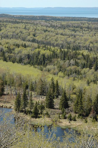
It was an odd feeling- on one hand, it's tempting to think of Isle Royale as this small place - only 50 miles stem to stern - the small eye of Lake Superior - hikable in its entirety in less than a week - smaller than almost all of the western parks. But sitting on Mt. Franklin's overlook and surveying the vast expanse below, which is only a small part of the map, it became clear just how big this island is. We forget the meaning of distances when all we do is drive - we remember again when we hike.
We returned down the Mt. Franklin trail, past the now mooseless moose lake, and hung a left one ridge earlier than the trip up, to return through the Tobin Harbour path. At this point, we were almost 8 miles in to the hike, and the trudging phase of the hike had begun, so we noticed less, save the previously mentioned differences in the forest compared to the windward side, and a few loons and mergansers. I suppose it is a good time to run down the Tuesday bird list. In addition to Monday's sightings:
- American black duck
- Mallard [oooooh]
- spotted sandpiper - at 3 mile, hopping along the pebbly lakeshore, as sandpipers are wont to do
- blue jay
- oven bird
Dinner back at the cabin was a tired affair (10 miles walking is a lot for us), and we sat and read and wrote for the evening, watching the sun go down (eventually) over our little inlet. It's really a great cabin, and a great view. I'm not sure we even managed to stay awake until dark, though. Maybe tomorrow night I'll be able to describe the stars.

Common mergansers.
Greats pics. Isle Royale is my favorite spot to spend a week or two.
Great photos of Ile Royale.
Say hi to bruce the moose.
Beautiful. Beyond gorgeous.
Homesick ;)