Politics of volcanoes
Serpentine (as known as serpentinite), the current (and potentially soon-to-be ex-) state rock of California.
This does not have a direct connection to volcanoes, but it sure is about geology and the science in the news. State Senator Gloria Romero of California has sponsored a bill to change the California state rock from serpentine because, as she claims:
"[Serpentine] contains the deadly mineral chrysotile asbestos, a known carcinogen, exposure to which increases the risk of the cancer mesothelioma ... California should not designate a rock known to be toxic to the health of its residents…
News!
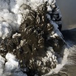
The summit crater lake at Gorely in Russia, taken on June 21, 2010. Image courtesy of KVERT.
Eruptions readers have been abuzz about how KVERT will be closing shop (yet again) at the end of June. This would, of course, leave no local monitoring and expertise in the very active Kamchatka Peninsula and Kuril Islands in Russia. Right now Shiveluch and Gorely are both showing signs of increased eruption (along with other volcanoes in the arc). In fact, Gorely, which hasn't erupted since 1986, looks primed to have an eruption, with increased tremors, steam-and-gas emissions and a new summit…
The latest news from the world of volcanoes, brought to us by the Global Volcanism Program, USGS and the Smithsonian Institution. They are also brought to us by Sally Kuhn Sennert - and if you have a question for her about her job at the GVP preparing the Weekly Volcanic Activity Report and all things volcanic (and hopefully it won't end like another recent volcanically-mitigated interview).
Some highlights (not including Gorely and Sakurajima):
Ioto (aka Iwojima) in the Volcano Islands of Japan produced an ash plume of unknown height. The volcano has frequent phreatic eruptions and abundant…
News!
Colima in Mexico erupting in 2008.
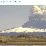
The current activity at Eyjafjallajökull is more-or-less unchanged, with strombolian activity producing a 3-4 km tall ash-and-steam plume and the lava flows at the crater moving northward towards the GÃgjökull glacier. You can check out an extensive page on the state of this eruption at the Nordic Volcanological Center - along with a new page with thermal and LIDAR information on the eruption from France.
The Icelandic Met Office notes that the lava has been producing meltwater from the glacier - which many Eruptions readers have noticed as floods…
Night image of Eyjafjallajökull erupting on April 24, 2010. Image courtesy of James Ashworth.
A quick update on the Eyjafjallajökull eruption: Not a lot to report in terms of changes in the volcanic activity at the volcano. The update from the Icelandic Met Office last night sums it up nicely:
Overall activity similar as yesterday. Eruption seen from west in the morning - north crater still active. External water has not affected vent activity much since 18 April. Geologists' field observations (2-10 km from vents) show that explosivity is magmatic and that the tephra produced since 18…
A night shot of the Eyjafjallajökull eruption showing the glowing plume from the strombolian explosions and the Aurora Borealis overhead.
A quick update on the current activity at Eyjafjallajökull eruption: the eruption continues at the summit craters, but there seems to be less ash being erupted, at least yesterday. The latest update from the Icelandic Met Office suggest that things are settling down - but floods are still periodically being produced by melting of the glacier:
Volcanic tremor has been similar the last 24 hours. GPS stations around Eyjafjallajökull showed deflation…
A strombolian eruption in the crater of Eyjafjallajökull, taken on April 19, 2010. Image courtesy of the Icelandic Met Office.
The Eyjafjallajökull eruption in Iceland has been one of the most fascinating eruptions in recent memory - and this is beyond the fact that it is a prime example of a "wired" eruption, where people from around the world can follow every aspect of the eruption from the comfort of their home. What will really be interesting is the political fallout from the six day closure of the airspace over most of Europe due to the ash. If you read the press, you'd think that…
Eyjafjallajokull erupting on 4/17/2010, image by Marco Fulle. Note the "rooster tails" of ash and steam, typical for Surtseyan eruptions.
European airspace has slowly begun to reopen as the explosive eruptions at Eyjafjallajökull have become less intense over the last 24 hours. However, there is still lots of hazardous airspace and airports around places like London and across the UK remain closed - leaving people stranded. We will still have to wait to see what the political ramification are, especially after EU officials claim "flaws" in their decision and the over $1 billion losses by the…
National Geographic film crew near Eyjafjallajökull, April 18, 2010.
UPDATE 1PM EDT 4/19/2010: I can almost categorically say that Hekla is NOT erupting, contrary to Twitter or the brief banner on MSNBC. See my comment below (#68).
In what is sounding like a bit of a broken record, the eruption at Eyjafjallajökull is still going. However, we might be beginning to see some changes in the style of volcanism - even the first suggestion of lava flows at the new crater. As mentioned yesterday, since the eruption became subglacial, we've been seeing eruptions where water - in this case glacial…
Webcam shot of Eyjafjallajökull erupting on April 17, 2010.
I don't want to get too far into this but there has been a lot of chatter about the link between melting ice caps and increase/decrease/neither of volcanism. The two main articles we're talking about are:
Scientific American, saying that ice loss could increase volcanism:Ice cap thaw may awaken Icelandic volcanoes
The long and short of the Scientific American study is that you reduce the pressure of rocks in the crust/mantle below Iceland, you generate more melting - depressurization melting of rock. If you melt the ice cap, you…
Shiveluch in Kamchatka in an undated photo.
Just a quick note, but I got this email overnight regarding the status of KVERT, the Kamchatka-Kuril Island volcano monitoring body in Russia.
Scientists of KVERT Project return to the full KVERT operations (the
information ensuring of air services for the results of daily analysis
and evaluation of activity of Kamchatka and Northern Kuriles
volcanoes) and will discharge these obligations for 01 February - 30
April 2010.
So, after losing their funding, it has some back until the end of April (based on how I read this). Russian politics as usual? A…
Bezymianny in Kamchatka, one of the many volcanoes in eastern Russia that will no longer be monitored by KVERT.
In some bad news for volcano watchers (and the general public, too), Russia has decided to stop funding KVERT (the Russian equivalent of the Alaska Volcano Observatory), the institute that monitors and researches volcanic eruptions on the Kamchatka Peninsula and the Kuril Islands in the western Pacific. Here is the news release from KVERT:
Due to a loss of government funding beginning February 01, 2010, KVERT will no longer
distribute information regarding volcanic activity in…
Gambling and volcanoes go hand-in-hand?
Somehow I didn't pick up on this, but people are gambling on volcanoes now?
I mean, I suppose if they bet on the coin toss at the Super Bowl, people will bet on anything. Now, I'm not one to judge the taste in any of this, but here are the current odds for volcanoes to have a VEI 3 eruption:
3/1 Mt Unzen (Japan)
9/1 Mauna Loa (USA)
10/1 Ulawun (Papua New Guinea)
10/1 Merapi (Indonesia)
10/1 Santorini (Greece)
11/1 Colima (Mexico)
11/1 Rainier (USA)
11/1 Taal (Philippines)
11/1 Teide (Spain, Canary Islands)
12/1 Mt Nyiragongo (DR Congo)
12/1…
Here it is, my attempt to recap a year's worth of volcanic events. By no means is this supposed to capture every event, but rather the highlight/lowlights and what most captivated me during 2009. I'll be announcing the winner of the 2009 Pliny for Volcanic Event of the Year tomorrow.
Waimangu Geothermal Valley in New Zealand, taken in January 2009 by Erik Klemetti.
January
The year started out with a trip to New Zealand (well, for me at least) and vistas of the Waimangu Valley, formed in the 1886 eruption of Tarawera on the North Island. We were also still thinking about the late 2008…
Manam in Papua New Guinea erupting in 2004
Five years ago, Manam volcano in Papua New Guinea erupted. The volcano is located on a 10-km island of the same name and when it erupted in 2004, it produced pyroclastic flows and lava flows to the tune of a VEI 4 eruption. It was decided that the 9,000 inhabitants of the island had to be evacuated but even so, five people died due to the eruption. However, there are still thousands of people in temporary care centers on the main island of Papua New Guinea. Tensions have flared with the local inhabitants, to the point that four former islanders have…
Chaiten erupting in May 2008. Image courtesy of ONEMI.
Speaking of anniversaries, this weekend is the one-year mark for the Chaiten eruption (in spanish) in Chile, the first eruption at the volcano in ~9,000 years. Yes, indeed, the rhyolite eruption that caught most everyone by surprise is still going strong one year later, with two domes growing within the caldera (in spanish). The eruption produced some of the most impressive and sustained ash columns in years (see below) - climbing to 16 km/9 mi, abundant lahars and pyroclastic flows from the emergence and growth/collapse of the domes and…
Volcano monitoring. Image courtesy of the USGS.
Last night I had the opportunity to see a talk given by YVO Scientist-in-Charge Dr. Jake Lowenstern as part of the Volcanological Society of Sacramento meeting and he gave a great talk on the state of volcano monitoring today in the U.S. He laid out a lot of details concerning the Volcano Hazards Program of the USGS and I thought I'd share some of them so we can all have an idea of the ups and downs of the VHP these days.
First off, nothing says fun like the U.S. Volcano Status Map! Apparently the dreaded watch "eye" was not meant to be a…