historic eruption
Chaiten has made it back into the news in the past couple days, both with new events at the caldera and with findings from the initial blast in May 2008. Here goes:
Chaiten erupting in 2008.
Third Dome Spotted
The latest USGS/SI Weekly Volcanic Activity Report mentions that over the last week, Chaiten experienced what was likely a significant dome collapse of one of the two domes growing in the caldera. People living close enough to the volcano to see the ash plume noticed it became larger and darker on September 29th. Afterwards, visual observations of the caldera by air confirmed that a…
As fall descends on the northern hemisphere, spring starts in the southern. Luckily for us, it means that we get better views of the southern Andes in Chile ... which means the NASA EO could train one of the many "eyes in the sky" (specifically the EO-1) on Chaiten. The volcano is still erupting, going on 16 months, since it caught everyone off guard in May of 2008. As you can tell from the image (linked and below), Chaiten is slowly filling in the pre-2008 caldera with new rhyolite dome growth - you can see that the pre-2008 dome within the caldera (see the picture taken from the ISS in 2003…
The Royal Gardens subdivision in Hawai'i being inundated with lava flows during a 1983 eruption of Kilauea. Image courtesy of the USGS.
The game of insurance is everywhere in the news these days so it isn't too surprising to run across this brief article about the perils of getting insured if you live on an active volcano. Many people who live on the big island of Hawai'i face this challenge because a large swaths of the island fall into what is called a "Lava Zone 1", which more or less means that you live someplace that lava is likely to visit in the foreseeable future. Considering that the…
Does anyone else feel like this has been a rather quiet summer, volcano-wise? Maybe I've been too preoccupied by my move to Ohio, but I feel like beyond a few relatively minor events (Shiveluch comes to mind), the volcano news has been pretty slow compared to the spring of this year. Go figure.
The sulfur dioxide plume from the 2008 eruption of Kasatochi spreading over the northern Pacific Ocean.
Anyway, a few tidbits to tide us over:
Over eighteen years after the eruption, Mt. Pinatubo is still causing fatalities from the copious amounts of tephra deposited during the 1991 event. Five people…
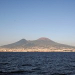
The latest in my Volcano Profiles Series, we turn to Europe and Vesuvius. You could fill many, many volumes with the works produced on Vesuvius since Roman times. This profile will barely scratch the surface when it comes to the vast geologic and human history surrounding the volcano, but it is a start. If you want to learn more about the archaeology surrounding Vesuvius, try visiting Blogging Pompeii.
VOLCANO PROFILE: MT. VESUVIUS
Mt. Vesuvius in Italy. Image courtesy of Dario Leone.
Location: Italy
Height: 1,281 m / 4,203 ft
Geophysical location: The tectonics in the Mediterranean are very…
Here's some news bits for all you volcanophiles. Enjoy the weekend!
Ubinas in Peru steaming away in June 2007. Image courtesy of Eruptions reader Mike Lyvers.
There has been a lot of press lately on the theory that a large eruption from an ancient volcanic field in China (the 260-million-year-old Emeishan volcanic province of southwest China) could be the culprit in the grand Permian extinction. I have to admit, I've only skimmed the surface of this study, but the work lead by Dr. Paul Wignall (a paleontologist, not a volcanologist - not that there is anything wrong with that) seems to…
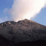
Mount Saint Helens less than 30 seconds after a sector collapse that triggered one of the largest eruptions in the Cascades in the last 500 years.
Today is the 29th anniversary of the dramatic eruption of Mount Saint Helens in Washington state. The eruption dramatically changed the landscape around the volcano along with greatly increasing our understanding of volcanic sector collapses and explosive eruptions. I was going to write a larger entry on the event, but alas, I will instead be lecturing to 100 UC Davis students about the event today instead (sorry folks!)
Instead, if you want to…
Chaiten erupting in May 2008. Image courtesy of ONEMI.
Speaking of anniversaries, this weekend is the one-year mark for the Chaiten eruption (in spanish) in Chile, the first eruption at the volcano in ~9,000 years. Yes, indeed, the rhyolite eruption that caught most everyone by surprise is still going strong one year later, with two domes growing within the caldera (in spanish). The eruption produced some of the most impressive and sustained ash columns in years (see below) - climbing to 16 km/9 mi, abundant lahars and pyroclastic flows from the emergence and growth/collapse of the domes and…
Descabezado Grande, Chile showing increased fumarolic activity in 2009.
Well, if they didn't have enough already between Llaima and Chaiten, another volcano in southern Chile has started erupting. Descabezado Grande (roughly translated: "The Big Beheaded One") has erupted or is showing of eruption (in spanish and NOTE that the picture in the article is of Llaima, NOT, I repeat, NOT Descabezado Grande ... grrr) but details are scant on the actual activity. However, scientists from the SERNAGEOMIN are headed to the area to evaluate the volcano - hopefully the reports are accurate. So far,…
Chaiten erupting on January 19, 2009. Image courtesy of the NASA Earth Observatory.
It is hard to believe that we are less than one month away from one-year anniversary of the beginning of the eruption at Chaiten (and with it, the one-year anniversary of this blog!) The volcano in southern Chile is still erupting away, creating at least 2 dome complexes within the older caldera. These domes have been experiencing periodic collapses, creating block & ash flows, some of which have made it out of the caldera and down close to the ghost town of Chaiten. Along with the block & ash flows,…
Tambora, Indonesia
There are big eruptions, then there are big eruptions. On April 10, 1815, Tambora, a volcano in Indonesia, produced one of the largest eruptions in human history. This eruption produced what became known as the "year without a summer" after the volcanic aerosols from the eruption produced some of the coldest summers in many parts of the world. The Tambora eruption in 1815 was a VEI 7, on a scale that goes to, well, 7*, putting it in a class of some of the largest and most violent eruptions imaginable - and I, for one, can hardly imagine what might happen if an eruption of…
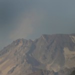
Image courtesy of USGS/CVO, taken March 8, 2005 from the Cascades Volcano Observatory, Vancouver, WA
For those of you looking for something to relax with and read this weekend, you could wander over to the USGS website and download yourself a copy (for free and legally) of "A Volcano Rekindled: the Renewed Eruption of Mount St. Helens, 2004-2006" (USGS Professional Paper 1750). The report comes in at a mere 872 pages (that's 697 MB download for the whole report), but you can download the pieces that interest you most as well instead of the whole shebang.
Now, I haven't read the whole thing,…
Mauna Loa fire fountains in 1984
For those of you looking for some non-Redoubt-related volcano news, you can take a look at the 25th anniversary of the last eruption at Mauna Loa (there is some nice video footage provided by KHNL if you follow the link). By no means is this volcano "dormant", but rather this is a typical lull in activity at the Hawaiian shield volcano. Its neighbor, Kilauea, has been erupting for decades, but the last major eruption at Mauna Loa was in 1984, when the volcano sent lava downslope with 3,000 feet of Hilo, moving 15 miles in a few days. Monitoring at Mauna Loa…
Two tidbits from New Zealand:
- A recent survey of volcanoes in the Kermadec Arc north of New Zealand suggest that there is abundant - and recent - undersea volcanism. Scientists from University of Washington (one of my former homes) and Southhampton University (UK) explored a number of submarines volcanoes including Rumble II West, Rumble III and Brothers, which are all located along the same arc of volcanoes as New Zealand's own White Island and Mt. Edgecumbe. What they found was a change in the shape of Rumble III (1.4 km below the sea surface) since the last survey in 2007 - the summit…
UPDATE 2/19/2009 9:45 AM: Well, it seems that my hunch was at least partially right. Reuters (and Paula Narvaez, special envoy to the Chilean president) is calling the eruption as result of "what appeared to be a partial collapse of its cone."Â So, we might have seen the oversteepening of the dome growing in the Chaiten caldera that lead to a collapse, producing (likely) a pyroclastic flow and either an accompanying plinian eruption as the pressure was released or an ash column associated with the pyroclastic flow itself. Now, I might not take Reuters word for it, but it makes sense…
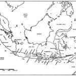
The Anchorage Daily News has an excellent article today on the Drift River Oil Terminal, a depository for oil collected from the platforms in the Cook Inlet. This oil terminal stores at least 1,000,o00 barrels of oil (see article for why we're not sure) and sits, well, at the base of Redoubt (see map below from Anchorage Daily News) on the floodplain of the Drift River (~25 miles from the vent).Â
Now, this oil terminal was more-or-less destroyed during the last episode of volcanism at Redoubt twenty years ago when the terminal was wiped out by floods resulting from the eruptions. Not only…
It is hard to believe that the eruption at seem to come out of nowhere at Chaiten started over 8 months ago now, and apparently is still not showing many signs of abating. I did get a chance to see some great talks and posters at AGU last month about the Chaiten eruption, with the key points I took away being that Chaiten is erupting a very crystal poor rhyolite (<1% crystals) and that it seems that the source of the magma is relatively deep in the Andean crust. Also, there are some indications that the eruption at Chaiten may have been tectonically instigated - i.e., that earthquakes in…
I wouldn't normally use this blog for something like this, but google has failed me. When I was in New Zealand, I saw a video on the 1995-96 eruptions at Ruapehu titled Witness to Eruption made in, I believe, 1999. It had some excellent footage of the eruptions in the 1990s as well as the 1950s, along with some great examples of interactions between the populations/businesses near the volcano and the eruption (namely the ski areas). I assumed I could get back to the states and look up the video on google to buy a copy, but no luck! Does anyone have any knowledge about where I could find this…
One of the more impressive areas I visited while in New Zealand was the Waimangu Valley near Mt. Tarawera (above). The valley itself was created by blast explosions (phreatic explosions) during the 1886 eruption of Mt. Tarawera. These eruptions cut right down the axis of the rhyolite domes (most of which erupted ~1305 A.D.) and extended off the volcanic edifice to form the valley to the west of the volcano. In the valley, no juvenile lava was erupted, instead explosions carved out large pits that formed the Waimangu Valley and today the valley is filled with lakes and thermal features (below…
I made it back from New Zealand yesterday after spending the last two weeks looking at some of the most remarkable volcanic landscapes you could imagine. I'll add more detail soon for those of you interested in the volcanism of the North Island, but I'll leave you with a picture of yours truly in from of Ngauruhoe (a.k.a Mt. Doom) along the Tongariro Crossing. The volcano last erupted in 1977 and it considering the youngest vent of Tongariro. Ngauruhoe has had >60 eruptions over the last 150 years.