Hermine
Hurricanes are well defined systems with characteristics that quite literally set them apart from other storms. Large storms such as Nor'Easters are sometimes less well defined and interact more with major troughs, the jet streams, etc. We have come to understand Hurricanes as the worst case scenario, while other storms are less dangerous.
But sometimes, and I suspect more recently lately, these non-tropical storms become quite dangerous. The Great Storm of '78 killed hundreds in New England and made us suddenly realize that coastal property was a temporary thing. But we sense the danger…
Update (Sunday PM):
Hermine is still a big storm and will affect eastern regions to some degree, but the storm never reformed as a hurricane, and is not not expected to do so. Also, the storm has jinked out to the east more than expected and will likely move farther east. So, there will be some coastal effects, but not much out of the ordinary.
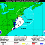
POST-TROPICAL CYCLONE HERMINE FORECAST/ADVISORY NUMBER 30
NWS NATIONAL HURRICANE CENTER MIAMI FL AL092016
2100 UTC SUN SEP 04 2016
CHANGES IN WATCHES AND WARNINGS WITH THIS ADVISORY...
A TROPICAL STORM WARNING HAS BEEN ISSUED FROM WATCH HILL…

For the latest post on Hermine GO HERE.
Update Thursday PM
Hermine has grown in strength, and may even make landfall as a Category 2 storm. At least a strong Category 1.
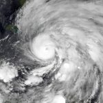
The right front quadrant of the storm is where the main "punch" (of winds) is located. If the storm winds come into an embayment, they can really build up the storm surge. Look at this image:
You can see the right front quadrant of the storm heading right into Apalachee Bay. Barrier islands to the west of the bay's head, and the communities right in the bay, are very much at risk for severe flooding.
Here is a blowup…
Original Post:
The Atlantic storms are getting interesting.
Two different systems are poised to become named storms, but it is not clear which one will be awarded the name Hermine, and which one Ian. If the storm recently near Cuba develops as expected, it could become a weak hurricane before making landfall along Florida's Gulf coast. This will not likely be a very impressive hurricane, but it will be big and wet, and the area is already experiencing too much water. Flooding will ensue.
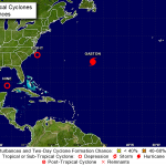
A third system is moving off of Africa, with 40% chance of forming into a storm over the next several…
A quick note about the current Atlantic hurricane season. With resect to just the US, we've had a fairly low level season, and it is easy to become complacent about this time, but in fact, the risks from Atlantic hurricanes rise about this time of year, so pay attention. Watch for Hermine. More on that below.
We are approximately in the middle of the 2016 Atlantic Hurricane Season, by calendar time. The number of named storms (tropical storms plus hurricanes) predicted for this year is about 14, taking the average of all the predictions made so far, and there have been 7 storms including…