Blizzard of 2015
What happened to the Blizzard of 2015? Well, it happened. Despite breathless complaining about how the forecasters got it all wrong, they didn't. As the storm was predicted, there should have been close to about two feet of snow in the New York City metropolitan area, but as it turns out, there was between 8 and 12 inches. That means that New York City experienced a typical winter month's worth of snow in one day. Also, most snow that falls on The City falls a few inches at a time and melts more or less instantly, as few cities can match New York in its heat island effect. So, 8-12 inches…

The Blizzard continues. The center of the low pressure system moved to the northeast more than expected, so the maximum snowfall amounts have also moved deeper into New England, and it the storm may end up dropping the largest amounts Downeast, in Maine, rather than around New York and southern New England. Nonetheless maximum snow totals are heading for 20 inches in many areas west of Boston.
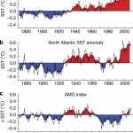
Here, I wanted to alert you to a recent study that talks about "Changes in US East Coast Cyclone Dynamics with Climate Change," which has this abstract:
Previous studies investigating the impacts of…
About 20 million people are currently under a blizzard warning, and double that under a winter weather advisory, for a storm moving into the Northeast today and tomorrow, with snow falling though Wednesday. Thousands of flights have been cancelled. Wind will be at tropical storm force, and occasionally, hurricane force, and coastal flooding is expected to be epic. The total amounts of snowfall will be over a foot for a very large area, and well over that here and there, though this is very difficult to predict.
This is a strong low pressure system that will gather significant energy from a…