Gulf Stream
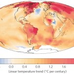
Climate scientists have noticed a disturbing pattern in the North Atlantic. This is the relative cooling of surface waters in the area fed by the Gulf Stream. This pattern has emerged over recent decades, and may portend very rapid and potentially disruptive climate change in the upcoming decades. The cooling is not subtle at all, and looks like this:
Map based on NASA GISS data of warming 1901-2013
So what does this mean? A paper out just today describes, explains, and discusses this odd anomaly and its potential consequences. First, a bit of context.
The Earth’s climate follows certain…