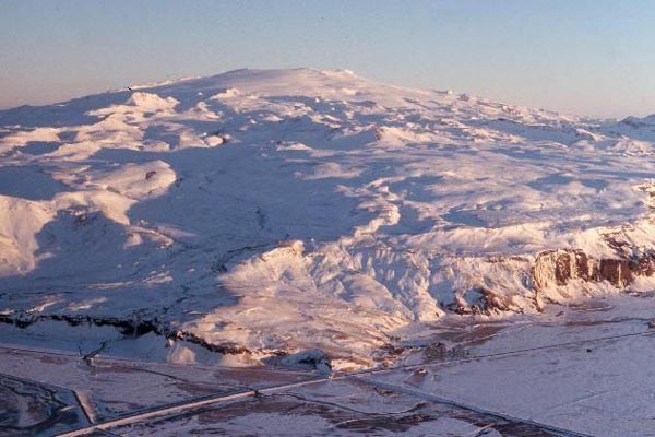
Eyjafjallajökull, an ice-capped volcano in Iceland that last erupted in 1823.
We talked a few weeks ago of signs that there were increasing signs that an eruption could occur on Iceland - increased seismicity on the Reykjanes Ridge suggested that magma might be on the move. Now, we have two pieces of evidence that we might see activity at Eyjafjallajökull, on the southern side of the island nation.
First off, there is a focus of seismicity under the area of Eyjafjallajökull, with an especially large bump in the last 2 days. Both the number and magnitude of the seismicity has been marching upwards, with the latest earthquakes reaching around M3, almost directly underneath the buried (by ice) crater of the volcano. This would suggest that something is up under the ice cap - either magma is moving in the system or the hydrothermal system is experiencing some large fluid flow event. I can't really figure out the depths of these earthquakes based on the Icelandic Met Office page, so any help with that would be greatly appreciated. UPDATE: The depths can be found by clicking the tab above the map marked "table". (Thanks to Bernd for that info.)
Secondly, from what I can gather from a Google Translation of an Icelandic article, there is also signs of inflation at Eyjafjallajökull. The article seems to suggest that the volcano has seen ~40 mm of movement/inflation to the south based on GPS measurements and that the focus of seismicity (when the article was written) was ~10 km below the surface of the volcano. (And any of you Icelandic readers, I'd love to get a better translation!) This would also suggest that magma might be entering the upper echelons of Eyjafjallajökull's magmatic system. UPDATE: It appears that the Icelandic Met Office doesn't think this is leading to an eruption (Thanks to Orri with help on the translation).
Taken together, it looks like Eyjafjallajökull is a prime candidate for the next eruption on Iceland. Eyjafjallajökull (also known as merely Eyjafjöll) is one of a series of volcano systems on the south side of Iceland, near Katla. Amongst the Icelandic volcanoes, it has been relatively quiet, with the last known eruption occurring from 1821 until 1823, with evidence for eruptions in 1612 and 550 AD. The last two eruptions have been VEI 2, with explosive characteristics - and with a volcano under a glacier, we always have the threat of jökulhlaup - glacial outburst flows triggered by the volcanic eruption. And unlike many Icelandic volcanoes, the last eruption of Eyjafjallajökull was produced silicic to intermediate tephra rather than basalt. The larger volcanoes on Iceland such as Eyjafjallajökull, Katla and Krafla have all produced rhyolite eruptions in the dominantly basaltic land - and the rhyolite magma that was hit while drilling last year shows that you can get very silicic magmas even in a hot spot/mid-ocean ridge setting.
{Hat tip to Dr. Boris Behncke and Mattias Larsson for info in this post.}
The article says that the GPS measuring device in Ãorvaldseyri (close to the volcano) has moved 40mm to the south, wich points to some inflation in Eyjafjöll. It also says that the speed of the inflation seems to be less this week than it was the week before. It also says that a scientist at the Icelandic Met disagrees with you and does not think that the recent activity indicates an imminent eruption.
Thanks for the information, Orri. Sounds like there is some disagreement about what is going on at the volcano - makes it even more interesting to watch how it unfolds.
You can easily get the depths if you click on "table" at the top of the map.
Meiby some of you have alredy seen this, but there is a Icelandic blog by Jon Frimann where he gives information and updates about the Eyjafjallajökli activity.
http://www.jonfr.com/?p=3491
Oh wow, thanks Bernd. I completely missed that tab, but sure enough, there is all the depth data one would need.
Obviously I don't know about the characteristics of these earthquakes, and I am not too familiar with the volcano itself. And what is also true is that the last eruption took place in 1821-1823, long before the beginning of anything like volcano monitoring. But if we saw a similar activity at Etna, we'd certainly heighten our attention.
On the other hand, it seems highly unlikely to me that this is all due to glacial movement. In such a case we should see similar activity at all glacier-covered volcanoes every now and then, which we don't. That, and the observed ground deformation - not only this time, but also during earlier episodes like in 1994, 1999 and 2009 - indicates that this seismicity is due to the movement of magma within the feeder system of the volcano. We all know that in most cases such movement does not immediately lead to an eruption, but sometimes it does happen. So I'd say, this situation is not frightening, but certainly interesting.
That blog indicated by Mattias Larsson (comment #4) is quite informative - if you somehow can make sense of the Icelandic. I found a pretty good translation site, which is "www-dot-stars21-dot-com-slash-translator-slash-icelandic_to_english-dot-html" (I avoid placing links here, so maybe this comment will go through without having to bother Erik). Not 100 per cent perfect (which is impossible) but reasonably good. What I gathered from the last entry in Jón FrÃmann's blog is that during the past 48 hours there have been about 500 earthquakes, most around magnitude 1, and showing little change in depth. He concludes that "currently is no evidence that volcanism is going to get in Eyjafjallajökull. it may even change with short notice if the dynamic is to break the surface soon offer in Eyjafjallajökull." So there you also have a sample of the quality of the translation.
How exciting is this!
And reminds me of my favorite movie, "Eric the Viking",
when the villigers are saying "NOT sinking!" as the town
goes down. Politics plays a lot with information.
However, they do know their volcano and let's hope
people are safe. When these under ice volcanoes erupt
the results are spectacular.
Best!motsfo
I got pointed to this blog by a email. The current signs of activity in Eyjafjallajökul point to increased possibility of a eruption. A person how I did speak to about Eyjafjallajökull told me that there has been 1000+ earthquakes in last 24 hours. This activity started yesterday. But there was a peak last week also, that was an early indicator it seems.
The current activity in Eyjafjallajökull is continues at the moment. Gas and water vapour is possibly escaping from the magma chamber at the moment. The volcano is problay just clearing it's magma tube at the moment, to the top crater.
I rum the amateur station near the Hekla volcano. It is located ~40km away from Eyjafjallajökull.
I forgot. Here is the english old web page of Icelandic Met Office.
http://hraun.vedur.is/ja/englishweb/index.html
Interesting NW-SE trending indicated on the EQ map this morning.
A logical explanation (if glacial seismicity is not the cause) for these swarms may be found in this Summary of Previous Seismological Findings (2001), echoed in later citations I posted yesterday:
"As one proceeds from the Reykjanes Ridge, across the Reykjanes Penninsula and into the neovolcanic zones of Iceland, these AVR's gradually blend into Iceland's volcanic systems, which retail the same general en echelon form, but on a larger (50-100 km) scale. Each of these systems is composed of a central volcano and an associated fissure swarm. The upper crust of Iceland is formed when magma from the shallow (3-4 km) crustal magma chambers (Brandsdottor et al. 1997) of these volcanoes intrudes into the fissure swarms during lateral diking events (which are accompanied by numerous earthquakes in the upper 5 km) (Einarsson and Brandsdottir, 1980). "
Source: Reykjanes Ridge Seismology
http://www.ldeo.columbia.edu/users/menke/ridge2000.html
Yo! Check out the two webcams of Chaiten! Somethings up. The first camera image showing a minor lava spray, dates from 1:30am this morning, and it hasn't updated. The second one, currently broadcast from the nearby town, shows a strong plume emission.
Maybe we got an eruption in progress.
a silly question:
isn't rhyolite the product of molten continental lithosphere?
Where's continent here? I thought Iceland was all MORB?
@ Passerby. I may be mistaken, but as far as I can tell Chaiten volcano bears NNE from Chaiten airport which means the volcano is not in the field of view of the cameras.
@13 Bruce,
not a silly question at all. One way to produce rhyolitic/granitic magma is by fractionation in a basaltic magma. If a basaltic magma sits at the base of the crust olivine and/or pyroxene will crystallize and remove relatively more MgO and FeO than silica from the system, as a result some of the remaining liquid will be enriched in silica to the point that it becomes rhyolitic. Not only can this lead to an eruption of rhyolite, but over time repeated creation of silicic magma can also produce granodioritic crust when it solidifies at depth. Future basaltic magmas may assimilate some of this and become more silica rich by this method as well. Together, these processes are why rift zone and hotspots under continents are "bimodal" with regards to the magmas they produce.
@Comment 13
Iceland is located both on the Mid-Atlantic Ridge, and also on a hot spot. Without going into too much detail, it seems like the interaction of the two allows for magma evolution in Icelandic volcanic systems.
Generally speaking, mature Icelandic systems comprise a central volcano plus fissure zones extending from 2 opposite sides (usually parallel with the plate boundary). The central volcanos are located more or less directly over the lithospheric magma chamber.
There is a lot of debate over how exactly the process happens, but it seems that the magma in the shallow chamber evolves somewhat. The more felsic magmas then tend to be erupted from the central volcanic edifice, and the basalts, although they can occur anywhere in the system, often give rise to the spectacular fissure eruptions that Iceland is so well known for (recently, eruptions such as the subaerial Krafla fires or the subglacial Gjalp eruption).
Basically, the bulk of the magma erupted in Iceland is still basaltic, but more silica-rich magmas are found in the central volcanoes. There are also a few lava domes visible in Iceland, although I do not know a great deal about these - it has even been proposed that a cryptodome lies in the area between Katla and Eyjafjallajokull, which could lead to some interesting activity if, say, a basaltic intrustion from Eyjafjallajokull were to come into contact with it.
I've been watching Eyjafjallajokull daily for a few months now and this is easily the biggest swarm of activity I've seen. Coupled with the GPS data showing steady inflation, and occasional low-frequency tremor measured in the area, it's a pretty compelling story to follow.
I should also say that all of this data - seismic, tremor, GPS, even tilt meter data - is available on the Icelandic Meteorological Office website. You just have to dig around a little to find it, sometimes.
Yes, Eyjafjallajokull seismic activity has accelerated rapidly If one clicks on the Tremor link, left hand pane, you can see the graphs showing significant uptick in seismometer readings at many nearby stations, including those trending towards the NW and South. For an example, click on the offshore station, see what I mean?
Areal extent is rather larger than casual intrusion. So perhaps something bigger is afoot.
Camera 1, showing Chaiten lava ejection early this morning:
http://www2.sernageomin.cl/ovdas/ovdas7/webcam_chaiten.html
Camera 2, showing continued gas eruption at present:
http://www.aipchile.cl/camara/location.php?locationID=34&cameraID=116
A jökulhlaup is a very impressive phenomenon, transporting house-sized ice blocks long distances and essentially annihilating anything standing in its way. If you are familiar with the "scabbed lands" in the American northwest, this feature was created in a few hours when a glacial dam collapsed, creating the mother of all jökulhlaups as a great lake was drained. -Actually, similar jökulhlaups may have recurred at or near the site during several glaciations, but glaciers tend to erase the traces of what came before them....
I hope the geologists will rig up cameras so any jökulhlaup at Eyjafjallajökull can be monitored in real time from the beginning.
@EKoh and James:
wow, this looks pretty interesting!! (I can't see me getting much more work done tonight .. Ha!) thanks! Great stuff.
The Volcanism blog cited an AGU Fall 2009 meeting abstract,
'Magma ascent at coupled volcanoes: Episodic magma injection at Katla and Eyjafjallajökull ice-covered volcanoes in Iceland and the onset of a new unrest episode in 2009'
Second to last sentence: 'To interpret the observations, we consider influence of several processes, including: seasonal ice loading, long-term thinning of the ice caps, magma migration and seismic activity.'.
Did anyone attend see this presentation? Perhaps one of the authors might weigh in here and discuss their findings.
I live in the Scablands area of the PNW mentioned by Birger (comment 18). We (myself and other scientists) examined deposits, counting as many as 40+ layered scour deposits at various locations in the Columbia Basin. Large-scale ice dam failures were a cyclic, periodic flooding event in Channeled Scablands of north-central WA (Grant County) and not a single catastrophic event.
With all the talk about Iceland's volcanoes, this is just a bit of a no news item, but at Mammoth, they have had two quakes measuring 1.9 in the area. This is a bit more than most of them so I am watching to see if there is anything bigger to come. Most likely they are techtonic. The quakes keep happening, but there isn't much to discuss...yet. :-)
@Passerby, was there a single event that was what you would call THE major event and much larger than any of the others in the Scablands? I have heard there was, in addition to the other events you mention.
@ Diane, Comment 21
See: 'Flood Stratigraphy', Channel Scablands:Overview webpage
http://www.uwsp.edu/geo/projects/geoweb/participants/dutch/vtrips/Scabl…
See also: USGS, CVO Circular
Glacial Lake Missoula and the Missoula Floods
http://vulcan.wr.usgs.gov/Glossary/Glaciers/IceSheets/description_lake_…
The activity in Eyjafjallajökull shows no signs of stopping. It is also interesting that there are deep earthquakes appearing, according to the automatic SIL system that IMO runs.
Today there have been 2000+ earthquakes in Eyjafjallajökull.
I posted this yesterday but didn't get an answer from anyone so I am trying it again:
Did I misunderstand something or are Katla and Eyjafjallajökull part of an approximately 10-km wide and 700 m deep caldera under the Myrdalsjökull ice cap?
http://www.acsys.it/volume/php/home.php?&id=8
Posted by: Randall Nix | March 3, 2010 3:05 PM
I think the caldera you talk about Randall is the one under Myrdalsjökull that belongs to Katla.
The caldera can be seen at the Icelandic Met office page.
http://en.vedur.is/earthquakes-and-volcanism/earthquakes/myrdalsjokull/
Eyjafjallajökull also has a caldera as I understand it, but it is situated under Eyjafjallajökull glacier and is about 2.5km in diameter. This info is according Global Volcanism program.
http://www.volcano.si.edu/world/volcano.cfm?vnum=1702-03=
http://www.volcano.si.edu/world/volcano.cfm?vnum=1702-02=
Randall Nix, Mýrdalsjökull and Eyjafjallajökull are two diffrent volcanoes. Eyjafjallajökull is a diffrent glacier then Mýrdalsjökull. I hope that this answers your question.
Somehow I think this is more then just ice movemenet since it is farly deep down and seems to be getting more intense by the day and hour. And why are the volcnoes of Iceland being monitored by meterologists or weather people? It is not normally there field of study.
Randall, according to The global volcanism program:
The 10km wide and 700m deep caldera is situated under Myrdalsjökull and belongs to Katla.
Eyjafjallajökull to the west of Myrdalsjökull has a 2.5 km wide caldera situated under the Eyjafjallajökull glacier. But the volcanoes are close and may have some conection as I understand it. According to Swedish wikipedia it was noticed that both Katla and Eyjafjallajökull erupted simultaneously in 1612. Also, when Eyjafjallajökull stopped erupting in beginning of 1823 it was followed by an eruption at Katla later in the same year.
Chance, Japan is the same way--the Met office monitors volcanoes.
Mattias Thanks, I saw where they may be coupled in another paper and it had sounded like they might be part of a larger caldera.
Chance Having the weather office do it sounds about right since any kind of forecasting be it weather, the economy or volcanoes is really just good intuition based on science;)
If you access the Iceland Met Office Mission page, and run it through Google Translation, you'll get your answer.
http://en.vedur.is/about-imo/mission/
Jon thanks for the info.
True but would you want a ear doctor to be doing your heart surgery, probably not. The point I am trying to make is it is not their area of expertise.
@Passerby, thanks for the sites. I have read one and part of the other one (which I will get back to)and I really liked the pictures which gave me an idea of the area. I have not been in that part of Washington and had no idea of what the floods had done and that there was so much basalt in the area. Interesting stuff.
Chance I know I was really just messing with you;) I am sure they are only reporting whatever data they are given.
@Diane, a bit more reading.
Columbia River Flood Basalt Province, Idaho, Washington, Oregon, USA, Oregon State U
http://volcano.oregonstate.edu/vwdocs/volc_images/north_america/crb.html
i kinda thought so. The swarm shows no sign of letting up Ever heard of a -0.2 earthquake? I was not aware the scale went any lower then 1 let alone in the neagatives. There are a couple of including a -0.0 which mathemmaticlly is impossible as 0 is neither negative or positive. some of the data seems a bit fishy. That quake magntide of 0 means no earthquake I would asume.
Volcan villarica is showing mild eruption activity tonight.
http://www2.sernageomin.cl/ovdas/ovdas7/webcam_villarrica.html
other webcam is showing similar activity as well.
That's two Chile volcanoes erupting today, with not a peep out of any of the monitoring folk or VAACs.
Earthquakes continue in Eyjafjallajökul and the activity shows no signs of stopping.
(Just posted this on The Volcanism Blog, too):
I have it on good authority that scientists from University of Iceland will be meeting with officials from the Civil Defence Authority (or whatever the Icelandic equivalent is called) today, specifically to discuss Eyjafjallajokull. Iâm not sure if the Icelandic Meteorological Office are also involved, but itâs probably likely.
It certainly seems that the government are now beginning to take this quite seriously.
It is also important to note that since the volcano in question hasnât erupted since 1823, no-one is really sure what to expect here. If an eruption occurs, it could be a mildly explosive but predominantly effusive eruption (similar to the Hekla eruption of 2000, for example, where an early sub-plinian phase gives way to fire-fountaining), or given the fact that itâs a central volcano with more evolved magmas, there is always the possibility that the eruption could be more explosive, involving rhyolite magmas. Of course, likely being sub-glacial, water-magma interaction would probably be in effect too. Certainly itâs somthing of an open book, and so a lot of caution will be exercised early on should an eruption occur until it is determined what exactly is going on.
Added to the distinct possibility of a jokulhlaup occuring, Eyjafjallajokull isnât a volcano to be taken lightly, and it will be interesting to see how this pans out.
@Comment 36:
Chance, yeah, a lot of the data is unrefined. If you click the 'Table' tab above the map (presumably where you are getting the magnitude data from in the first place) then you will see a 'Quality' column. Data above about 90 is pretty reliable, but a lot of these are lower (some of them as low at 30 or so). Basically these are located by the automatic system, and have not been vetted by a living scientist.
The larger quakes are usually checked and the data refined and updated. For example, there was a 3.1 yesterday which was later refined down to a 2.9 magnitude quake. Another M>3 quake today, which is interesting, and is good-quality data.
Something to keep in mind. I wonder about the diffuse activity spread over a wide area, going out even past Katla. I struggle to believe that this is all tied to Eyjafjallajokull, but I've never seen earthquakes in these locations before, and especially not this frequently. I suspect maybe a lot of these are inaccurate and should be located closer to Eyjafjallajokull itself, but there are so many of them that they can't possible vet them all one-by-one, and instead cherry-pick higher magnitude movements (maybe M>1 or M>2).
Well, it certainly is exciting but we've seen a lot of earthquake swarms before that haven't resulted in an eruption so let's see. Some of the recent quakes really are quite shallow (2 km) and the RSAM plots show the typical rise you'd expect before an eruption. I wonder if the scientists have other more local signs that we don't know of that would indicate magma is nearing the surface.
BTW here is the link for one of the RSAM plots:
http://hraun.vedur.is/ja/oroi/esk.gif
Note that the tremor graph is only showing a rise in high-frequency earthquakes. Magmatic quakes will usually be low to medium frequency, and therefore will show red or green-tipped spikes (note that distant earthquakes also show up this way - see the Chilean quake on 27th Feb!).
All the increase in blue, high-frequency activity basically just correlates with the earthquake map and table. It's low-frequency volcanic tremor that you want to be on the lookout for.
And yes, certainly this could simply stop as an intrustion. However, it seems like earthquake is much more intense than during previous intrusive events, and to my knowledge a much bigger deal is being made of this (with government meetings, etc) than the previous intrustion in 2009. I'm not saying an eruption is a certainty, but I would say it seems more likely than during previous events.
I should be able to speak to two seperate volcanologists/geophysicists from the University of Iceland face-to-face this afternoon and so I will find out what I can "straight from the horse's mouth", as it were.
cool stuff james!
Erik Klemetti, I enjoy this very informative blog daily. Thanks. Diane, appreciation for all the info on the Washington Scablands. Great for hiking prep.
Civil Defence Authority in Iceland has declared a level of uncertainty over Eyjafjallajökull. There currently is a strong wind in the area, and that might be limiting the sensitivity of the seismometers in the area and masking small earthquakes.
Yup. Lot´s af activity now and the Met says it may or may not erupt (how brilliant is that?!?), as opposed to earlier statements that it probably would not.
A similir increased activity/inflation thing happened in 1999 without an eruption but it seems this might actually be it.
I hope it erupts. Volcanos are cool.
Jón - Interesting information. What's your source on the Civil Defence's statement? I haven't been able to find a website for them from cursory Googling.
Do you know if the strong winds might also be the cause of the scattered earthquakes in the area (i.e. the ones not more or less directly centred on Eyjafjallajokull, or part of Katla's relatively 'normal' activity)? Are they down to inaccuracies in the automatic location software used to process the seismometer data? Or are they actually occurring there and somehow tied to Eyjafjallajokull, or otherwise? They've really been puzzling me.
Well judging by the high frequency signal (lack of a pronounced low frequency signal) and the wide scattering of the activity (albeit with a strong focus on Eyjafjallajokull) in a rift zone, I'm going to put my money on this being tectonic activity.
@ James the New Zealand seismograms are good for seeing the effect of wind and weather. It comes up as constant noise that looks a lot like long-period tremor if you don't know what is going on. I highly doubt wind or waves could cause a typical earthquake signal.
James, you can find the announcement here, http://www.almannavarnir.is/displayer.asp?cat_id=8&module_id=220&elemen… and here, http://www.almannavarnir.is/displayer.asp?cat_id=409
It is in Icelandic. The current status of Eyjafjallajökull is not good in my opinion. The earthquakes appears to have dropped, but the weather is worse then yesterday so it might be masking many small earthquakes in Eyjafjallajökull.
@Bruce:
I'm not sure it's just tectonic movement. Eyjafjallajokull and Katla are at the south end of the rift zone (Vestmannaeyjar forms the very southernmost tip, although it is propagating slowly further south), sort of off the main rifting area. I've been watching it for months and I've never seen this kind of activity in the area - both the area and the amount of activity seem unusual.
If you are saying that ALL of the activity being seen here is tectonic then that's far from the truth - there are definitely magma movements, as shown by the inflation of the volcano, the degassing event about a month ago (which caused an acid flux into the water supply to Vestmannaeyjar), and the pattern of seismicity over the past few months.
As for wind interference, weather oftens shows up as high-frequency on the Icelandic tremor graphs. You can see storms roll in and pass over just from looking at those charts - it's pretty interesting. I'm not down on the south coast right now (I'm in Reykjavik) so I can't say what the wind is doing, although it sounds as if they are fairly strong.
Jon, has the low frequency signals that start to develop at Hekla seismic station anything to do with Eyjafjallajokull? Or is just local signals from Hekla, or meiby the gale winds causing vibrations?
Meiby you gave the answer to my question before it was told James ;)
@Matthias:
Unless Hekla is within an hour of blowing up (unlikely), it's not magmatic movements within that mountain. It remains almost totally aseismic until magma ascends from the shallow magma chamber to the surface, giving perhaps an hour (at the most) of warning before it erupts.
On the one hand, this makes Hekla pretty dangerous. On the other hand, once that tremor begins, it makes it amazingly easy to predict - in 2000, the eruption warning issued was accurate down to about 5 minutes, if I remember correctly.
@ James - I'm just wildly guessing! I don't know squat. I've followed a lot of earthquake swarms below volcanoes in the last couple of years, none of which came to an eruption (apart from Redoubt and even she took her time). Let's wait and hear what the experts think. The inflation and degassing are certainly pretty good signs something is up on the magma front.
I'd also love to know if this kind of activity is symptomatic of stoping and fault propagation if any of the experts here want to chip in.
@Bruce:
I've been kept up to date by two such experts right here in Iceland, particularly concerning this volcano, over the last couple of months. I'm basically passing on what I've been told by them, as it happens (see the posts about Eyjafjallajokull over on The Volcanism Blog).
Certainly there is little doubt that an intrusion event is underway under Eyjafjallajokull. The theory a month or so ago, as the earthquakes began to propagate laterally to the south-east from the central caldera, is that it was forming a horizontal sill structure. The only real question is whether it will stop as an intrusion, as it did in 2009 for example, or if it will reach the surface. This increased seismicity is unusual, and somewhat different from the previous intrusive events witnessed here, which is why everyone is now so interested in it.
It's interesting, too, that the earthquakes now seem largely focused above the central caldera once again, rather than following the assumed path of that sill. Perhaps the sill has propagated as far as it will go, and magma is now moving upwards through the main conduit? I'm honestly not sure.
Disappointingly I couldn't really get any face time with either of my two contacts at the university this afternoon, so I'll have to go with what I was told briefly by one of them this morning (about 9am), which was that seismicity has increased a lot and that the focuses have been getting progressively shallower. He also called it 'a crisis' but he's a pretty enthusiatic guy so I wouldn't read too much into that. Nothing really new there, but it is from a source about as close as you'll get to the 'front line' of this.
anthropogenic agreement gases alternative business stories
@Pyromancer76, glad you like the info on the Scablands. It was Passerby who provided the info and I have found it interesting reading.
I have a hard time leaving this blog. I wait for the next post to see who will post and what. :-)
It seems to me that if Katla and Eyjafjallajökull are coupled and Katla is a 11 x 14 kilomters wide caldera then this could get very interesting.
Katla is 'overdue' an eruption as well, statistically. It's had, on average, 2 eruptions per century, and the last was in 1918 (plus a possible very small one in 1999). Statistics aren't great when it comes to forecasting or predicting volcanic eruptions, but coupled with the slow inflation of Katla over the past few years, it would be poor to say that there is zero chance of an eruption.
There is also a cluster of seismic activity about midway between the Katla and Eyjafjallajokull calderas, in the Godabunga area. One explanation for this is that a cryptodome is present beneath this area. I sent a lot of this information into The Volcanism Blog and Ralph posted a pretty in-depth article about the two volcanoes yesterday, which is worth checking out.
There are a few possibilities here, really. Assuming Eyjafjallajokull erupts, then:
1 - Eyjafjallajokull could erupt, Katla does nothing.
2 - Eyjafjallajokull erupts, triggers an eruption at Katla within a relatively short time frame. Most activity at Katla is basaltic, but it is capable of producing rhyolites, and again it is statistically 'overdue' a rhyolitic eruption. If a rhyolitic eruption were triggered on Katla, it could be pretty major.
3 - Magma, especially basaltic magma, intruded into the flanks of Eyjafjallajokull comes into contact with the cryptodome (if one is present). Hot basaltic magma pushing a sudden influx of heat into cooler, gas-rich silicic magma in the dome could possibly produce explosive activity between the two calderas.
Again I should point out that no-one really has any idea what to expect here. It's not certain if there is a link between Katla and Eyjafjallajokull, although it seems quite likely (the link would be mechanical rather than chemical, however, since the eruption products of the two volcanoes are chemically quite different). It's not certain if there is a cryptodome present beneath Godabunga - it's just a theory to explain the seismicity between the two major volcanic edifices.
And no-one is sure what an eruption at Eyjafjallajokull might actually be like, because it last erupted in 1823. It could be a relatively mild effusive eruption, or it could be a more explosive eruption with rhyolitic products. Until something happens, it's an open book, really.
My earlier comment is still in the mod quene. However, the information from the Civil Defence Authority can be found here.
http://www.almannavarnir.is/
@James, thank you for your input. Having someone right there at this time couldn't be better. I know you are not right at Eyjafjallajkull (boy is that a mouth full), but you are near and can let us know what is going on first hand. It is getting to be one of those "sit on the edge of your seat" things. I am not talking about some catastrophy, either. I just mean it is one of the things that could go either way and it is like the people who were watching Jupiter when Comet Shoemaker-Levy was about to hit the planet---anxious anticipation, in addition to wonder.
It would be better for them if it doesn't erupt, but it would be interesting to see what kind of eruption it would produce if there is one. I think waiting to see what happens is the hardest part of volcano watching. Then there is the element of surprise. Watch out for that one. It gets us every time with quakes.
If the Krafts were still with us, would they have gone to Chile or Iceland? My impression is that they had an uncanny knack for predicting where an interesting eruption would occur.
@Diane:
No problem - and you're right, it really is pretty gripping! I know I'd like to see an eruption because that's a lot of the reason I chose to come to Iceland for a year!
I don't think an eruption at Eyjafjallajokull, even a rhyolitic one, would do too much damage. The likely following jokulhlaup could well damage Route 1 (the circular road running all the way around the country), quite possibly washing away any bridges in the way, but they tend to be rebuilt in short order. Even if Iceland is currently in an economic crisis...
An eruption at Katla could be a different matter. The jokulhlaup produced by that could possibly flow into much more densely populated areas - it hasn't happened that recently but there are definitely flood deposits showing that it could happen. Also if it was an explosive rhyolitic eruption, I'm not sure what the consequences for the population in the area could be. The Icelandic authorities have excellent evacuation plans for these eventualities, but still there are people spread out all over the area and it would take some time to reach them all.
Anyone here an actual seismologist? If you are please look at these.
http://quake.utah.edu/helicorder/yft_webi.htm
http://quake.utah.edu/helicorder/ymr_webi.htm
http://quake.utah.edu/helicorder/ymv_webi.htm
I want to make sure they are just S waves from a distant quake and not something else.
Ok I am trying this one more time...maybe it won't hold my post this time. Just add www. to the links.
Anyone here an actual seismologist? If you are please look at these.
quake.utah.edu/helicorder/yft_webi.htm
quake.utah.edu/helicorder/ymr_webi.htm
quake.utah.edu/helicorder/ymv_webi.htm
I want to make sure they are just S waves from a distant quake and not something else.
Diane I left you a post about gold panning in the "Ask Alan Boyle" thread;)
I have added all known web cameras located close to Eyjafjallajökull to my web page that I have. But I have a geophone (4.5Hz) at 40km distance from Eyjafjallajökull (~10km from Hekla) volcano.
Now I think that this is just a question of time, rather then when Eyjafjallajökull starts erupting. As this earthquake swarm has been going on since Wednesday when it started rather small in size. It also appears to be getting more shallow as the time passes. The rate appears to be 2 km every 10 hours or so, by my crude observation about the earthquake swarms.
@Jon:
Hah, I have a feeling it may go too. Nothing substantial to back that up, but a good old gut feeling. I have a 1000ISK bet with a friend riding on it going in the next two weeks, so I hope it does!
You're ideally placed for Hekla too, then! In all the excitement about Eyjafjallajokull (can we please begin abbreviating this thing?!), I'd almost managed to forget about Hekla. We shouldn't forget that the pressure within Hekla is estimated to be well above that immediately prior to both the 1991 and 2000 eruptions, and going on it's fairly regular 10 year cycle since 1970, it's certainly not unlikely that it could also erupt pretty soon. I know volcanologists here at the University of Iceland had bets on it going around Christmas time, but obviously that didn't pan out...
On the one hand, I hope it goes sooner rather than later because I don't want to be stuck nearby during the opening plinian/sub-plinian phase of a Hekla eruption when I'm working there in June. I'd rather not spend the entire time looking at it for fear of the damn thing blowing up literally in my face. On the other hand, I hope it waits until after I've finished, because I don't want it to cover the flows I'm supposed to be mapping!
Jon thanks man for the info...nice to have someone close by who speaks Icelandic....Hey are you getting some nice auroras lately? A pretty strong solar wind stream is hitting the Earth's magnetic field now so there should be some really nice ones.
@Jon:
Could you explain exactly what we're seeing on your helicorder readings? In the last day or so the vertical chart is showing more or less constant noise - is this just wind interference, with the bigger 'pulses' being actual seismic events (mostly at Eyjafjallajokull)? Or is this a constant tremor that has begun in the last 24 hours or so (if so, I haven't heard anything about it)?
I'll be keeping an eye on your page, anyway. Should be cool to keep track of in case of a Hekla eruption, too!
Hi there.
Very interesting stuff. I'm sort of planning to run away from everything at home and get on a plane whenever something "blows up" in Iceland next time. I'm a geologist/volcanologist who wrote my master Thesis on a pyroclastic rock ( Thorsmörk Ignimbrite) found in the Thorsmörk Area north of the Eyjafjöll volcano. - This originatet from the nearby Tindfjallajökull volcano and may very well represent one of the most explosive eruptions ever in Iceland.... thought to have occured around 55.000 years ago. Exiting to see what (if anything) Tindfjöll will come up with.
Seems to be less earthquakes at this time but that could change.
I was just going to post the same comment. I'm unsure as to whether it's just the wind masking the earthquakes, though, as has been mentioned earlier - certainly the wind has picked up quite a lot here in Reykjavik, and the IMO site is showing windspeeds of 17 m/s in that area at the moment.
I had also noticed that almost all of the new earthquakes are showing up very tighly packed within the caldera, rather than being spread out. I'm not sure what this means, exactly.
I've read somewhere that Iceland experiences a volcanic eruption at least once roughly every five years on average. Wasn't the last eruption in Iceland back in 2004 (which was a subglacial one at Grimsvotn)? Which brings me to this: are we overdue, or has Iceland been known to go a lot longer than 5-10 years between eruptions during historical times?
Are there any thermal anomalies and their manisfestations (warm/hot ground, unusual snowmelt and/or high water runoff from glaciers, steaming, etc) being reported as of yet at Katla or Eyjafjallajokull or even Reykjanes?
@Mike:
I believe the average interval is closer to 3-4 years. The last eruption was indeed Grimsvotn in 2004, yes. Going on that, we are well 'overdue', but it is really folly to speak in such terms - for a subject as complex as volcanology, basing even cursory forecasting on very short-term chronological patterns is tremendously inaccurate.
There are a few areas of interest right now:
- Eyjafjallajokull, which is showing all of these signs we are currently watching
- Katla, which has been steadily inflating and is technically 'overdue' on its own timescale of approximately 2 eruptions per century (the last major one being in 1918, one small one possible in 1999 following an Eyjafjallajokull intrusion event)
- Hekla, the pressure within which is currently higher than it was prior to either of its two previous eruptions, and is 'due' to erupt based on it's pattern on one eruption almost exactly every 10 years since 1970 (1970-1980-1991-2000-????)
- Grimsvotn - 'Overdue' an eruption given its past time pattern, might possibly be triggered by a jokulhlaup of meltwater from underneath Vatnajokull which releases pressure overlying the magma chamber - there has been increased seismic activity in this area within the last couple of weeks, too
- Uppytingar (spelling?) - An intrusive event took place here fairly recently, intruding a dipping dyke, and there is still notable seismicity in the area
If I had to put my money on the three most likely to erupt within the next 6 months, I'd say Eyjafjallajokull, Hekla and Grimsvotn would probably be my picks, based on the information we have and, most likely, a little bit of personal bias somewhere in my head!
As for increased runoff at Katla or Eyjafjallajokull, I've certainly not heard anything. Most likely the water would accumulate to form a subglacial lake which would then be released in one event due to a sudden pressure release, causing a jokulhlaup to flow into the lowlands.
For an example of this, look at Grimsvotn in 2004. Grimsvotn has a fascinating lake system actually. It's actually thought (as I hinted above) that a subglacial lake builds up due to geothermal activity in the Grimsvotn system, a failure within the glacier occurs and water rapidly moves away from Grimsvotn, and the sudden removal of weight from above the magma chamber and therefore decrease in pressure actually causes the eruption.
Usually jokulhlaups are considered to be a product of the eruption, but in Grimsvotn it may be quite the opposite. I'd imagine this will be studied in great detail when Grimsvotn next decides to erupt.
@James, it is the wind. There is currently a low pressure system passing in part over Iceland creating strong winds in this area and others in Iceland. My geophone picks that up and it appears as constant noise on the helicorders.
@Randall Nix, aurora activity has been low as usual due to lack of sunspots and solar storms etc.
The earthquake activity continues and shows no signs of stopping. A strong wind in the area is preventing detection of some earthquakes by the IMO SIL network if there wind noise is high.
So there are probably a lot more earthquakes then are showing up? I notice there seems to be a time delay of around 10 mintues on earthquakes rght now. Everytime I look at the table it shows earthquakes that have occured roughly 10 mintues ago. Must be trying to determine the wind from earthquakes.
There's a long cycle and a short cycle. On a few occasions Hekla and Katla did "pop" together (as in all likelihood, for instance, in 1159 BC when Hekla exploded in a 5+ possibly in response to a mid-Atlantic impact event of some kind).
My understanding from Armann Hoskuldsson, and from reading the papers of jönkuhlhaup history for Katla is that about 1 in 8 exits from Eyjafjallajökull, with the bulk (because they are created by the main caldera) exiting towards Myrdallssand. So this is likely to be the rarer kind, with the less dangerous outburst flood. The greater danger is if (in my opinion) this becomes an eruption that links with the pent-up energy not released in the "false-start" 1999 eruption.
The posters who conjecture that there's several possibilities here (esp. James, above) who posit the possible linkage to a large cryptodome, might also play with this additional outcome. If pipes form leading through opening-up fissures to a cryptodome (which we may be seeing open up right now with these shallow quakes)... rather than move the centre of the "release" toward the Katla caldera, these may guarantee the opening of magmatic pressure up and still in the SW (if it exists) caldera of Eyjafjallajökull. Depending upon the pressure below (which historically has both short cycles and very long cycles) some releases from this overall complex can be moderate... still damaging... and others can be enormous, not seen often.
I just wondered aloud... who out there might know the geologic strata well enough (about the outside south-easterly face of Eyjfjallajökull) to know how stable it is? Could sufficient eruptive forces in that relatively enclosed area cause slope failure, for instance, if there was a serious outward pressure-blast? If so, a jönkuhlhaup might be the least of our problems, yes?
How do you pronounce this in English.
Eyjafjallajokull ?
@James, just call it Eyjaf. We will know what you are talking about. :-D
good question what does he name mean in Englsih. seems when you translate some tihngs form Icelanic into Englsih the grammar gets meesed up like the blog in Icelandic on what is happenig right now with the volcanic By the way some of the quakes now are very shallow at 1 to 2 km in depth. I even see one that has a depth of 0 but that can't be right.
@Chance:
I think the map is only updated every 10-15 mins anyway. What appears on there, especially at this time of night, is going to be computer-located stuff. Many of the quakes are then sorted through and checked for accuracy by actual humans, who might then refine the published data a little. Hence why you see M>3 quakes becoming M<3 after an hour or so, and some dots change their location.
@Michael:
Are you talking solely about Katla here? There is no certainty that Katla will erupt here, even if a link to Eyjafjallajokull is present in some way, even if it is 'overdue' and somewhat pressurised.
A jokulhlaup generated by Eyjafjallajokull would be different to one generated by Katla. As far as I know, most if not all of Eyjafjallajokull's jokulhlaups (now there's a mouthful!) have run south onto the sandur plain. As for Katla, most of them have done likewise, running south, but there are one or two more breaches in the caldera wall, mainly to the east, as seen here:
http://www.ruv.is/other_files/ruv/webcam/katla3d.jpg
If a jokulhlaup existed the caldera from here, as there is evidence to suggest they have done before (albeit perhaps rarely), there is a good chance it would flow into more populated areas.
I have never heard of jokulhlaups generated by Katla existing from beneath Eyjafjallajokull glacier - I can't see how this could happen. Can you explain, or am I understanding you wrong (it's late!)?
Certainly there are all sorts of possibilities for these two systems, and their possible linkage, ranging from no eruption at all, and small effusive eruptions, all the way up to huge rhyolitic eruptions (which Katla is certainly capable of). How likely they are is another matter entirely, but it's definitely fun to play around with all the data amassed over the years, and come up with ways things may interact, and the results thereof.
As for the structural stability of Katla's central edifice, I believe it may not be that stable. I'm not really sure, but I seem to recall it being mentioned that Katla has really formed that entire section of Iceland sticking out into the sea. If a lot of that material is relatively loose hyaloclastite formed during glacial periods (which would make sense given how many Icelandic landforms are made of hyaloclastite), it might not be very well bonded. In that case, who knows - maybe it could collapse, or maybe it could be jettisoned laterally given the correct sequence of events. I'd imagine more research is needed into this, although if it hasn't at least been proposed, it's probably unlikely - Katla has had more than its fair share of work carried out!
Michael, have any links to research re: Hekla / impact?
@Chance:
Seems I somehow lost half of my answer to you...
I think the map is only updated every 10-15 mins anyway. What appears on there, especially at this time of night, is going to be computer-located stuff. Many of the quakes are then sorted through and checked for accuracy by actual humans, who might then refine the published data a little. Hence why you see M>3 quakes becoming M<3, and their locations change over time.
I remember sometime recently there was a cluster of earthquakes on the Reykjanes peninsula (not the most recent activity out on the ridge) and the software resolved the locations as being scattered about at sea. Someone had to go through and redo them all, and a day or so later you began to notice the dots moving onto the peninsula, which was their true location.
A lot of the time the system is very good, but it isn't infallible. When there is a massive swarm of activity like this, it's going to be tremendously hard to sort through and check them all!
The newest event in Eyjafjallajökull now was a ML2.9 at the depth of 3.3km. So things are definitely getting more shallow it appears. That earthquake has a good location from the SIL system, or 90.05 in quality.
I'm struck by Jon's comment (no. 67) that quakes are becoming shallower with time. Would not an animated 3D plot be useful for detecting such trends?
@Chance, there can be quakes at 0 depth. They are few and far between, but it is possible. They occur in Nevada all the time, but there they are usually due to mining blasts. But they can occur otherwise. Then it could be the wind.
Does anyone know what Eyjaf is in English? Even the pronounciation in Icelandic would be nice to know.
@Diane:
I have no idea what most of the name means. I know jokull (with an accent that I can't write on my UK keyboard, hah) means 'glacier', but that's it. In this case, both the volcano and glacier have the same name. In the case of Katla, the volcano is Katla and the glacier is Myrdalsjokull (-glacier once again).
As for pronounciation, I'm not even sure how to write the sounds emanating from my mouth when I say it! Something like this, I guess:
"Eh-a-feth-a-yuh-kull"
The double-L in 'fell' and 'jokull' is pronounced in a sort of hissy way with your tongue, though. Lord knows how you write that phonetically...
James, I guess you just can't get it in English. I would pronounce it eye-jaf-ja-la-ja-koll. LOL Not right, but oh well... :-D
Well I've been playing around with OpenOffice to see if I can somehow plot the data into something meaningful to show how the depth has changed over time. Honestly I failed to get much, mostly due to the fact that OpenOffice (and by extension, MS Office) are woefully inadequate for processing data like this - you can't even make a 3D scatter graph (say of latitude, longditude and depth, with a seperate series for each 6 hour time period).
I got something vaguely useful but it's not worth posting here. All it said was that lumping all the data in together from the table on the IMO page, there appears to be little correlation between time and depth. But perhaps there is a trend and I just couldn't see it through the terrible charts...
Hopefully someone with better software (and a better computer!) can produce something more useful and post it here.
Ok, this is basically the best I can get. I took average depths for 6 hour periods (00:00 - 06:00, 06:00-12:00, etc - labelled as 1.1 for the first period of the first day, and so on) for each of the 3 days thus far (back to early Thursday) and plotted that, on the x-axis, against depth in km on the y-axis.
http://img199.imageshack.us/img199/8799/eyjafdepth.jpg
At least doing it this basically, there doesn't seem to be much correlation. I would wager that the earthquakes not centred on Eyjafjallajokull or very nearby are throwing a lot of things out of whack here, but I'm not picking through 1500 earthquakes to narrow it down, and especially not at 2am!
Like I said, if anyone has put more effort into this, with better software, I would love to see the results.
I have started to notice a low period earthquakes in the noise in the latest swarm of earthquake appearing in Eyjafjallajökull. This has just started in the last 2 hours or so. Wind is still high in the area and is limiting my geophone and possibly IMO SIL network too. Those readings can be found at the Tremor plot that IMO has on its web page.
The reviewed earthquake data from IMO can be found here.
http://hraun.vedur.is/ja/viku/2010/vika_09/index.html#mark
I sure would not want the job of sorting out all these quakes and where they occured and the magnitude. It would take days if not weeks and that is if everything stopped right now.
Volcan Villarrica eruption is picking up steam. Very cool night images of lava boiling up. It may be meekly smoldering during the day, but it's obviously picking up magmetic momentum at night, a rather odd behavior.
http://www2.sernageomin.cl/ovdas/ovdas7/webcam_villarrica2.html
Chaiten has also increased in activity today, with a thick dark plume showing this afternoon.
Very definitely worth watching these two over the upcoming days.
@Jon:
Keep us updated! I can't really see the low-frequency tremor on the current IMO plots because of all the high-frequency noise - which graph exactly are you looking at?
Magnitude 3 quake occured under the volcano at a depth of only 2 km. First time i have seen a star on the map.
@James, I am looking at Haukadalur station. It is close to Hekla. The low period event don't go below then 2Hz at the moment it appears.
The weather is quite bad there, with wind at 6m/sec
@Chance:
There have been one or two before, but they've always been scaled down to M<3. This one has a 90@ confidence so it seems like it'll probably stick.
...and I was just about to go to bed...
@Jon:
Ah, yeah, I think I can see a slight increase in mid-frequency tremor at HAU. I've been looking at MID and ESK but the high-frequency stuff is obscuring everything, really. It's a shame they're not plotted seperately.
I am sure that next 48 hours are going to be quite interesting. The weather is going to get better in the next 20 hours or so. But that means earthquakes should be seen more clearly by my station and IMO SIL network.
There was a slight change in the 2Hz band. The most interesting part however is the fact the there is a slight elevation in the 4Hz band on IMO sensors. I did last see this type of change just before the eruption in GrÃmsfjalli in the year 2004.
@Passerby: Yes, now the Villarrica webcams are becoming spectacular to see. But so far the activity we see there reflect something that is all too familiar at this volcano - the return (or rise) of its lava lake.
Since the end of its last eruption (in the sense of producing an overflow of lava) in 1984-1985, Villarrica has maintained nearly constantly an active lava lake, a rather small one, but the magma column has been visible for most of the time, and gradually grown into a tourist attraction over the years. At the turn of the millennia, there were frequent episodes of small cones growing within Villarrica's active pit, and accumulation of pahoehoe lava was observed. Then, for the past few years, the magma column dropped largely out of sight, its glow being rarely visible. All this is well documented on the POVI web site (www-dot-povi-dot-cl). I would NOT place this too much into context with the recent earthquake, because the (quite spectacular) fluctuations observed before were not correlated to any major seismic events, so this volcano (like most others) is well capable of handling its activity without a little help from an earthquake. Let's not forget, major earthquakes may trigger or enhance volcanic phenomena that are just about to happen by themselves.
And yes, Eyjafjallajökull looks much like a volcano that is intending to erupt, from the seismicity.
About how to pronounce this name, a very good friend of mine with a stunning knowledge of Icelandic, would speak it like "Eh-ya-fie-tla-ye-kitl". The meaning of the name must be something about "the islands' mountain glacier", it might have to do with the fact that from that area you look over to the Vestmann Islands (Vestmannaeyjar) off the south coast of Iceland, including Heimaey where in 1973 there was a spectacular eruption.
People please! Eyjafjallajökul is a compound of three words - Eyja, Fjalla & Jökul. The "a" suffix to the first two suggests a genitive and it would literally translate as "Island's, Mountain's Glacier".
Jón! Can you please put us out of our collective misery and give us the correct translation? ;)
Hi Folks - my comments were not to necessarily imply that Katla jönkuhlhaups outflowed to the SW side. A long statistical study of why outbursts went which direction showed that a small number went over the breach at the west, and a very few went directly south. But I agree, this is not a Katla eruption.
My comments (not clear) was about the opening up of subterranean "plumbing" from the hypothetical "cryptodome" somewhere down there at 20km or deeper, possibly beneath both Katla and possibly Eyjafjallajökull, that would have released its pressure into Katla if the 1999 eruption had "followed-through" but went back into hiding as it were. If that magma chambre is sufficiently large and under sufficient pressure or stimulus of elapsed time - my two questions were - could it be cracking open channels to the surface right this moment, following lines of small faults and old pipes, looking for a way up and out... could that be these swarms of quakes?
And secondly, when it gets close enough to the surface to break through, will the loaded gases be in rhyolite? Iceland's emergency services describes Eyjafjallajökull as a strato-volcano... that surprised me this morning when I came across the 2003 commissioned study on emergency preparedness. They believe evidence from the prior eruptions suggest an explosive, expansive eruption is possible.
That is why I asked earlier if the southern walls of Eyjafjallajökull (between it and the sea) are geologically stable enough to withstand an explosive eruption? If they collapse outward, or experience slope failure, there is less than a half-kilometre to the sea here so we'll also have to deal with not only direct death and damage but also tsunamigenic conditions.
Lastly, the study done by Icelandic emergency services gives a very thorough analysis of the Eyjafjallajökull jönkuhlhaup paths, and estimates a 200,000 to 300,000 cu.lt discharge rate focussed in a far narrower area than Myrdalssand, with lead crest heights of up to 45metres. It's only 4 pages - I suggest a read.
Everybody in the field, please be careful and consider your positions. Remember what happened to some of the field crews on Mt. St. Helens... this could be a "slow cooker" but it also could be extremely fast and violent. And someone please do an analysis (I'm not a geologist but a paleoclimate researcher) and check that slope failure possibility - because in that event the Maritimes and NE United States as well as south coast Iceland could be in deep trouble.
http://www.almannavarnir.is/upload/files/Hazard-Assessment-Eyjafjallajo…
Thanks @chance
Michael
@Henrik, it is best called Eyjafjall. But that skips the annoying Icelandic special characters.
There have been fewer earthquakes in Eyjafjallajökull in the past 24 hours then in the last 72 hours. My automatic mrtg counter shows that there are now 240 earthquakes happened all over Iceland today, while they where over 300 yesterday. This is based on IMO automatic data.
I do however fear that the pressure inside Eyjafjallajökull magma chamber is already past dangerous levels and it is just questions of hours, possibility days that it is going to crack with a earthquake that is mag 5 - 6 in size.
Thank you, Jón!
Looking at the Iceland Met map, the colour coding according to time paints an interesting picture of the evolution: 24 - 48 hrs ago, activity was over an area ~30km in diameter. 12 - 24 hours ago, the area was ~15km in diameter. The last 12 hours, it's just ~5km and centered on the volcano. Even if the total observed number of earthquakes has gone down, the volume in which they occur has shrunk even more which, dare I say, argues an very substantial increase in activity directly underneath Eyjafjall?
@Henrik, I was looking at the automatic GPS data from THEY station near Eyjafjallajökull. According to the automatic GPS data Eyjafjallajökull continues to expand and today it has reached 40mm south and 15mm. The earthquake swarm is not over, even if it has just dropped for a few hours or perhaps days.
This type of earthquake activity didn't start until the GPS data started to show a movement to west. I am unclear on why that is.
Here is the GPS data web site, http://hraun.vedur.is/ja/gps/predorb/theypred.html
@Jon:
Interesting what you're seeing in the tremor graphs. Right now it seems hard to seperate wind noise from volcanic or seismic tremor, but hopefully the wind will soon abate and we will see the 4 Hz line calming down, which should let us actually see the 1-2 Hz line!
@Micheal
The dome would be very felsic magma, yes. I've explained the Icelandic volcanic systems in other posts, but basically they each comprise a long fissure system with a central statovolcano somewhere in the middle. The fissure system is basaltic, but the central edifice usually contains more evolved products.
Theories to explain the presence of rhyolites in Iceland are varied and still debated, but the most likely explanation is a mixture of fractional crystallisation in the magma chamber, and partial melting of the basaltic country rock around it. One ides has the magma chamber not being a discrete hollow, but rather a sort of mushy area of small magma pockets, which are somehow tied together. This would give a high surface area of country rock in contact with magma, allowing relatively rapid partial melting.
When an fissure eruption occurs, the basaltic magmas typically propagate laterally from the chamber into the fissure system, slowly making their way to the surface along the feature. The more felsic magmas tend to rise more vertically and are constrained to the central caldera area (mafic products are erupted here too, though).
As for the cryptodome, I'm really not sure. It's only a theory to explain an erroneous area of seismicity, and I need to read some more about it. If it were present, I don't know what kind of links it might have to Katla and Eyjafjallajokull - it could be a new volcanic system entirely, even, although I can't explain the presence of more felsic magmas in this case. I know there are isolated domes present in Iceland, though, especially in the Krafla area.
@henrik The timelapse movie there (http://islande2010.mbnet.fr/2010/03/eyjafjallajokull-levolution-des-der…) agrees with your analysis
@Jon
Your geophone near Hekla seems much less affected by the wind now, which is good. I notice in the last 15 mins or so, the reading has changed from being a more or less flat line with some pulses, to showing steady, low-level movement. Is this the wind picking back up, or is it a constant tremor?
I have a simple question. Is the "cryptodome," if it exists, synonomous with "magma chamber" or "magma plume"? It almost sounds to me as if it is a dome under a dome.
Thanks to Jon and James and others who may be in the area and posting reports.
I have enjoyed the discussion and reports about this and for those of you who are in Iceland and working around this volcano, please watch yourselves. None of us knows what it is going to do.
@Diane:
A lava dome is a dome of gas-poor, viscous (silica-rich) magma which is just pushed up out of the ground, almost like squeezing toothpaste out of a tube. A cryptodome is one which never breaks the surface, but rather remains covered in soil and or rock.
A classic cryptodome (and eventually dome, as it broke the surface) is Showa Shinzan in the Usu volcanic area, Hokkaido, Japan. The growth of that dome was actually documented by the local postmaster during WW2, and he basically founded a whole method of monitoring volcano growth (Mimatsu diagrams, named after him).
Domes aren't really inherently linked to hot spots. They most often form in subduction areas where felsic magmas are most common. They are also usually quite benign, until they either collapse (Mt. St. Helens, Soufriere Hills) or interact with a much hotter magma.
As a side note, also remember that the theory of mantle plumes is exactly that - a theory used to explain hot spots. Hot spots exist, mantle plumes are still heavily under debate, especially regarding where they may originate from (core-mantle boundary, or much shallower in the mantle).
As for Iceland, the domes (and other silicic magmas) here probably originate because the hot spot is adding heat beyond the norm expected on a constructive boundary. Not only does this cause overall higher magma production than would be expected (which is why Iceland is a huge blob above sea level on a ridge otherwise completely well below the water surface - aside from other hot-spot interactions like Jan Mayen, anyway), but it will also allow processes like fractional crystallisation and partial melting within the magma chambers which leads to more silica-rich melt formation.
Thanks, James. I guess my question wasn't so simple. :-) I look forward to seeing what will be happening in Iceland. I hope it will not be something that causes a lot of damage. Maybe nothing will happen. It just seems that something will because of the seizmic activity.
Please note that on my geophones there can be some cultural noise from time to time. Mostly on my Hvammstangi station, witch is located in my apartment that is in a 8 apartment block (bad, I know. But I don't have any other option regarding that). There is also some cultural noise on my Hekla station when the owner of the summer house how is hosting it for me is there.
@James, the low period 2Hz noise has appeared again in Haukadalur station, and for the first time appears be more visible on station close to Eyjafjallajökull. There is also a intresting high frequency noise in 4Hz bands. That is not a wind noise, it is something else (high frequency magma movement?)
Thanks James, again, for background - I believe the way this is acting conforms with what was published in Rekjavik this morning. A balloon-shaped bubble of magma and gas pressing upward, looking for breaks in the strata by which to arrive at the surface... or something like that. Becoming increasingly shallow and centred below the Eyjaflallajökull caldera.
Am I correct in echoing Jón 107 and Henrik 108 that an eruption feels increasingly imminent? At the risk of sounding tedious, since Eyjaflallajökull has been elsewhere classed a strato-volcano and Jón 107 suggested a possible 5-6 earthquake, is anyone hazarding a guess if this will be explosive? And if so what kind of pre-evacuation would the geologist community be recommending?
Lastly (repeating another point) if it *has* done something large in the past... or the distant past... could a history of explosive eruptions (with slope failure or significant sea-ward lava flow) explain the debris piles on the near-shore eastern flank of the Reykjanes ridge, just south of Eyjaflallajökull? Some of them appear to be up to 175 kilometres long. I've been asking a similar question for a few years now, as I've looked at Holocene tsunamis.
http://www.volcano.si.edu/volcanoes/region18/atlant_n/n_ridge/18rey03f… (other detailed bathymetry shows significant debris piles on and tumbled down the ridge sides)
I could ask for a tsunami dispersion time chart in advance, as a measure of preparedness. If a Mt. St. Helens-scale plinean eruption is possible, I'd say that another thing we could do is lay the groundwork for it. Make sense - or ridiculously hypothetical?
@Jon:
Yeah, I can definitely see an increase in mid-frequency tremor on the HAU station, here:
http://hraun.vedur.is/ja/oroi/hau.gif
And there seems to be an increase in high (and possibly mid?) frequency tremor at ESK, here:
http://hraun.vedur.is/ja/oroi/esk.gif
MID is showing a lot of high-frequency tremor, which is obscuring the rest:
http://hraun.vedur.is/ja/oroi/mid.gif
@Michael:
This really isn't my area, volcanogenic tsunamis and such. I haven't read any of the news reports this morning (no TV in my apartment, and I can't read the Icelandic papers!) so I'm not sure how this is being reported, but from what you say, that seems reasonable.
As for it being explosive - history says it's unlikely, but possible. The great majority of Icelandic eruptions, even from central volcanoes, are basaltic and pretty effusive. However, rhyolites can occur here, and since the volcano in question last erupted so long ago, no-one is really sure what to expect. I wouldn't rule out a more explosive eruptuon, even if a subglacial basaltic eruption is more likely.
Bear in mind that if it erupts from the central caldera, topped by the glacier (which is most likely judging by what we're seeing so far), water-magma interaction will cause a measure of explosivity anyway.
In terms of pre-evacuation, I'm not sure what they're implementing or have planned. I'd imagine anyone in the vicinity has been warned and reminded of the evacuation plan. Should an eruption be determined to be imminent, I'd guess the rescue teams will sweep across the lowlands and collect up people who could potentially be in danger. I think the main hazard they'll be planning for right now is probably the likely jokulhlaup.
@Michael #117, I am not an expert by any means, but I think the issue you are raising is something they should look into because it has been so long since Eyjaf has erupted. I know they have info that may or may not get them to look at it, but if there is a lot of debris there, that seems to suggest a large eruption. There is a possibility of a directional eruption. It is just a matter of how plausible it is. The people there have a lot of experience with their volcanos and they probably know what to do in this case. I know that if I lived anywhere near it, I would go elsewhere for now. Those who may be along the coast probably should move to another location for a while and see what happens. If nothing does, it will be a minor inconvenience to leave, but if it does go, lives will be saved.
I, too, would like to know if there is any talk about such an event happening. Of course, the glacier has a lot to do with it, too. Volcanoes under glaciers are a different breed and behave differently just because of the ice.
My guess is that if there wasn't a glacier on top of Eyjal, then it would act like most volcanoes do over a hot spot. But there is the rift, too. That is what makes Iceland so unique. I would love to visit there someday.
Being a layman, it is very interesting to follow what appears to be an eruption in progress with access to scientific data. However, that data is in need of interpretation from those who know how to! My 108 is a layman's guess, no more. It could be wrong as the timelap movie provided by Soucel #111 (thank you!) shows a similar number of earthquakes directly under the volcano all the time, i.e. overall, activity could in fact be decreasing!
It is the same with the raw data "40 mm uplift". Over how large an area? Can one make a guess about the amount of magma from such a figure? If, say, it's over an area with a radius of 10km, it translates to a displacement of ~0.01 cu km which - again guessing wildly - would give a lower figure of a VEI 3? Apart from being proof that magma is on the rise and that an eruption could/is likely to occur, what does the figure "40 mm uplift" tell us?
Sorry if I sound like an excited student on his first field trip, but that is how I feel!
This is quite interesting, the amount of earthquakes happening appears to be constant and stable. I don't remember seeing that before in a earthquake swarm.
The amount of earthquakes doesn't appears to be decreasing, but there isn't any notable increase either. Most of the earthquakes happen at 10 to 7 km depth. There must be something that is blocking the pathway of the magma inside Eyjafjallajökull.
@Henrik, I think we are all excited students right now! Even the guys who have studied this are still students. They study volcanoes and earthquakes.
To me, who knows just a tad, a 40mm uplift is quite a bit. It may not sound like much, but when you are talking about a volcano, it is a lot. Especially if it happens rather quickly. My guess is that the larger the area of uplift, the more channels the magma is creeping into to disipate the pressure. I am not sure if this is true. It is just a guess. Of course, if the uplift is limited in scope, then it would seem to me to be a greater chance of the magma reaching the surface. I may have this backwards, but, this is how we learn: think about it and ask questions. :-)
@Jon, I wonder if there is a plug from the last time it erupted. If that is the case, pressure could be building up below it. That would not be a good thing unless everything settles down or the magma finds some other crevesses and cracks to move into. It sounds strange.
I will say that Mammoth Mt. in CA is having a mini swarm and there seems to be the same amount of quakes at the same depth in the same places with most being mag 1 or below. Different mountain, different continent, but interesting just the same.
Hey, in last hours, the quakes are more and more shallow... the mean in past 2 hours is about 6/7 km of depth
I was in iceland some years ago and i saw the Myrdalsjokull and the Eyjafjallajokull.
You're welcome Henrik #119. All your comments are very helpful too for clueless readers like me so this is the least I can do.
Graphs are updated every 1/2 hour. Clear cache & force reload required.
I've just had an epiphany: The reason the only ones following the news are laymen such as ourselves is because the professionals; Dr Klemetti, Dr Behncke & al, are busy booking flights to and accomodation in Southern Iceland! ;)
Henrik, I think you are right! LOL Hey, maybe we could all get a great discount if we got together and went through Priceline, eh?
@Diane, I do not know what might be blocking the magma pathway or at limiting it. However, I have take a "guess" that the pressure in the magma chamber is increasing at this moment, based on the evidence provided by the earthquakes them self. In the years 1994,1999, 2009 - 2010 there might have been a dike activity inside Eyjafjallajökull as a early indicator that a eruption was going to happen in few years. But I guess that nobody know the signs and people might still be unclear on them.
The weather is improving wind wise in the area, and that has allowed for earthquakes starting showing up on my geophone again.
In the last hour or so I did notice that earthquake activity appears to be on the increase again. That is a bad sign in my opinion.
In the eruption in 1821-1823 there is a description of high flux with the eruption it self, that suggests that the magma flow into Eyjafjallajökull might be unstable for some reason. That might be the reason for the drop in earthquakes that has been observed over the past few days.
I am not a geologist, just a interested in volcanoes and earthquakes in the field so to speak. But I plan get phd in geology one day.
@Jon, I am not a geologist, either. I did take a class in geology about 30 years ago and that is all I have had as far as formal classes. I wish now I had taken more because of my interest. I have been monitoring quakes and volcanoes since I got on line which was in '93 I think.
When Long Valley was quaking like mad, I had to go over there to see the area. It is a very interesting place and I got to see the resurgent dome where most of the quakes were coming from.
I can see dikes forming just to relieve pressure. But I don't think that is the main reason they form. If a nice crack presents itself an easy place for the magma to go, that may just be where it will go.
BTW, what is a geophone? (shows you how much I really know LOL)
Hopefully it does something. It would suck if it did all of this and then just stopped.
For what it's worth, I've added trend graphs for "number of events and mean depth of events vs. date" (based on IMO data) here : http://islande2010.mbnet.fr/2010/03/eyjafjallajokull-levolution-des-der…
Updated every 1/2 hour. Hope it helps.
Thank you, socuel. That's great!
Hello all - the activity seems to have lessened a bit, and at a shallower level. I think because history has a definite way of repeating itself, it could be worthwhile reading a 2006 overview because that doesn't necessarily mean its "all over." Perhaps the opposite. My earlier thoughts about magma starting up vertically at the more northerly point and then finding its way into rifts, micro-faults and old pipes to travel horizonally and angled upward toward the south (and the centre of the Eyjafjallajökull caldera) is borne out in this paper.
This is the 2006 swarm analysis -http://hraun.vedur.is/ja/skyrslur/contgps/node19.html
Also this a followup read based upon Katla, but strongly related - http://hraun.vedur.is/ja/skyrslur/contgps/node19.html
In recent years the movement of magma eventually stopped - and then subsided altogether. But I believe history shows it is just a matter of degree if the magma chambre has enough pressure behind it and accumulated strain in adjacent terrain to overcome those last 2 or 3 kilometres to the surface, and then explosively release as an eruption. So the prelude is always the same, but the results are a matter of how is accumulated and must be released.
*If* the result this time is an eruption, there should be some preparation and civilian evacuation. The earthquake conference in Rekjavik brings together the best minds in one room today... most likely more than a few are getting updates on a regular basis. But at the same time, if this does behave like a Soufriére Hills or Mt. St. Helens, there will be little time to evacuate people in the adjacent 30-50 kilometres.
What to do?
Ralph's Volcanism blog has an instructive post from last October:
Icelandic volcanoes âpreparing their next eruptionsâ?
http://volcanism.wordpress.com/2009/10/09/icelandic-volcanoes-preparing…
Beyond the cautionary and clear-cut example of the frequency of these swarms, is this abstract. Read the last couple of sentences:
A Magmatic Origin for the 2007 Micro-Earthquake Swarms at Upptyppingar, Iceland?
http://adsabs.harvard.edu/abs/2007AGUFM.S43A1037R
A quickie casual Google search gives us this jewel:
S-West Power Grid
No Joint Assessment Needed in Reykjanes
http://savingiceland.puscii.nl/?p=4403&language=en
Iceland federal government will be looking for large-scale public work projects that had/have funding and were already well along in the project development pipeline.
And we do have a potentially interesting clue, in the trending of the earthquake swarm TOWARDS Reykjanes.
Perhaps it might be prudent to look into proposed power grid development projects...just in case that there is induced seismic catalyst this intense swarm development.
It would also be VERY useful to see a snapshot of previous swarm data, for comparative purposes of interest in the frequency, duration and areal extent, and general depth of the last swarm.
The depth of the quakes looks very stable at values between 6-10 km. The number of events looks like they just took a nosedive at least for now. Every now and then things slow down but they pick up again for longer periods of time.
Ralph's Volcanism blog has an instructive post from last October, Ocy 09, 2009:
Icelandic volcanoes âpreparing their next eruptionsâ?
Beyond the cautionary and clear-cut example of the frequency of these swarms, is this abstract. Read the last couple of sentences:
A Magmatic Origin for the 2007 Micro-Earthquake Swarms at Upptyppingar, Iceland?
http://adsabs.harvard.edu/abs/2007AGUFM.S43A1037R
A quickie casual Google search gives us this jewel:
S-West Power Grid
No Joint Assessment Needed in Reykjanes
http://savingiceland.puscii.nl/?p=4403&language=en
Iceland federal government will be looking for large-scale public work projects that had/have funding and were already well along in the project development pipeline.
And we do have a potentially interesting clue, in the trending of the earthquake swarm TOWARDS Reykjanes.
Perhaps it might be prudent to look into proposed power grid development projects...just in case that there is induced seismic catalyst this intense swarm development.
It would useful to vire a graph of previous swarm event data, for comparative purposes of interest in the frequency, duration and areal extent, and general depth of the last swarm.
@ Socuel, They're great charts. Thanks very much for sharing them! They really show up how activity has come to concentrate very much on a position underneath Eyjafjallajoküll and if the last chart is anything to go on, activity has been getting markedly shallower over the last 12 hours.
More for my own benefit than anyone else's I thought I'd do a little synopsis of what we know so far. Please feel free to correct it anyone!
1. The inflation (measured at approx. 40mm), the narrow focus of the latest seismic activity right underneath the volcano, and the comments made by the local volcanologists all point towards this being an intrusion event and not merely a tectonic swarm.
2. There seems to be some connection in the internal plumbing between Eyjafjallajoküll and Katla as past eruptions have been paired. There is currently no heightened seismic activity at Katla though last year numerous sink holes appeared in the glacier indicating heat flux in the caldera. There is possibly a cryptodome in the Katla caldera (is this the right location for the supposed dome?)
3. Earlier on in the sequence seismic activity was more scattered. This might indicate rising pressure in the system or possibly creation/expansion/replenishment of a sill stretching out from Eyjafjallajoküll in the direction of Katla (to cast a rough lasso around the quakes marked on the chart)
4. In the wider area the magmas are complex, generally of a mafic origin erupted mostly in fissure eruptions, but Iceland also displays rhyolitic volcanoes in this vicinity where silica rich melt is formed by fractionation in the magma chamber over time. Alternatively, rhyolite formed in this way can enrich rising basalt which will also lead to silica rich magma. Locally there is a pattern of mafic fissure eruptions with a more complex stratovolcano situated in the center erupting more evolved magmas.
5. The magmas erupted from Eyjafjallajoküll also tend towards being rich in silica in keeping with this pattern.
6. Finally, the glacier sitting atop the summit will definitely affect the nature of any eruption in a number of ways. Firstly as a source of water to drive phreatomagmatic explosions. Secondly removal of the weight of the glacier might relieve pressure in the mountain itself, facilitating an eruption and thirdly, melt could lead to a joküllhlaup, the glacial floods that Iceland is famous for.
7. Whether this intrusion event results in an eruption is the 64 million dollar question at this stage. The last seismic event put a focal point for the inflation at a point at 3.6 km depth. Current earthquake activity has reached this point with some significant quakes being even shallower. Whether the intrusion will once again stall or reach the surface is anyone's guess. Certainly the mean depth of activity has shifted markedly towards the surface in the last 12 hours.
8. Do I really need to sleep tonight?
Thanks soceul- your work is much appreciated.
I spent a couple of decades looking at charts of low-number signals (in cell biology not geology I hasten to add) and I dont see an obviuos trend in either parameter. Maybe narrowing spatial focus will show up a trend? I have contacted academic colleagues about a 3D animated map- but its the weekend... Would it be possible to run your anlysis again but excluding events outside the central 10x10km zone that includes the two M3 events?
Hey ,Chance, shall we all do a "volcano dance" and see if it works?
@Peter, your cruelty has no limits, spherical law of cosines in SQL queries in the middle of the night :)
New graph is up. Well, it doesn't exclude much of the events (only 50 in the last 48 hours which counts 1050 events). More filtering could be done on the quality field or, of course, on magnitude. But I'm clueless regarding your field of activity so I won't do anything unless some qualified and properly trained personnel tells me to :)
The dynamic graph on the blog post only includes events in the 10k radius of the past M3 events (which seem to have been requalified as 2.9).
There is a static befor/after style comparison here http://leucos.lstilde.org/divers/iceland/eq/data/ (files data-all.png and data-10k.png, other files are irrelevant).
Socuel,that was very quick. But not much difference from unfiltered data. You might be right not to follow the suggestions of a cell biologist- I made measurements of calcium oscillations and waves in single cells,where time and space are important. But cells are a bit smaller that a volcano. On other hand a bit of interdiscplinary cross-fertilisation never does any harm.
I've used that quake map as a browser home page for at least ten years and I have never seen a swarm like that occurring at present. Hope it lasts until I get to visit in July!
Oh sorry Peter, "I won't do anything unless some qualified and properly trained personnel tells me to" wasn't directed at you at all. Sorry if you felt offended by this one. I just wanted to point that I wouldn't not try to do things by myself shooting at random since I don't have any clue in the field, but if I can help guys here by providing some graphs, filtered data or so no problem.
Just in case you want to play with data, filtering on magnitude / caldera center distance, you can try here http://leucos.lstilde.org/divers/iceland/eq/dynagen/
Again, for what it's worth...
I don't want to sound alarmist. But I believe that a eruption is immanent in Eyjafjallajökull. It is now obvious to me that the magma in the magma chamber has cleared out the blockage it had earlier (the earthquake swarm). That appears to have stopped now. The depth of those earthquakes was 10 - 7 km at average.
Around 01:30 UTC 7th of Mars the earthquake activity appears to have stopped. This is a bad sign in my opinion, as this means that the magma in the Eyjafjallajökull magma chamber is ready to move upwards. Even if it has not done that at this point in time.
I guess that the eruption is going to start with a earthquake that is mag 5 to 6 in size. When it might happen I do not know, but it must not be far away I think even if I am unable to tell exactly when it might happen.
It was interesting to see the earthquake swarm evolve over time, as the blockage in the Eyjafjallajökuls magma chamber became cleared out the earthquake dropped in size and numbers.
Now the waiting beings for a eruption in Eyjafjalljökuls in my opinion.
I have been totally enthralled with the idea of volcanism & Iceland since '95 and have been watching www.vedur.is since the start... I ended up an 'artist' I suppose; but have realized rather late in life that the earth sciences are among the most fascinating fields of inquiry,
perhaps the most pertinent...
I've trooped across a good stretch of this terrain & so it's a kick to see what's going on .. I love Iceland !
I hope no that one is hurt - but, frankly, I'd like to see it explode .. On the' internet ' anyway...
At 03:42 UTC I did record a low period volcanic tremor. It also did appear at stations around Eyjafjallajökull and Mýrdalsjökull. I am not sure where the earthquake did happen. But given the peaks in the IMO plots I do suspect it might have happened in Eyjafjallajökull. However there is a area in Mýrdalsjökull that makes this type of earthquakes regularly, so it might have happened there. However, the signal that I did record was different looking then the signals from Mýrdalsjökull, at least that is my feeling when I did examine it.
I hope that it clears up soon enough where this earthquake did happen.
Jón, where are you seeing the LP tremor? I've been following these plots for all of Iceland at the IMO and I can't see it.
http://hraun.vedur.is/ja/oroi/allarsort.html
Very interesting read, I liked the summary and graphs especially, thank you! Now, the SECEOND BEST AND SUREST sign that an eruption is imminent is that the professionals have no time for idle chat, nor to explain what we're seeing. I hope our host and his friends have enough sense to limit the urge to eyeball the thing to airborne excursions...
Eyjafjallajökull hasn't erupted during the times of modern measurement... so in some respects all the guessing has a point. How Eyjafjallajökull behaved in an eruption (geologically) is hardly known.
However, there's no need to guess about the "plumbing." I made a post (#134) to pass along an in-depth study about structural dykes which might block internal flow of magma (#129 and #138). Plumbing" of Eyjafjallajökull shows itself to almost always seek the same pathways.. and trying to extrapolate Katla to Eyjafjallajökull is misleading even if they are co-reactive.
That was a multi-million euro (EU funded) study *just of Eyjafjallajökull* only three years ago, loaded with gathered data practically down to the metre sometimes, it seems. The reconstruction of subsurface activity... and repeatable, redundant activity of Eyjafjallajökull proved remarkable to see. Even more useful, Eyjafjallajökull is doing the same thing *again* - right now - right up to the last minute. Meaning... it isn't fading away like it did during the last 15 years worth of swarms.
The dome height of 40mm is holding for now, apparently. The height of the dome - now that the pipes and plumbing are cleared out, and have re-connected back to the main magma chambre, is frighteningly important to watch... wouldn't you say?
The "cracking-open" intrusive phase seems to be over. Although it's not a totally straight shot (the magma has to turn a sharp corner from straight-up to angled-up near the north side of the caldera) the "connective" phase seems to be up. It's like putting the petrol hose into your tank and turning on the pump... all the valves are open and the caldera is just about full. Socuel has tracked backward through the past 72 hours, I'm pretty sure, and showed the same kind of transition (as in the 2006 study) from deeper to shallower, from scattered storm to increasingly focussed placements adjacent to or over the Eyjafjallajökull caldera.
What next, I would ask? Should we be scared - exhilarated - perplexed? Whether feeling excitement or foreboding, has the conception of this volcano "erupting" formed a concrete image? What are you perhaps reading about the 1823 eruption? How big was *that* explosion. How many of the farms below the jonkuhlhaup will be completely destroyed for instance (a 45-metre headwall is anticipated).
Let us quell our excitement and hope it actually does NOT erupt - and rather go home with a pocket full of graphs than a long, dreary list of people who died.
Folks, I believe we all know that as a strato-volcanod it will not announce itself lovingly and gently. It could even blow a huge chunk of itself out into the Atlantic - and what then? From what I can see, it has done this exploding-thing before... perhaps causing a mega-tsunami endangering nearby countries.
Possibly, with all "the pipes open" the infiltration stage is over, and the loading of the caldera will begin in earnest. We should be really on our toes if there is more sign of deformation... and be prepared to help if there is an eruption. An eruption not be at all nice, I suspect.
Lets not forget that before the last eruption '200' years ago the tremors continued for nearly two years. We could be in for a long wait.
@soceul. I take no offence at all. But if these quakes go on for two years there will be a huge number of events accumulated: maybe 200,000 if we are lucky. That would be enough to create 3D images of the tremors with a resolution of around 100m for depth and maybe rather less for x and y axes (can a geographer please calculate!). It might well give us an image of the interior of the volcano's more 'fixed' structure, and possibly more dynamic information. Of course not being a geologist I might be trying to reinvent the wheel. But somehow I think not. Imaging a volcano in its own tremors would be useful in my book.
@ Michael 150. Is that EU-funded study in public domain? Did they use seismic data to reconstruct high resolution subsurface activity, as I proposed in 151?
@bruce stout, check the stations around Eyjafjallajökull, http://hraun.vedur.is/ja/englishweb/tremor.html, you will see a low period spike in the charts.
Looking at the GPS chart, it continues to move south and has now reached ~42mm movement. The west movement has stalled at 15mm for now. Same goes for the upwards movement.
I did check historical records, and before the eruption in Vestmannaeyjar in 1972 there was a earthquake swarm similar to the one we have just observed in Eyjafjallajökull. In that case the earthquake related stopped for good two days before Vestmannaeyjar system did erupt. So the earthquakes stopping should be taken with as a warning sign for the time being in my opinion.
@ Jón, Thanks for that! I still have problems seeing it but that is probably just because I am unfamiliar with this format.
@ Micheal, very tantalizing stuff!! Re the link to the 2006 study I think you might have forgotten to post the link. You posted the link to the Katla study twice. It would be great if you could point me in the right direction! Amazing how these patterns always repeat themselves. Let's see if it comes to an eruption or not. And if so, there is always the chance that it just a little putter and not a huge explosion. But even a little putter could be really devastating if it leaad to a joküllhlaup (I'm really getting to enjoy typing this word!!).
Here is a study about magma pathways inside Eyjafjallajökull. This is a new study from IMO.
http://www.vedur.is/media/vedurstofan/utgafa/skyrslur/2009/VI_2009_013…
just a quick note from a geophysicist :
I doubt that a seismologist could figure out much in the way of what earthquakes have occurred from the displays on the icelandic website .. the displays have such very poor temporal resolution that all i can be sure of is that i am seeing are weather systems passing through the area .. i would have to assume that that the Icelandic geoscientists have better displays that are not being displayed on the website ...
just my 2 bits worth
Robert! I may have misunderstood what you say, but if it indeed is nothing but weather systems passing through the area, how come the effects are neglible all over Iceland except for Eyafjall? If you look at http://en.vedur.is/earthquakes-and-volcanism/earthquakes/myrdalsjokull/… you'll find exact geographic coordinates as well as an estimation of depth for each quake.
Earthquakes in Eyjafjallajökull appears to increasing again. The progress however appears to be a bit slow like when it started on 3rd of Mars 2010.
I've been away for a little bit (unrelated to this) and I'm glad to see I haven't missed the action! Interesting to see the activity falling off - as some have said, maybe the magma has cleared the blockage? That fantastic graph of depth vs time and number of earthquakes appears to show a very slight trend of them getting shallower but it's hard to make any real judgement.
Annoyingly I had a post in the moderation queue since yesterday afternoon, but since I assume our moderator is probably on his way to Iceland, it's irrelevant now!
Anyway, some great information in these posts. Fingers crossed for something soon! :)
I'm quite interested in the areas the quakes are being registered in. Obviously there's the main group right within the caldera at Eyjafjallajokull, but there also appears to be a fair amount of activity between Eyjafjallajokull and Katla - i.e. where the proposed cryptodome under Godabunga would be. Plus there almost seems to be a sort of 'track' of quakes leading from Eyjafjallajokull towards the Godabunga area.
Is the magma perhaps trying to propagate roughly east? If so, and that cryptodome does exist...
MY APOLOGIES. Goodness, I did post the same two links twice.
Sigurlaug Hjaltadöttir, Kristin Vogfjörâ and Ragna Slunga's 2009 *extensive* 33-page illustrative study (15+ years) of Eyjafjallajöjull alone and Eylafjallajökull/Katla-linked events with extensive monitoring in 3-dimensions. The work is extraordinary, and important. We do not have to guess so much what is going on in the prelude stage; only how much will this continue and will it erupt?
(An EU-funded joint Icelandic/Norwegian study, English, limited distribution?) Link re-tested, here - http://www.vedur.is/media/vedurstofan/utgafa/skyrslur/2009/VI_2009_013…
Please, everyone who has not seen this, do read thoroughly. Data appears very good.
The swarms are picking up again so I'd guess new magma is heading right up the pipes. Since they've been "smoothed out" there may be fewer sharp peaks, but also will take less time for pressure to build in the upper chambre at the caldera... location is VERY focussed and tight.
I hope this phase passes without eruption as well but I will see if I can also get tsunami information run because if there is major ejecta with slope failure seaward the subsidence and water column could be major. I realised recently that the conditions under the right circumstances of eruption could mimic a smaller version of Viejes on La Palma... the Icelandic continental shelf is immediately adjacent and the abyss is steep.
@Michael:
Thanks for the link to the paper. I've had it on my PC for a couple of days and haven't found the time to read through it yet. Maybe I will in a little while.
Looking at the graph by socuel it does look like there's a vague shallowing trend over the last 24 hours or so, as well as their increasing locational concentration, but I don't think we have enough data to confirm this in any capacity really.
Please do check the reviewed earthquake list, the automatic list might be off and inaccurate.
You can see the reviewed list here, http://hraun.vedur.is/ja/viku/2010/vika_09/index.html#mark
Go to [Skjálftalisti] link to see the reviewed list. Eyjafjallajökull continues to expand according to the GPS measurements, so this is not over in my opinion.
@Jon #163, how much has the GPS indicated it has expanded? I am curious about such things and I like to know what else is going on besides the quakes. I appreciate all who have been contributing and letting us know what is happening.
Thanks
@Diane, the GPS movment is about 3mm every 24 hours on average it seems. For instance, yesterday the GPS to south was at ~38mm, today it stands at ~43mm to south. You can see the GPS plot here, http://hraun.vedur.is/ja/gps/predorb/theypred.html
Thanks, Jon.
That is quite a movement, I would think. There is definitely somthing going on in the caldera. Like I said earlier, it is "sit on the edge of your seat" time for us. Waiting is the hard part except we have something to look at and study while we wait to see what will happen. I hope that if an eruption takes place, it won't be a major one. Even if it was a VEI1 it would be difficult for the people of Iceland. I don't care how used to volcanic eruptions you get, you just don't take them for granted. And I really don't think you get used to it unless you live in Hawaii.
@Diane:
I would be careful using the VEI scale in terms of Icelandic volcanoes. It's really a measure of the explosivity and fares really badly when you use it to try to describe effusive eruptions.
For example, the Laki fires of 1783-1784 are considered VEI 1-2 to the best of my knowledge (this coming from one of Iceland's most well-respected volcanologists - I believe Wikipedia is wrong in quoting it at VEI 6), but the climatic effects were enormous and it caused far more destruction than the 1980 Mt. St. Helens eruption. It killed off something like 1/4 of the population of Iceland.
Apparently a section of Icelandic Route 1 (down on the sandur plain) was closed yesterday. I'm assuming it's still closed. Sounds like they're definitely preparing for this.
Also the locals are apparently pretty freaked because they've never experienced quakes like this, but that's not exactly surprising.
It just occurred to me how scattered the information here is, and how many different tabs I have open, so I threw together a page which links to everything in one place. If you see something missing, or a mistake, let me know:
http://www.teamsnafu.net/eyjaf.html
@ Jon and Michael, thanks for that paper! This is quite astounding stuff. Not only do we have activity at a volcano that was totally obscure to me a week ago but we can follow it practically in real time and there is actually an amazing amount of very detailled research done on it already. I am also deeply grateful for being able to access this research without it costing me an arm and a leg.
After reading the paper the current activity looks to me very much like a re-run of past intrusive events. Seismic activity is now definitely waning and the question we probably should be posing is why these intrusive events stall. Anyone else thinking this?
@Bruce:
It's been similar, but produced far more intensive seismicity, which is why it's such a big deal. The paper states that they measured 860 quakes between 1991 and 2006, but a day or so ago I seem to remember the total count registering at around 1400 for the last 48 hours. That's unprecedented, and that kind of spike hasn't been seen with past intrusive events at this volcano.
The seismicity could be waning, or it could just be wavering and will pick up again - if you look, there was a gap with absolutely nothing for a couple of hours and now there have been 5 within the last hour and a half. There looks to have been a similar lull early this morning.
Quiet is never good. I would rather see a lot of quakes meaning theat the system is open then one that is plugged and nothing can move and the presure builds up to the breaking point.
Actually I just remembered a paper I read a little while ago. I went and dug it up again, and it raises an interesting question.
'Precursory seismicity of the 1994 eruption of Popocatépetl
Volcano, Central Mexico'
http://www.springerlink.com/content/x3617812k8237m01/fulltext.pdf
Although the volcanic systems are hardly identical, Popocatepetl was quiet for 70 years or so before it erupted in 1994. Leading up to that eruption were 4 distinct phases of seismicity - of particular note are the last two phases.
Phase 3 was a period of very high seismicity. Phase 4 saw a sudden fall in seismicity... dare I say it, much like we're seeing now.
I wouldn't exactly say "Hey, this is phase 4, it's about to erupt!" but I would be equally hesitant to say "Hey, seismicity is falling, crisis over!".
@James, here is a map with current traffic information. It is interesting that they have closed the road to Eyjafjallajökull area. But not part of highway 1. http://www.vegagerdin.is/english/road-conditions-and-weather/the-entire…
@bruce stout, at first glance it might look like that. However there are important differences. The main difference is the amount of earthquakes that we are getting. All older swarms where both shorter and had fewer earthquakes then this one.
The current earthquake swarm shows no signs of stopping, even if we are getting fewer earthquakes at current time.
>Also the locals are apparently pretty freaked because they've never experienced quakes like this, but that's not exactly surprising.
Huh? You didn't read Mike's posted citation, did you? See paper, Fig 2. Please read the Discussion and Conclusion sections that discussion probable mechanisms.
Excellent paper, had the previous swarm data and analysis I was hoping to find.
Road closure precautions may be related to ice cap melt from heat transfer, not a pending eruption.
@James, you are right. The VEI isn't that great for effusive events. It was all I could think of at the moment. I am concerned about the people of Iceland and I am hoping this doesn't turn into something that kills a lot of people. Sure, it would be something for Eyjal to erupt, but not good for Iceland. And if there was a directional eruption to the sea, that would not be good for anybody along the Atlantic seaboard.
Anyway, I keep checking in here to see what is happening and watching and waiting like everybody else.
Thank you for keep us up on it and explaining things.
@Jon:
Interesting, and good catch! Seems my source was wrong. Good find on the map. Perhaps it was closed yesterday for a period and has been reopened?
@Passerby:
As of this time I haven't had the spare time to read the entire paper, but I have already read the Discussion and Conclusion sections. I'm not really seeing your point here.
I'm well aware that swarms have occurred here before, but this one has been much more intense. Apparently the locals are still somewhat worried, so I assume they must be feeling something different to what they have felt in the past.
I have put up a picture gallery for my recording of the earthquakes that I get from Eyjafjallajökull. I did record this low period event (it appears) few minuets ago.
My picture gallery can be found here.
http://www.jonfr.com/myndir/v/geology/eyjafjall2010/
I'm not going to take it personally, but no sooner did I post "seismic activity is now definitely waning" than it went and shot a M2.8 at 2.4 km depth at me. Ha. that'll teach me.
@bruce stout, that ML2.8 event belongs to the volcano system named GrÃmsfjall. It is located in Vatnajökull glacier.
I am hooked on this. Extremely addictive.
I want to speak to the question of magma movement, if I may. This is a little more mysterious, not only because the "crytodome" which may be feeding this complex (with likely side-plumbing to Katla) is unknown in size and depth, but also because its strength and intensity has everything to do with whether Eyjafjallajökull erupts, does it not?
The pipes and seams have opened, that seems clear. The Veâurstofa Ãslands paper helps give clarity about that. The magma chambre is probably well-stuffed and hot, although not at the moment under extremely high pressure... it has subsided 3 or 4 mm in the afternoon. The system is approximately continuous from deep underground, upward through the vertical seams near the north wall and turning horizontally to spread southward and then concentrate at the caldera.
If the main magma chambre pushes, that push will transmit upward all the way to the caldera... like toothpaste in a tube as an associate put it to me yesterday. Whatever is the pressure in the deep chambre/dome... that will try to escape upward through the upper chambre of the caldera, where there obviously isn't enough room or resistance for it, when the pressure becomes too great. Because the magma likely has rhyolite components that include expansive gases, the explosive potential is deadly.
The big "if" then, is what causes the main magma chamber/"cryptodome" to push upward? That is what will cause an eruption, or not.
And for that answer, I think, one has to move one's perspective back a few paces. The tectonic action all around the earth at the moment is in high gear. I just noted a post that the earthquake swarm at the Yellowstone caldera is the highest ever measured. Chile and Okinawa have both just had major quakes, and the tectonic boundaries of the earth *as a whole* are undergoing adjustment.
One perhaps inaccurate illustration I made was to imagine a person with a tangerine in his hands, squeezing slightly while twisting in opposite directions. The tangerine skin will rip...and the slight rotation of major provinces and plates that is being "passed along" throughout the entire planet is going to produce some "ripping" here and there. Eyjafjallajökull's magma chambre's sudden squeeze... and looking for a place to escape... may be a symptom of that. It may be months before we see the data.
Another possible factor that the solar-earth physics people remind us of, are stresses induced on tectonic plates and larger magma chambres by Jupiter-Earth-Sun alignments and induced tidal currents... that also is under long-term study.
Either way, we are really waiting to see if the deep dome is going to send pressure upward. If it does, the pathway to the surface are already cleared out and ready to receive it... right to the caldera. After that, it's anyone's guess how much additional pressure the caldera can take before it explodes. Any experts in such things out there?
Earthquake levels are picking up, and I do think that is a bad sign.
I have noticed that as well.
@Michael:
I'm not quite sure what you're getting at here. First you should remember that the cryptodome theory is, as I have said before, purely a theory. It's not set in stone (no pun intended). It's merely a convenient, and plausible, explanation for the third area of seismicity between Katla and Eyjafjallajokull calderas. Certainly, it would be foolish not to consider the possilibity that it is there, and that it is having an effect, but it may not exist - something else entirely may be driving that area of earthquake activity. We really don't know.
Forgive me if I'm wrong, but it sounds like you're considering the magma chamber at Eyjafjallajokull to be somehow fed by the cryptodome. This wouldn't be the case. Eyjafjallajokull's magma chamber, probably at about 5-8 km depth according to that recent paper, is being fed from below - from the crust-mantle boundary. There is plumbing from that boundary, where magma will probably pool, to the chamber. Then more plumbing up to the surface, as explained in the paper.
The cryptodome, if it exists, will most likely be a seperate entity. The nature of the magma would be quite different - largely volatile-poor, and highly viscous. The magma under Eyjafjallajokull (and presumably Katla) will contain more volatiles, and will probably contain both mafic and silicic melts (with the bias being firmly towards mafic).
The toothpaste analogy applies fairly well to cryptodome growth, but not really to more gas-rich magmas where there the volatiles play by far the dominant role in magma movement. Unless you buy carbonated toothpaste!
I must admit, I'm not overly convinced by the whole global-scale argument either. I think it's definitely something worth investigating, as I'm sure it will continue to be, but I'm not sure it has that big an effect. Truthfully I think it's similar to the current climate change debate - personally I don't think there's enough evidence either way to say for certainty that things are happening. Evidence makes some things appear more likely, sure, but the systems in place are so overwhelmingly complex that we're impossibly far away from understanding them fully.
Maybe there is some truth to the statement of 'Earth being more active' now, but equally I think better technology and media reporting are playing a huge role in this. Look at the paper on Eyjafjallajokull, for example - in section 1.2 it is stated:
"The number of detected earthquakes in Eyjafjallajökull has risen substantially since the installation of digital, automatic SIL (South Iceland Lowland) network in 1991 and totals nearly one thousand events. In comparison, during the 8 year period between 1978 and 1985 only 3 events were detected in Eyjafjallajökull by the analogue, single component Icelandic Seismograph Network (Einarsson and Brandsdóttir, 2000)."
Perhaps there is a link, but it could be random chance that has given us 'so many' major earthquakes in a short time frame, etc. On the grand scheme of things, we would need thousands of years of equally accurate and comprehensive monitoring to even begin to scratch the surface of this issue.
@Jon:
I notice there was a fairly substantial looking event showing on your Hekla seismograph at maybe 23:48. Any more info on that? Just noise pollution, as it were, or seismic activity? Low-period tremor again?
@James, I got high resolution of that event in gif format. That was a low period volcanic tremor and that is bad.
Eyjafjallajökull is going to erupt, soon it appears. This is bad, bad, bad!
Here is the picture of the event. This is unfiltered.
http://www.jonfr.com/myndir/v/geology/eyjafjall2010/100307_234800_hkbz_…
@Jon:
Nice one! That looked like quite a large event. Do you reckon it definitely originated from Eyjafjallajokull? I'm sort of assuming it's not from Hekla (if it is then we have more pressing issues!)...
@James, I did use IMO data to locate it. The event on the earthquake list locates this earthquake in Eyjafjallajökull, it is not from Goðabunga (Mýrdalsjökull) or Hekla. But Hekla is a lot closer to my geophone then Eyjafjallajökull, so I would notice on the P & S wave.
@Jon:
Thanks, that's very interesting. I notice there's another one around 00:07-00:08 too. Are all of these blips on your seismograph low-frequency? If it's suddenly putting out a low-frequency earthquake every 10-20 minutes, this could be an escalation of some sort.
@James, those are high frequency earthquakes. You actually can tell them apart from the low frequency earthquakes on my helicorders. There appearance on my helicorders is different, as you can see if you look closely.
However, earthquake activity is picking up, and it appears to be increasing by the hour.
@Jon:
Ah yeah, you're right. Viewing this on a 10" netbook screen isn't helping much, coupled with general tiredness. :)
General seismicity is definitely picking up, like you say. Whether it's just another minor change, or a more long-term ramping up of activity, I guess remains to be seen. The last 2 'major' blips on your recording look to be low-frequency, too, unless my eyes fail me. I doubt I'll be getting much sleep tonight either!
@James, so far I have only recorded two volcanic earthquakes that are low in frequency, and I didn't almost see the first one it was small and weak earthquake.
At the moment I am giving this a 24 to 48 hour window. But the earthquakes are picking up because the pressure inside Eyjafjallajökull is increasing again. That would be according to recorded history in the last eruption in 1821 to 1823, where similar thing did happen when the eruption had started.
I would like to see video from an over flight to see if there is a melt pit or any indication of surface heating. Maybe in the morning.
If it is as close to erupting as most here think there should be some visible evidence before it lets loose.
I hope that they fly over the area when weather allows. I found a high detailed map of Eyjafjallajökull, you can see it here, http://www.skimountaineer.com/ROF/Beyond/Eyja/EyjafjallajokullMap.jpg
strange how the quakes come and go.
FYI- I just clicked across this link >>
http://www.nat-hazards-earth-syst-sci.net/10/407/2010/nhess-10-407-2010…
Titled - "People living under threat of volcanic hazard in southern Iceland:
vulnerability and risk perception". Apparently just distributed this past month.
@Socuel - I very grateful you've put charts into movie format. I'm 'getting' it, I think. It's a bit like watching a crowd do "the wave" in a stadium... the big pipes are on the perimetre, and as the magma pushes and grunts its way up from below, encountering obstacles, there have been clusters of new quakes at the northern periphery.
Then it breaks into the horizontal sheer points and pre-existing pipes leading to the caldera, and opens those up, and the "crak" points move inward with their quakes, and then... wham... they arrive AT the caldera, and as it feels the hot inflow and tries to expand, all the quakes are *there*.
Subside.
Round 2 - more pressure, and the original main pipes from the dome aren't enough (today, late) and so it's opening up more. Spooky. A new pipe seems to be opening on the south side... coming under the ridge from there (you notice?)... working its way toward the caldera from the south. The upper plumbing TO the caldera is open, so the intermediate pipes are opening up again, but even bigger flow pressure from below seems to need even bigger vertical avenues to the surface... that may explain the worrisome low-frequency waves that Jón saw this afternoon.
I agree, this smells like it could be working up to something quite bad. I ran the movie loop about ten times, over and over, until I could get the feel for it. I recommend the exercise... anyone else. Do you agree?
I am seeing a lot of small events on my geophone. Those events are so small that I can hardly even make them out properly on my geophone.
The weather is good in the area now. I hope that they make a flight over Eyjafjallajökull tomorrow.
@henrik:
I was talking about these "tremor" displays:
http://hraun.vedur.is/ja/oroi/esk.gif
what is a wind gust and what is a real tremor ?? I can't tell, not enough temporal resolution, compare to these displays from the PNSN, where you can actually see the waveforms ..
(obvious seismic event near bottom of plot on Mt. Hood in Oregon..)
http://www.pnsn.org/WEBICORDER/VOLC/TDH_SHZ_UW_--.2010030612.html
I agree with you on the southward migration, for sure. It was hard to spot until I watched the movie, but it seems pretty obvious. I'm not anywhere near awake enough to speculate why, though.
The only thing about the movie, as awesome as it is, is that it's using the unrefined results. The refined map would make for a much better movie, but it's not updated frequently enough and it doesn't show WHEN they occur, which is annoying (I like the colour-coding on the initial IMO map).
If you look at the 7 day revised map, though, the quakes are much more tightly clustered towards the centre of the caldera. There are some hits to the north but I think a lot of the scattering is down to inaccuracies in the automated seismic resolution software.
@herik:
also see this plot posted by jon frimman(?)
now this is a good/great seismic waveform , with good temporal resolution ...
http://www.jonfr.com/myndir/v/geology/eyjafjall2010/100307_234800_hkbz_…
There was a earthquake of Mb5.9 - Mb6.2 in Turkey at 02:32 UTC. It shows up on the IMO tremor plots as a 1Hz spike in the plot, like all the earthquakes do.
However, it is coming clear that Eyjafjallajökull is getting more pressurised by the hour. But it appears not have reached a erupting levels yet. That however can and is going to change fast in my opinion. But the when is the big question.
Looking at Socuel's plot of depth against time, the trend of decreasing depth appears to be getting more and more obvious by the minute. I wasn't sure before, but now it's pretty clear to me - taken over a timescale of a few days, I think it's hard to deny that the quakes are getting shallower in general.
It's especially interesting in the last few hours where it seems to have smoothed out somewhat and gone into a steep decline. It hasn't really shown a trend of 4 or 5 points all at decreasing depth before, although as with everything, time will tell.
The good thing about the new map on Iceland Met Office web page that it actually shows corrected locations after some while. However, I don't think that anyone is on at IMO offices, as I haven't seen any corrections over the course of the night. I might be wrong in this matter however, as the uncertainty level has not been lifted yet around Eyjafjallajökull.
The earthquakes keep appearing on my screen, but the smallest one don't appear on the helicorder, as they are too small to do so.
Graphics are worth a thousand words.
Blow up the high-resolution map and overlap on it a sharpened blow up of the uncorrected earthquake density map.
Crude approximation, but visually interesting, the EQ pattern fits the fissures and surface contours.
About graphs here http://islande2010.mbnet.fr/2010/03/eyjafjallajokull-levolution-des-der… it seems that I'm purging too much data and loosing old data (I did this in the first place because it seems that IMO is reviewing it's data and correting their tables). Unfortunately I won't be able to correct this before tonight.
It doesn't apply to movies though.
Regarding Graphs, etc., the may be useful:
FFT-CSP - A New Look at an Old Tool: the Cumulative Spectral Power of Fast-Fourier Transform Analysis
by Sheng-Chiang Lee and Randall D. Peters, Physics Department, Mercer University, Macon, GA 31207
http://www.flyingsnail.com/AmateurRadio/VolksMeter-FFT-CSP.html
ARPSN Recorded Earthquake Collection 2008-2009
http://www.flyingsnail.com/AmateurRadio/arpsnquakerecord.html
and the source for the above data is listed under the supplied (my) URL.
Due to current time constraints, I will probably not be able to comment; however, I have employed Randall Peters and Sheng-Chiang Lee's FFT-CSP work and find it fascinating.
The FFT-CSP earthquake animation results are located here:
http://www.flyingsnail.com/seismic-research.html
(btw) Great coverage, via your posts, on Iceland's activity.
C. Spangler, ARPSN
The low period tremor I did record last night happend in Mýrdalsjökull volcano. That was the resault when they did go over the data at IMO.
@Jon:
Interesting, and slightly disappointing in a way. Thanks for the update though. Any more low-frequency tremor since then?
@James, no low frequency earthquake tremor since yesterday. There might have been one at Eyjafjallajökull. But it was small and I didn't almost detect it, but I am unclear exactly where it was.
There is however a steady increase in earthquakes happening in Eyjafjallajökull, it has been steady since last night when it started. This appears to be a repeat of what did happen on 3rd Mars 2010, when it started slow but increased over time until it did go crazy.
I am trying to figure out how to create plot from the IMO data using some good linux software. But so far no luck, I am not used to do that yet.
@Jon "I am trying to figure out how to create plot from the IMO data using some good linux software" => If I can help, just ask.
@socuel, can you please send me a email at jonfr[at] jonfr[.]com. Thanks! :)
Wonder if there have been any water samples taken from the glacier outlets yet?
@damon hynes, far as I know there have not been any reports of changes in Eyjafjallajökull. But that might change soon, as activity is picking up in Eyjafjallajökull.
Is it just me or is the smoothed mean depth curve on socuel's graph developing quite a nice oscillating form? Time period looks to be almost exactly a day, with an oscillation deeper and then shallower again. Then the peak high and low depth values for each period are slightly shallower each time.
Maybe I'm just looking for mathematical forms where there are none, but it's kinda neat looking.
@James, yes you're quite right, particularly the smoothed depth curve which is still trending downwards (i.e. towards shallower focii). Quite beautiful in fact. Intuitively it "feels right", i.e. "that makes sense" though I'd be hard pressed to put into words what that sense is! Crudely, the only thing I can think of is that it is as though the pressure is ocsillating up and down in the system like a wave in a paddling pool but this would imply a wave velocity of something like 7 km in 8 hours (6 km being the distance from the lower earthquakes at the ductile/brittle transition - to borrow from the fantastic Verdurstofa Island paper - to the upper boundary of significant quake activity (i.e. ignoring the marginal shallower quakes) and 8 hours being roughly the time from crest to crest in socuel's wonderful graph. Now I don't know what this means but if we are looking at sticky rhyolite, maybe you can get that kind of slow wave movement but I seriously know squat about rheology so I hope someone else chimes in here. But there is definitely a wave form there and it must mean something! (I hope ;-)) . If there is some kind of pressure wave at work, you could possibly test this by mapping the the frequency of quakes at relative depths. Theoretically they should peak in association with the passing of the wave..
ok perhaps I should leave all this to the experts and go back to my day job.. lol
The amount of earthquakes happening at the moment is reaching Mars 4th levels fast. This is almost constant earthquakes on my plot now. Happening every 30sec to 1min intervals or so.
@James214. If there had been hundreds of quakes in each data point I'd have seen oscillations too. But with these small numbers I reckon - from years of looking at cell oscillations not volcanos - its just noise.
Socuel's graph is great, really useful. Upward trend in frequency now clear over past 48hours, from 5 to 15 per hour. But depth not trending shallower: does this mean that the ongoing motion recorded by GPS reflects a shifting of 7km depth of relatively undisturbed rock? Which raises the question of how do they do GPS on top of 700m of icecap? Do the GPS data exclude ice motion?
I thought things last night slowed to a stop, guess I was wrong as things are difenatly picking up again.
@ Peter, ok there goes my fantastic theory.. lol
btw you have a good point, how do they do GPS on such a thick icecap?
@Peter:
Yeah, I certainly wondered as much. Just saw that waveform taking shape and wondered if there was anything to it. Has anything like that been seen before in volcanic seismic activity?
As for the GPS station, the map here implies that it is in the flanks of the volcano, which would certainly make sense:
http://hraun.vedur.is/ja/englishweb/gps/stationmap.html
I know in places like Grimsvotn, where they have the GFUM GPS station, they they tend to find a rock outcropping and fix it there. I know there is one such piece of rock poking out from under the glacier on the edge of Grimsvotn's central caldera (right next to the edge of the subglacial lake) so I assume the GFUM station is on there, plus other instruments (I think there's a mountain hut there too!).
If the information at http://hraun.vedur.is/ja/englishweb/gps/they.html is still correct, it looks like THEY is actually not at the glacier at all.
@ Jon ,James, I have been out of touch here (blinkety-blank computer problems this morning)and I am wondering if they did an over flight yet. And, no, I haven't read much of what has been posted since last night, but I will get to it.
At the moment, what does the quake activity look like? First I read it was picking up, then it was slowing down.
Thanks for all the great info.
I've been thinking about Jón's prediction that this might be similar to Vestmannaeyar where there was a lull for two days before the eventual eruption. Energy can't be destroyed, it can only change form or dissipate, right? First we have several days of much actvity where the magma rises and clears the conduits. This requires energy, meaning the magma cools. Further cooling will occur with each earthquake as the energy to shake the earth has to come from somewhere. Basically heat as manifested by pressure is transformed, leading to a further cooling. This is why there has been a lull, the rising magma had cooled and caused pressure to drop to a point where it could rise no further.
That it's "on the move" again means that energy has been added from somewhere and pressure has risen. Whether or not it will erupt depends on how much energy in the form of heat the main magma chamber deep below can still supply. Just a train of thought...
@ Stefan. Yes I just found a thesis on the GPS site- no mean feat with only 28kbps dial-up connection- that the THEY GPS station is near the ring road at Povaldseyri, at least 10km from peak of Eyjafjoll and I guess much nearer sea level.And embedded in solid rock with concrete. Goodness knows what the ice cap is doing.
Has anyome else noticed that scattered tremors have been occurring for days in an arc around western edge of Myrdlasjokull in an area where my 1;250000 map shows steep ice cliffs. Also on Ejyafjoll there have been a group running north along the glacier from the central area of activity. Now the map shows red spots appearing on the glacier SE of centre pointing at Skogar. I wonder how many of these tremors correspond to ice falls? Is the ice shifting?
I was a research scientist in the days when statistical calculations were done on a mechanical machine resembling a meat mincer, but noisier. After such a grounding it is hardly suprising that my computational skills remain minimal. But its seems to me that all these seismic data are not being exploited to the full. I'll reiterate that a 3D display would be highly informative. We would see magnitude relating to XYZ coordinates, and developments with time. If all the data going back to '94 were used there would be several thousand data points for Eyjafjoll giving a good chance of seeing internal structure such as regions of greatest activity, and 'holes' where nothing much happens. Its not the same as passive seismic surveying. The volcano makes its own bangs, so its more like functional seismic imaging. Has this been done before? Can anyone with a non-mechanical calculator help?
I hope socuel would agree with me that we need to interpret his graphed data with care. The mean depth is more viable statistically at some time points than others. Some points on the depth line reflect just one or two events in the sample period, rather than a meaningful mean. In other words when the numbers of events rises the depth mean becomes more meaningful. So by excluding low number data (3 or fewer) we can see that the mean depth has been pretty constant at 7 to 8km for past 48 hours, up to 22hrs on 8th.
My apologies if I'm teaching granny to suck eggs.
Already banged on the drum of glacier-induced seismic source (a mechanism mentioned in several recent Iceland subglacial volcanic study publications), as well as the possibility of construction induced activity, although that's a more difficult case to prove.
I pointed to the conclusion in a paper, with a figure that demonstrates aptly the frequency of these swarm episodes that suggested the top 10-km thin crust isn't so brittle as previously thought. It is behaving like a ductile material during cyclic deformation intrusion events, perhaps related to the geochemistry, behavior that has been discussed elsewhere.
Hi folks - reference to the oscillation, you might recall my saying yesterday it's a bit like watching the crowd do "the wave" in a football pitch. The initial set of tremors starts at the periphery and works its way in. The oscillation being close to 24 hours, and we've now got more than 3-days data, I'd ask if anyone could plot the oscillation against moon tides please?
This magma is clearly "fluid" and sensitive. It's unclear how big a reservoir is feeding this plumbing system, but it "feels" rather big - big enough to be influenced by moon tides maybe. When pressured to do so, it seeks upward conduits to a surface like a plant trying to grow through a piece of old pavement. Each time it comes up (because it's cleared the "pipes" and heat-softened the rough edges) it can advance a little faster and a little further before it hits that final plug... the caldera.
I've noticed with each wave of new seismicity that a more solid line of red is establishing on the SE side, suggesting that the "pool" below has opened or seems to be opening up another possible big feeder pipe (like the one near the north rim) to the caldera through some plumbing over there. Even *that* new one heads right for the caldera, as if it follows long-established "'lines of least resistance" under there. I suspect it's based on patterns of ancient "success" (breaking through, eventually)... the caldera top is probably brittle and can't withstand the kind of increasing pressures that are focussed repeatedly upon it.
It's a bit like watching someone run repeatedly right AT a door... wham... then back off, and run at it again, and slam against it with his shoulder until he hears the wood start to splinter.
A crude analogy, but this feels like a persistent pattern of pull back, slam forward. Wave after wave, persistent, getting uphill a little further each time as the walls are smoothed and the rough edges melted down.
One last question, I asked yesterday who knows the actual strata of the southern wall separating the caldera from the sea... could explosive venting cause slope failure with similar results as Viejes on La Palma (and with similar tsunamigenic outcomes). I'm a paleo-weather guy, not a geologist - does anybody know how robust that south wall its... can it withstand an explosion?
And I guess you all know not to expect a lot of quakes in advance of whichever of these peaks blows the top. The opening up of plumbing over the past 72 hours and gradual forcing apart of channels to the surface means (at least to me) that more molten material can reach the caldera without causing a lot of serious rumbling beforehand. And at every new pressure-peak from below... when that wave is pushed upward with the most expansive energy it has got... those pipes all converge with better and more continuous connection at the caldera.
Thanks, there's so much good work being done here. It really makes it much easier to visualise and do planning ahead.
Eyjafjallajökull is at least 700.000 years old volcano, it might even be build on a basis of a even older volcano. It does however not appear to have any explosive history, at least not in the last 12.000 years. Far as I know. But I might be wrong.
However I did notice something interesting, and I find it strange that it has not been studied more. There is a chance of a eruption cycle in Eyjafjallajökull. That cycle appears to be around ~200 years on average. It might be possible that some of recordings of eruptions in Eyjafjallajökull in the 15th century might be lost or not recorded at all or for some other reason lost to history. Whatever the reason, I have reason to speculate that Eyjafjallajökull might be more active then previously known.
The earthquake swarm in Eyjafjallajökull is doing the same thing as before, it is not in the dropping face. I guess it is going to start pick up in 2 to 6 hours or so.
@passerby227
You must be a real geophysicist?
Surely a 3D reconstruction of seismic events would lend weight to that concept of glacier-induced seismicity? Isn't anyone doing this? Thirty years ago I used very low level photon-imaging in my cell research. Detecting local patches of photon signal against a random noise background requires surprisingly few photon events for the eye to detect a non-random structure ('detective quantum efficiency'). So making a 3D plot of those few thousand EQ events under Eyjafjoll could well be informative.
@Michael (226). I dont believe the depth oscillation is real for reasons given in 226. Getting bigger quake numbers to refine the stats could be an argument for building much more sensitive seismometers.
@Michael (226). I dont believe the depth oscillation is real for reasons given in 226. Two peaks and one trough rely upon very few events. Getting bigger quake numbers to refine the stats could be an argument for building much more sensitive seismometers.
Here is a earthquake that I did record in Eyjafjallajökull on 4th of Mars 2010.
http://www.jonfr.com/myndir/v/geology/eyjafjall2010/100304_022100_hkbz_…
Nope, sorry. Not a 'real geophyscist'. I'm a CEE scientist/engineer (PhD), also chemical engineer (plus couple decades in cell/molecular biology, biochemistry, applied microbiology, blah blah blah). Thirty years ago I was juggling work on the projects: spin-spin coupling constant and exchange rate determination in H20-HDO systems by proton NMR, single-still HPLC spent-solvent reclamation systems and asymmetric beta-disubstituted quinone akylations.
*rolling eyes* I also used archaic computing methods, but by god, I learned how to find information using unorthodox nonlinear search methods.
My primary interest for hanging about volcanic blogs is professional interest in volcanic emissions environmental impact.
3-D seismic tomography requires a fine-grained geologic map and model. Earthquake tomography does not resolve shallow structure very well. Most of the software packages I've seen are used for oil and gas reserve visualization and earthquake engineering in the Built Environment.
It looks like that the IMO web page has frozen up and new earthquakes are not being reported in. My guess for that is the are so many small earthquakes happening that the system froze up because of how many they are.
Volcan Villarrica continues to act like a very large night-light with variable incandescent display.
http://www2.sernageomin.cl/ovdas/ovdas7/webcam_villarrica.html
Seismic density looks like it is easily at March 4th levels again. The question is now how long this swarm will last...
Now there's a real oscillation. Socuel's plot of EQ number shows peak at 21.00hrs O8th (after steady rise), then a trough at 00.00 0n 09th, another peak at 06.00 on 09th and at time of writing another fall. Yet depth is constant. What does that mean on the ground?
Maybe we got two types of intrusions going on: magmetic and water, within thin, ductile crustal interface between hot rock and glacier base.
http://www.wamis.org/agm/meetings/rsama08/S302-Bjornsson_Glaciers_clima…
One of the later slides in this presentation on glacier recession in Iceland, 5 types of glacial lakes are shown, including a subglacial pool.
Maybe there are interesting thermal stresses occurring at the meltwater interface at intrusion dikes that is the source of increased swarm events over the past two decades, including this exceptional activity period.
There is more afoot here than meets the eye.
There appears to be a new swarm on the way. It should pick up in few hours I think.
There's another tight cluster coming up - in what seems to be the caldera at the moment. There doesn't seem to be too much heavy activity behind it in the feeder pipes, and nothing from the SE side, so I'd guess this one may not represent as much pressure.
Am I correct in interpreting the raw GPS data to say that caldera height is slowly dropping?
http://hraun.vedur.is/ja/gps/predorb/theypred.html
And can anyone (@soceal?) interpret for me what the time scale here represents in months, days (and hours, if applicable)? Thanks
@Michael:
Yeah, it does seem as if the vertical inflation of the volcano is subsiding. The movement to the west and south continues, however.
As for the time scale, 2010.00 represents January 1st I think - the year is then divided up into decimal fractions, up to 2010.99 on around December 31st. So every increment on the horizontal would be about 3.5 days, I assume.
@Peter 226 : you're perfectly right peter. When there is not enough data, you obviously have much more "anomalies". This is why the graph is so late : since data is clustered per hour, I have to wait for the hour to be elapsed before displaying it.
also, I'm not a scientist, I just put data together as someone suggested in order to help all the clever folks here.
Again guys take my graphs it with a grain of salt.
(As asked, the data graphed only includes events located within a 10km radius from the caldera).
@Micheal 228 : I like the tide thing. I google quickly but didn't find past date. If you have such data, please hand it over so I can overlay it on the graph.
@Michael 241 : Sorry, I don't speak Icelandic, but passing this page in google translate yields "the horizontal scale is time displayed in days from last year". I must admit it's not a lot more clear. This would mean that the most recent data is from Jan 19th.
@James, and that might be a such a good thing after all. Because it appears that the magma is not going out of the system, it is just being replaced somewhere else inside the system. In this case, it is mostly to the west and south and other direction inside the magma chamber.
I do suspect that the big earthquake swarm is coming to Eyjafjallajökull, and that is going to be the final sign of eruption. I am sure that it might not be so long until it happens.
My expectation of a 9hour oscillation period has gone west: socuel's plot denies me. Interesting that the vast majority of EQ events must be around 8km depth since shallower data points contain very few events.[There are 70 datapoints in that last peak giving an excellent mean depth of 8km, comared with just 3 data points in the trough at 16:00hrs when mean depth was 3km.] How does that fit with passerby's (239) water intrusions? Do phreatic explosions occur at 8km depth?
After downlaoding socule's movie (20 minutes at 28kbps; welcome to rural Wales, grrrr.)I detect the troughs in the plot of event number correspond to centrally located events, then the peak of activity consists of events spread across a north-south band.
Cant help thinking that trying to force a dynamic three- dimensional structure into 2D data 2D and a time-course, and not knowing how magnitude relates to depth or time, is hindering analysis. What will the professionals be doing?
At 8 km down I would not expcet there to be much water. It would seem to me to be more magma or even maybe a earthquake fault but most of those are not that deep. The big question is where is this magam going? Will it just move around down there or will it erupt onto the surface? No one can answer that until it erupts.
In fact, we're trying to predict a volcano we don't know ANYTHING about.
We don't know which eruptive style it's capable of, we don't know the status of its magma chamber and plumbing system, we've never seen it erupting in the near history, and there is almost no scientific data about it. All we know it that it is sismically restless, and it's a caldera type, so it's capable of something BIG.
Looks to me exactly like Chaiten did 2 years ago... Lets pray it doesn' t start with an instant VEI-5+ bang like the former did...
The worst thing about that is there is plenty of water to make it *very* explosive, phreatomagmatic, even in the case of a basaltic eruption, because the whole thing is buried into an ice cap... And with all this meltwater, there will be mudflows all over the place.
Really, this one stinks. Big time.
Lets hope it won't put out too much ash into the atmosphere over Europe and northern hemisphere, we've already gotten quite an unusually cold winter this year in France, we don't need an 1783-style year without summer...
@volcanophile 247
Post 161 gives URL of 33page pdf of 15-year £1M analysis of Eyjafjoll. I've not been able to download it despite repeated attempts...my phone line's too long, too slow: very frustrating. Would be interested to hear your views once you've seen it. Particularly on what structures are 8km down running for approx. 20km north-south through centre of activity.
I think something is up in Eyjafjalljökull. The main tremor plots are showing interesting rise in frequency, that the main line frequency (4Hz) is actually climbing. That does not appear to be related to weather, as the lower bands do not move at all.
This might be the last earthquake swarm before eruption. But I might be wrong.
@volcanophile 248. Unusually cold winter? And your press, like UK's, report that its been the coldest for 30 years? Of course!-- its the North Atlantic Oscillation which has 30 year cycle. Maderia's flood problems too arose from this "negative NAO" winter. So we can expect more cold winters in future decades. But not as cold as Laki's winter, hopefully
I was checking one of the earthquakes that happened earlier tonight. I found this interesting signal in the earthquake at 1Hz, something that I should not see with normal high frequency earthquake I think. I know that normal earthquakes can create a signal down to 1Hz, but this one looks something different then those signals in my opinion.
http://www.jonfr.com/myndir/v/geology/eyjafjall2010/100310_001300_hkbz_…
Is this a volcanic tremor or not ? (Maybe some type that I have not seen before.)
@Volcanophile:
Honestly I don't think an eruption would be anywhere near as serious as you are suggesting. If you read the paper linked earlier on in this discussion, we actually have a fair bit of information on this volcano now. Also, given its nature as an mature Icelandic central volcano, we know that it is capable of producing both basaltic and rhyolitic magmas, although we do not know which is building up within the volcano at the moment.
As for it being a caldera type, yes it is, but then most if not all Icelandic central volcanoes are. Even Grimsvotn's central edifice, below Vatnajokull glacier, has a caldera - 'caldera' does not automatically equal Yellowstone. To the best of my knowledge, the Icelandic calderas are caused by subsidence following large basaltic eruptions.
In the case of an eruption, there would be plenty of meltwater-lava interactions, sure, but it could be no more explosive than Grimsvotn in 2004, for example. Bear in mind that hundreds of these subglacial basaltic eruptions have probably taken place since the settlement of Iceland, and I would wager than many of them were not even seen by people until scientific monitoring advanced so much in the 20th century.
A jokulhlaup (glacier outburst flood) would almost certainly result from a subglacial eruption here, but again, that is nothing really new in Iceland - Katla has created the whole Myrdalssandur area, which is absolutely vast - but the population in such areas is generally pretty low. Grimsvotn either generated or was triggered by a jokulhlaup in 2004, too - in fact the mechanism here is very regular indeed. In Iceland they are usually predicted some time in advance, anyone in danger is evacuated, and damage is limited to transportation infrastructure. An eruption at Eyjafjallajokull is not going to rival the lahars from Nevado del Ruis in 1985...
You can never predict what is coming, and sure, Eyjafjallajokull has a lot of questions hanging around it. But I think, realistically, the most likely outcome of magma reaching the surface here is a moderate subglacial basaltic eruption with a reasonable jokulhlaup produced. I'm certainly not saying everything else is impossible, just less likely (or in the case of it causing 1783-scale climate change, very unlikely).
@James, I think that the Eyjafjallajökull volcano system is now boiling under pressure. That would explain the changes in high frequency tempo that is happening around the volcano.
I don't think that the eruption is far away now. At least that is the idea for now. But I might be wrong.
Only time will tell.
The swarm is on in Eyjafjallajökull and this one is a big one. The problem however is that the earthquakes appears be growing in size, and that is a bad, bad thing.
Looks like a tight cluster coming up shallow now.
Possible eruption by morning, local time?
When will you evacuate Jón?
@ Jon Frimann:
I'm not clear why you feel something is going on at the 1Hz plot (is that the top plot ??) I assume you are an academic in Iceland ?? where did you get access to this data ?? it looks like noisier data for sure ... but it could just be a stormy day at the volcano ???
if all those mag 2++ earthquakes hold up after review , i would have to agree with you that something is cooking .. i have noticed in the past lots of earthquakes seem to get deleted once the professionals have woken up for the new day (i think ???...) ...
@robert somerville, I am not a academic. But I run my own seismometer (geophones) in Iceland, I currently have two sensors running. That is where I get my data from. My sensors are more nosy then IMO sensors because of there setup.
Normal high frequency earthquakes usually don't have a lot of signal at 1Hz, specially when they are less then Mag 3 in size. That is why the earthquake is so strange, the automatic system did register that earthquake at ML2.1 or so, yet it has low period signal in it. I cannot explain it. But I was hoping that someone could.
@Steinn Sigurdsson, it depends on how this swarm evolves in next few hours. However I am waiting for the ultimate signal, a ML4.0 to ML5.0 earthquake indicating that the magma has broken out of the magma chamber.
But this is for sure a path to a eruption as it looks now.
Couple of random thoughts:
1. I am putting my money with James about the likely nature of the eruption. Eyjafjallajoküll apparently does not have a history of explosive eruptions unlike some of its neighbors.
2. Swarms like this do happen very frequently at volcanoes all around the globe without them leading to an eruption (i.e. an eruption is more the exception than the rule)
3. I wish we could get some sort of seismic trace showing if there is an harmonic tremor going on. I can't see it in either the IMO traces or in Jón's. Not saying it is not there but I can't get my head round this format.
4. Socuel, I was just wondering if you'd be interested in doing one more graph? (forebearing of me, I know ;-) - feel free to tell me to go jump in the joküllhlaup!) But we need something showing us the frequency of earthquakes at different depths.
I have the feeling that mean depth might not be very instructive when it comes to telling us how active magma is moving in the system. Glancing at the depths it looks to me like there are more shallow earthquakes occuring and that some of these are in the M2 range or close. At the same time there are still large earthquakes at depth which of course will drag the mean depth down (particularly if they are at 18 km like one recent one). Something that could distinguish between them would be great!
And as someone already mentioned above, if any whizzkid out there wants to do a 3D plot of the activity and post it as an animation I'll buy them a crate of beer!
@Jon Frimann:
from what i can see on your plots, it does not look like the Harmonic tremor i have seen from Mt. St. Helens & Mt. Redoubt .. some caveats although i am a geophysicist , this outside my area of expertise ... (seismic oil & gas exploration) ... your plots at first glance appear to be plots recorded on noisier days (such as windy or rainy days, especially if your sensors aren't buried 20 meters underground and or encased in thick concrete ... i just finished looking at the icelandic site again, they are claiming pretty high quality on some of their latest shallow event detections (>90%) , so it would be silly of me to say things aren't heating up a bit
from what little i remember, harmonic tremor sort of looks like a noisy but obvious sine/cosine wave .. maybe somebody out there can post an image of harmonic tremor ... i would try to see if you could correlate that "pattern" to the weather in your geophones /recievers area , it could be something significant if you cannot find a correlation with the weather .... we could always have harmonic tremor on a day with a high seismic noise background also ..
here is an example harmonic tremor from WIKIPEDIA & USGS:
http://tinyurl.com/y9ppcvs
@jon Frimann:
try replotting your data with even more temporal resolution, say 3-6 times as much as you are now, that way we should be able to see any low frequency tremor that may exist not so badly contaminated/overwhelmed by high frequency noise , maybe also increase the gain somewhat ...
@bruce 260 : no problem for 4; feel free to contact me (mb AT mb DOT net) so we can exchange details on the most relevant ways to graph data.
@peter 245 : don't hesitate if you have ideas to make better graphs. e've set things up with Jon yesterday to work on reviewed data from IMO (http://hraun.vedur.is/ja/viku/2010/vika_09/index.html#mark) which spans a longer period, so many things are possible.
Peter I can create lower resolution videos or videos with a shorter time span if you wish. I'm sorry about your phone line !! ;)
The 3D animation is something I'm working on too, but it will take some time. And again, it is yet unclear to me what is relevant in this area since I'm not a scientist. So suggestions are very welcomed.
LABELS K1000* K1485** K1625 K1660 K1860 K1918a K1918 Kx-Xen. Eyjafj. 1821-23
SiO2 47.19 46.61 46.87 47.17 48.22 47.66 47.55 63.83 60.29
http://www2.norvol.hi.is/page/ies_katlachemistry
The above Table clearly shows that the SiO2 content of Eyjafl. is higher than Katlas! So we may expect a more violent explosion in case of an eruption. Also the Rb Values are higher indicating a central Volcano with magmatic separation.
Hanns
I have just realised that there might not be any volcanic tremor until after or just before the eruption starts. Given the current status of how this is behaving at the moment.
I am however far from sure that I am right in that matter.
@Soceul You are a trooper! (kiwi slang for damn fine bloke). but I am not a professional at this either so I'll leave it to the community to suggest the best way of presenting the data. I was thinking of a time series with maybe four lines for four different depth ranges showing the number of quakes in each band (depth range). I don't know if that will tell us much either!! But at least we could see if shallow level activity is picking up or waning.
Over the last couple of hours it looks as though the main focus of activity remains at 8km to 5km like the last intrusion event.
Socuel's terrific graph is showing a clear trend in depth. Look at the three peaks of activity: each has 30 events, giving low sem,and significantly different depths with high degree of probability. For those peaks the mean depth has trended shallower from 9km to 8km to 5km. Extrapolating those three points linearly by eye I'd expect quakes to be at surface in 36hrs. But the next EQ swarm would be due before then,at about 03:00 on 11th if the last peak to peak interval repeats. Thats my guesstimate.
Thanks socuel, great work, much appreciated: I'll repeat the URL to your graphs and movie:
http://islande2010.mbnet.fr/2010/03/eyjafjallajokull-levolution-des-der…
I had an interesting thought this morning.
Are we certain that an eruption here would be from the central volcano? Everyone seems to be talking about subglacial eruptions - no-one seems to have considered the fissure system. If basaltic magma is present, what's to stop it propagating laterally into the fissure system, rather than vertically through the main conduit? I'm assuming the seismicity would be different (if just that you'd see it being to move into the fissure area), but maybe not until very soon before an eruption.
I'm sure there is at least one paper out there about the signals shown leading up to the 70s-80s Krafla eruption(s) so I'll try to skim through some proper information on this when I find time, but until then, does anyone with direct knowledge on this field have any input?
There is definitely some interesting stuff going on again now and I'll be keeping an eye on this again today...
I forgot to post this before, when someone was asking about jokulhlaups from Eyjafjallajokull and Katla:
http://www.ginorden.org/events/gikonferanser/ginorden2005/folder.2005-0…
Apologies if someone beat me to it and I missed it...
I don't like this most recent trend. The caldera is "stuffed" and usually what happens is at this point it cools, and there is a quiescent period ("usually" being based upon the events since Thursday).
Multiple stronger intrusive events in the past eight hours have filled the caldera... I would guess... with magma under pressure, and now I see some pipes are reopening from the sides feeder vents down to the lower dome, which usually aren't involved at this point in the cycle. If this trend continues and more quakes originate to the north and south... the major plumbing down to the "cryptodome" as it were, then the pressure buildup on top of the already topped-up pressure in the dome would be perhaps more than the caldera roof could contain.
Did anyone fly over? Will they fly over? My guess is that starting right now there will be actual subsidence of the glacier... there were something like 10 or more 2+ quakes (mostly at the caldera) in the past 8 hours. Somebody go see.
@James 252/@random thoughts 260 - I couldn't disagree more. Eyjafjallajökull has an eruptive history... it's a stratovolcano.
⢠Every time it erupts Katla erupts (not the other way round though) - so expect TWO eruptions, and two jönkuhlhaups
â¢Â The last 1821-23 Eyjafjallajökull eruption lasted two years, was explosive at the beginning, caused fatalities and left a huge mess in its narrow flood plain
⢠Nobody has yet determined (and I've left this open question) if the deposits just off shore... under the sea... were built up from 700,000 years of Eyjafjallajökull hurling chunks of its seaward. If *so* what are the likely tsunami hazards coming out of this... if a half-kilometre chunk of the mountain is tossed, or slides, into the sea?
⢠all prior eruptions known 550 AD, 1612 AD, 1721 were explosive eruptions... so any talk about some oozing, or nice quiet basalt outflow is describing something unlikely by its history. I suspect it just gets chock full of hot magma - matched to a very large magma pool 25-30 kilometres down that... and when it does send magma up under pressure (at the same time the caldera is stuffed with magma already) it seems (to me) to be very likely to actually Blow.
@Michael:
I checked the volcano's eruption history on GVP and saw that the last two had been 'explosive', but I'm unsure as to whether this meant they were rhyolitic in nature, or just explosive due to water interactions with whatever magma was produced (even basalts).
Somewhere out there, there must be tephra records, which should give a reasonable estimation of magma composition - anyone found papers?
@Michael, I am trying to remember where I read it, but I also thought the eruption history of Eyjafallajohküll was not particularly explosive. As James said, there must be some history in the tephra to give us a better indication. Remember that just because it is a stratovolcano this does not mean that it is particularly dangerous. On the contrary, the dangerous volcanoes are the ones you can't see because all they leave is a ruddy great hole, so the fact that the volcano is actually there (implying a long history of small eruptions) is kind of comforting. This is not to say it is not capable of a major eruption! - just that a major eruption is lower on the probability scale than a minor one, and the most likely scenario is probably no eruption at all.
My guesses as to what is going on at the moment:
There are repeated small batches of fresh magma feeding the system that pressure it up which leads each time to a new swarm (particularly evident when you watch Soceuls movie version).
However, either the amount of fresh magma is too small or the local geography is too accommodating, but the system manages to absorb this pressure without it building up high enough to reach the surface.
That said, I think it is fair enough to say the system is pretty highly charged at the moment and the question then is how much additional pressure can it take before something bigger happens. This might be an eruption or it might also be released into a new sill and make space for itself by lifting surrounding topography. At an outside chance, it might end up feeding Katla which seems more predisposed to erupt then Eyja.
further to the above:
does anybody else see this pattern? there seems to be a burst of wider earthquakes preceding sustained activity under the caldera (or is it just me?)
I'd interprete this to mean a wave of pressure throughout the sill (presuming there is one) which then causes the scattered quakes and triggers more pronounced activity at the center (possibly also further up the conduit but without a 3d anaylsis it's impossible to tell).
@socuel 263.
A cell biologist'e concept of 3D plot:
Colour code events for magnitude: green, blue, red, orange, yellow for M 5 down to 1.
Fade colour intensity with time after say 2, 8 , 24 hours.
Remove points after 76 hours.(Rolling plot)
Refresh plot every 10 minutes, flashing newly added points.
View from side and above.
Time/date marker same as Met Office's 2D map - ??
20km radius of centre as outliers will no longer confuse issue, and as seems to be a north south axis. Depth down to what? same as your graph?
Do hope a geologist will add their comments, particularly to reassure you are not spending a lot of effort reinventing the wheel. I have had no success with academic contacts so you are sole developer as far as I know.
The Tindfjallajökull just north of Eyjarfjallajökull has a history of effuseive as well as explosive rhyolitic/peralkaline eruptions. Forming amongst others the so called Thorsmörk Ignimbrite around 55.000 years ago. I wrote my master thesis on this in 2004 (In English) So let me know if anyone is interested in data from this thesis.
@ Bruce (273). No, I hadn't noticed that, thanks for pointing it out! One trend I have seen over the past week though is an apparent movement of the central cluster of earthquakes. It started off being about 10km wide and covered the top of the mountain. 4-5 days ago, it had shrunk to 6-7 km centered to the E of the crater. Over the past few days, it has shrunk to 5-6 km and seems to be moving westwards "towards" Eyjafjall's crater.
@Peter:
I wouldn't remove the older points. This process could go on for weeks, so all of the data would be useful to draw conclusions, rather than just the last 72 hours or so. Failing that, collect older data into a few mean points or something (one point for every 10 earthquakes in time series, or something).
@Heidi:
I don't know how analogous Tindfjallajokull is to Eyjafjallajokull, but I'd be interested in any relevant information, certainly. :)
@bruce 273.
I got the same impression. The troughs in socuel's plot, where events are relatively infrequent, are predominantly on the central patch.When the peaks in activity come - around one per 2 minutes - they are more sread out with hint of north-south axis passing through the centre.
I'm waitng for next peak in activity to se if mean depth has fallen again. But sharp fall in rate of events that occurred after first two peaks has not happened,the rate is hanging up at around 15per hour.
Glad to hear your comment on 3D analysis! I thought I was only one supporting socuel in his efforts.
Heidi, it would be great to hear input from you! Do you think the systems are similar? They are certainly pretty close to each other. Do you think that there could be any migration of the plume in that short space of time so that perhaps the systems are in fact related now? What is the kind of relationship between effusive and explosive eruptions at Tindfjallajökull? Would it be a fair analogy to say this applies to Eyjafjallajökull too? Just out of interest, how big was the Thorsmörk ignimbrite? Finally, what is your take on the current activity? What do you think is happening?
And yes, I'd love to see data from your thesis if that is what you are offering! (not being at a university I can't usually get access to scientific articles) (brucestoutATt-online.de)
@James
I think I have my entire thesis on a CD in pdf-format. It's probably too large to send by email even if i somehow manage to zip it.
Do you have a suggestion to somewhere I can share this monster-file with you? Maybe via google docs?
It is mainly focussed on petrology and volcanology/field studies but many chemical data and comparison to other Icelandic volcanoes/eruptions and including a long list of references.
You can contact me by email: rittermusen@gmail.com. This blog/forum is not working too well on my pc.
Following on from my thoughts this morning re: the possibility of a fissure eruption, looking at the Vedurstofa Islands paper on precursory seismic signals leads me to think that Eyjafjallajokull's fissure swarm is weird, merging with other ones and stuff? It's even suggested that it merges with Katla's fissure swarm, which is very weird. Could Katla have blocked up Eyjafjallajokull's fissure swarm during its more frequent eruptions?
If this is the case, and basaltic magmas cannot escape laterally from the magma chamber, then eruptions will be less frequent as a result, and more fractionation and partial melting will occur in the magma chamber? Perhaps this would this cause the apparent bias towards explosive eruptions?
Great science and fascinating discussion: "yes, it is -- no, it isn't" and "yes, it has (history of violent eruptions) -- "no, it hasn't"
Somewhat OT. Erik Klemetti, has your blog considered the topic of more, or larger, volcanic eruptions at or around solar minima? Seventeenth Century seemed to have many more than usual -- to the inexperienced eye. Has volcanic activity increased in the last few years?
Joe Bastardi, European Blog, AccuWeather (3/6/10), with help of Joe D'Aleo, noted the 1912 eruption of Arctic volcano Novarupta. "It may be that the arctic volcano while helping with warming overall immediately as far as the earth's temp, though perhaps not with the kinetic budget, may be a longer term overall cooling signal. We will see, the winters after the 1912 volcano got colder and colder." His prediction: Next year, 2011, "probably will be the coldest year in 20 years.
It ain't over till the fat lady sings.
@James this makes sense to me. The longer repose time for Ejyafjallajökull (crikey I think I am even starting to spell it correctly) could well indicate more evolved magma in its central chamber. This raises fascinating questions:
If we are seeing injections of fresh mafic magma from below that are not getting above the 6km limit posed in the V.Islands paper, then they are possibly extending laterally into sills and fissures which is what we see in the scattered quakes around the volcano. At the same time, if there is a magma chamber at this depth that is blocking off the further rise of this fresh magma, the question is why? And what kind of interactions could we expect in a magma chamber of predominantly rhyolite when hotter more fluid basalt magma rises from below? Is the sticky rhyolite (crystal mush perhaps?) not able to penetrate the fissures in the overlying bedrock, thus capping upward movement until, wait for it, the fluid basalt rises through the magma body to spearhead the attack? And if this is what is happening, does this tie in with the vigourous activity we are seeing below the caldera? More random thoughts.. sorry everyone if I appear to be rambling!
I SO have to give you acces to my thesis - I See that the discussion is beginning to deal with mixing of felsic and basic magma.... This is one of the key ingredients in the explosive eruption of the 55K eruption of the Tindfjallajökull. (And several other Icelandic explosive eruptions)
@ Heidi,
just emailed you!! :-)
@bruce stout - I know it might be a lot to ask, but those of us who were on this from Friday night forward (esp. after I dug up the 2009 paper on strata of the magma intrusions, showing plots of earthquake swarms at Eyjafjallajökull from the past 15 years) do endorse the idea that the mushy rhyolite plus backdoor basaltic magma are "working together" on this. You might want to look at the evolution of concepts among the weekend crew, who compared a lot of the early data coming in esp. as the magma established channels and pipes for itself.
The article referred to, with about 15 years data (up to 2009) is here -
http://www.vedur.is/media/vedurstofan/utgafa/skyrslur/2009/VI_2009_013…
I've tried painting a lot of different visual/conceptual analogies but the primary upward pathway identified in the Veâurstofa Ãslands paper is being used again now (from the "cryptodome" maybe 30-25 kilometres down)... it's path upward is more or less due north of the caldera where eventually it runs into an obstructive change in density at the 9-12 kilometre depth. When it make its way through that (blasts a channel, as it were) and enters more ductile material closer to the surface, the magma then (at a flatter angle) heads almost due southward until it reaches the caldera and begins to fill it. We've seen that pattern repeated several times since Friday.
An additional second vertical channel opened up on Sunday which looked like it was going to be equally big (from the SE) turned its corner after breaking through, and headed northwest until it reached the caldera as well. With two feeders open (apparently from the lower dome) it seemed possible the pressure in the caldera would exceed the forces pushing from without (glacial weight) and tensile brittleness of the caldera's roof. There was speculation at that point as to how pliable the caldera's roof might be, and whether an eruption was imminent.
The cycles of push-recede-push-recede have alarmed some list members more than others... as world volcanology shows this pattern as a precursor to some very big explosive events in similar volcanoes elsewhere. I asked if there was any linkage between the *period* of this cycle and any other obvious cycle (including moon tides) as the magma dome beneath seems to be activated and responsive to something.
As a researcher of paleoclimate who has been drawn to Iceland's Holocene volcanic history through the atmospheric and tsunamic effects of its volcanoes, I believe that Eyjafjallajökull could be typically explosive for one reason specifically - the ocean floor just off the coast there. There are extensive heaps of debris, in slide form (one extending down the continental slope almost 175 kilometres) originating adjacent to the base of Eyjafjallajökull. Looking for the source of some prehistoric tsunamis in Ireland, I saw those debris piles and could not immediately find their origin. I now suspect Eyjafjallajökull... in which case its relatively obscure volcanic history may also include throwing chunks of itself (or slope failure) into the nearby ocean - similarly to Viejes at La Palma.
@bruce stout - I hope you heard that it was good to have support for something the group had whacked around for days, as it does seem like a complicated set of interlocking forces and we've been vexed by it.
@heidi - you can try posting through docstoc. That will take large documents in pdf or ppt form, right up to book size, for free sharing (or docstore for charged sharing).
@james - I agree that a non-caldera eruption should be considered. I asked days back if anyone had a geologic map/analysis online showing construction of the southern ridge. It still remains a key concern of mine... to know if parts of it can or have broken away. If it is pliable and the caldera stays "locked down" despite magma pouring into it, pressure from below can build to a point where perhaps it IS the shallow seams that burst open
What's anybody's guess about the extent of the "cryptodome." It keeps coming up obliquely in the discussion, and is linked certainly by plumbing in some way to Katla, and by Heidi's brief reference (to be explored) may go well beyond these two adjacent systems. If it is a very large magma chambre, what dynamics would have it "choose" to exit more frequently through Katla and yet still sometimes Eyjafjallajökull? Can anyone say why it hasn't been mapped? (If that is true.)
I want to point out something interesting. The current earthquake swarm didn't start until Eyjafjallajökull started expanding to the west (and east also). Before that time, the south expansion was the only expansion going on, and it didn't do a lot for earthquakes in Eyjafjallajökull.
When the expansion to the west did reach about ~10mm west movement, the earthquake swarms started. So far, the expansion to the west has not stopped at all. But the expansion to the south has stalled and contracted for at least 24 hours now. But that has not stopped the earthquakes.
apologise for the double post - auto adminstrator told me the first one didn't go through.
@ Michael no, its not too much to ask at all!! :-)
I must admit I only read the intro and the conclusions of the paper and skimmed the rest for info (actually trying to shift about 60 hours of work on the side here as well... even though it doesn't look it!!) so yes, your criticism is justified. The one thing I did notice in the paper though is that the "chimney" they described was more to the north of the caldera whereas here we are getting activity to the east of it. Also they posited magma storage as being the reason for the lack of seismic activity from about 5 km upwards which is what I was referring to in my random thoughts above about the interaction of fresh mafic material into the existing chamber. .. just trying to get my head around what is going on down there and find an explanation for why activity is not rising higher.
Re your findings in Ireland that really is quite fascinating. When you first posited slope collapse here I thought that was taking it a bit too far but if you have found evidence in Ireland I would agree that some site in Iceland would be the most likely candidate. Perhaps Heidi can fill us in on the tephra record to see if Eyja has produced voluminous eruptions in the past (like Tindfjallajökull). It certainly seems clear that it is quite capable of it. Or even (mere) slope failure would do it.
Just one little note. I wouldn't necessarily equate a quake with the presence of magma. Most (if not all!) quakes are caused by pressure and tension and this can be quite remote from the body of magma actually causing the pressure. In the paper for instance they also posed a dilational effect from a magma body at the mantle/crust boundary (i.e. at a depth of roughly 30 km) to explain a lot of the seismic activity. I think it is important to bear this in mind when trying to read the activity. For instance I doubt there is magma that close to the surface yet. Of course the best way to monitor this is gas emissions and signs of melting which I am sure the experts are on to.
Maybe I'm misconstruing what a few of you guys (especially Michael) are posting, but what are you all understanding from the word 'cryptodome'. It seems almost like the word is being used to mean a magma chamber at some depth (30 km or so) which isn't really right.
The cryptodome I have heard suggested, and brought to this discussion, was proposed to sit somewhere between the Katla and Eyjafjallajokull calderas, under the Godabunga area. It is merely PROPOSED and to my knowledge there is no real solid evidence for this - it is simply one (fairly reasonable) explanation for an erroneous third patch of busy seismicity between the two known volcanic systems.
The Vedurstofa Islands 2009 paper suggests that there is a magma chamber at 5-8 km depth, which seems reasonable based on what we are again seeing in the seismic signals here. Below that the structure is pretty unclear, aside from there being some sort of channel from the crust-mantle boundary. At the base of the crust there is most likely a second 'chamber' of sorts, where melt collects before pressing on upwards towards the shallow chamber.
Is this what you are referring to as the 'cryptodome'? A cryptodome is an intrusive complex of typically dacite or rhyolite magma which never quite breaches the surface layers - it becomes simply a dome if it ever emerges. Therefore it is entirely different to a collection of melt or a magma chamber as such.
I would conjecture that the cryptodome between the two calderas, if it even exists, is either a completely seperate volcanic system (although I cannot explain how this would form - perhaps a 'protochamber' deeper than most where magma evolution has occurred, and the silicic melts are now pushing upwards) or an offshoot of one of the other two systems (most likely Katla - Katla is 'due' a rhyolitic eruption and perhaps this is a strange manifestation of this).
Basically, I just hear you talking about 'the crytodome feeding Eyjafjallajokull' and I don't really get that. Unless I'm misreading it entirely, in which case feel free to correct! :)
Perhaps worth remembering that most of the quakes in these swarms, and between them, are M1. That's an energy equivalent of just 30 pounds of exploding TNT:
http://www.seismo.unr.edu/ftp/pub/louie/class/100/magnitude.html
Thats not a bang I'd want to be close to, but spread around a volume of rock maybe 10x15x8km not a lot to worry about I'd think. Looks to me that we need to see some bigger bumps before getting too excited.Or many more frequent 30-pounders centred on one small volume.
Actually I just found that Pall Einarsson, who first told me about the possibility of the cryptodome, co-wrote an excellent-looking paper on the subject back in 2006.
http://www.sciencedirect.com/science?_ob=ArticleURL&_udi=B6VCS-4J3WS9F-…
I've yet to give it a read through but intend to tonight, hopefully.
Ok, I very quickly skimmed through the Katla paper. Of interest was this, under '4. Geological Interpretation & Discussion':
"A Katla eruption becomes more likely as time
passes. Possible scenarios include the following
(Einarsson et al., 2005):
1. A basaltic, phreato-magmatic eruption within the
caldera, following the typical pattern of Katlaâs historic
eruptive activity.
2. If the hypothesized cryptodome reaches the surface,
a silicic, explosive dome-forming eruption at Goðabunga.
The hazard from such an event in its full
extent may be difficult to estimate, as there is no
historical experience of such an event. It is also
important to bear in mind that Goðabunga is located
close to popular tourist and hiking areas, thus posing
a great risk to people, especially if an eruption starts
during the summer season.
3. A major debris avalanche triggered by an intruding
dome at Goðabunga, in a same manner as the case of
Mt. St. Helens eruption in 1980 (e.g., Fink and
Anderson, 2000).
4. A basaltic eruption within the Katla caldera, or a
basaltic intrusion, which may induce a silicic eruption
in the Goðabunga area. The eruptive activity may even
be more widespread, with an accompanying eruption
of the neighbouring Eyjafjallajo¨kull volcano to the
west (Fig. 1). Eyjafjallajo¨ kull showed signs of unrest
in 1994 and 1999 (Sturkell et al., 2003b), with magma
intrusions beneath its southern flank (Pedersen and
Sigmundsson, 2004; 2005). Both its documented
eruptions in Historic times, in 1612 and 1821, were
associated with Katla eruptions."
Note point 3, talking about the possibility of a flank collapse. Certainly ties in with what Michael (I think? Sorry!) has been asking about the structural integrity of Eyjafjallajokull, since it's reasonable to assume that it would have a fairly similar composition to neighbouring Katla.
One of the things I have picked up on is the idea that on the SSE side of Eyjaf, depending on the structure of the caldera, there could be a failure of the flank and it would cause a lot of debris going toward the coast. This could cause a tsunami if it was blown into the sea at that point. I think it was Michael who suggested this before and he has been asking if anyone knew of the condition of that part of the caldera. There is, according to people who know the area, a lot of jumbled debris (if I understand correctly) that could have come from a prior eruption of Eyjaf. That is what I gather from part of the discussion and I am wondering if I am on the right track. I can see where it could be of concern just because of the closeness of the caldera to the coast.
Here are two pictures of Eyjafjallajökull and nearby area.
http://commons.wikimedia.org/wiki/File:%C3%9E%C3%B3rsm%C3%B6rk_Eyjafjal…
@ Peter (294). If a M1 quake equals 30lb of TNT, a M2 would equal 300lb and a M3 3000lb since the earthquake scale is logarithmic. Let's say the average quake has been no more than M1.5 (equalling ~200lb of TNT). There have been well over a thousand quakes over the past week, so the TNT equivalent would be in excess of 200,000lb or, rougly, 100 tons - 0.1 kiloton.
We're fast approaching quite a respectable bang, only it's been spread out over time. Time for the frog and boiling water analogy?
@Jon, great pictures! I have an idea now what things look like. The coast looks so clean. What are the island on the top right of the one photo?
@Peter #294 and Henrik #299, when I took geology, it was explained to us that the strength of quakes was a logrithmic scale of 31. So a quake of 2mag was 31 times stronger than a 1mag quake. Sure puts things into a different light and why that 8.8 did so much damage. You know, it actually moved the town, the whole town, of Concepcion ten feet to the west! The scale also gives a good reason why the earth's rotation was affected by the Sumatran quake and tsunami of 2004. There was so much power there that it is almost inconceivable.
I was noticing the quake movies and how many times the quakes eased off in the last 12 hours or so at Eyjaf. I'm keeping watch, but those of you who are there are way ahead of me in time. By the time I get the news it is way past time. :-)
@Henrik. Its worse than you give: M2 is approx. 30 times M1, and so on. If all 1000 events had been, say, M2 that's roughly 1000x30x30 pounds or roughly 450 tons spread out over roughly 150sqkm. That's 3tons of 'TNT' per sq km. But mostly at 8km depth. So overlying mass of rock 2.4x10 to power 10 tons. So ratio of TNT to rock about 1 to 10,000 million. So I guess breakout is not imminent.
But I agree with you that a respectable bang could well come. But I'd want to see trends to shallower, more spatially focussed, bigger magnitude events before watching happenings 24/7.
@Diane:
Those islands are the Westman Islands (Vestmannaeyjar). Beautiful place. That's where the 1973 Heimaey eruption took place - pretty amazing story, that one.
If I remember correctly, they only had two seismometers which detected the quakes preceeding that one. That gave them two possible locations - either Heimaey, or (I think) Eyjafjallajokull. There hadn't been an eruption on Heimaey for thousands of years, so they expected the other one to go... and they called it wrong. A fissure ripped open near the town in the middle of the night, with literally no warning. Luckily the town's fishing fleet was in harbour due to a storm the previous day, so they could evacuate everyone quickly and easily.
Diane, I stand corrected! This would mean the total energy released as earthquakes over the past week would be on the order of 0.3 kilotons. To give an idea of how much that is if released at once, this YouTube video of a US military experiment http://www.youtube.com/watch?v=xenvVw6sl2I gives a good idea. It's only slightly larger at 0.454 kilotons.
@Hanns Sperl
no one actually got back to you on that link. I like this quote from it:
quote:
As a whole, rhyolitic, sub-alcalic rocks produced from the Katla volcanic center is estimated 10 % of its total production, while 90 % consist of homogenous, aphyric Fe-Ti basalts (Hildebrand, 1999).
/quote
Assuming Eyjyfjallajoküll is similar this gives us some indication of what to expect IF it does erupt. The higher SiO2 and Rb values for Eyja are taken from a comparison of the 1823 eruption to recent eruptions at Katla and I don't know if that is a fair comparison. Possibly though, Eyja really is more Si rich than Katla given its longer repose time. Maybe the thing will indeed suddenly go bang on us like Chaiten.
What still intrigues me though, is why such an intense swarm that has now lasted so many days peters out at shallower depths. Ok, there are a few events sub 5km but in comparison to the 5 - 10 km range not that many at all. Can this really be best explained by the presence of a more ductile magma chamber sub 5km that is accommodating new magma rising from below or is it simply that the intrusion doesn't have the oomph to get up that high?
If the former, we might be in for an eruption some time down the road. If the latter then this is going to peter out and we can go back to the kitchen and get the dishes washed.
I'd love to hear if there is any news of surface activity (fumaroles, melt, gas emissions). James? Jón? Have you heard of anything locally?
@Bruce:
I've not heard anything from the Department of Earth Sciences at the university, but I haven't really asked. I'll try to ask on Friday, if it hasn't blown by then!
@Diane 300. So an M8.8 is 30 to power 8.8 the size of present M1 swarm under Eyjaf. Right? Just drank half bottle champers on 65 birthday, so neurones faltering somewhat on sums.
I'm watching mainly for shallowing trend on socuel's groph, on basis that most eruptions occur above ground not 8km undergound. I can't imagine the forces that are accumulating down there, sufficient to tilt many billions of tons of rock by centimeters. Hope responses to Bruce 304 will suggest what is the nature of that 8km deep block. That must be a key question surely?
@Peter 306, I am not a mathmatician (math was my worst subject) so I don't know how to do logrithms. I just know the one for quakes is a large scale. I think the way it goes is 2mag is 31 times 1mag, and 3mag is 31 times 2mag and so on up the scale. The 8.8 was huge. I mean if it moved an entire town 10', it was BIG. The 9.5 they had in 1960 was just beyond anything else we have seen. I bet that one affected the earth's rotation or axis, too. I don't think they had the technology to measure that at the time. Another one that was not that strong, but was around a 7.5 (I am not sure of the exact mag and it is estimated anyway) was the New Madrid quake and that one caused the Mississippi River to flow backwards. Quakes are very powerful things as are eruptions.
Lately I keep expecting to wake up one of these mornings and hear that Eyjaf has erupted. At least I would get the news of it, even it it is later than some of you would. Oh well.... I really hope that if it does go off, it won't be huge by either a rhyolitic blast or a large effusive flow.
The quakes are staying below 8km deep... for now.
Rhyolitic magma can rise to the surface VERY VERY fast in some cases, as fast as a walking man.
http://volcanism.wordpress.com/2009/10/08/chaiten-magmas-surprising-spe…
That thing may well blow up in our face just like Chaitén did.
If the magma isn't rhyolitic (therefore much less viscous), it could reach the surface even quicker, it would be a matter of hours, or even tens of minutes...
Hekla did just that in 1991, ramped up from nothing to full-scale VEI-3 basaltic sub-Plinian activity in less than 30 minutes. that's virtually no warning. Anybody who would have been climbing the volcano would have been entirely taken by surprise.
Since we're dealing with a glacier-covered caldera volcano, we do have a reference for what would happen in case of a sublgacial basaltic eruption.
Okmok, Alaska, 2008.
http://www.avo.alaska.edu/image.php?id=13283
http://www.avo.alaska.edu/image.php?id=15415
Luckily this one took place away from inhabited land.
If the same eruption of the same magnitude took place in Iceland, it would spell disaster for inhabitants nearby...
The seismic pattern just repeats itself over and over again.... The quakes had let up a bit 12 hours ago, they're again picking up strength just like they did yesterday...
Someone earlier in the thread told that it reminded him of somebody trying to break a door open... walk backwards (no quakes), then run the fastest you can and slam yourself on the door (high quake activity). If it doesn't break through, try again until it gives way.
That's exactly what could be happening now, and it will do just that until the obstacle preventing magma from rising will be overcome.
Then, things could get interesting quite fast...
Imagine after all of this talk nothing happens. That would stink.
@Diane 307. Yes that how to do it,and you get a big number. But looking at it the other way about, these M1s are almost vanishingly small conpared with M8.8.
I regard these tiny EQs are mere symptoms of small movements, small energy releases, which at around 8km depth will do very little indeed by way of shifting rock. (Unless one hits weak spot.) As a diagnostic tool thay are invaluable, but I doubt we'll see much happen at the surface until we get bigger Ms, or small-M events nearer the surface. Looks to me as if another peak in activity will start at around 6am on 11th ( times as on socuel's graph.)
What fascinates me is the emerging hints of periodicity in the number of events per hour. For around twelve hours the number slowly rises from 2-4 per hour,then we get 12 hours of events at 20 to 30 per hour, then it suddenly subsides and we start the cycle again. The fall off in EQ frequency is fast (within an hour of so), giving asymmetric peaks. The first sudden fall was at 01:00 on 7th; a double fall off at 00;00 and 09;00 on 9th; 12;00 on 10th. It seems to me to be significant that the sudden loss of EQs is not accompanied by any largerM event, or depth change. I conclude that whatever is causing this asymmetric oscillation is not the EQs themselves, but a process that is merely reflected in the EQ frequency.
For us, who aren't too much concerned because we live far far away, that would stink..
But for those who live near Eyjaf, if something happened, it would well and truly suck big time for them...
So, we shouldn't be selfish, even if an eruption would be an interesting event for scientists, it would be a disaster for those who live nearby.
Following on from 312. The Icelandic press refer to a magma intrusion being in progress that could go on for some weeks.
I find it difficult to conceive of a column of magma many tens of km deep suddenly loosing pressure as fast as the Eyjaf events disappear after each peak - in 2 hours.Nor to do it with little siesmicity. More likely the magma pressure is being relieved by flow (seismically mororless silently)into an adjacent structure. A large, capacious structure, better able to accomodate that flow without overly alerting us. Katla? I have noted for days the steady appearance of EQs in an arc along the western rim of Myrdalsjokull. Noting post 296 I see that linked eruptions do occur.
So I think it important to test this concept:
1 The EQ data should be interrogated to see if the troughs in the Eyjaf EQ rate are complimented by a rise in events in that arc around Myrdalsj.
2. Has anyone got the map data going back to last Wed? Do the EQ events summate to form a circular structure with our main focus Eyjaf forming the western half but with EQs extending through Thorsmork-Godaland in the north to embrace the western rim of Myrdalsjokull?
Excellent explanatory graphic:
Thor Thordarson, Volcanism in Iceland in historical time: Volcano types, eruption styles and eruptive history. Journal of Geodynamics Volume 43, Pages 118-152. See Figure (geologic zone map of Iceland), page 121.
If you use this image as base figure, and superimpose (paste and make semi-transparent) on it the present Iceland Met Office EQ map, you will see:
the connecting EQ line between the Hengill volcano site and Eyjaf EQ centroid, running E-W along plate boundary fracture zone and thence, traversing the eastern edge of coastal Holocene sandur deposits and lava flow field.
Fits very nicely, explains the 'walking' progression of activity between these activity centers, last few days.
Remember the scale here: just 40-50km. More than close enough for stress propagation along boundary stress fracture path.
Think like an forensic engineer, for just a moment.
Look, we have nearly 2 decades of swarm data. This event, with more than 3000 shakes in a very short period = VERY atypical swarm behavior. Not just glacial or intrusion activity. Very periodized, cyclic activity.
Carbfix construction /installation is finished. You can bet that they are busy doing testing, because they plan injection startup this month.
You have a known mechanical intrusion source, a probable cause of either direct seismic signal or added stress along a defined and known propagation path, to an area that has a busy swarm history.
C'mon, people, THINK. Look at this figure, and soucel's graphed data.
@Volcanophile:
Not disagreeing with the point you are making at all, but I'd certainly be wary of using Hekla as an example of an Icelandic volcano. It's really rather atypical, both in its products (basaltic andesite), it's eruption style (sub-plinian subsiding to effusive fissure eruption within a few hours) and in its eruption precursors (it is almost TOTALLY aseismic until about 70-30 mins prior to an eruption). There is also evidence that it produced pyroclastic flows back in its 2000 eruption.
I'd definitely recommend you check out the excellent paper 'The millennium eruption of Hekla in February 2000' by Armann Hoskuldsson et al. for a huge amount of detail on this eruption.
No doubt it is a dangerous volcano for people in the vicinity. I'll be working out there in June and frankly I hope it blows before then (but doesn't cover the flows I'm supposed to be researching). Having to write off entire days of work because the wind would blow an eruption column over my work site, and having to constantly carry a portable radio to listen for broadcast warnings, is going to get real old, real fast.
@Passerby:
Interesting possibilities you raise. It's a shame you didn't post this earlier - I could have asked a senior Carbfix project member for his thoughts on this today! I wonder if there is a schedule of testing somewhere out there - if not, perhaps I can try to seek one out...
I did mention it, elsewhere on this blog. Please build the graphic I suggest, so you can see EQ clustered event location match to geologic features in the south-east. Marvelous stuff..in fact, it provides a nice match of EQ events to the far north just offshore to fracture zone location, too.
James, I suggest you be circumspect in questioning Carbfix Project management - this is a high-profile project, for a nation that is in deep debt, with high unemployment rate. They have a lot at stake and are looking hard for foreign investment.
Much, much better to harvest CO2 using specialty zeolites and use enzymatic methods to form simple carbon stocks for specialty chemical synthesis, solvent production, etc.
This will be the technology of the future - scavenge and produce chemical 'building blocks' for advanced synthesis cascades, needed to replace dwindling petroleum resources that supply a vast global demand for petrochemical-based materials.
If I may be blunt, it's geotechnically risky business to inject potentially problematic (flocculent/pore-plugging) materials into a hydrothermal power plant field adjacent to an active volcano. But that risk is for Iceland, it's government and citizens, to study, evaluate and weigh against benefits.
My primary concern is the probability of fissure eruption setting off Katla. A large double eruption would have most unfortunate and untimely consequences.
I have been reviewing the data regarding the current sequence of events in Eyjafjallajökull. I did make that note that this type of activity has been going on for longer time then one could think.
Before the current sequence of events started there where normally 30 to 50 earthquakes pr week in Eyjafjallajökull.
Here is how it lays out.
Week 6 of 2010, there are 50 earthquakes located in Eyjafjallajökull.
Week 7 of 2010, there are 59 earthquakes located in Eyjafjallajökull.
Week 8 of 2010, there are 312 earthquakes located in Eyjafjallajökull.
Week 9 of 2010, there are ~3500 earthquakes located in Eyjafjallajökull.
Week 10 of 2010, there are ~2000 earthquakes (guess) located in Eyjafjallajökull so far.
I draw the conclusion from this data that this activity actually started in week 8. But it didn't start to peak in week 9 when the big swarms started to happen.
Before the year 1994 there where only three earthquakes detected in Eyjafjallajökull, at least confirmed earthquakes according to reports. The current sequence of events has been lasting longer then one would expect.
I also want to point out that this didn't start to happen until the GPS plot started to move west. The movement south appears not to have such effect on activity in Eyjafjallajökull. Why that is I don't know.
@James, if (when) Eyjafjallajökull blows they are going to close down the whole area. So that would mean no trip for you I would think.
The activity shows no signs of change, or stopping for that matter. I must also point out that we might not get any activity at shallower depth until the actual eruption starts. When ever that might. But I am sure that before the eruption there is going to be a ML4.0 to ML5.0 earthquake. The biggest earthquake in last 24 hours is a ML2.8 earthquake that happend this morning in Eyjafjallajökull. But it appears that the size of the earthquakes is getting bigger, or at least it appears that way. But those events are few compared to the many small earthquakes in Eyjafjallajökull.
Guys,
There's a new graph at http://islande2010.mbnet.fr/2010/03/eyjafjallajokull-levolution-des-der… based on work done with Jón. It shows geographical distribution of events depths for all events since 2010/1/1. This graph uses reviewed data. I won't comment much, you guys are the brains here, but what surprises me is that THERE IS something to see. What do we see ? I don't know, but there is definitively a pattern.
The 2D graph has also been updated to span 4 days now that I have more data (it uses "raw" swarm data from the IMO table, not the reveiwed data). You can click on the graph itself to get a bigger (HD... :) version of the graph.
@James 277 & @Peter 274 : I'm thinking on it, but it will take days, and may be more. Eyja might blow before I achieve something...
About blow, and since I suppose we all agree with Volcanophile@313 (and thus we all wish that nothing huge will happen), I highly recommend the reading (if not done already) of "People living under threat of volcanic hazard in southern Iceland: vulnerability and risk perception" (http://www.nat-hazards-earth-syst-sci.net/10/407/2010/nhess-10-407-2010…). While this is more a sociologic study than a volcanism study (and also talks about Katla and not Eyjafjöll), it's really very much interesting.
@Jon:
I'll be working out there in June, so hopefully the area will be back open by then. If not, I guess I have to hope that someone I know has enough weight to get me in there!
@socuel:
Great work - nice to see something resulted from this! I'm a little confused as to what I'm actually seeing (what represents what) but I'm going to spend the next few minutes (or more) working it out anyway. :)
@soceul fantastic stuff. Your input here has really changed our way of seeing things.
I'm looking forward to seeing what the others say about the new graph. BTW (for the others) it took me a little while to get my head round it: it's a worm-eye view from roughly 20 km depth NW of the volcano, looking back and up at the volcano and beyond to the SE quadrant
One question though Soceul: what is being displayed here for each geographical coordinate? Is it the mean depth of earthquakes at that particular coordinate or is this what results from inputting each particular earthquake? Does the ring appearance indicate a lack of activity in the middle at 7-8 km depth or is it just a product of averaging?
@bruce : Sorry bruce you're right, I didn't give many explanations...
The the graph is divided in a 30 by 30 grid representing earth surface (coordinates are on axis). For each grid point, a Z value is averaged from events that occured in the vicinity.
Of course, the remarks issued before applies : when data is scarce, mean values can swing a lot (but nobody says that mean values DO HAVE an intrinsic meaning at ALL even with lots of samples).
I'll try to add another surface showing the numer of events (averaged !) for that location.
I've mapped the surface we're talking about over google earth. It's here for those who want to play a bit : http://leucos.lstilde.org/divers/iceland/eq/data/quakes.kml
Again, take all these grapĥs with a pinch of salt guys. I'm no scientist. I just like to play with gnuplot and GoogleEarth :)
http://hraun.vedur.is/cgi-bin/myrseism.cgi
just an info:
if you place all daily earthquakes the following:
oyfirfarith; 0; 1; you will realize a large WE fault trend towards an area s of Katla!
How does this fit to the overall tectonic setting?
Hanns
@socuel. Thanks for extending the time course plot to four days. It's really showing up those lovely oscillations in number of events per hour. Yet depth seems pretty stable at roughly 8km.
That depth versus XY plot is fascinating.Many, many thanks.
I am doing mental 3D contortions like Bruce to get a picture. [Any chance of rejigging the display so we are looking down on plot with north top right, east on top left, and depth in the red wire diagram going down not up?]
@all.
Heres my thoughts on the 3D...
That yellow focus of 9km depth (feeder conduit?)(63.63;19.6) is centred on the centre of the area of max.EQ activity, just east of peak of Eyjaf. When event frequency drops to a couple per hour it is this site I think where those few events occur (see movie).
The red encircling the yellow spot must be most of those 8km deep EQs that appear in each swarm on socuel's graph.
The blue/purple (7km depths) arc (63.58;19.65 to 19.5) to the south of the yellow spot is really interesting. It runs under the southern margin of the icecap and seems to me - not having access to google world - to follow the arc of the ice edge almost perfectly.
The two strips of faint blue haze extending to the southern margin of the plot run almost to the coast [MichaelCB - is that worrying?].
The blue focus northeast of the yellow spot (63.65;19.55) is also under the edge of the icecap, about 5km from both Porsmork and Godaland. The faint haze extending north from that blue spot reaches two thirds of the way to Tjindfjallajokull.
Is the absence of blue from the northwest segment around the yellow spot significant? There are two yellowish (ie deeper) tinges in there. Is this where Eyjaf and Katla are linked? Is this the route for 'silent' pressure relief in the between the peaks in those lovely oscillations?? (see 314?
Socuel: on the basis that events closer to the surface are more likely to lead to failure, would it be possible to scatter the shallower events over your plot? maybe 4km or less??
For the last several hours there has been continues activity at Eyjafjallajökull. Many of the earthquakes have been recording at ML2.7 in size at there biggest. There are many ML2.0 earthquakes, and many more ML2.0< earthquakes.
Ok Jón, looks like you might be right with your prediction that she is indeed going to blow. We just had two M3 shallow earthquakes.. What do your inflation readings give you?
Hellisheidi Geothermal Power Plant, project phases 4 and 5 are scheduled to complete in 2010.
This is a very large project (#2 in world); the geothermal reservation is large. Would be useful to know the approximate coordinates of phase 4-5, final construction activity. Need to see if the additional plants co-locate with the EQs locus, shown on the IMO Hengill map.
http://en.vedur.is/earthquakes-and-volcanism/earthquakes/hengill/
Noteworthy that this activity focus is near the intersection of 4 roads.
correction: the second one is off to the west and only at 30% quality so it will probably be downgraded.
@bruce stout, the GPS data from IMO has not updated today for some reason. But at 15:56 UTC today (11th Mars 2010) there was a ML3.1 earthquake in Eyjafjallajökull. Followed by a lot of smaller earthquakes. If anything, the current swarm appears to be picking up and there are more earthquakes happening by the hour.
I am not yet sure if it is going to erupt, but that is the most likely outcome in my opinion.
@socuel. I'm having diffculty reading coordinates-can you make numbers bigger, they were fine before.(saves pasting into word).
Let me just locate myself. Upper edge is west(19.7), bottom edge east(19.5). And on my right is north (63.7?) and on my left hand is south (63.5). So we are looking down on the scene.OK. Thats easier, I never was into potholing.
@ Socuel: is that right?
Now in addition to my comments in 326 there seems to be a faint yellow streak going north from the yellow spot and pointing towards Tinafjallajokull.
What's the significance of that intense blue spot SSW of yellow spot, the shallowest seen (7km.63.58/19.63) Is it just coincidence that this is just about the closest the volcano's flanks approach the sea. MichaelCB mentioned 750m depth of sea water just offshore. Could we be seeing small phreatic explosions caused by seawater seepage all along that blue arc south of the centre? 7km deep?? Theres a hint of banding in there- porous dykes?
@socuel. The green wire-grid diagram. Can you please explain. Does zero displacement represent depth 8.5km, peaks represent greater depth, and troughs show less depth!!! If so, can we see it the other way up as it would be more intuitive.
The green grid plot is very useful. The faint yellowish streaks going north and east from the yellow spot are seen on the grid much more clearly as 'ridges'.What look like minute colour changes prove to be real. Are these evidence of 'functional'links to Tinafjall and Katla?
@socuel The 'red background' on the plot (eg western edge) shades steadily from north to south from orangey-red 8.7 to bloodred 8.0km . Is that real? or is it stochastic noise? It would be useful to know EQnumbers over the area. I guess there are events in every pixel? Any chance of colour-coding the pixels in another copy of that green wire-grid plot to indicate cumulative EQ number?
Fantasic work Socuel. Really appreciated.
Wrote a long post last night - lost it after 45 min. was so exhausted - window collapsed.
@james - I don't like term "cryptodome" but I do want a term for the larger magma chambre and its extent that is feeding this. Hekla's rather hair-trigger magma sources seems to be pretty well mapped and the mystery of this is vexing as once heated up (as now) it seems to have a lot of muscle. The guesses that there is heavy basaltic magma acting as the piston (behind) and mushy, gas-laden rhyolite magma riding ahead of it... pushed into the seams with great expansive force, appears to match what we see.
But how large is the "reservoir" from which this comes" -- what tidal or quasi/asymmetrical rhythms are "sloshing" that deep pool so that it surges and then recedes -- what IS that period (acuel - have you come up with a predictable pattern yet?) and lastly (because the period of a rocking or oscillating liquid, and its density, in an enclosed chambre predicts somewhat the force with which it exits the chambre if it finds an exit) how much is this building and under what external larger forcing?
In climate we talk about "forcing" as the factors which tip some small balance, so here (as I've asked) is it lunar tides, something between earth/sun/jupiter, the re-alignment of ALL tectonic plates in a gear-like slight rotation globe-wide? Something's making a dormant interlocking system wake up, and (as I said to a periodical's editor 2 days ago, and seems to be an apt analogy) is now the beefy guy slamming his shoulder against the wooden door, which splinters a bit more with periods of silence as he runs back in the hall for another try.
We just had a series of a few 3+ quakes in a row - what now?
Is this group about comparing the viscousities of sticky rhyolite under various pressures and depths entirely, or is there a point whereby we address saving lives.
It has been generally agreed that an eruption of Eyjafjallajökull historically is accompanied by an eruption of Katla. So that's TWO jönkuhlhaups - Katla we know, and people have generally known to run out of the way and no permanent farms are built on Myrdalssand for good reason. But below the Giajökull there is a narrow valley with many old farms, broadening into communities that have gotten into place since the 1821 eruption series ended. The estimated initial 200,000 to 300,000 Lhr could crest up to 30m I'm told. So...?
What role does this group play with Civil Protection? While the two prior eruptions of Eyjafjallajökull have been estimated as 2.5 or so, on a regional level (given the proximity of Vik and the farming communities westward) we are talking about a possible calamity, plus whatever Katla is geared up to do (which Ãrmann Höskuldsson has implied is perhaps the long cycle eruption - which could be massive and affect all Europe, not just Iceland). So... ?
The danger of a blog is that one opinion is answered by another opinion and then another, and eventually it is swallowed in a sea of responses. There is actually a possible human life catastrophe happening "under our feet" as it were, and I don't see the mechanism here by which this group affects anything in particular, but all the talent can't be wasted. Surely there is a way to know when to "push the red button." Is there an ongoing peer counsel focussed only upon Eyjafjallajökull right now? Are all the very useful observations of this group going into consideration, or are we having tea together on the veranda?
Lastly, and I will raise this more and more insistently since I brought it up Saturday... and appreciate Diane's and other's attempts to keep it in view - this may be a tsunamigenic volcano. The debris piles I noticed in 2006 just south of Katla - off Iceland's continental shelf - I tried to attribute to periodic dumping of the jönkuhlhaup debris into the deep abyss, but the volume and size (one debris field 175 kilometres long) defied that explanation. I had not studied Eyjafjallajökull's eruptive history, and had I, perhaps I would not have considered what I do after days of being in this discussion.
But I now hypothesize that those debris fields may go back to early eruptions of Eyjafjallajökull, and may be evidence of either seaward slope failure or side-face eruptive ejection (cum Mt. St. Helens) as James has suggested, if the strength of the caldera here periodically resists magma intrusion and pressure from below bursts weaker, close-to-the-surface strata).
Such an ejection of material into the sea (if what I "see" if good evidence) may create a water column depressed up to 150 metres or more as the material accelerates on its way to the deep ocean floor. The outcome is a tsunami of unbelievable consequence for Iceland, Maritime Canada and northeast U.S., Ireland/UK, and the continental European coastline. No discussion has followed my concerns... no action consequently has prepared anyone for this possibility.
If an eruption is possible, I posit that such a tsunami is possible. Ãrmann Höskuldsson has already written me that Katla's worse jönkuhlhaups are always tsunamigenic (up to 15m) and Veâurstofa Ãslands released a 2004 saying they believe a tsunami originated with jönkuhlhaup after the last Eyjafjallajökull eruption.
See- http://www.vatn.is/media/vedurstofan/utgafa/greinargerdir/2004/04014.pdf
I hate to get into alarmist mode, or be the person jumping up and down saying "People, PEOPLE!" but there are near term factors here that I hope will be addressed fairly quickly... what is the evidence of slope failure of the south ridge of Eyjafjallajökull? What is known now about the periodicity of the "waves" of attack and retreat? How much immediate capability exists to move people if a tsunami of this scale occurs? How much immediate capability exists to move people if Eyjafjallajökull and Katla erupt together, as seems to be the general consensus they will?
I hope I don't sound like some kind of blathering idiot here.
Very interesting seeing a 3.1 that finally looks like it will stay (99.0 confidence level). The 3.0 at 1.1 km will probably go, though.
What would a M>3 quake at 9 km depth mean, do you reckon? Pressure in the shallow chamber has built up and it is backing up further down, perhaps?
@James, the magma chamber is cracking under the pressure it is holding at the moment. The ML3.0 earthquakes is not enough to break it, but it is a sign that the pressure inside the volcano is getting higher. It maybe is getting dangerously high it seems. But how much is needed to open the magma chamber is a good question, and depends on the local rock inside the volcano.
But my guess is that we don't have to wait long if the current trend continues as it is now.
@Michael:
Interesting that you have contacted Armann Hoskuldsson and he is considering the possibility that it's the long-cycle eruption. I've talked more with Pall Einarsson and haven't really heard, beyond "We're uncertain what it might do", that they're particularly expecting anything big (but equally they're not ruling it out, either, of course).
I'll see if I can catch Armann tomorrow (I'll see him twice anyway) and ask him a few questions face-to-face, specifically about the possibility of a large-scale eruption here, or the possibility of it being tsunamigenic. I remember him referring to it as "the current crisis at Eyjafjallajokull" at one point a week or so ago, but I assumed that was just him being his usual very enthusiastic self. Maybe this isn't the case and he does actually believe there is something more to it. We'll see. I'll post back if I manage to ask him without being too inconvenient (he's a pretty busy guy).
@ Peter
when I first saw the graph this morning I thought there was a ring type pattern to the activity but now that I realize the data are mean depth for all the earthquakes on each point so it now makes more sense.
In the middle of the graph the mean depth is much lower because this is probably where the deep source from the mantle is. It is significant that it is fairly narrow I think, because this suggests we are not looking at a wide upwelling but possibly a narrow chimney.
The fact that the mean depth of seismic activity shallows out from the center makes sense too as the rocks at higher levels are fractured from rising magma whose ascent stalls at approx. 6/7 km. I read the activity at this depth to be due to magma spreading out into a sill or its forming an interim chamber. More likely though, because this is what the experts say, this is where a ductile brittle boundary lies and the rocks only really start breaking at this depth whereas at deeper levels they don't fracture from such small pressure (I am not really convinced by this for some reason).
The intense blues then represent areas where there is
a) an absence of deep quakes (which would skew the mean) and
b) a lot of activity at shallow level ( 6 to 7 km).
My guess is that magma has reached 6 - 7 km depth and is forming a sill or interim chamber. The next step will be if (big if) that magma reaches the chamber at 3 - 4 km depth. (I think we can assume this exists due to the lack of seismicity here and that it was posited in the V. Islands paper) and also that if this shallow chamber does exist, it is possibly rhyolitic by nature (long repose time and see the readings Hanns posted from the 1823 eruption). That could get really interesting.
Heidi could tell us a lot about this!! Gave me goosebumps reading her paper last night!
Offshore debris fields, typical coastal wave erosion of friable basalts?
Tremor propagation along the southwestern glacier boundary terrain ridge, Mýrdalsjökull, not such a surprise as they cluster along drainage paths/fissures.
More interesting is the east-west propagation pattern along the plate boundary fault, visible on the IMO All Earthquakes Map.
@Michael 333.
I took your earlier postings about tsunami risk seriously and alerted Scottish authorities at high level several days ago. Despite my declared lack of expertise they have taken me seriously (I am an Emeritus Prof. of a UK univ.) and BGS are on the job of assessing the risk.
No doubt they are watching this blog too as I sent URLs to this site and VedurIs. pages.
Another thought..
the more I think about it, this could indeed be how a fissure eruption starts, as James was talking about at one stage and Hanns was suggesting. Look at the map at the moment and there is a nice eastern extension along the ESE / WNW axis on which Ejya is built. That poorly resolved 3.1 quake was at 1.1 km and is off the map to the west. This would be another realistic scenario. A fissure opening up to the east or west of the volcano and resulting in a typical effusive (mafic) eruption which then might possibly migrate into the rhyolite central chamber of Eyja (if it exists) ending the activity with a um, slightly bigger bang, or not as the case may be ;-)
Activity still seems stubbornly set below 5 km. Shallower quakes are really the exception.
Something odd is just happening. The earthquakes have stopped all of a sudden. I am not recording any earthquake now and I do find it a bit strange.
There are two options in this case.
#1: The magma is streaming upwards. But I currently don't see that on the IMO sensors at the moment or my sensor.
#2: There was a sudden pressure drop in the magma chamber. Why is a good question.
@Jon:
Interesting indeed. It's done something similar before, mind you, so we need to see if they start up again within an hour or so. But I don't think it's ever dropped to nothing from such intensive activity.
@James, I am seeing some short of change in IMO tremor plots. There are small earthquakes appearing, but nothing like before. I fear that the magma might have broken it's way trugh the magma chamber and is now going up the mountin without anything stopping it.
I might be wrong on this. We will see what happens.
@ Jon,James 341 342. Thats what I noted in 312. The oscillations are asymmetric - see socuels' new 4day graph. There have been several sudden falls to low rate after a steady 24hour-long rise to peak activity. My guess is by end of today (12th) the peak rate will have dropped to a few per hour, if the oscillation continues. So over to you geologists: what causes asymmetric oscillations in volcanos? Why the sudden fall? Does not sound to me like magma sloshing up and down a tube- that would be more sine wave??? Could a sudden fall reflect sudden - seismically silent mind you - release of pressure? Those oscillations must be important. Note that mean depth not changing during oscillations, still 7-8km deep.
@Jon 343 Tremor peaks also occurred around peak EQrate on 9th 10th. I cant see fine temporal detail: did tremors continue after EQs fell to low rate?
@Peter Cobbold, In earlier earthquake swarm the drop in earthquakes was rather fast. But this one we are currently seeing is something new. But unlike other drops in earthquakes in Eyjafjallajökull there are small earthquakes happening at the same time. So there is something strange going on here.
I did look at the GPS data. It has finally updated today. Eyjafjallajökull has reached ~20mm west and ~45mm south. The movement is happening at same speed, or at almost the same rate as before.
@james - clarification, my correspondence with Ãrmann and his responses about Katla and tsunamis was more than two years ago. At that time I was asking about the 1999 "false-start" eruption and what would have happened/would happen if that were to go through to its end. The impression I came away from him with (apart from the certainty about jönkuhlhaup-caused tsunamis) was that this was to be a long-cycle major eruption due rather than a minor one.
Because much of my work (Holocene events driving cultural evolution-devolution in early North Atlantic cultures) brings me also to climate cycles, I'm also watching a long-pulse solar CME cycle that is due this year and the next several... with powerful solar-earth resonances that will potentially drive more than just electromagnetic and climate effects. When scanning the papers at the 2008 IAVCEI General Assembly it didn't catch my eye that anyone is necessarily plotting volcanic cycles against solar irradiance-sunspot-CME cycles but I suspect there's reason for evaluating that possibility too.
Chile is possibly resonant with Iceland... why not? What rocks Chile rocks the boundaries here? I also tend to think in large systems of resonance... sharing the same bathtub essentially. Not that there's any week that's earthquake-free. Last week Chile, Okinawa, Iceland, Turkey, and now Chile again, and continued Eyjafjallajökull... building and trying to release something.
Another note - tsunami speed. Warning time here (prior to an Eyjafjallajökul eruption) could be zero. Travel time to nearest land (Scotland and Ireland) is 1.75 hrs. max.
Two years ago I attempted to pursuade GSI (Ireland) to work out a tsunami evacuation plan (in just this event, eruption and a jönkuhlhaup in Iceland... after writing with Ãrmann) for all persons living under 15 metres elevation from Galway to Carrickfergus/Belfast. The guy who might have done that work has since left. Number of people affected? About 900,000.
1.75 hours to move 900,000 people with no plan, no warning system in place, no government agency with personnel or authority, and general disbelief that such a thing could even happen. What do you folks think?
And if this is *more* than a jönkuhlhaup from Eyjafjallajökul or Katla (or both) but rather a landslide/ejecta-fall caused tsunami (with landfall wave heights of 100 metres rather than 5-15 metres) instead of a million instant deaths we could multiply that by 4 or 5... for Ireland alone.
Such a tsunami seemingly hit Ireland in 1059 BC or thereabouts (100 metres, as described by a Phoenician eyewitness who was sleeping, as a king's guest, on a hilltop that night) killed 95% of the Irish population. He said, "All Ireland died... all my coevals are gone... the night the sea came ashore in one blow.
He was awakened near dawn by the sound of rushing water, on a hill that today measures 205 metres. He says the hill was half-covered with water, and there was water in every direction as far as he could see (Co. Limerick). And this isn't Ireland's only significant tsunami... I've separated out, I think, details of four so far... before 300 CE. So imagine such a wave, created in the next few days perhaps, heading toward Boston and NYC, Galway, Belfast, Halifax, Rouen, Lisbon, Glasgow, Rotterdam and Amsterdam.
Am I alarmist? If you've listened to my tone over the past five days, not too much. But I do hope someone with authority to do something is making a serious effort to evaluate what to actually DO - should this become the "event" rather than the "hypothesis."
There appears to be a new build up of earthquakes happening. It started soon after the earlier swarm died out.
It should peak late this night or early morning.
I wasn't aware there were written sources from 1059 BC Ireland...also, what do you mean exactly by "resonant"?
@Jon 346. My hypothesis is that the steady rise in EQ over 24 hrs reflects pressurisation of magma chamber, which then depressurises over 2-4 hours while generating few EQs. The tremor bursts might be reporting that depressurisaction vis a low-resistance route.The evidence I am looking to support that hypothesis is wether the decline of EQs ( mag 1 or over) from the peak of those 3 oscillations is accompanied by the tremors increasing.
@ Michael 347 - see 339. They say they will alert Ireland, Scottish Islands, Orkney, Shetland. IF a threat is perceived by BGS. Peter
I think we got multiple mechanisms driving this unusual earthquake swarm.
Many of these earthquakes are following terrain topology (locally and along distinct paths over distance from Eyjaf to the WNW, SE and to the north) that suggest periglacial movement.
To me, it looks like subsurface pressurized (hydrostatic) flow along fissures. What rang bells was looking at the map of the 1800s eruption glacial melt flows, mirroring the westward EQ propagation path. What if we had a sudden source of heating and subglacial lake displacement along fissures and dikes?
Relevant paper.
Under pressure: clastic dykes in glacial settings. (2009) Quaternary Science Reviews 28(7-8):708-720.
Abstract. Abstract
Clastic dykes are widespread in glacial settings, and we provide examples from Switzerland, Patagonia, Iceland and the Antarctic, ranging in age from Tertiary to recent. On the basis of these examples we establish the general characteristics of clastic dykes and proceed to establish the direction of propagation on sedimentological grounds. Micromorphological analysis reveals that sedimentation in the dykes is ruled by pressure gradients and that ordinary sedimentological rules do not apply. Clastic dykes act like safety valves in the subglacial hydraulic system. Their development depends on specific subglacial conditions like water volume and pressure, the nature of the bed, sediments or bedrock, and the hydraulic properties of the bed. A number of scenarios for clastic dyke development are presented as there is not just one set of conditions under which they form. Development of clastic dykes affects glaciodynamics, like velocity and surging and landform (de)formation, like till thickness and bedrock disruption.
@Socuel, Jon. Socuel's graph of EQ rate/hour has just gone down to 9 per hour, and the tremor burt has stopped. I cant fathom the time delays, but its important (see 346) to relate the two temporally with some precision. Then it would be a very good idea indeed -hint!!- to look at the EQ locations immediately before and during those tremors. That might allow you to locate where - according to the hypothesis (350) the magma is suddenly escaping.
@alex The first-person observer sources of that c. 1059 tsunami do exist (at least three, plus two referential - "the wave that swept *over* Ireland). I can't use the focus of this list to go there. The author may even have been literate in Coptic Greek. Any further info off list please - michael@irishspiritualheritage.org I'm going to be away from my laptop for several hours now.
@Peter Cobbold - I appreciate your efforts. The scale of this is rather appalling if it realises all its negative potential. I personally want it NOT to happen.
@ Socuel.
0 to 4km plot. Mole's eye view? I'd prefer to look down on the surface, with south east not southwest corner bottom of the page.
0 to 10km plot looks right way up! north on top edge,southeast corner at bottom of lozenge.
Can we have all three plots on your page?
@ Peter and @ Passerby
Sorry, but you've both lost me. (not difficult I must admit!) But could you spell it out a bit simpler?
Peter, are you suggesting the burst of scattered activity occurs after a period of heightened activity as pressure gets released? If you are, the opposite seems to be the case to me: the sequences seem to start with a burst of scattered seismic activity in the wider surroundings followed by intensive activity in the center.. or have I misunderstood you? I totally agree that the periodicity is very intriguing and wonder what is driving it, and more importantly why it suddenly wanes.
Passerby, are you suggesting that the pressure release mechanism that Peter is referring to could be clastic dykes because of the glacial setting? i.e that some unusual form of fault propagation is at play here?
* Peter 326
** Orientation : "I am doing mental 3D contortions like Bruce to get a picture....Any chance of rejigging the display so we are looking down on plot with north top right, east on top left" => done
** Filter : "on the basis that events closer to the surface are more likely to lead to failure, would it be possible to scatter the shallower events over your plot? maybe 4km or less??" => did it, but there are to few events to really be meaningful I guess.
* Peter 332
** Bigger Numbers : "I'm having diffculty reading coordinates-can you make numbers bigger" => Graphs are now clickable for larger version.
** cumulative EQ : "The 'red background' on the plot (eg western edge) shades steadily from north to south from orangey-red 8.7 to bloodred 8.0km. Is that real? or is it stochastic noise?" => Each grid point is created from a weighted average of ALL points on the grid (and not neighbours like I said earlier. The closer the neighbourg, greater it's influence. But his also means that points on the gris far from "real" EQ will get some average depths automatiaclly computed from the EQ "soup", and wont be that representative of what really happens in the area. Thus, it is safe to discard vast homogeneous colored zones as "without EQ".
** EQ count : "It would be useful to know EQnumbers over the area." => I agree. But this is rather hard to achieve right now.
* Peter 274
Nothing done yet :(
The KML file here http://leucos.lstilde.org/divers/iceland/eq/data/quakes.kml is now automatically generated.
@Bruce(356) : not faulting, but yes, pressure building and release in high-pressure wave migration through and along clastic dikes, originating from the glacial lake-hot ductile rock surface interface under Eyjaf.
It is one of several probable mechanisms for seismic activity, intrusions and fissure.
It also helps explain action at distance along clearly defined propagation paths. I think hot water/steam is a big player here.
A 3.1 at 9km is starting to be noticeable. We had a 3.4 overnight near here which made The Australian newspaper, with a resident quoted saying âWe were rocking in our beds and the windows were shakingâ.
The roughly 24 hr cycling is interesting - really silly question: could there be a solar or lunal tidal influence?
@Peter Cobbold, The magma pressure has not drop I would think. There is nothing that suggests that for the moment. However something has happened that made a drop in earthquakes a quite real thing. The GPS data for tomorrow are going to be interesting thing to look at. This earthquake drop was not something that I did expect to happen.
The earthquakes continue to build up at steady speed. But they are not yet to the levels of what was earlier today. I am sure that the magma is getting really close to cracking the magma chamber. But only time is going to tell what happens next.
@Passerby,
yes, I think I'm with you. I agree, subterranean water is certainly a big factor here and I imagine the entire area is full of the products of past rifting and volcanic activity, which might also explain the huge scatter of earthquakes around the volcano (approx. 40 - 50 km in some axes.. that's an awful long way and too big to be explained by a sill.)
>The roughly 24 hr cycling is interesting - really silly question: could there be a solar or lunal tidal influence?
No, but there very well could be major, ongoing construction project (geothermal plant under construction) and/or injection testing cycles (Carbfix project) about 90km away that may account for the large number and periodicity of a portion of the quake cluster signal at Eyjaf. Just one of several possible mechanisms I have explored here, after reading about similar possible source of signal in another swarm, mentioned in a paper cited here.
@Bruce (356). Best if I think aloud. I am drawn to the asymmetry of those three one-day long cycles: convinced there's clues there. From a low rate the EQs rise to around 30 per hour over 24 hours. Then that peak EQ rate is held for a few hours before subsiding rather quickly, in 2-4 hours (although sometimes a bit hesitantly) back to the low EQ rate. Then the cycle starts again. I'd like to focus on that sudden fall. There's no sign of depth changing. Are you seeing the EQs becoming centralised around that time?
(I cant easily access the movie-connection too slow) I think the tremor data are also timed to coincide with that sudden EQfall. Bursts of tremors have 'coincided' in time over past three cycles:
http://hraun.vedur.is/ja/oroi/esk.gif
but I cant get precision in the comparison. What I'd love to see is a plot of EQs and tremors for about 5 hours, centred on the start of the sudden fall, (for all three cycles ideally.) My concept is that the EQs disappear as the magma pressure is relieved through a route which offers little obstruction to flow (so does not generate EQs) but does cause the flowing magma to give off that burst of tremors. Then the flow stops as pressure falls, the tremors stop, and the pressure build-up begins again to restart the 24 hour EQ cycle. All seems to happen at mean depth of around 8km.
If that analysis supported the hypothesis then looking at the sites of the EQs that occurred immediately before the tremors started might give clues to location of the escape route for the pressure.
I have no geology background but have been looking at oscillations for decades in biological context.
@Passerby, there is no such plant near Eyjafjallajökull, and everything else is too far away to influence the volcano.
@Peter Cobbold, the earthquake cycle might be due to magma related changes inside the volcano. Why is a good question.
@Passerby/Jon:
I'm with Jon here I think. I can't believe that Carbfix, which is so far away, could be causing or even really influencing the seismicity here.
The South Iceland Seismic Zone has a pretty clearly-defined cycle, in which the area generally remains pretty quiet with only small tectonic earthquakes up until a sudden burst of quite high seismicity (up to about Ms=7) about every 50-100 years or so. There are a few excellent papers on this - for example, 'Overlapping riftâzone segments and the evolution of the South Iceland Seismic Zone':
http://www.agu.org/pubs/crossref/1993/93GL01888.shtml
The strain within the system is quite easily measurable, and a reasonable forecast was made for the last such event. Indeed, the last major swarm along this fault system was in 2000. After releasing such a high amount of strain so recently, I find it hard to believe that a relatively minor local injection like Carbfix or other geothermal energy generation project, so far away, could cause stresses to propagate all the way along that fault system in such a way that it would trigger seismicity over in the Eastern Volcanic Zone, at Eyjafjallajokull.
Additionally, there is such a good network of sensors in this area (due to its location in a highly populated area) that I would imagine scientists would be ALL OVER THIS if there was any kind of change in the SISZ.
I'm not writing off what is certainly a very interesting proposal, but honestly I just don't see it.
@Passerby, Bruce. Could sea water be involved in the EQ cycle? Large, high pressure (750m?) supply available to the south!! Maybe that dark blue spot (it seems to be 3km deep, but it was around 7 on earlier plot) on southern edge of Socuel's depth map, and the adjacent banded structures west and east of it, could be route for sea water entry?? So how could an infinite supply of sea water generate a cycle?
I still favour magma escape, maybe in direction of Katla as I gather the two sytems are linked. But that band of shallower EQ activity on the south side of Eyjaf needs explaining.
@Peter:
It definitely seems that Katla and Eyjafjallajokull are linked, but it is purely mechanical - magma is not 'draining into Katla' or anything. The eruption products from the two volcanic systems are chemically quite different.
Apologies if that's not what you were implying, though. :)
@ James (367). Thanks James for pulling me up on that. My little geological knowledge is a dangerous thing.
Maybe the sea water idea is the better bet? (no need to find an escape route for magma.)
@Socuel (357). Many thanks the xy-depth plots are fascinating. The 274 idea is ambitious, I can well understnd it will take alot of effort.
So as an alternative, I wonder if the rolling plot of magnitude at top of your page could be adapted to give some idea of XY location. The colour coding of time is superfluous, we can get time from the rolling plot. Could you recolour each spot according to its location? egROYGBIV: red for centre of your XY plot to idigo at outer edges?? That would give an idication of XY spatial changes with time.
@Peter Cobbold, there is water in the magma. But is under pressure and therefore not as water on the surface.
@ Socuel. Would it be feasible to put the Skogar tremor plot onto your plot of depth plus #EQ? So we can compare the two to nearest hour? ( I'd like more temporal resolution, but beggars cant be choosers!)
@Jon 370. It looks like this oscillation is not going to fall to low rates per hour. I wonder what the next peak will be?
@Peter Cobbold, it appears that something has changed yesterday after the ML3.01 earthquake. I need new model to work with in my thoughts it appears.
I have put pictures of the ML3.01 earthquake in my picture gallery.
You can see it here, http://www.jonfr.com/myndir/v/geology/eyjafjall2010/?g2_page=2
Jon.
I rather hope we get ten cycles, then we stand a chance of averaging EQs, tremors, and XYZ locations. Useful things oscillations. :) Peter
Nice poster session presentation pdf on glacier mass balance.
en.vedur.is/media/ces/glacier_mass_balance_poster.pdf
Shows the outlet glacier structures that are notable sources of meltwater, corresponding to northward seismic propagation towards Tindfjall. Elevation-shaded map graphic, upper right corner (adjacent to Abstract section) clearly shows the match between shakes and outlet flow path for glacier melt from the northern tongues, and flow valley to the east.
*snaps fingers* Fifty three miles is very modest distance for stress propagation along a boundary plate fault front. If major work on the 50+ deep injection wells is continuing apace at the Hellisheidi (presuming they still have funding), it is not so illogical an engineering supposition.
Peter's comment on Eyjaff being a maritime glacier and it's exceptional elevation, is an apt observation. The consequences, in terms of water balance changes with recent warming trend, is discussed in this poster.
By itself, it does not answer to the extraordinary number of earthquakes in recent days.
The deep crevasses ('sprungur') on the South Iceland quake section map at IMO are interesting and telltale features.
@Peter Cobbold, I now believe that the spikes in earthquake activity have been replaced by a continues earthquakes inside Eyjafjallajökull. They might well spike with a more dense swarm or less dense swarm over time. But it is not going to stop like it did before.
I base this on the activity over the past few hours. It is a question however if my observation holds up or not.
I do however wonder if there are any changes to the top crater or not. This must show outside the volcano, I do not believe otherwise. I am sure that the Eyjafjallajökull is not that tight that heat and gas is not escaping from the magma chamber below.
@ Michael (347) Alarmist? You have just pointed out a possibility which if it came to pass would wipe out Europe as a functioning socio-economic unit - a 100m Tsunami wave lapping the shores of not only Iceland and Ireland, but also Norway, Sweden, Denmark, Germany, Holland/the Netherlands, Belgium, the United Kingdom, France, Spain, Portugal before giving Canada, the United States and the Carribean a lethal kiss. No matter what happens now, you will be seen as an alarmist by everyone who does not realise that what you're describing is possibility ONLY with a very low probability of occurring. IF there's an eruption, IF it's a large eruption, IF it's a large enough eruption to cause a flank collapse, IF such a flank collapse is tsunamigenic and if it's on such a grand scale that such a wave is ocean-wide and not just condensed - such as the one in Alaska - by local geography to all-engulfing size.
Wear the alarmist tag proudly amongst us, and thanks for the 3000+ year-old information!
@Peter that oscillation really is intriguing. I wish one of the volcanologists chimed in (but I fear they have given up on this and have gone back to their regular volcanoes!). You get the same kind of periodicity in geysers and geothermal centers in general (Erik had something on this recently) but the way I understood it there has to be some discharge from the system to drive the pattern.
At 7-8 km depth though, it is kind of hard to envisage what that could be. The other possibility is that there is some pattern to the magma rising from the source, driving these bursts of activity and then waning (i.e. individual little pockets of magma rising, but for that sort of thing they do seem to be pretty disciplined!). Or possibly it can all be explained by magma/water interaction. I don't know.
ps re sea water, I doubt that you would get any sea water intrusion here. Iceland has plenty enough water on its own to keep the sea water at bay.
@James #Peter - viz possibility of water (either ocean or substrate) mixing with magma at certain depths, adds to pressure (as steam). The proximity to the coast and/or subglacial nature of the volcano may make that a high likelihood or not - but I suggest that you look at a parallel I raised a few days ago... Cambre Viejes on La Palma in the Canary Islands.
Simon Day; and J.L. Moss, Bill McGuire and D. Page; contributed papers about sea water intrusion into old pipes and the possible explosive potential. Former - in chapter "Lateral Collapses of Atlantic Ocean Volcanoes, p. 18 onward - http://bit.ly/9dIPBw and the latter in "Ground deformation monitoring of a potential landslide at La Palma, Canary Islands" - http://www.abuhrc.org/Publications/ground_def_mon_la_palma.pdf
A key point to me at Eyjafjallajökul, also echoing a point of James' earlier, is that the eruption doesn't have to occur at the caldera, The shallower intrusive areas could crack open first, and it they are part of vertical slopes, they could also collapse into the ocean (as a now additional identified potential hazard).
A wet gaseous magma mix (if I understand correctly) could be one of the "ingredients" at Eyjafjallajökull if you are right, which adds to the possibility that expanding gases under increasing pressure (from below) *could* blow away a weak area of terrain... into the sea, which is the continued concern also at Cumbre Viejes. Tsunumigenic events follow from that possibly.
Bruce, Jon, Passerby et.al. The three oscillations are remarkably similar in several parameters: rate of rise of EQs ,accelerating rate of rise suggestive of positive feedback, peak EQ rate,duration of peak activity,the sudden fall from peak , small hesitations on the falling phase. (until today when as Jon says the 'basal'rate has stayed up). Now I can envisage some sort of single DISCRETE structure generating such activity. But all these EQs were recorded from a 150sq km area showing several large spots of activity and at a range of depths:hardly a single discrete structure. That puzzles me. So do we have a single discrete structure that is silent in not generating a focus of EQs itself? Bearing in mind that a burst of tremors seem to occur around the time of fall-off,but at no other time, I speculate that these are the only physical manifestation of that discrete structure. What EQ-silent structure could have such temporal behaviour: a sudden, tremorous cessation , a gradual restarting at accelerating rate, a maximal capacity , and a trigger for those tremors. Maybe a central magma conduit- with EQ-silent flow - and a closure process that emmits tremors but not EQs? I think that's what the oscillations tell us. But is it geologically feasible??? Peter
Hi Peter, are you suggesting some kind of dilational mechanism at depth causing all this activity? i.e. we are looking at the slow breathing of a sleeping giant? The pattern I was referring to a couple of days back might support this idea of pressure rising from depth. Activity seems to start with a spatter of wide flung earthquakes to then concentrate in the middle and build to then suddenly fall off. Is this perhaps consistent with a small pulse of magma rising from the mantle/crust boundary? This might explain the scattered seismic activity as the pressure at this stage is very deep and probably has a dilational effect on the wider environment, as it rises, that pressure becomes more localised on the conduit. The question remains though, where does that pressure dissipate to and why the sudden fall in activity? Maybe there is a magma chamber at a shallower depth that accomodates all these injections of fresh magma without it leading to new EQ activity. The other problem I see with this is, if this is all caused by pulses of rising magma, why are these pulses so regular?
Bruce! I recall my college chemistry where we would start with a solution and add another one, drop by drop. We would observe / measure the change and plot a graph of the result. At first nothing would happen, but there would come a point where the addition of even a single drop would result in significant change. Past this point, further addition resulted in little change. The analogy - could this be similar? At a certain temperature / pressure range there is activity, but as soon as pressure/temperature drops a fraction, activity ceases?
@Bruce:
Us volcanologists, career or student, haven't given up on this - rest assured!
I made a few enquiries today. From what I can tell they haven't yet done a fly-over, but the guys on station there (setting up seismometers, etc) haven't noticed any strange activity at the surface yet.
Also, the team monitoring this has noticed the periodic cycle of seismicity and are apparently as perplexed as we are. I may be able to find the man in charge of monitoring the volcano this afternoon, and ask him a few questions (without being too intrusive - no pun intended...). If I do bump into him I'll let you guys know what he says. :)
@Henrik, I was thinking the same thing. That there are some key parameters involved here.. lord knows what they are though!!
@James, Ha, nice diction! Please keep us posted! I find all this totally fascinating, eruption or not.
Hi Bruce, Yes I like the idea of a deep dilational mechanism. Do bubbles of magma rise 'silently'from the mantle-crust boundary? Or could it be making EQs too deep for the seismometers to detect??- do they sense down to the mantle-crust boundary?. How deep is M/CB here?
The 'positive feedback' I speculated about in the rising phase of an oscillation might indeed be your pulse of magma gradually rising: maybe it rises at an accelerating rate? Why accelerate?- progressively less weight or viscous resistance of the material above. This implies a discrete tubular structure for the bubble to rise within.
Why periodic? Perhaps a train of magma bubbles is leaving the mantle-crust boundary?- one every 24 hours or thereabouts. Like a dripping tap. A restrictive pore feeding up into a larger diameter tube would allow that I think.
Why the steady peak and sudden - putatively tremorous- fall in EQ rate? Bubble stops rising up the 'tube' and stays fixed during peak, exerting constant force on EQ zone. Why does it stop?-- an obstruction in its path at top of tube? Then after a few hours of peak rate EQs, obstruction melts (EQ-silently),bubble escapes, generating burst of tremors as it does so. Where is escape route? -upwards into magma chamber with spare capacity . Just as you say. Addition of bubble has little effect on EQs, so I guess magma chamber is not full to capacity.
Like you I noticed that the tail-off in EQrate corresponded to a central locus of the 'falling phase' EQS. With the eye of faith the depth map suggests an (incomplete) ring of relatively shallow (blue) EQs while the centre activity is deeper (yellow tinge). Could it be that the magma chamber is absorbing strain from a swelling induced by the bubble below it, ensuring that the EQS are recorded mainly in that blue arc?
Thelocation of the magma is presumably known, but I cannot access the pdfs. Prediction: oscillations will continue in this pattern until the magma chamber fills to capacity...
I do hope the professionals recognise that there is a lot of information to be gleaned from oscillations.By combining all their data into one time-resolved data set (EQs, tremors, XYZ spatial, magnitude, GPS) they could generate a movie of a mean oscillation.( even the three we have to date would be meaningful). I do hope they do that (says he enviously). But I dont envy their responsibility of trying to predict the risk to the population. On the ground these cycles of EQs must be terrifying.
Wow Peter, I'm impressed. Sounds good to me! I hope Erik or another professional gives you the feedback I think this deserves. One thing I was meaning to ask you, are you getting the tremor signal from the IMO plots because I never got my head around them. If as you say, the tremor increases as normal quake activity drops that is very interesting. (The best answer I ever got to the cause of tremor was indeed exsolution of dissolved gases in the magma). Now we REALLY need Erik to chip in here to explain what we could expect to see if fresh mafic magma was entering into an existing, possibly Si-rich, magma chamber. Is this compatible with a fall in tremor?
PS - forgot to say, you probably wouldn't feel any of these quakes on the ground. They are too small and too deep. You might feel some of the bigger M2s and the M3s if you were very quiet. This also explains why a lot of past eruptions seemed to appear out of the blue. Before we had seismic traces we were totally oblivious to this kind of activity, which believe it or not, is quite common. However most swarms a simply tectonic. This is the first one I have followed that is so well mapped and due to magma which, I guess, explains my fascination with it.
I am starting to suspect that there is going to form a lava dome in Eyjafjallajökull. Rather then the normal eruption type of event.
According to descriptions of the 1821 to 1823 eruption there is a good chance that the older lava dome in Eyjafjallajökull was destroyed in that eruption.
The formation of lava dome would explain a lot of things, including the amount of earthquakes we are seeing and why there has not been a eruption yet in Eyjafjallajökull.
An acid pulse was noted the water supply by locals about 5 weeks ago. Has there been any more acid pulses noted, and is there also periodicity in these pulses?
@James @Peter - viz possibility of water (substrate?) mixing with magma at certain depths, adds to pressure (as steam). Again the proximity to the coast brings back a parallel I raised a few days ago... to Cambre Viejes on La Palma in the Canary Islands.
Simon Day; and J.L. Moss, Bill McGuire and D. Page; contributed papers about old pipes and seams (with likely admixed water) and the explosive potential below a possibly similar strata of a progressively layer-built volcanic sidewall). The former - in the chapter "Lateral Collapses of Atlantic Ocean Volcanoes, p. 18 onward - http://bit.ly/9dIPBw and the latter in "Ground deformation monitoring of a potential landslide at La Palma, Canary Islands" www.abuhrc.org/Publications/ground_def_mon_la_palma.pdf
A possible point to revisit at Eyjafjallajökul echoing James' earlier comment is that the eruption doesn't have to occur at the caldera, right? Shallower intrusive areas could give way first. If weaker seams are below vertical slopes, they could also collapse or blow off into the ocean (as is now additional identified potential hazard).
If you are right and the Eyjafjallajökull gas/magma mix (if I understand correctly) could have steam as one of its "ingredients," doesn't that add to the possibility that expanding gases under increasing pressure (from below) *could* blow away a weak area of terrain... into the sea? That's is the continued concern also at Cumbre Viejes. Very large tsunumis potentially evolve from that scenario.
Jón! If I recall correctly, activity at Mt St Helens started mid-March and there were two months between the onset of activity and the first major eruption in May. Furthermore, Mt St Helens was more "brittle" than Eyjafjall(?) so I guess this could go on for quite some time yet before we know one way or the other. Eventually there will be an eruption, we are informed, but whether we're speaking of days, weeks or years is apparently anyone's guess. Will there be an eruption through the main vent/crater, or will there be a side vent opening to the north and/or to the ESE as some have hinted at? How large is the (upper) magma chamber? 5km wide by 2½ km deep as suggested by the size of the central earthquake zone, or is it much smaller? What is it's composition? IF there's an eruption, to what extent will the magma chamber empty and will it be a single, large eruption or will the magma chamber be replenished from the deeper reservoir? Which type? Hawaiian, Strombolian or (sub-)Plinian? What about subterranean phreatic explosions? Interaction between magma and the glacier in a similar fashion to the Alaskan one as suggested earlier in this thread? Will we see subsequent activity/eruptions by Katla as suggested by historic evidence? Etc, etc, etc. I can understand our vulcanologists reluctance to committ themselves here!
Well, I got the chance to talk to probably the best source of information on this event. In summary:
1 - The volumes of magma involved right now are quite small. If it reached the surface, it would still produce a small to moderate eruption, but nothing spectacular. That's not to say that more isn't on the way, of course.
2 - He believes an intrusion is occuring at some depth. This would make sense, and has been postulated here previously (see below).
3 - Even with the low volume of magma currently involved, they are getting EXCELLENT data output. Beyond what is visible on the vedur.is website, I saw some GPS plots from other stations which aren't publically viewable to my knowledge. They were showing much the same deformation as is appearing on the THEY GPS plot. There is one VERY close to the source of the earthquake activity which showed a staggeringly sharp rise in movement - the curve formed by the points looked almost exponential in appearance! Equally there is one relatively far away, next to Solheimajokull outlet glacier from Myrdalsjokull, which has also started moving, which adds evidence to there being a very deep intrusion taking place here.
4 - There is a GPS receiver located more or less right on top of Godabunga, where the cryptodome has been suggested to exist. This is showing interesting movement, showing movement to the east (away from the earthquake source on Eyjafjallajokull) and apparently to the south (which is pretty weird).
5 - The low-frequency tremor recorded recently is almost certainly from Godabunga, apparently.
@James, Things are getting quite interesting for sure. I am sure that there is more magma coming from the deep of the Earth. There is also interesting change in the activity over the past 24 hours. Now it is non stop in Eyjafjallajökull, no stops at all like before.
That is something that nobody did expect I think. So there is definitely more going on here then meets the eye.
@james - thanks for the update. Glad to hear that there's a conservative assessment of the chain of events... I'm sure it's based upon considerable experience. Always good to have an anchor while we're considering worst case scenarios.
Assessing climate effects upon culture (and looking for clues about ancient tsunamis on ocean floors and in fragments buried in old anecdotes) and in ancient patterns of volcanism, I also know jönkuhlhaups from Eyjafjallajökull are just recently getting new attention. This paper might be useful to volcanologists because it also gives glacier thicknesses for both Eyjafjallajökull and Katla - http://bit.ly/aNgQ6Q
Guys,
2D graph now spans 6 days. Only smooth curves are displayed on the thumbnail for the sake of readability. You still have details by clicking on it.
KML file has also been improved.
I'll be rather busy these days so the whole graphing setup will be free-wheeling in automatic mode for the week-end.
First off, the previous 350+ comments are great! I'm leaning towards the following scenario:
It looks like a "Split-n-Spread" series. As new magma moves into the conduit occupied by remnants of the 1823 eruption it appears that the magma is hammering its way through. There is no shallowing of the quakes because the inflow of material is small compared to the size of the fissures and chambers it must occupy prior to eruption. Split(ing) the rocks, moving them out of the way or remelting them, and then re-pressurizing as newer material is injected into the system. New opportunities for the magma to move into previously created fissures - as demonstrated by the interesting line of foci trending ESE from the caldera/flank - exist, as settling & tectonic changes since the early 1800's are filled. If there is still melt entering the system after the fissure network is loaded and pressurized then viola! an eruption. IF not, then the pressure was relieved through a series of dike emplacements. OF course if the melt below is not at the basaltic end of the spectrum then this scenario is less likely.
My hypothesis: Magma is moving into and under the volcano, but the clogged conduit and extensive network of fissures is allowing expansion and accommodating the melt. I imagine the inflowing magma is not a large amount, but it is a constant amount. A violent VEI<=4 eruption that continues until the source halts injection into the system - not counting the chance that all of the material injected can depressurize once the caldera "roof" is breached. Until that time: Split, Spread, Re-pressurize, Repeat.
Seismic activity is almost continuous now.
I'm not a volcano scientist at all, but I have the intimate feeling that magma is now on its way up to the surface.
It could be now only a matter of hours before the pyrotechnics start.
Magma can and do rise up very quickly to the surface in some cases. It was said here earlier (about Chaitén) in 2009, that ascending rhyolite lava can travel upwards at speeds reaching 1,8 km/h.. That's comparable to the speed of a slowly walking man, and if magma starts to move up that fast, we could expect a Chaitén-style event in no more than 4-5h....
All the hypotheses of tsunami-forming landslides seem a bit far-fetched (the statistical probability of it is virtually none, you've got more odds of being struck by lightning twenty times in a row than to witness such a thing in a lifetime), so we should keep our heads cool.
What might happen is a severe vulcanian-to subplinian subglacial explosive event followed by dome growth. This would yet be nasty by itself, because the large volumes of ash could severely disrupt flightpaths (a lot of planes travel there...), and it could cause serious trouble for a country which is already in a dire financial situation.
Moreover, as the eruption is sublgacial, and the country is pretty-much filled with rivers and valleys, those would channel all that meltwater runoff and cause flash floods all over the place.
A jokkühlaup from the glacier would not cause a far-reaching 2004-type tsunami, but it would certainly cause catastrophic flood damage to lowlands nearby. That, by itself, would be quite a disaster.
Even a comparatively small- "normal" eruption can have very disruptive effects on human life and property.
For more food for thought about sublglacial eruptions:
http://en.wikipedia.org/wiki/Mount_Hudson#1991_eruption
Hudson caldera erupted subglacially in 1991, the eruption was a 2-phase basaltic-andesite plinian VEI-5 event, which created multiple lahars and covered southern Argentina in volcanic ash. Luckily the area is virtually uninhabitated.
If such a thing happened at Eyjaf, it would have much worse consequences, because the area isn't as remote, Reykjavik would be covered in ash, the prevailing west-winds would blow the ash over Scandinavia or Northern UK, and the stratospheric injection of SO2 into the stratosphere would cause a drop of temperature for next summer, which could be catastrophic for crops.
Let's hope that's not what's in store.
Dang this volcano is like the Enerzgier bunny that keeps going and going. When will it actually erupt?
One mechanism worth considering, if water movement in clastic dikes is responsible for outlying tremor clusters, is a repetitive sequence of magmetic intrusion into the subglacial pool, explosive mix-flash-quench and subsequent meltwater drain sequence.
That would afford peak tremors, change in depth, and pulse of water movements at the glacier periphery. Further, the 'Hazards' paper figure depicting glacier thickness and Eyjaff topography are consistent with mechanism suggested in Barry Cameron's 2008 paper:
Subglacial intermediate volcanism at Kerlingarfjöll, Iceland. Journal of Volcanology and Geothermal Research
Volume 185, Issue 4, 10 September 2009, Pages 337-351 (Volcano-Ice Interactions on Earth and Mars, special issue).
'The Kerlingarfjöll sequences therefore demonstrate that it is possible for intermediate magmas to generate and interact with significant volumes of water at the base of a glacier. Preliminary estimates of volatile contents in glassy clasts correspond to quenching pressures equivalent to > 500 m water or > 550 m ice. This is consistent with eruption beneath an ice sheet that was thick enough to overwhelm the underlying topography and where meltwater drainage was controlled by the morphology of the glacier surface. It is argued that the drainage of water due to steep topography and/or thin and fractured ice, as opposed to thermodynamic considerations, is the most likely explanation for the absence of evidence for significant magmaâwater interaction in previously described instances of intermediate glaciovolcanism. '
I have been following the posts here with great interest. You guys are way above me, but I am getting the basic idea and learning a lot.
I have a some questions to pose to someone who is willing to give an answer. I will probably get several answers. :-) If there is an eruption in a few hours, say, and it is a sub-plinian or volcanian, what would be the possibility of a jokkuhlaup heading for the coast? I am aware of the rivers and valleys and since any water seeks the easiest way to flow, that would be where any ice would go just because of it heading down the glacial runs. However, if there is a sub-plinian eruption, I would think if it was strong enough, it could hurl some of that ice into the sea. I have no idea just how far the caldera is from the coast, but it doesn't look very far from what I can see from pictures and the map.
Have there ever been any pyroclastic flows in Iceland? If there was a major rhyolitic eruption, could there be such a thing? I am not that familiar with Iceland and from what I have read so far any eruption could either be basaltic or rhyolitic. What about the possibility of both occurring?
Another thought I have had, and this is just my guessing at what is going on with the quakes (I don't know how to read seizmographs), is the possibility of the magma influx causing some rock falls in the conduit. I know I am thinking along the terms of typical volcanoes (I don't think any volcano is really typical) that do have rock falls inside the conduits and also cracking from magma intrusion into cracks and forming dikes by doing so. I have read previous thoughts on this and I just want to know what the current thinking is. And what kind of pressure does the glacier put on the caldera? It's like a heavy lid on the whole mountain and it would seem to me to add a pressure cooker element to the whole scenereo.
In the mean time, we watch and wait to see how it will behave next. I was explaining what was going on in Iceland to a friend of mine and she asked me if these swarms were different from the norm. I told her a definite "Yes"! It is like nothing I have observed before and wouldn't be if it wasn't for this blog.
Forgot to mention, my post follows on previous mention of meltwater-like patterns at outflow glacier tongues and topo lows to the north and west, Kver's post (396) and Soucel's useful wire diagram visualization, Geographical Distribution of Events over Depths,
http://leucos.lstilde.org/divers/iceland/eq/data/geo_vs_depths_2010.png
@Diane, the last known pyroclastic flow known (there might be been more without me know about them) was in Ãrfæajökull in 1362 eruption that was a massive eruption (VEI=5). But there is also known eruption in Askja (1703-06) that did to the same thing.
So it happens, but not often.
@Jon, thanks. I thought there had been at least one pyroclastic flow. Is it possible to have both rhyolitic and basaltic flows at the same time? I'm just wondering about the plumbing in the system. Could there be a double influx going on with two chemically different magmas? I have not heard of such, but I wouldn't say it was impossible. Improbable, but not impossible.
BTW, what is a clastic dyke? I'm not familiar with that term.
Hey guys and gals, Look, another burst of tremors just as the EQrate graph shows a fall, both at roughly 20:00 local time.
Tremors from Skogar(esk) station here:
http://hraun.vedur.is/ja/oroi/esk.gif
Socuel's EQ rate:
http://leucos.lstilde.org/divers/iceland/eq/data/reviewed_data_hourly_w…
Would be neat to overlay the two traces in synchrony.
So I guess that must have been another oscillation.
But it started from a raised baseline EQrate of around 10 per hour rather than 2 in past spikes. Does that baseline actitivity mean another process is starting?
@ Peter (405)
My read of the periodicity with smooth and rapid increase in baseline with successive cycles, is that pressure relief is declining, post-flash and meltwater freshet movement into the dike system. Maybe the system is 'clogging' with successive layers of crystallization deposits within dikes.
The http://hraun.vedur.is/ site is a treasure-trove of graphical data for comparison of present and past swarm activity.
@Diane, I only found this about clastic dyke.
http://www.sciencedirect.com/science?_ob=ArticleURL&_udi=B6V6X-4GWJ8HM-…
I just photoshopped four days of esk tremor trace over Socuel's EQ rate plot. Tremors occur during EQ peaks not only on falling phase. So mechanism suggested in 387 not supported by data.
Question is: why do tremors occur in peaks of an oscillation but not between peaks? If tremors indicate steam activity - as we have been alerted by Passerby 402 could it be that peaks occur as magma intrudes into wet dykes? and the tremor-silent EQs are happening in dry structures? But mean EQdepth is oscillation-phase indiffernet. Or are tremors reflecting a subset of EQs that are not visible in smoothed depth data?
Am struggling to access this site (28k dialup and WinME wont be helping) let alone more bountiful sources of info.
@Volcanophile:
A jokulhlaup might indeed be damaging in many ways, but don't forget that much of the land on the south coast (especially around Myrdalsjokull) is only there due to such activity! It's funny how to Humans it is obviously a 'bad thing', but in the grand scheme of things it is actually a constructive process.
@Jon, Diane:
The last pyroclastic flow in Iceland was almost certainly in 2000! Following the 2000 eruption of Hekla, fresh pyroclastic flow deposits were found on the flanks by Armann Hoskuldsson and team. There is an excellent paper about the eruption, by Armann, if you search around.
By the way, can I request that no-one emails Armann requesting information for the time being? For unforseen private reasons it is not really sporting for us 'amateurs' to quiz him on scientific matters right now. :)
I just want to alert all of you incase you are checking on Turialba. I went to the site, went out of it and when I went back in, my Norton program alerted me that there are 4 Trojan programs that could affect our computers. So I suggest we all run our antivirus/antiadware programs.
Cheers.
I am pondering,as ever,the four oscillations visible in Socuel's graph.
(Its here, for newcomers:
http://leucos.lstilde.org/divers/iceland/eq/data/reviewed_data_hourly_w…
The am really struck by the reproducible appearance of the oscillations. Their peak rate is so consistent, the area under the curves so similar, the magnitudes nearly all M1-2 range. Each '1 day' long oscillation must releasing a similar amount of energy, and in a similar temporal sequence and at similar mean depth. How could that happen, over 5 days?
That oscillatory 'spiking' pattern looks very 'organised'to me. The spikes are so similar that they could, given a little imagination, have been generated by one of the liver cells I used to work upon. And cells are highly organised! So the pattern does not give me the impression that its coming from rock fracturing under sustained pressure, since that would contain much more in way of stochastic, random noise, surely? If we accept the tremors in each peak as being steam-generated ( thanks Passerby ) could it be that there is a cyclical injection of water causing these spikes' peaks? A consistent mass of water injection would give a consistent release of energy.
It would not I think be necessary to propose tidal action. Periodocity could be generated by a gradual water ingress, a peak of steam generated EQs and a sudden fall in EQs and tremors as the water is flashed to steam and any remianing liquid water forced back out the way it seeped in.Then it takes most of the basal-rate EQ period for liquid water to seep back in. That gives the necessary delay between peaks.
Socuel's 3D map shows that the southern activity is increasingly pronounced, closest to the sea. The ice cap there is thin so steam and water spouts would have been seen, so I reckon sea water is best bet.Michael mentioned 750m depth close offshore?
@ James. Maybe your IMO contacts should take a look out to sea? Look for a cyclical(deep?) water disturbance. Hydrophones? Icelandic navy must have something of that sort.
I'm an enthusiastic lurker. As I read the theories about the cyclic nature of these quakes, I had to put in my 2 cents.
I've always been in love with Kiluea, and for about 2-3 years I've been watching her progress at Halemaumau crater every day (since I realized H was steaming, and I had access to good bandwidth). Like you, I'd read about an increase in the number of quakes, and then a reduction. (In addition, the daily reports recorded inflation/deflation.) I'd get excited, then sad, then excited, then sad. I stuck with it for at least a year before the first lava started showing at the very bottom of the pit in the crater in the caldera.
So, my advice to you is the same as to myself. Hang in there, check in every day, look for webcams (which will probably be set up if this continues for a while). And, please, continue the discussion. I'm enraptured by what I'm learning from this thread.
@soquel, thank you for the excellent work. I'm more of an information-thru-pictures person, and you've done an incroyable job.
>That oscillatory 'spiking' pattern looks very 'organized' to me.
My thinking, too, both from an periodized stress (engineering) or physico-chemical (physics/chemistry) standpoint. It brought to mind tubular reactor plug flow reactor model.
Previous publications have suggested magma tubes and fissure intrusion activity. Say you have viscous, slow tube intrusion at fixed rate entering into the vicinity of subglacial pools in deep fissures. The 'closed' (and capped) system is under high pressure. At some critical reaction point, you have flashing of the hot gas and water in the magma/water system, at peak release of pressure (big spikes) as hot mixture rushes through and spreads out through a system of semi-permeable clastic dikes, at near constant depth.
Focus on the blue line in Soceuls plot. You get a deep 'peak' that shoots towards the surface in the next mimiquake in the series.
I can see where you are coming from with seawater intrusion at depth in coastal, fractures basalt flows. However, volcanic landmass is under considerable pressure. I think the water is probably subglacial melt water, rather than seawater intrusion into magmetic fissures, and what we are seeing is a southward deep fissure intrusion path.
Note the antinodal patterns of hourly event number versus depth - an offset that we see in event-response systems, which is what made me think of sudden building and release of pressure.
>The ice cap there is thin
Precisely because of the maritime location, a point I didn't catch onto until I saw your earlier posts.
Useful topo map.
http://www.skimountaineer.com/ROF/Beyond/Eyja/EyjafjallajokullMap.jpg
@Peter:
My contacts are within the University of Iceland's Earth Sciences department. Heck, I am technically in the department, but not as a member of staff (rather, I'm soaking up all their accumulated knowledge!).
I don't know exactly who is handling all of this stuff. I'm assuming both the IMO and UOI have pretty deep involvement, but there may be other parties. I don't know where those GPS plots I saw today came from, for example, but they're not PUBLICALLY available on the IMO website (to the best of my knowledge) so it may be either another organisation, or a field unit from the university, possibly.
Also note that Iceland doesn't have any armed forces, so the Navy suggestion goes right out the window! They have a coast guard, I think, and that's as close as you'd get. And I'd imagine they'll be on standby right now.
@Passerby:
Agreed on glacial meltwater being more likely than intruding seawater. The rock here is so varied that there could be all sorts of things in play, though - I was told today about a river which was blocked by a lava flow produced during the 1913 eruption of Hekla, which simply disappeared - the water just sort of percolated down into the rock. Then a few years ago the river suddenly appeared on the other side of its channel again, because it been slowly silting in its own channel the whole time. Now every year it gets a little closer to its previous form (but with the big lava flow still in the way).
There are myriad things at play in Iceland, which is what makes it such a fascinating country. There may well be forces at work here, even water sources, which we can't even see!
Another informative and useful read (free to public):
Pressures of Crystallization of Icelandic Magmas. Kelly and Barton. Journal of Petrology 2008 49(3):465-492.
http://petrology.oxfordjournals.org/cgi/content/full/49/3/465
@ James. Yes, surface flow and groundwater level changes with both eruptions and major earthquakes are well known and widely documented.
I still think that there is more afoot here, in the rapid escalation of event numbers and oscillations, than the mix-flash-melt model suggests.
@James, I have not send any emails to Ãrmann. I don't even know his email address. I rather contact IMO if I need to.
I am still wondering what is going on in Eyjafjallajökull. But I am sure that this is going to be come more clearer as the time passes.
@James. Iceland CoastGuard saw off our navy in 'cod war', so they'll do!
@ james, passerby. I think to get the regular '1day' peak to peak periodocity - a remarkable parameter that's worth emphasising- would need a discrete, focussed and not widespread water source. I dont see ice melt dispersed under all area of ice cap doing that. Also need consistent water supply route to get consistent mass of water injected and hence consistent energy release (area under curve). So I really dont favour disseminated water supply spread far and wide. But I like the idea of subglacial river or lake, yes. (But the water has to get down to EQ level, several km. But I suppose its had 200 years to do that?)
As Devils advocate, my main objection to a localised water source is the wide area of EQ activity. But that quandary might be resolved if the EQs that occur during the tremors and hence EQpeaks, prove to localise to a discrete focus.
My school physics is too far in the past for me to attempt a back of the envelope calculation of how much energy is released in an oscillation's-worth of EQs. That would give ballpark figure for mass of water needed. So if a Mag1 is equals 30 pounds TNT....?
@Passerby. Your concept also provides a localised source,but of heat not water.Indeed I can see the rock tube providing a focus, and steam pressure forcing water away,followed by its return shortly- minutes?- after. That could create the short-term spikiness seen each hour in Socuel's plot. ( This I have ignored to date as I was not sure if that spikiness was real or stochastic noise). In your model, what would you envisage causes the '1 day' delay between peakEQs (and coincident tremor) spikes?. To me a 1 day period seems to need a more spatially extended, long, maybe tortuous water supply eg a wet lava tube, that empties under extreme steam pressure during the peak ( a few hours)and then takes a day to refill? Otherwise spiking would be continuous and tremors likewise. So the main question we have to address, in my view, is what causes the delay between peaks in the 1day cycle?
That's quite difficult to try to foresee what's happening underground, at depths we will never reach without drilling, based only on seismic evidence.
Let's come to our senses. We don't know anything about the source and nature of the quakes under Eyjaf, so, it is for all intents and purposes pretty much pure speculation for us to say anything.
We're speculating that magma could come into contact with water, that would cool it down/clog the piping/do whatever we could imagine, but in fact, we don't know a darn thing, and let's really hope this thing won't take us completely by surprise, erupting in a way we could not even foresee.
Up until now, pretty much anything can happen. There's seismic activity, so we can infer there is some pressurized magma trying to escape. But what is about to happen completely escapes us.
This magma could either inject into a lateral fissure to give rise to a fissural eruption (of which there's a plenty in Iceland). It could break the surface at the caldera, or it could merely stay where it is and not make it upwards.
Furthermore, we absolutely don't know what type of magma is involved, so speculating about its behavior is next to impossible.
What could even happen is the whole thing would go totally quiet. Redoubt did that last year. But the system was still pressurized, and just waiting for the right trigger to detonate it.
What would be really bad, is, if such a thing happened, everybody would say it's over, let's reduce the monitoring. Then the volcano would go boom on its own, taking everybody by surprise.
Q: Possible cause of delay. You are really asking, 'what is the rate limiting step in this reaction cascade?'
A. Percolation/penetration rate from subglacial pool, into the rock surface into progressively finer/clogged cracks that provides a source of aqueous refill in fractured matrix.
That is one rate. Another is magma extrusion rate. A third is the rate of flash-flow through dikes, which we see an an echoing burst of microearthquake events at shallower depths.
A forth rate, arising from the unpopular remote mechanical stress source, could be seismic 'tipping' point.
The flash-flow step is not rate limiting. Water/pore percolation rate would be my first guess, slow migration with local matrix pressurization.
Could be magmetic migration rate, though. This is where feedback/clarification from those with specific expertise would be helpful. Viscosity, temperature flux dependent.
Complex matrix. Hard to be explicit. Feeling my way here, obviously, Peter.
@James: I don't 'bug' many academics, except where I need access to papers or data.
@ Volcanophile. I am with you on this one. If we had am stronger history fact set then maybe there could be more than speculation. At this point predictions are just speculation.
I still really like the thought processes involved. The next event will be more "predictable" due to the science being done today.
Just one word about the 24h periodicity...
Is there any other cause which could explain such an oscillatory behavior? Tidal movement, for exemple...
What could also happen, is cyclic pressurisation of the system. As magma rises into the surrounding rock, it degasses and causes back-pressure, which could resist against magma's ascent and causes it to stall in place.
As the stalled magma continues to degas, pressure progressively diminishes as gases go away, so further magma could rise up, create some more back-pressure, and so on again and again.
@Passerby:
Sorry if it seemed like I was pointing the finger re: contacting him, and if you took it personally. That was not intended, but I got the sense you felt that way from your reply.
I mean it in terms of people asking him loads of questions - 'What if?'s, much as we're discussing here. Normally I'd imagine he'd be happy enough to discuss such matters but due to private reasons I would let him be for a little while. Volcanologists are people too! :)
@425
You mention 'tidal forces'. One force at work in the shallow subsurface is barometric pressure. However, we have a capped system that may or may not be fissured enough at the surface to transmit air pressure that influences hydrostatic head in the saturated subsurface zone, under the glacier.
However, my gut feeling is that the unusually warm temps mentioned in the weather section, and also past reports (my previous post) of glacier thinning/recession) is a factor here, perhaps by enhanced glacier melt and subglacial pooling.
In fact, I'm looking for a ranking of the past 10 warmest years on record in Iceland to see if they dovetail with past swarm events at Ejyaff. That is where the coastal/marine environment and relative glacier thinness may be important. Also, the precipitation maps show a heck of a high rate, so there must be quite a bit of seasonal fluctuation in glacier mass and meltwater loss.
I'm also looking for glacier runoff rate records, a measurement I suspect the met office collects and tracks. I want to see if there are pulses, presuming they have continuous flow monitoring at key flow points (pools or rivers).
The other 'signal' I would be looking for is chemical, dissolved gases or ions in meltwater runoff close to the points where we have shallow 'echoes' after peak events.
@Dasnowskier. Thankyou - glad you enjoy the thought processes! Imagination,speculation and hypotheses play a much bigger role in science than commonly recognised. Normally that wild stuff is all done out of public eye.
(Except by string theorists!!)
>Imagination,speculation and hypotheses play a much bigger role in science than commonly recognised.
Here, here! Absolutely true! Peter is absolutely no slouch when it comes to science and neither am I - between us we have at least 7 decades of experiment/analysis experience.
If you want to resolve a long-standing science puzzle, you must step away from the conventional knowledge base and reexamine the evidence from a perspective outside of the typical areas of expertise.
It's the forest-and-trees conundrum.
We now apply this approach, to assess potential large-scale drivers that may have catalyzed a two-decade pattern of increased seismic activity at Eyjaff.
I the interval since my last post, I've been perusing climate measurement and trends over the past 1000 years, with an emphasis on the past 250 years.
Indeed, Peter was prescient when he brought up the point of Our Pet Project's proximity to the coast. Maritime weather and coastal temperatures play a prominent role in ice-volcanism (more than a few good papers on this topic can be easily found with modest search effort).
Please find, download and read:
Icelandic Coastal Sea Surface Temperature Records Constructed: Putting the Pulse on AirâSeaâClimate Interactions in the Northern North Atlantic. Part I: Comparison with HadISST1 Open-Ocean Surface Temperatures and Preliminary Analysis of Long-Term Patterns and Anomalies of SSTs around Iceland. E. Hanna (2006) Volume 19, Issue 21 pp. 5652â5666.
You want to look, in particular, at Fig. 9.
Our period of Our Pet Project's uptick in activity, circa 1991 corresponds very nicely to a sharp rise in coastal temperature. The warm period, 1920-1960 can be understood as a combination of increased solar flux, black carbon deposition (predominant evidence in GISP2 ice cores) and massive dust events from major-scale erosion activity in the central plains of the US and Canada that also corresponded to regionally induced drought. That last bit explains the unusually high temperatures in the 30s in the Northern Hemisphere and Iceland
Then we have several decades of cooling due to a change in solar flux (mechanics I won't go into here), and then a smart uptick in solar activity combined with industrial pollution.
The key here is that the warming period was far longer than the mid-century cooling period.
A note on magma chambers: Our Pet has a shallow chamber and relatively thin glacier covering, but her neighbor has a deep placed chamber down near the Moho layer and is covered by a relatively thick glacier covering.
Other papers mentioned here discuss longterm changes in glacier recession, a favorite topic of Iceland professionals who diligently monitor their favorites each year.
http://www.npr.org/templates/story/story.php?storyId=16859927
There is a particularly telling comment made, about the glacier appearing 'dirty' in 2007.
Well yeah, because 2006 was a bonkers fire year in the tropics and mid-latitudes. Carbon black from fires and pollution changes reflectivity and magnifies warming effects.
We have climate as the big trigger, changing ice cap compressive forces over magma chambers. The difference in eruption rate and type for Katla versus Eyjaff is, not surprisingly, associated with the magma type (SiO2 and water content in particular), depth and plumbing particulars.
But when they are coupled, it's because of similarity in compressive changes with long periods of warming from those icecaps, at depth.
So much for the larger drivers. We still have our puzzling periodicity and extremes in seismic signal.
If you read your geothermal project-related seismicity papers, putative linkage between injection pressure jumps (on and off) and seismic response range from months to as long as two years.
But we also have a highly saturated zone at the coast, with really significant fracturing, a known tectonic propagation path. The fracturing aides water movement and thus, matrix pore pressurization and horizontal stress travel through a thin upper crust.
Without going into detail, I remain suspicious over the timing of the Hellisheidi Geothermal plant phases II and III coming on line in 2008 and the work since, to finish construction of the remaining project phases later this year, at a location just 50 miles away over highly responsive surficial strata that is also subject to N-S rifting, large river runoff and coastal weather effects.
With project completion, Hellisheidi becomes the worlds largest geothermal plant. Period.
Correction after double checking a citation: Katla has a deeper magma chamber but is covered by a relatively thicker glacier covering, at lower elevation.
@Passerby (427)
Yesterday I found an interesting abstract of KristÃn Jónsdóttir's PhD dissertation where her thesis was that large, subglacial(?) chunks of ice dropping over a precipe at Katla were responsible for many of the "volcanic swarms" recorded over the past years, leading to erroneous appreciations of subglacial activities. apparently, she found acorrelation between these swarms and warm weather. http://www.geofys.uu.se/kj/
However, from reasons of logic - signs of such massive glacial movement, 3500 events a week, would be obviously visible - it would seem that this cannot explain most of what we see at Eyjafjall.
Several people have asked about jönkuhlhaups from Eyjafjallajökull, either on their own or as triggers for tsunamis. My post #396 vis-a-vis Hazards (by Civil Protection) is not only about ice sheet thickness data, it is very careful advance planning for jönkuhlhaup damage to the north of Eyjafjallajokull. The link to their paper is at 396.
The computer models estimate 300,000 Cu Me per hour over the first two hours, with 15m depth on the outwash plain and 45m depth higher in the valley where it is narrow... and with complete inundation lasting approximately 24hr. Because households and farms have a nearly 200-year history (and constitute 1600 residents) along the Markarfljót River, there is probably some disbelief that the holdings will be erased, a contrast to Katla where such complete inundation is taken for granted on the Myrdalssand.
In addition, it is expected there will be overwash with a 1-5m headwall waters at the dip that is Steinafjall - ironically it might hit and perhaps destroy Ãrn orsteinsson's statue, "Weight of History." Lastly, there is the Veâurstofa Ãslands recent assessment of the Eyjafallakökull jönkuhlhaups and tsunami hazards. It's a very big image - not likely printable - http://www.vedur.is/media/vedurstofan/utgafa/greinargerdir/2008/egu_pos…
They did discover the continental shelf seafloor channel (I marked it 4 years ago) dug there as signature of a likely robust jönkuhlhaup outflow - which could (by their estimate) touch off a secondary tsunami. It puts some doubt to assumptions that Eyjafjallajökullu has "small" eruptions.
There appears to be significant trends becoming apparent in Socuel's dataset:
http://islande2010.mbnet.fr/2010/03/eyjafjallajokull-levolution-des-der…
I'll try here to separate two processes: shallower bursts of events and deeper activity becoming more frequent and less deep.
Over the past five oscillations the depth and frequency means show a reasonably convincing antiphase relationship. Thus when EQrate rises to a peak the mean depth is lower. Since the peaks are when the tremor bursts occur this could indicate the putative steam-driven EQs are nearer the surface.
In between peaks we see a steady trend in the basal EQrate: it has risen from 2-3 on 8-9th to perhaps 10 today. These are tremor-silent and deeper on average than the peak EQs. The 3D depth map is showing more yellowing, reflecting this rise in deeper EQS. I will assume that these deeper EQs continue during each peak of shallower phreatic activity.
If we put a line joining the troughs of the EQrate, which will exclude most of the tremorous peak events, we see the the deeper events are getting five-fold more frequent, with rate now around 10per hour (13th Mar) compared with 2 (9thMar).
So my interpretation is that the peaks reflect bursts of tremorous phreatic explosions at shallow depth of 2-4km ( blue on colour map). A second process is generating EQs more continuously at an accelerating rate (2 vs 10 now per hour).
But the overall trend is to shallower depth- best seen in the smoothed traces; about 2km shallower now than on 9th.
Today this mean will be weighted more towards the deeper events because there are now more of them per day than are contained in each peak (compare area under curve). Whereas on the 9th the peak events were predominant. So something generating small EQs is getting slowly closer to the surface.
What troubles me is that on 9-10th when activity was really peaky, with not many basal EQs between peaks, the average depth was around 8km. Would we not expect a shallower mean, around 2-4km? (These were tremorous peaks.) Has phreatic activity crept shallower too, but faster than the basal EQs?
I guess the raw data will reveal all.
Curious that these are all small M1 M2 EQs. No sign of bigger bangs and aftershocks.
@passerby. Am envious of your access to the literature. I should have signed up for satellite broadband along time ago.
At IMO, mirroring periodicity on the earthquake map for South Iceland (west of Mýrdalsjökull).
Definite change in pattern - a half cycle.
@socuel - I know you have running clock with EQ trace timeline, can you say what the "tick" marks represent on lower edge, please... (if anything)?
Run Souel's website through Google translate. He is preparing for a backpacking trip to Iceland later this month. He mentions last week preparing with a test run of equipment, probably this weekend.
Some lovely photos of a recent hike in the Vauclause.
He mentions Landmannalaugar and Stutsbug, north of Myrdalsjokull glacier.
@ Hendrik (431). Yes, I suggested this mechanism near the outset of conversation here; it was summarily dismissed, perhaps because the occurrence is at the wrong time of year. That's why I went looking for a construction source as catalyst for seismic events.
Seasonality and Increasing Frequency of Greenland Glacial Earthquakes Science 311(5768):1756-1758.
See Fig 2. Seasonality of increased activity = warm months.
See also: LP EVENTS AT GLACIER OVERLAIN KATLA VOLCANO, ICELAND. (abstract)
Glacial Seismic Events in Iceland. (same group, with figures)
http://geofys.uu.se/kj/glacial_events/
>The lp events in Goðabunga (western Mýrdalsjökull) have been recorded for decades.
Also, read the caption to Fig 3., per my comments on water intrusion in glacier fissuring, below.
Glacial earthquakes in Mýrdalsjökull, south Iceland. (abstract, 33rd IGC, Oslo 2008).
>The extended source time function creates long-period signals of repeating weak p-waves, large s-waves and complex surface wave coda.
Maybe we got something interesting going on here: seismicity propagation along the fracture zone, initiating out-of-season calving at the steep dropoff to the south (tongue glacier), with complex shallow response.
Not ruling out magmetic activity, that may be resulting from glacier movement, fracturing, which would admit water from the surface glacier that would otherwise not be evident during cold months.
Moment Tensor Inversions of Icequakes on Gornergletscher, Switzerland. Bulletin of the Seismological Society of America; April 2009.
I don't have access to this journal, so I went looking for project documents.
http://people.ee.ethz.ch/~fwalter/research.html
See Fig 5. Basal water pressure (black solid line) and basal icequake occurrences (red squares) on Gornergletscher in 2004 and 2006.
High frequency events (thousands per day). Check.
Models our periodicity, observed at Eyjaff. Check.
Lo and Behold, here is a logical explanation of our periodic events, on a daily basis!
Same author.
ICEQUAKES AS PRECURSORS OF ICE AVALANCHES.
arXiv:0906.5528v1 [physics.geo-ph] 30 Jun 2009 (pdf)
A hanging glacier at the east face of Weisshorn broke off in 2005. We were able to monitor and measure surface motion and icequake activity for 21 days up to three days prior to the break-off. Results are presented from the analysis of seismic waves generated by the glacier during the rupture maturation process. Three types of precursory signals of the imminent catastrophic rupture were identified: (i) an increasing seismic activity within the glacier, (ii) a change in the size-frequency distribution of icequake energy, and (iii) a log-periodic oscillating behavior superimposed on power law acceleration of the inverse of waiting time between two icequakes.
See Frequency Diagram, Fig 2A.
Maybe we got a major calving event in progress?
@Michael 435 : Michael, I'm not sure I understand your question. Are you mentioning X ticks on this graph http://leucos.lstilde.org/divers/iceland/eq/data/reviewed_data_hourly_w… ? If yes, each tick represents 6 hours, but I probably misunderstand you.
@Passerby : indeed ! I'm supposed to sleep between Eyjafjallajökull and Mýrdalsjökull in August. Probably one of the worst place in the world to be if a VEI-5 occurs 5 km away... And I agree, Vaucluse is a great place, even if there are no volcanoes there (yet ?)
@michael 435 : I forgot to mention that your web site (http://michaelbix.livejournal.com/) is really full of great information. It definitively deserves some in-depth reading !
@Passerby! If you propose unseasonal glacial calving as an explanation, there are a few cons:
a) Even if the weather chart shows +2C to +5C today, which process would induce unseasonal calving on the observed scale in a mostly sub-zero environment?
b) Why is this process limited to Eyjafjall and not the immediately adjacent Mýrdalsjökull which one would assume would share the same weather/climate?
c) Why are the quakes registered as emanating at depths far below the glacier, even the most shallow ones?
d) With the very great number of events, how come there are as yet no observable, visual signs?
For those in doubt. The earthquakes in Eyjafjallajökull are created by magma movement. Eyjafjallajökull has been relativity quiet today. But the GPS continues to move, but that means that more magma is flowing into the magma chamber.
@Passerby, I have been following your posts about ice quakes and glacial fracturing. I have thought there might be some of that going on here along with magma intrusion. Ice fractures and since there was inflation of Eyjaf, even as "low" as 45mm, with something as large as Eyjaf is and with the weather being warmer than usual (I understand it to be the case), it seems to me that fractures in the ice would be more frequent. I have seen programs where people have done diving under ice and you can hear it cracking. If there is some water influx from somewhere, there would probably be more fracturing. It doesn't take much for ice to move and if there is some running water under there, it could cause and ice fall.
We are probably seeing more things going on here than just magma pushing up though the crust (If it is at the lower end of the crust, it may be higher depending on the depth of the crust in Iceland, which I don't know). If there is some dike forming going on, that also can create a restructuring of the caldera, even if on a limited basis, and create an enviornment for ice quakes.
It will be interesting to see how this all works out with the suppositon that there is more going on than meets the eye.
Also, regarding the geothermal plant injection of water back into the system, check out the quake map of CA. There is a geothermal plant north of SF that is probably responsible for about a third of the quakes for the state. Latley there has been an average of 250-310/week. That is not that much when we consider how many there are at Eyjaf, but they are pretty consistent and I have a sense that when the plant in Iceland is completed, it will generate quakes. They will be in the vacinity of the plant and yet there will be some that will spread from the imediate area, as in CA. I doubt they will spread as far as 50km; more like about 20km.
Just for a side interest, nothing major, just what is going on in CA, there are more than 20 quakes on the SE flank of Mt. Lassen and about the same at Mammoth Mt. Both have snow on them and Mammoth has the release in several areas of CO2. I am not sure what Lassen is doing at the moment other than the quakes. Maybe not as interesting as Eyjaf, but I keep watch on these areas just because I live in CA. The mini swarm between Lone Pine and Ridgecrest is still going, also and there was a 4.0 and 4.1 in S CA. There is also a mini swarm going on 12 miles from Mt Palomar.
There have been four 4+ quakes off shore from Oregon and the depth for them is ~6.2 miles.
I think that while our focus is on Eyjaf right now, we should not forget what else is going on, too. :-)
Keep up the good work, Passerby. Your posts are informative and challanging to me. It has been a while since I was doing anything scientific.
@Passerby, I forgot to post a link to the CA map. I hope it works. It will give you an idea of the scope and range of quakes.
http://quake.wr.usgs.gov/recenteqs/Maps/123-39.htm
That may have an "l" on the end of that address,but I could only get "htm".
Henrik asks:
a) Even if the weather chart shows +2C to +5C today, which process would induce unseasonal calving on the observed scale in a mostly sub-zero environment?
Good question. These movments appear to be basal icequakes. Maybe magma intrusion heating, combined with climate effects. The coastal winds can be surprisingly warm, depending on the predominant southern offshore currents.
b) Why is this process limited to Eyjafjall and not the immediately adjacent Mýrdalsjökull which one would assume would share the same weather/climate?
Mapped quake locations are most certainly NOT confined to just the Eyjaf glacier. Look at Soucel's constructed movie file from IMO earthquake maps. It also includes the very placed mentioned as shake locations in glacial induced seismic activity. More crucially, the location of previously studied movements, from the Katla activity perspective, including the Godabunga (gotta love that name) activity center.
c) Why are the quakes registered as emanating at depths far below the glacier, even the most shallow ones?
Good question. Could be the magma-water interaction from subglacial pools (shown in one of the papers I found after I postulated the mechanism, above. I must admit, I was dashed happy to see graphical confirmation).
d) With the very great number of events, how come there are as yet no observable, visual signs?
This lack of obvious visual evidence of deep crevasse / fissure formation within the glacier is mentioned in several papers.
re icequakes:
great idea, but why do the icelandic geophysicists & seismologists think most of these icequakes are 5 or more KM below the surface , the process of seismic trianglation is well known ..
re434 Nothing like a couple of oscillations to draw me into premature conclusions: EQ rate now (13th 20:00) back down to 2per hour. 434 now largely hot air: no consistnt sign of basal activity increasing.
@passerby. Swiss 24 hr cycle of sub-glacier water and icequakes is very convincing.They must have jumped for joy at those measurements! BUT as Henrik 442 points out Eyjaf's uppermost quakes are 2to5km deep, and accompanied by tremors.And Henrik makes other salient counter-arguments with which I agree. Also I'd expect kms depth of rock to dampen out any surface-water-driven 24 hr period.
I am beginning to favour the idea of several deep magma intrusions starting from a body well below 10-12km and becoming manifest on Socuel's 3D map as those yellow spots. They are sharply defined: the wire grid plot shows sharp 'peaks'. Could these be conduits for rising magma? Bearing in mind that all the EQs are very weak M1-2 are we seeing low-magnitude rock fracture/rupture progressing upwards over roughly 24 hour period from 12km depth up to the wet zone at 2-4km where we get similar M1EM2EQs with tremorous fracturing in each peak.
What I think I mean is that a slow wave of fracturing starts deep then propagates upwards, taking 1 day to reach the region of blue shallow tremors. A bit like a fracture propagating across a sheet of glass but many orders of magnitude slower. As the EQS propagate up they influence a larger area, hence bigger volume, and become more numerous ( blue area on Socual 3D map).
Devil's Advocate again: I'd be happier if there were signs of the deep EQs being bigger, but they are all small, the same size as the upper EQS. Am also worried that a few ( 2-5 per hour) of small deep EQs would be needed to initiate much more numerous shallower EQs of he same M1-M" size. The strain should be dissipated, energy lost, not magnified!
Response to D'sAdv: the exponential rise some of the spikes (eg 9th 10th Mar)is very clear:it looks like positive feedback. Where could that come from?? Is it water-lubrication-- does 'wet' rock fracture more readily for a given amount of strain? Or does steam-assisted fracturing magnify a small propagated strain? This volcano has had 200 years of ice cover for water to wetten the rocks. So could there be a vertical gradient in 'fracturabiliy' due to water? I do think a mechanism to get a cycle of upwards propagation from a steady deep force needs talking over.
Interesting read, effect of basal sliding on wet belt near-coastal glaciers.
THE EFFECTS OF BASAL WATER BENEATH VATNAJÃKULL, ICELAND, ON
GLACIER SLIDING OBSERVED FROM SAR INTERFEROMETRY. (2005) Magnússon et al (free access pdf)
earth.esa.int/fringe05/proceedings/papers/228_magnsson.pdf
At least one sliding event occurred in cold, dry weather (December), during an exceptionally warm period the northern hemisphere.
Subsurface tremors = hydrofracking? Fluid-driven fracturing that moves into rock as well as the ice body.
If one or more chunks are slowly sliding on pooled water in daily cycles as the bottom detaches and reattaches, the 'chatter' stress/pressure might cause subsurface fracturing, deformation progressing along previously existing rock failure lines.
If I may speculate: The last eruption was 200 years ago, which will have given any residual magma plenty of time to solidify. We have information that the magma is silicic and thus viscous. We know of the Godabunga "cryptodome" (listening station ~15 km E of Eyjafjall marked by black triangle on the Icelandic met Office maps)). If we interpret the Godabunga cryptodome as a flank eruption that never made it to the surface, we have evidence of a thoroughly blocked conduit.
What if all former vents are well blocked by old, long-since solidified magma and the amount of magma rising is moderate, as has been reported as the professional's interpretation, would we not see exactly what we are seeing - a very great amount of small-ish earthquakes as the new magma slowly clears blocked-up passages? Throw in the odd, deap-seated magmato-phreatic event - and possibly even sub-glacial calving and/or cracking - and we'd have a rather confusing picture.
Thanks for the most interesting exchange of info.
Do you think I'm far of the scale when I say that we really have to worry about an eruption if the tremors surpass the scale of a magnitude >= 4.0? as was the case shortly before the Chaitén, Pinatubu, Mt. Redoubt eruptions?
Thanks for the most interesting exchange of info.
Do you think I'm far of the scale when I say that we really have to worry about an eruption if the tremors surpass the scale of a magnitude >= 4.0? as was the case shortly before the Chaitén, Pinatubu, Mt. Redoubt eruptions?
@ Henrik, passerby.
So the EQperiodicity is daily ice melt, ice slippage? If all the EQs in each spike come from ice-melting-related actions, that leaves just 2 to 4 per hour M1,2 EQs, visible between spikes, to attribute to magma-related processes. I doubt that just 50-100 M1M2EQs per day could be the total seismic activity that accompanies all the GPS swelling that has been reported. Surely not?? Also what about the 10-12km deep yellow spots on the 3D plot, which cannot conceivably be ice-related: do they derive from just 50-100 EQs per day.
Im not persuaded yet its icemelt. But if I saw evidence for EQs at zero depth (ice-rock boundary), and they were periodic, I'd be tempted to revise my negative thoughts on ice-melt.
@Socuel. Is it possible to give us the number of EQs that one of those prominent yellow spots represents? and how many days they have accumlated over.
@socuel. Would it be feasible to 'ghost in' the IMO's tremor graph onto your detailed EQrate and depth plot, in synchrony? It would help identify where in the approx 24 hr cycle the tremors occur.
Were crossing our fingers that our July-August trip to Iceland wont get banned.
@socuel - thanks about the livejournal site. For less stressful times perhaps. What was happening in 18k BP was as entertaining/stressful as all this, plus add a few severe shifts and clathrate releases that would put today's weather fears in perspective.
New evaluations and re-constructions I'm doing with just-completed bathymetry between Scotland and Iceland will end up there eventually. Best regards.
@jon Frimann;
where is this GPS data you are talking about ? the only GPS data i can find stops in 2008 ??
thanks
robert somerville
@robert somerville, here is the GPS data from THEY station that IMO has near Eyjafjallajökull.
http://hraun.vedur.is/ja/gps/predorb/theypred.html
It is now real quiet in Eyjafjallajökull. Nothing special going on.
Lets see if we can draw an analogy. In bone cell, one can study transmission of mechanically elicited intercellular calcium waves along constructed cell networks. Ordinary, the supposition is that uncoupling chemical signals produced in gap junctions (between cells in a network) would limit molecular transport and reduce the intercellular calcium wave distance. Astonishingly, the mechanism demonstrated by these authors is extracllular ATP-diffusion.
>Intercellular calcium wave propagation in linear and circuit-like bone cell networks. Phil. Trans. R. Soc. A 13 February 2010 vol. 368 no. 1912 617-633.
Imagine trying to persuade someone who has never heard or read of calcium flux, channels and ER storage that you can mechanically initiate a chemical wave that can travel over long, long chains of cells (constructed cell circuits or, in the case of recent brain studies, astrocytes)!
Need you to read about hydrofracking, Peter.
http://en.wikipedia.org/wiki/Hydraulic_fracturing
>Injection of fluid into subsurface geological structures, such as faults and fractures, reduces the effective normal stress acting across these structures.
>If sufficient shear stress is present, the structure may slip in shear and generate seismic events over a range of magnitudes.
Note that the seismic signals are usually less than 2.8 in magnitude. From the article intro section:
>Natural hydraulic fractures include volcanic dikes and sills.
Please read the section on Magmetic Dikes:
http://en.wikipedia.org/wiki/Dike_%28geology%29
A dike or dyke in geology is a type of sheet intrusion referring to any geologic body that cuts discordantly across
planar wall rock structures, such as bedding or foliation
or massive rock formations, like igneous/magmatic intrusions.
Noted: Dikes often form as either radial or concentric swarms around plutonic intrusives, volcanic necks or feeder vents in volcanic cones. The latter are known as ring dikes.
Notice that these are usually nearly vertical inclined.
This last year in south Iceland was unusually warm (and very sunny near Reykjavik).
Lastly, consider giving John Stevenson, Dept Earth Sciences, Open University a chat-up. He is first author on a paper that describes magmaâwater interactions beneath thick ice. He suggests that steep slope induced drainage or thin/fractured ice has been a reason for lack of evidence of Glaciovolcanism.
In fact, the reason that Eyjaf may have long intervals between large, noisy eruptions isn't so much a slow rate of magma solidification, as suggested here by others, but rather that the historical glacier ice was really quite thick - until recently.
It may well be that this volcano has experienced minor subglacial effusive eruptions over the 200-odd year return interval, not documented because of a lack of obvious eruption signals and detection instrumentation, especially if they occurred during harsh weather in winter months.
It's really, really germane to our discussion here to remember that historical icecap thickness in Iceland was much, much thicker and larger than is presently evident.
Subglacial pool water and shallow magma with periodic intrusions can produce a HIGHLY pressurized, fractured matrix in the upper layers of extruded volcanic mass underlying the glacier cap.
It is also important to note that major glacier body deformation (fissuring) from basal water hydro-fracturing occurs well after seismic activity has slowed or ceased (mentioned in several citations posted last night).
What we may be seeing is slow, thick and viscous effusive magmetic penetration through multiple, fingerlike paths. That maybe the source of deep signals - a relatively rare event when compared in frequency to the highly cyclic, frequent glacier movement hydrofrac signals.
I'm waiting for my detractors to ante up logical alternative mechanisms that explains the data characteristics. With citations, please.
@Passerby, Peter Cobbold. Gentlemen! Although I only hold MAs is the "scientifically soft" disciplines of History and English (linguistics), I am a firm beliver in the theories of Kühn and Popper. My #442 was intended as a polite "Sir, your theory does not fit the observed evidence. It requires so many ad-hoc support struts that it cannot be considered to be anything but falsified." Nevertheless, it is an example of good, lateral thinking and it IS sound scientific principle to examine all possible explanations for phenomenae observed!
To add to my #450 - Historically, Eyjafjall has produced VEI 2 eruptions, 1 million cubic metres or a cube 100m (330ft) on the sides. This to my mind argues against a large St Helens' or Vesuvio style magma chamber ~5-8 km deep that is filling up and for magma rising through a system of fissures more or less directly from the primary melt. Even if this time there is magma available for a much larger eruption, it has to move through plumbing made by and for a VEI 2. This will take time and if substantially less is involved, may not even result in an eruption.
Re periodicity: There is a factor that has a, roughly, 24-hour period that could affect Eyjafjall to the point of causing earthquakes; the gravitational pull of the Sun and the Moon. Whether or not this fits any observed data, I have no clue. Here's a link to Icelandic tides http://www.mobilegeographics.com:81/locations/5297.html
@passerby 457.We are not far apart in my view on importance of water and hydrofracturing. My last para in 458 embraces hydrofracturing, but by proposing a gradient of increasing water-lubrication and/or steam-assisted fracturing, increasing toward the ice cap. I would suggest also that the blue bands in Socuel's 3D map might reflect positions of large vertical dykes below the edge of the ice cap. I can well conceive that water has over 200 years penetrated to the required depth of 2 to 4km - of the observed peak EQs. So we are not far apart on the importance of water. But I dont believe its a daily cycle of water ingress: where are the near-surface events? I would have expected from an ice-initiated fracturing process that there would be a greater rate of surface EQs then at 4-5km depth, as strain initiated at surface becomes attenuated with depth.
Your cell analogy is apt. Intracellular calcium waves propagate in an excitable medium, an array of calcium channels in the network of intracellular membranes. My volcanic cell has a gradient of excitability (ie susceptibility to hydrofracture) that inceases from say 10 km depth up to the surface. Small EQs at depth then propagate up this excitable medium to generate each peak. And each wave takes about a day to run its course,spreading from a 10-12km deep focus (yellow spots). And those blue bands are a favoured route as the dykes they might represent are paticularly wet.
@ Henrik. Maybe yes. A gravitational tug every day, to start off the deep EQs. Daily cycle solved.
A message to the professionals. Lets return to the cell analogy. Given a £0.5M fluorescence microcope and a calcium-sensitive dye invented By Roger Tsien (Chemistry Nobelist) those calcium waves can be recorded crossing a cell. That information has added enormously to understanding how oscillations recorded globally are generated. So my advice to the professionals - for only they have the resources - is to build a 3D time-resolved image - a 3D movie - of all the parameters and structures around Eyjaf and Katla.
Surface and deep topography,GPS,EQs,tremors,etc etc.All in one image. I am convinced spatio-temporal patterns will emerge,just by watching the movie over and over. I reckon upward propagating EQ waves would be amongst the first to be seen!
@ Passerby #457, now you are talking! Not that you weren't before,(I value your input!)and I can see where you are going with the cell analogy (I think. I say that because it has been a loooong time since I did anything with cells. I had to be able to look at a micrograph and tell you the structures I was looking at and what their function was. That was back in either '79 or '80!)and I think there is movement going on that we just cannot see(obviously) and I also had a thought about a possible fumerol. Now here, I am probably way off, but I think it is possible there is a fumerol somewhere in the conduit, rather deep, moving into fracture zones in the rock and trickling up into the glacier. The heat from that would create some fluid between the glacier and the caldera with a possible small/large, by now, pool of water. If something like unseen eruptions have been occuring as mentioned above, there could be some fumerolic activity that is unseen as well.
Yes, I know I am speculating and I have no papers on fumerols under glaciers on volcanoes. I suppose I could go searching for such, though right now, I wouldn't know where to start and I don't have the energy (true) to begin something like that, though it might be an interesting search.
BTW, I hope I haven't offended you the other day when I sort of ranted a bit. It was not my intention and I probably over-reacted a bit. I just wanted to explain where I was coming from and that I am not a dooms-dayer.
Nope, wasn't offended, Diane. That's why I responded with a pointer to recent work that does suggest interesting high-energy particle stream effects near the galactic plane.
Similarly, was not offended when James posted his cautionary against pestering a certain faculty member with questions.
>A gravitational tug every day, to start off the deep EQs. Daily cycle solved.
A doubtful contributing factor let alone an initiating factor, when recent data showing foreshortened, 12-hour cycles of high-amplitude (low event rate) is considered.
But since you bring up gravity, it has an interesting use as a glacier status measurement tool:
Using Gravity As a Measurement Tool
http://www.ldeo.columbia.edu/res/pi/icebridge/Gravity.htm
See also:
Gravity Recovery and Climate Experiment (GRACE) mission
http://www.nasa.gov/topics/earth/features/glacier_tech.html
>My volcanic cell has a gradient of excitability (ie susceptibility to hydrofracture) that increases from say 10 km depth up to the surface.
Kinda doubt that surface percolation through fracturing runs that deep. However, my experience with hydrogeology is your typical aquifer / surficial saturation zone environment.
Passerby, too bad they couldn't do a fly-over of Eyjaf. That would be interesting to see what info would be gathered.
Those were interesting articles. Thanks for posting them.
I still wonder if there could be, or is, a fumerol under the ice sheet some place. Since it seems to be highly silicic magma there with possible fluid influx from someplace, there could be one with gases with a bit of steam to go along with it. Maybe there has even been an unseen phreatic/magmatic eruption that has created some fracturing other than the normal calving in the ice. I am thinking of the last 200 years and there must have been something going on under there because of previous quake activity before this latest episode. The gases coming from a fumerol would likely be absorbed in crevesses in the ice. Maybe even a crevass. It is just a thought and sort of a gut feeling I have that a fumerol exists. We just can't see it...yet.
I will keep checking back as I keep learning something new it seems every day. I know, as they say, enough to be "dangerous". ^_^
The local water supply acid pulse reported a bit over a month ago was magma degassing that preceded seismic activity.
I ran a couple of word/phrase searches, couldn't find any specific reports of fumarolic activity at Eyjaf.
Thanks Passerby. I figured there was some degassing going on and I wouldn't be surprised if there was a fumarolic activity.
Thanks for checking on it. I may do some looking, too.
Maybe folks there's something really big going on. Something that will couple Ejyaf and Katla.
Here's my train of thought. Henrik triggered it:
Henrik 459. I've been pondering your lunar cycle as cause of daily oscillations. Tides...need aeons to build up, the gentlest of tugs every moon pass. Mediterranean has miserable tides, not a real ocean, not big enough. So magma chamber: way too small, much too transient. But a deeper fluid body, much longer lived, such as a mantle plume might be large enough and old enough to have a daily tidal motion.
@Passerby?- time for a lightening literature search? Any evidence for daily periodicity Yellowstone, Hawaii?
Now look at Socuel's movie. I think I detect signs of an arc of EQS spreading northeastwards and southwestwards from Eyaf. The arc forms a semicircle with Ejaf at eastern extremity and about 25km diameter,centred on west edge of Myrdals ice-cap. If the arc progresses over next week or so it could form a complete circle, with Katla at its westernmost extremity.
@Socuel: any chance of combining all the EQS onto one static map? (might be ggod to know- you could be sleeping near centre of circle in August!!)
So here's the hypothesis: tidal action from a deep fluid structure exerts a daily cycle of uplift (2mm?) distributed uniformly (that's important: not many EQS over on centre of disc) over this circular area. Small amplitude EQs M1,2 are being generated at present around the western perimeter of this structure as fracturing occurs in weak points, from 16km up to 2km depth. Eyjaf is weak - it erupted 200 years ago,so more EQs appear here than elsewhere in arc. I argue that the patterns in Socuel's excellent 3D plot are discrete weak structures such as tubes,dykes. Unzipping not yet reached Katla so no EQs there -... yet .
Based on this hypothesis I predict that EQ activity, still oscillatory, will spread around the circumference of this 25km diam. circular structure. This uplifted disc resembles an opening tin lid,rising faster in the west than elsewhwere, unzipping both clockwise and anticlockwise. (Does GPS agree??)
One atraction of this mechanism is that it could couple eruptions of Eyjaf and Katla, which I understand have different lava composition and hence different magma chambers. Oscillations rule!!
@466 Line 12 should read "....northeastwards and southeastwards..."
A point of clarification.
The Icelandic ice caps, with their numerous outlet glaciers, are wet-based and temperate. This means that they are at the pressure melting point throughout the ice mass and during the whole year (except for the surface layers in winter).
Definition of pressure melt point: the melting point of ice under pressure. As the pressure increases with ice depth, the melting temperature of ice decreases. This pressure melting point can reach values many degrees below 0°C.
Geothermal heat flux from below also increases ambient ice temperature. The level where ice can start melting is where the pressure melting point equals the actual temperature.
In static equilibrium conditions, this would be the highest level where water can exist in a glacier - the base of an ice shelf, or ice-water interface of a subglacial lake.
Therefore, where we have active intrusion processes, as suggested from the miniquake cluster at Godabunga (this name is beginning to have a prophetic ring, because Katla is also said to be 'over-due' for eruption), we also have temperatures at or in excess of the pressure melt temperature. This may contribute to the formation of a local subglacial pool that *may* percolate UNDER HIGH PRESSURE into shallow, high fractured rock with low principle stress, subject to glacier movement sheer stress.
By the way, the Godabunga seismic station on Mýrdalsjökull glacier was installed recently, in 2008.
@Peter Cobbold - I invite you (in light of this particular line of thought) to trace back through a progression and see if you agree. I'm curious, because of the way you put together information and draw conclusions. This is a bit earlier in time. My (*) - particularly addresses the points you make, I think.
134 - 150 - 161 - 181* - 197 - 229* -242 - 271 -288*
One additional point I'll add to my own earlier ones. If we could determine the cause of the oscillations we'd be one step closer to seeing an approaching event, and if both of us share the same hunch about a set of old pathways extending well beyond the Eyjafjallajökull caldera that also may make sense to others (current working professionals.. some of whom look in here from time to time).
One thing about the past two VEI 2 or so eruptions... everyone refers to the low VEI as indication this also could be somewhat insignificant. But the links I provided from Civic Preparedness and Veâurstofa Ãslands included one view of a feature that caught my eye 4 years ago... a deep trough etched into Iceland's continental shelf just off the coast... where the Eyjafjallajökull jönkuhlhaups have been streaking through and tearing an increasingly deep gouge every 200-600 years.
A certain possibility is that the first 2 hours can match the 300,000 cu metre per second (!) worst case presented by Civic Protection, if not more... meaning something big on the scale of a Katla but accompanied by a different kind of magma release (possibly explosive).
http://www.almannavarnir.is/upload/files/Hazard-Assessment-Eyjafjallajo…
No, I have found nothing to support your contention that gravity plays a role in inducing seismic periodicity.
Please consider sill rather than simple dike intrusion mechanism, as an alternative explanation of the E-W trending, bar-shaped swarm centroid.
The swarm signal depth just drove into the purported brittle-ductile (9-12 km) zone.
The magma need not be highly viscous; it can be hotter and thinner than we think (from 1994 swarm data modeling) and it can move quit a bit faster than you'd think, erupting from a relatively small aperture to form a sill.
We have several mechanisms going on here. In order to tease the signal origins and causes apart, the data has to vetted, repositioned and modeled. Among clarification required, we need signal frequency band with respect to depth and magnitude.
Clarification - anyone going through my early posts as I suggest, will be well aware I was using the term "cryptodome" incorrectly. What I was trying to get at was - is there an outlying contiguous expanse of magma (perhaps well beyond the defined Eyjaf ridge walls) that is of sufficiently low viscousity in the vertical faults and connecting fissures/pipes so as to respond to tidal tuggings... much as water would (if there is enough of it)?
Why I thought of this was a very recent paper vis-a-vis the San Andreas where it was determined that deep faulting causes water under pressure to become such a good lubricant that it slides enormous rock burdens on pinpoint balance, so that they are... in fact... responding to tidal pulls of the moon. The lay article made the analogy that (if it were possible to get a person down to that depth, without reducing him or her to a very thin pancake) the mere push of a hand would be enough to move the fault boundary.
Of particular help may be that the depths under discussion here are identical - 15 to 30 kilometres. Re-reading this recent UC Berkeley paper now, I am also aware that this is part of the buttress for my using the word "resonance" (which Alex asked about).
I feel that even the most distant tectonic events around the earth are interrelated (just my thing?). A plate boundary grinding in one direction, or a subsiding dimple-push-in suddenly occurring somewhere on earth, adds stress (if not distributed locally) which might be (must be?) relieved/compensated perhaps half-way around the globe. Spherical liquid dynamics and resonant interdependent effects are (I believe) intrinsic to planets/moons (ie. Titan) with gravity and a liquid middle layer, or core. And as I said earlier, it is likely that the Moon, the Sun and Jupiter are all co-players to some extent... as is becoming increasingly documented.
I don't know who works currently in the field of planetary resonance as it relates to earthquakes and volcanoes, although seismic plotting of the lithosphere, for instance, is done that way. I wonder what they would say about the pulse of Eyjafjallajökull?
http://www.berkeley.edu/news/media/releases/2009/12/23_Parkfieldtremors…
Distant tectonic events around the Earth are related, but are acting in tandem, rather than action-reaction, to similar 'tidal' forces, but it has nothing to do with earth-moon-solar gravity.
Our interest here is sussing out potential mechanisms. Without a doubt, it's really a case of pressurized fluid flow and matrix deformation.
Please read this The Smithsonian/NASA Astrophysics Data System abstract. Hopefully, a paper will be published shortly.
Magma ascent at coupled volcanoes: Episodic magma injection at Katla and Eyjafjallajökull ice-covered volcanoes in Iceland and the onset of a new unrest episode in 2009.
Excerpts
'In 1994, the formation of a near-horizontal sill under Eyjafjallajökull was preceded by microearthquake activity interpreted as due to opening of a feeder channel from greater depth. In July 1999, a new unrest period began, with activity at both volcanoes. Bursts of seismic tremor, sudden outburst of flood of meltwater, and formation of ice cauldrons occurred at the Katla caldera in association with either an intrusion or a minor subglacial eruption there. A five-year-long interval of magma flow to a shallow magma chamber under Katla followed. The onset of magma flow to the shallow Katla chamber coincided with the onset of another sill-forming episode under Eyjafjallajökull, which took place over a period of at least 8 months. A new unrest episode at Eyjafjallajökull began in June, 2009 and over a three month period more than 170 earthquakes were detected, mostly at a depth level of 8-12 km.
To interpret the observations, we consider influence of several processes, including: seasonal ice loading, long-term thinning of the ice caps, magma migration and seismic activity. This effort is expected to provide insight into how magma is intruding into the roots of Eyjafjallajökull volcano, and if activity will influence the neighboring Katla volcano.'
If you are a betting person, you should go with pros.
It's NOT about planetary alignment and is sure as hell is not about gravity waves. It does have to do with magma movement into adjacent chambers and recent evidence of coupled intrusion or mild eruption activity in Eyjaf and Katla. Magma rises and falls in response to changes in overlying pressure.
It everything to do with glacial cap dynamics under influence of short-term weather (rain and solar insolation, glacier induced seismicity) and longer term climate pattern shifts (warming, ice recession and cooling/thickening) affecting wet-water ice mass that compress and temper magma intrusions as dikes and sills into the shallow subsurface.
It's about brittle crust failure immediately above hot magmetic zones and resident forces that influence brittle layer failure, catalyzing and directing magma movement.
A good read, bit long (141p dissertation, pdf free to public): Mechanisms of Magma Emplacement into the Upper Crust (2009).
From the abstract: 'The mechanisms that control magma emplacement in the upper crust are characterised by brittle failure of the host rock and subject to the influence of magma.'
@Passerby - Cool er... hot. So that's the underlying answer to a concise paper I read a few years back. About the "long-pulse" version of what your paper is apparently the "short-pulse," expanded version of... namely that during the early Holocene there was a fairly clear inverse proportion between the weight of the ice burden and the amount of volcanism. Basically the same stuff - that the heaviest Pliestocene-formed glaciers kept the more pressurized magma sources well suppressed.
Inflexible layers at known depths, backed up by glacial weight, "sat on" the magma, but when the earth warmed and especially when the rapid melt-pulse phases occurred, that deep brittle strata could not "bend" upward with the now-released pressure from above and the magma opportunistically began pushing its way through fissures in the once-impenetrable boundary.
What you and your colleagues are saying now is that *this* is an echo of those pre-historic times. A new meltwater/warming pulse is occurring - especially under the jökulls - and the "lid" is coming off and magma is working its way up, even as the excess "wetness' works its way down... not the best mix apparently, especially given the acceleration in melting that NASA has been documenting.
Do I have a basic grasp? Thanks for the clarification.
@Passerby - I realised I was neglectful to you and list to not provide for that last reference re: ice loading and volcanism - here's an abstract - http://www.agu.org/pubs/crossref/2002/2001GC000282.shtml
and here's the original 1998 article I saw (before the reason for the change was identified) - add prefix www.sciencedaily.com/releases/1998/12/981209080734.htm
And while looking for the pdf in my folders came across this other approach. I believe the source is Institute of Earth Sciences at University of Iceland, authors Ronni Grapenthin, Freysteinn Sigmundsson - Green's Functions and Crustal Deformation - Manual and Examples. (2006) I think anyone can find it under that title.
When I first read this I was impressed by the relationship between snow/ice load and suppression of volcanism... this team modeled the deformation within multiple large jökull systems, comparing snow-added layers relating directly to progressive Icelandic winters. My only earlier experience with this was papers from Japan linking springtime earthquake increases with the advent of the "melt season" as the prior season's snow and ice began to come off the peaks.
Goodness knows what the ice cap is doing.
Has anyome else noticed that scattered tremors have been occurring for days in an arc around western edge of Myrdlasjokull in an area where my 1;250000 map shows steep ice cliffs. Also on Ejyafjoll there have been a group running north along the glacier from the central area of activity. Now the map shows red spots appearing on the glacier SE of centre pointing at Skogar.
regards
Hi, iv been following up the eruption, it looks really exciting. Just wondering if anyone has the raw data from friday from 9:00 and saturday. I missed the data off the website and would like it to continue looking at the seismicity created by the volcano
@Hosting 475. Yes I've noticed those patterns. The line running north from Eyjaf along the glacier at one period had a distinct 'hook'extending to the north east around Porsmork. And the movie shows in some single frames (ie in one 2hour period), arc-shaped bursts of EQs running in the positions you have noticed.
Oscillation must be a big clue too. Several hypotheses now on the table. We have good idea of what patterns to look for. Now we must wait and see what the measurements tell us.
Just also had a look at some of the images of individual earthquakes from previous posts. Not sure if it has been covered yet here but the 3.1 M earthquakes appears to be a hybrid earthquake and there also appear to be some VT earthquakes as amller events as well. So it does look like cracking is coccuring under edifice with some a liquid resonating within the cracks
test
I'm going to request help on satellite image updates. Google Earth images aren't providing sufficient resolution for our purposes. We also need to compare images over the past 2-3 weeks.
One pattern that is immediately evident is that the centroid of activity over Eyjaf has drifted towards godabunga. The other is that EQ 'circuits' favor outlet glaciers.
Does anyone know if the IMO operates a met station on top of Eyjaf or near the godabunga GPS/seismic sensor locations?
We also want/need annual snow load data for the past 5 years.
The earthquake activity seems to be at the rise again. It´s going to be interesting to see what happens next!
Strange..... Nobody seems to notice that the current peak
of EQ events is going up very fast.
What it did the last four days (from 5 to 20 events)
It does now in a day (46 events in the past hour)....
Also the quakes seem to travel South a little bit.
Also a M2.0 at 400m depth.
i'm i misreading the data?
Love to have some comment on this one :-)
Also Excelent couple of brains here on this blog.
Keep it up;
Interesting with that 2.0 at 400m. Thanks for posting about it. It made me check the data for the other small earhquakes during the last ours, and I think there might be an incresed percentage of quakes occuring at small depth. This might be only temporary, but it could also be a trend. We have to wait and see, I guess! Now it looks like the activity has stopped again, but it is probably only for a short while.
A 2.8 at 1.1km. Interesting!
I did! Almost fell OFF my chair when I saw the graph a few minutes ago. I've been busy working on another little research puzzle.
Soucel, please change your graph scaling, and the color of the left axis label, make it match the smoothed data line (green color used for averaged event number and left axis label, mean depth per hour). Highly confusing otherwise.
Whatever is setting off Eyjaf is also giving signals on the South Iceland EQ map on IMO.
The 2.8 and the 2.0 occured at almost exactly the same coordinates. They could be related! :)
@482
We must of had a major ice shelf failure and meltwater movement off both North- and South-facing small outlet glaciers.
jökulhlaup??
@Mattias
You're welkom!
I was thing the same over here. (more smaller depths)
Yes they were slowing down , but accelerate again as we speak!
Intresting stuff!
sorry for the typos, english is not my native language
@Passerby, this is not related to Eyjfjallajökull icecap, but that one is small and does not fracture like you suggest.
This is magma, what type exactly is unknown for now.
Oh god, it's 1am in Iceland. They are asleep. I sure hope IMO has that geologist on standby graveyard shift.
Oscillatory pattern might be resuming after missing two spikes. Vast majority EQs still M1M2, mean depth much the same. Latest THEY GPS shows 10mm upswing after three downward ( Note peculiar time scale, but trnaslates as one record per day ). So EQs reflecting lift, release of strain accompanying lift?
I'd expect after missing two spikes this one (early 26th) will contain more spikes (larger area undercurve, faster peak rate) but same time course.
Note that exponential rise!! Why? positive feedback of some sort. Perhaps accumulated strain being released,one EQ precipitiating 2or 3 and so one?. Will peak when all strained structures all relieved. Then cycle restarts.
Pity no signs of circular pattern appearing re 466. But I still favour mantle tidal mechanism: someone has to back the ousider hypothesis.
Agree with Micheal 465> "If we could determine the cause of the oscillations we'd be one step closer to seeing an approaching event". Maybe when oscillation pattern is lost, peak rate 'hangs up', or they stop, something new might be anticipated.
Glad everybody is awake again :-)
thanks Peter for the update and your thoughts.
Well I've been busy all weekend and laid low with a cold today so this is the first time I've checked this properly in a day or so. The map right now is stunning! What the heck is going on? The density of earthquakes per time period almost seems higher than it was even at its peak last weekend or so.
@Michael #471 I don't think you are the only one who thinks that a quake can affect a fault zone half away around the world. Quite some time ago I mentioned that there was a swarm at Mammoth Mt. in CA just an hour after a 7.6 hit off the coast of Sumatra. I was communicating with a seizmologist at the time and he said it was good timing because they were going to have a seminar that very morning on the possiblility of quakes being set off from far away ones. I would have loved to have been at that seminar. Apparently, given the right conditions, it does happen.
As for Mammoth, there is a simular situation as at Eyfaf except it isn't as dramatic(only about 20 quakes/week), but they are watching it because 1) the CO2 releases in several places, and 2) because of the quake activity at shallow depth. There was a 1.0mag at depth of 5km or 3 miles very early today. There has been a 1.9, but no 2s yet. (Well, there have been 2s in the past, but not recently.) There is a lot of snow up there right now so it can be simular to Eyjaf with melt except there isn't a large glacier up there to my knowledge. There is a small one on the NE side. The CO2 gets trapped under the snow and I think that could affect some of the dynamics there, but not quite like Eyjaf. I just see some simularities here: glacier, a lot of snow in winter(Mammoth is a popular ski area), quakes happening at some depth with Mammoth's quakes being shallower, gas release, and a magma chamber. If Mammoth ever erupted, it would be a disaster for CA. If the resurgent dome started quaking again and it erupted, that would be part of Long Valley and that would be a disaster. Mammoth is on the SW calder rim. We don't WANT much activity there, thank you very much. :-)
I am wondering how much CO2 is coming off of Ejaf right now. There was some gassing off because the locals noticed acidic water. So I would like to know what kind of gasses have been released, if for no other reason than interest sake.
BTW, just in case you didn't know it, the Park Field area is the most active of the San Andreas. That is why they have so many instruments along the fault and IN the fault. Another area that is active it in Holister. The fault has creep there and just about every year, they have to re-do Main Street!
I think at one time there was a subduction zone along the San Andreas because the North American plate is moving west and the Pacific plate is moving north to north-east. That would have been a long time ago and maybe gave rise to the Sutter Buttes in the middle of the N Sacramento Valley. At the time I took geology, there was no explaination as to why there was a volcanic outcrop in the middle of the valley. The profs thought it could have been because at one time the Central Valley (Sacramento and San Juaquin) might have been the mid-pacific ridge. Anyway, that is getting far away from Eyjaf. (I am not sure just where I was going with that, either LOL)
@Passerby, just to throw something at you: what about the magnetic annomilies affecting earth movement? They do exist, as they are measured, though maybe too small to do anything because we are probably talking about micro or giga gauss here. BTW, there are tidal earth waves, too. Just not very big. They have measured these, also. ;-D
Frankill, Awake? its 1-30am here in UK, but addiction to those spikes keeps eyes open - just.
@ Socuel. Any chance of a simple plot, very similar to the one at top of your web page, showing depth as colour coded spots ( since the time-expired code is redundant). Any upward trend might be spotted sooner. I am concerned time constant is so high on the rate mean depth plot to obscure short-lived shallowing.
Did I see a 3+ on the quake movie or did they change the mag?
Yes diana, still awake
3.10 AM here in Belgium :-)
Let me be the first to say goodmorning Diane.
Can't find a 3+ quake.... only 2.8
Maybe linkage with Mammouth Mt, yes, from extreme rainfall/precip events this season. Look at USGS Earthquake map - Alaska and Aleutian Chain. Many glaciers, most in heavy recession recently. I've been watching that area, also SE Asia. They're getting hammered with ENSO wet weather, and they are also experiencing heavy quake activity, also along Alpide Belt this week. Look at the mainland US, almost a cup-shaped intercontinental pattern - follows the excessive rains/snow storm conveyor belt of the past several months, while the northern latitudes, where I live, had much less snow than the past two years.
Magnetic anomalies aren't causing these cyclic patterns.
@Diane, There has not been any mag 3+ earthquakes in the past few days. The swarm now is dense, but only small earthquakes with the biggest onces in the range of mag 2.5 I would think.
There were M3's on the 6th and 12th (march)
One more time.
For VERY SIMILAR PATTERN of number of quakes per hour, averaged over 24-hr intervals before ice failure, see Icequakes and Precursors (2009) paper, free pdf. Fig 2a.