lahar
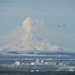
Redoubt in April 2009 with Anchorage in the foreground (along with two F-22 Raptors). Image courtesy of Calvin Hall.
It has been quite some time since I talked about Redoubt, mostly because the volcano has been in the "slow extrusion of a dome" mode that has not generated much beyond impressive steam (with some ash) plumes. The volcano continues to stay at Orange/Watch status. I did glean a few interesting facts and speculations about the future at Redoubt from Dr. Jake Lowenstern of the USGS the other day, including:
The new dome growing on the volcano has more room to expand than the 1989…
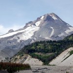
Back in the days when Eruptions was on Wordpress, I held a vote about what volcano should be the next to be profiled on this blog. The winner was Mt. Hood in Oregon, and after much waiting, the profile is here. I will actually be out of town until Monday doing some house shopping in this little town. Enjoy this look at one of the most picturesque (and hazardous - #4 in fact) volcanoes in the lower 48 states.
VOLCANO PROFILE: MT. HOOD
Mt. Hood, Oregon in August 2008 taken by Erik Klemetti.
Location: Oregon, U.S.A.
Height: 3,426 m / 11,240 ft
Geophysical location: Along the Cascade arc where…

Mt. Baker in Washington. Image taken by John Scurlock.
Eruptions reader Robert Somerville brought to my attention the Mount Baker Volcano Research Center, a "clearinghouse for research on Mt. Baker" in Washington state. The center is a non-profit organization that is affiliated with the Geology Department at Western Washington University - and from the looks of the website, they've already done a great job in compiling a lot of information about Mt. Baker, including an excellent eruptive history of the volcano. Mt. Baker is one of the most active Cascade volcanoes, with active fumarolic…

Llaima in Chile, taken on April 9, 2009. Image courtesy of the NASA Earth Observatory.
The NASA Earth Observatory (currently celebrating its 10th year) has posted a number of great images of the current eruption of Llaima in Chile, taken from Earth Observing-1 and Terra Satellites. They show both the ash plume of the eruption and the lava flows associated with it (above). The image here is a false-color image of Llaima, where the bright red/orange is the lava flow from the volcano, along with the dark brown of the ash/rocks from this and previous eruptions.
The eruption itself might continue…
Llaima erupting in April 2009.
Just a quick note about the eruption currently ongoing at Llaima in Chile. The volcano continues to explosively (and effusively) erupt, sending ash ~22,000 feet / 7,000 meters into the air. This eruption has produced 37 hours of intense eruption (in spanish) so far and the ash from the eruption is drifting into Argentina, almost 100 km to the SE of the volcano. More evacuations are being called for by ONEMI and so far 71 people have left the vicinity of the volcano due to fears of lahars and significant ash fall (In spanish, but it does provide video of the…
Today looks to be a doubleheader of volcano news:
Redoubt
Image courtesy of AVO/USGS, taken by Rick Wessels. An infrared image of the north slope of Redoubt showing the hot, new dome material and hot block & ash flows confined to the valley.
At 11:30 AM yesterday, AVO put Redoubt back to Orange/Watch alert status after the volcano seem to settle down to small steam/ash plumes. Less than 12 hours later (at ~6:30 AM Alaska time), the volcano produced another large explosive eruption, sending an ash column up ~50,000 feet / 15 km and producing what seems to be a significant lahar that…
Image courtesy of AVO/USGS by James Isaak. Photo taken 3/31/2009.
No, this isn't Battlestar Galactica, but the same can be said for the Drift River Oil Terminal: this has all happened before and will all happen again. Coast Guard officials have (finally) decided to move ~6.3 million gallons of crude oil from the Chevron-owned Drift River Oil Terminal at the base of Redoubt. The oil terminal has been a flashpoint since Redoubt began to make noise earlier this year and even up until yesterday, it was unclear what, if any, action the Coast Guard might take with the facility. It had been shut…
Image courtesy of Calvin Hall. Taken 3/28/2009 during an eruption at 10:59 AM3:28 PM.
UPDATE 4/2/2009 at 11 AM Pacific: I'm moving this up from the comments, but Eruptions reader Doug Cole pointed out (and I have no idea how I missed this) that Redoubt has a new webcam! This one is at the DFR seismic station, ~8 miles / 12 km northeast of the volcano. Great views on it today showing the extent of the ash around Redoubt and the steam/ash plume. This view will also be excellent if we get any dome collapse pyroclastic flows (see below).
After a week of explosions and ash fall, Redoubt seems to…
For those of you looking for real volcanic eruption news (no, there was no "Yellowstone eruption"), here is this week's SI/USGS Volcano Activity Report.
And speaking of April Fools Jokes, this is by far my favorite (mostly by its combination of volcanoes and baseball. How could you go wrong with two of my favorite things - hat tip to Fletcher for finding the article).
Highlights (beyond Redoubt) include:
Earthquakes, tremors and steam at El Reventador in Ecuador
12,000-15,000 foot (4-5 km) steam/ash plumes were spotted at Colima, the Mexican volcano.
A shockwave was felt 10 km away from…
Image courtesy of AVO/USGS by Game McGimsey
Following the provided script, Redoubt erupted again last night, producing a 32,000 foot / 10,000 meter ash column that prompted a new ash fall warning for the Kenai Peninsula area. Thus far, though, there have been few reports of major damage being caused by the ash fall. Alaska Air has yet to resume flights to Anchorage due to the ash, but will be reassessing as the day goes on. Since then, the seismicity has settled and we can wait for the next explosion. 2 PM Alaska time? Sounds good to me.
I want to point everyone to the great video montage…
Image courtesy of AVO/USGS. Taken by Cyrus Read
Based on the current levels of seismicity over the past 36 hours, AVO has returned Redoubt to Orange/Watch status from Red/Warning. This doesn't mean that the eruption is over, just that things have settled down a bit. Flights to and from Anchorage have resumed as well. You can read the full statement here, but the take-home messages are:
AVO expects this to be like the 1989-1990 dome-building eruptions, although no new dome magma has been seen yet (mostly thanks to poor weather).
Dome collapse will likely generate pyroclastic flows with…
Image by AVO/USGS/Game McGimsey, March 23, 2009
Redoubt has simmered down some today with no new eruptions since yesterday evening. AVO's field crew not only fixed the Hut webcam, but also spotted massive lahar deposits (see above) in the Drift River valley that traveled 35 kilometers downstream and have officials on local and national levels worried about the Drift River Oil Terminal. Funny, it sounds so familiar somehow? As usual, an ounce of planning and thought about locating an oil terminal at the foot of an active volcano would have prevented about 10 tons of problems now.
AVO will be…
Image courtesy of AVO/USGS
AVO has posted a series of images taken around Redoubt and around the Cook Inlet since the new eruptions started the night of March 22nd. You can begin to see the extent of the ash fall, what the explosions have done to the Drift Glacier and the new deposits in the Drift River valley. Most of the images show a lot of meltwater mudflows and tephra deposits on the slopes of the volcano. They've also added images from satellite and radar sources that show the initial dispersal of ash from the eruptions throughout the area north of Redoubt.
Eruptions reader Akira…
The Hut webcam at Redoubt that has a great view of the hydrothermal vents near the 1989-90 domes - and the area where the current eruption is likely to be sourced - is back online. So far, we can see what looks like lahar deposits on the lower left-hand flanks of the volcano in the stream channels (likely formed by the melting of the Drift Glacier) and ash deposits all over the snow. Also, depending on the light and clouds, you can definitely see an ash column coming from the volcano.
Also, AVO is reporting that at 7:41 PM (Alaska time), a new ash column was spotted on radar reaching 60,000…
Mt. Redoubt in March 2009, prior to erupting
At ~10:30 PM (Alaskan Time) last night, Mt. Redoubt erupted. AVO and the Anchorage VAAC issued a Red Alert for ash as high as 50,000 feet (15,000 meters) around the volcano. Information is scarce about the exact nature of the ash cloud because of the fact that the volcano erupted at night. The eruption has contained at least 5 large explosion and at least one of the seismometers at the volcano has stopped reported (RSO). An ashfall advisory has been issued by the Weather Service, with ash predicted to fall throughout the Susitna Valley (which…
The Colombian government has extended the evacuations near Nevado del Huila, taking 800 families out of the danger zone near the rumbling volcano. Huila has been making a lot of noise as of late, and Colombian officials in Ingeominas and the National System for Emergencies are worried that the volcano will erupt soon, sending avalanches and lahars down the valleys of the Paez and Simbola Rivers as happened in November of 2008 (see above or the link to the Volcanism Blog). They also note that Ingeominas is installing microphones on the volcano to detect explosions in the crater to…
The lahars and mudslides near Nevado del Huila - or, in particular, the threat of more - have prompted more evacuations. Although the known death toll from the eruption and its associated lahars is still officially only in the low double digits, at least 150 people are still missing, so that may change. You can see in the photo from Belalcazar (above) that the mud inundated the town and destroyed roads and buildings easily. This is what to expect whenever lahars are generated, along with the potential for flooding afterwards due to the dewatering of the mudflows and the blockage of drainage…
I've found a few more details about the ongoing activity at Huila in Colombia, including a video report from the BBC. It seems that the eruption at Huila is a photocopy of what happened at Nevado del Ruiz in 1985 in its style: hot ash and gasses erupted from the crater melted ice/snow near the summit to create a lahar - a deadly mix of volcanic material and water that ends up like a surging flow of liquid concrete. The lahars travelled down the Rio Paez valley (see linked map - the landslide on the map is not volcanically related).
Beyond the unfortunate victims caught in the mudflows, many…
I have been out of town for the past few days, but we do have some big (and unfortunate) news from Colombia. Nevado del Huila in southwestern Colombia erupted today and the ensuing lahar (or volcaniclastic debris flow - it is hard to tell from the reports) killed at least 4 people, and possibly as many as 10*. We know that Huila has been showing signs of activity, but now it seems like it might have had real eruption, at least to the point that a lahar was produced and possible the creation of a new summit crater. Evacuations are under way and several towns have been cut off as the…
Just a brief note, but today (November 13) is the 23rd anniversary of the disastrous lahar at Nevado del Ruiz in Colombia. Over 23,000 people died when a lahar, started by a relatively minor eruption of the volcano, swept down the river valleys the side of the edifice and destroyed Armero and Chinchina. The footage of rescue efforts after the lahar were devastating and heartbreaking (caution: linked video might not be for the faint of heart). Sadly, this disaster was mostly preventable as the citizens of these towns could have had at least an hour's warning to walk to higher ground,…