Vog
A pile of news for the new week!
The glow of new lava flows from Nyamuragira in the Congo, taken from the Virunga Park Headquarters, January 2, 2010.
Mayon
PHIVOLCS may lower the alert status at Mayon to Level 2 after almost a week of lower seismicity and no ash explosions since December 29th. Schools that were being used as evacuation centers were also returned to teachers and students for the start of classes after the Christmas holiday. However, the Albay provincial government is now considering a plan to permanently move everyone who lives within the 6-km danger zone around Mayon, even…
It's the last week of classes and it's also AGU (which I will be missing for the first time in 5 years). If you happen to be at the big meeting in SF and hear something you think we'd like to hear, feel free to drop me a line or leave a comment so we can live vicariously through you.
Pyroclastic flows at Sourfriere Hills, December 2009. Image courtesy of MVO.
Some news:
UPDATE 12:40PM 12/14/2009: Just to update the Mayon news from earlier today, PHIVOLC is reporting that lava has been spotting flowing from the main crater on Mayon. Sounds like the eruption we've been waiting for is…
Its already Friday!
News!
Print of the Temple of Jupiter at Pompeii with a steaming Vesuvius in the background.
You can now wander down the streets of ancient Pompeii from the comfort of your own home or office. Google Streetview now cover the streets of the city wiped out by the 79 A.D. eruption of Vesuvius in Italy. Now, some of the articles on the Pompeii streetview give lipservice to the current threat of Vesuvius to the modern city of Naples, my favorite being:
The authorities continually monitor Vesuvius these days, and estimate they'll be able to give adequate warning if it's ever in…
Before we get to the latest SI/USGS Weekly Volcanic Activity Report (WVAR), I wanted to draw your attention to some nifty NASA Earth Observatory images from the current activity at Soufriere Hills in Montserrat. After a few puffs last week, the volcano is now releasing a relatively constant stream of ash and steam, this after ~10 months of quiescence. The two images, one on October 12 and one on the 13th, suggest there is a lot of a variability, day to day, in the plume. See the latest WVAR for more info on Soufriere Hills.
On to the Report!
Highlights this week (not including Soufriere Hills…
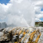
Pohutu Geyser in Rotorua, New Zealand. Image taken by Erik Klemetti in January 2009.
It has been busy busy week for me, capped off today with a talk about my field work in New Zealand (see above), so I don't have much to say. Not much new news today about the Saudi Arabian earthquake swarms, but again, I'll keep my eyes pealed (incidentally, I still haven't been able to figure out why no western news sources have even mentioned the swarm).
Anyway, here's are some volcanic tidbits to enjoy over the long weekend:
Vog, as seen from space. Volcanic fog, fashionably shortened to "vog" is a real…
Photo courtesy of Calvin Hall. Taken from March 28, 2009, 50 miles from Redoubt.
Redoubt continues to huff and puff, with an almost constant ash plume of ~15,000 feet / 5,000 meters. This after ~4 PM (Alaska Time), an explosion produced a 25,000 foot / 8,000 meter ash column that disrupted flights in and out of Anchorage again. Also, the air in the Kenai Peninsula area is beginning to feel the effects of the eruption, as AVO notes:
Satellite images from this morning show a broad layer of volcanic haze extending east of the volcano over the Kenai Peninsula, the Anchorage Bowl, and the…
Photos by Dr. Edward Kohut, all rights reserved, used by permission, 2009
Many times people think that volcanic eruptions affect the economy through the destruction inflicted upon the landscape during an eruption: lahars and pyroclastic flows destroying bridges and homes, ash ruining crops and water, lava flows overunning communities. However, in Hawai'i, a new effect of volcanism has been seen in the agriculture of the state. The volcanic fog - or "vog" as its called - has been causing major problems with farms on the Big Island of Hawai'i. Since the new activity at Halemaumau (see above)…
Although this news isn't as threatening as the title of the article implies:Â HAWAII LAVA FLOW NEARS NATIONAL PARK, it is still some news as it could be the first lava flow to cross into the park in over a lava. The flow itself is headed towards what is called the "Waikupanaha ocean entry" on the southeast side of the island. The lava flow has about one mile to go before it reaches the Pacific Ocean, but it has travelled several hundred feet (maybe 100 meters) over the last 10 days according to Park Rangers and USGS geologists monitoring the flow's progress.
Of course, compared to your…
Â
Kilauea is busy keeping geologists and tourists alike wondering what the volcano will be doing next. The current report on the volcano tells of a new fire fountain at the Thanksgiving Eve Break-out "rootless cone", about 6 miles from the ocean. The fire fountain started on Sunday night, issuing lava up to 40 feet in the air and the USGS has posted an amazing video of the fountaining on the HVO website. However, unlike the predicted behavior where magma at Kilauea starts near the summit and moves into the rifts, these lavas appear to be unrelated to the activity going on at the…
The latest eruption at Kilauea has increased the amount of vog on the big island of Hawai'i. Vog is more or less the same as the anthropogenic "smog" produced by car/industrial exhaust, but produced by volcanic gases (carbon dioxide, carbon monoxide, sulfur dioxide, hydrogen sulfide amongst others). It definitely doesn't make for good air quality, especially with the current lack of strong tradewinds in Hawai'i right now.