
Usually when I make a sentence like that it is about my wife, Amanda. But this time we're talking about Hurricane Amanda, the first hurricane of the Eastern Pacific hurricane season.
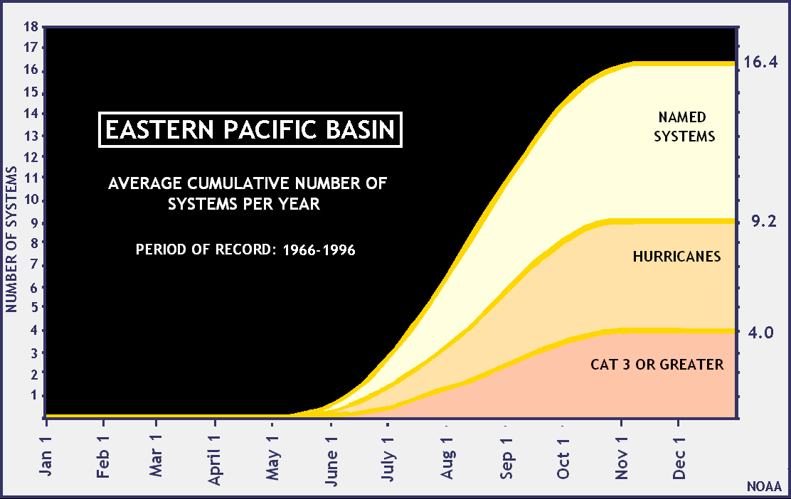
Amanda reached maximum winds of 155 mph on or about 8:00 AM Pacific Daylight Time on Sunday morning. That make Amanda the strongest Eastern Pacific May Hurricane on record. There are usually very few hurricanes in the Eastern Pacific in May, and the few that occur happen late in the months. Here's the historical distribution of Eastern Pacific hurricanes, form 1966-1996:
Amanda is the earliest on record Eastern Pacific Category 4 hurricane.
The hurricane date for the Eastern Pacific is not well organized and accessible (without working hard) as far as I can tell. Wikipedia is shamefully badly organized and out of date, and the NWS focuses much more on Atlantic hurricanes because they are far more likely to menace the US (though Eastern Pacific storms of course can end up in Hawaii, and occasionally hit the US West Coast ... and one actually slammed into Texas!).
So I can't say much more about Amanda. The extra intensity and early date is certainly related to enhanced sea surface temperatures in the region, but the relationship between that and the possible coming El Niño can not be established at this time. Putting this another way, we can ask the question, is the Eastern Pacific Hurricane Season going to be affected by El Niño, the answer is clearly: We'll see.
Amanda has weakened since, and is expected to continue to weaken as she moves north and turns into a tropical storm.
Maybe more impressive than its peak strength (did it just miss cat 5?), was how fast it strengthened, and and fast its expected to weaken. Kind of a one day wonder.
Yeah, I think it just missed five.
Little harsh on Wikipedia, considering what it is
Not harsh at all. Just pointing out that the pages I looked at for the EP have not received the attention the Atlantic has. The main graphic of the frequency of EP hurricanes by month is years old.
ISTM that in the past decade or so people have been paying much more attention to hurricanes in the northeast Pacific than they did when I was a kid--but it's hard for me to tell, because back then I lived in the same county where the National Hurricane Center was located, and we had good reasons for obsessing over Atlantic hurricanes. It may or may not be coincidence that at the same time, increasing numbers of Americans have been vacationing, and even living, along the Pacific coast of Mexico, which gets almost all of the landfalling hurricanes in that area.
The ocean waters south of Mexico and Central America are quite warm, but by the time you get up to the Baja peninsula, they are quite cold, comparable to what we see along the New England coast some 15 degrees further from the equator. This is the reason there haven't been any hurricanes to hit the California coast during my lifetime: storms in the northeast Pacific that make it that far north fall apart in waters that cold. But I recall reading something on Weather Underground to the effect that a hurricane made landfall in what is now San Diego County in 1858, and if the waters off California are warming at a similar rate to other ocean waters, storms like that one would be more likely. Flooding and landslides due to heavy rainfall would probably be the biggest risk (they are used to seeing Santa Ana winds, which can blow with hurricane force, and the topography would limit storm surges to within a few blocks of beaches and harbors).
Also El Niño changes the distribution of sea surface temperatures.