
Saturday Mid Day UPDATE:
Erika is now an ex-tropical storm. A real hurricane has an eye. Erika is a cartoon dead eye (see graphic above).
 When the Hurricane Prediction Center woke up this morning, they found Erika, ripped asunder by the rugged terrain of Hispaniola, to have "... degenerated into a trough of low pressure."
The latest update from the NWS says, "this will be the last advisory on this system by the National
Hurricane Center unless regeneration occurs."
Which gives me an idea. If Erika, this year's Atlantic "E" storm, does regenerate into a named storm, it should take the next letter, "F" but instead of Fred they should use a more appropriate name for a reanimated storm. It should be Frankenstorm.
Friday Mid Day UPDATE:
Erika is changing, and the forecast is changing. The somewhat more likely scenario is now that Erika will not form into a hurricane at all, but remain as a tropical storm, and pass along the east side of the Florida peninsula, or in the eastern Gulf of Mexico, or possibly pass over land staying mostly in Florida. This is completely different than the most likely scenario late yesterday, which had Erika reaching hurricane strength near Florida, but staying in the Atlantic but with the possibility of menacing the Atlantic coast somewhere.
Here is the cone map for that scenario:
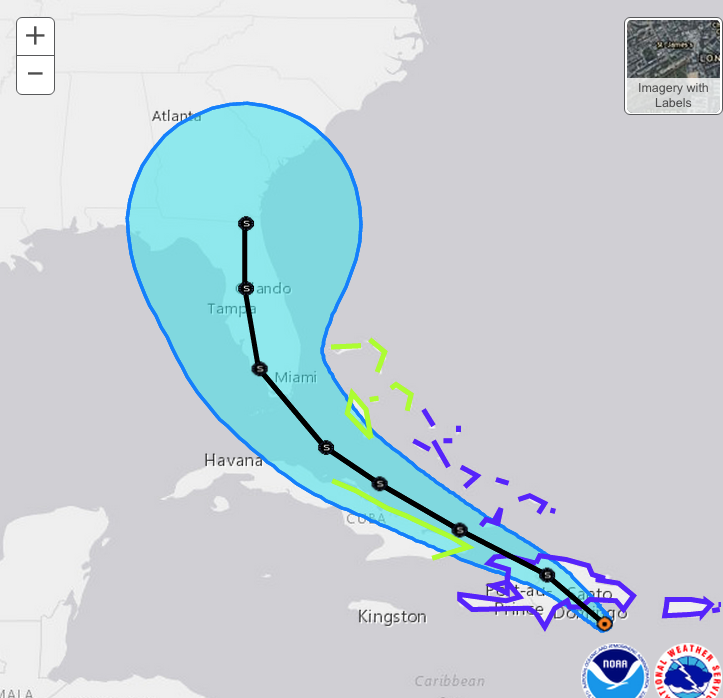
(Note also that the image at the top of the post is the most current NWS forecast.)
The alternative is that after Erika finishes its pass over Hispaniola it will strengthen and curve to the north sooner and remain in the Atlantic.
Should be an interesting 48 hours.
UPDATE:
(Latest map added to the top of the post, Thursday evening.)
First, I would like to note that there has been an odd reaction in various quarters to me posting on this storm. It is as though those who wish to deny the importance of climate and weather, and changes therein, would prefer we not speak of tropical storms. I wonder why.
The original point of discussing Erika here was two part. First, it is a tropical storm. I blog about them. Second, this particular storm had a somewhat unusual prediction of being a TS until about landfall in Florida, when it would quickly strengthen to a hurricane. That is historically interesting, but just as a coincidence, because ten years ago Katrina did the same thing. Otherwise, it is just an Atlantic tropical storm that will likely become a hurricane.
Meanwhile, five days turns into four, and we can make a better guess as to what the storm will do. Erika still has a chance as mentioned earlier of fizzling out over the next two days or so. But if the storms survives past that point there is a good chance it will develop into hurricane. But the original prediction of making landfall somewhere near, north of, Miami is changed, with the storm now more likely to curve northwards and not make a full on strike of the coast of Florida (though it may well affect the coast). After that, the storm may hug the Atlantic coast and maybe even make landfall somewhere, or curve even more and go up the Atlantic. After that, who knows?
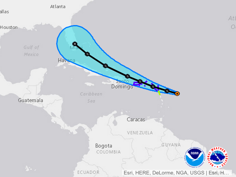
This is the the updated track:

Still turning into a hurricane near Florida, but curving away from the coast.
Also, the 120 hour estimate had the storm reaching 75mph wind strength, and the current forecast has the storm becoming stronger in 120 hours (because the forecast moves forward with time, not a change in the nature of the storm).
Meanwhile, the storm is affecting the Leeward Islands. Flooding is occuring in Dominca. Weather Underground has this. As noted by Jeff Masters, the European Model is giving Erika the best chance of being strong, and near Florida.
I've looked at a handful of models and got some opinions of various experts, and most of the forecasts seem to show Erika staying in the Atlantic, but with a distinct possibility of making landfall somewhere. Florida is not out of the woods yet, North Carolina is a target in a handful of forecasts. A small number of models put Erika in the Gulf which puts it over some very warm water (and probably requires crossing the Florida Keys).
So, at this time, here is the basic question at hand. Which is more likely? Hurricane Erika forms and hits land, or Donald Trump gets the GOP nomination? At this point I'd bet on Trump but I would not take my eyes off of Erika.
Original Post:
On this ominous anniversary of Hurricane Katrina, we have the North Atlantic Hurricane Gods playing with our heads a little.
Here's the thing. One of the effects of recent global warming is the overall increase in tropical storm activity, in all ocean basins, in recent years, and projected through the 21st century (see this for important research on this topic). Even so, due in part to effects of climate change in Africa and in the Pacific, and also (at present) El Nino, there has been notable attenuation of hurricane activity in the Atlantic Hurricane Basin. Generally, tropical storm activity has been rather impressive world wide over the last several years, and some of the tropical storms have done things that tropical storms don't generally do, and those things are often likely attributable to global warming. For instance, Yolanda/Haiyan was extra strong, likely, because of extremely warm ocean waters at depth, rather than mainly near the surface. (Katrina was probably enhanced by this effect as well.) Obviously Sandy is an example. We have seen many days over the last couple of years with a very large number of Pacific storms existing simultaneously. We've seen tropical storms maintaining hurricane strength, or in some cases forming up, farther from the warmest equatorial regions than usual. And so on.
But, as noted, the Atlantic has mostly been relatively quiet, owing to a strong vertical wind shear and excessive Saharan dust, both predicted effects of climate change, but bad for hurricane formation. This year has been anemic as was last year, in the Atlantic.
(An important message here is this: If you live or have assets along the Gulf or the Atlantic, don't become complacent!)
But now we have an interesting new storm that is doing two interesting things. The storm is Erika. The storm is heading towards the norther Lesser Antilles, and its effects may graze the northern regions of the Greater Antilles, as the storm track heads towards south Florida. The storm is predicted to remain as a tropical storm, not reaching hurricane strength, over this entire period. Then, the storm is (currently) predicted to make landfall in Florida, not far from Miami. The current track puts the storm's center north of Miami (which would be good for Miami) but it is way to early to tell exactly where the storm will go.
So that's one interesting thing: heading for Miami, which is a highly vulnerable population dense region in a red (thus denialist) state that has avoided a lot of tropical storm activity over many years.
The second interesting thing is that current models seem to have tropical storm Erika turning into Hurricane Erika just as it arrives in the Miami area. This is a Bizarro Storm if there ever was one. Instead of being a hurricane at sea and a tropical storm on land, it is, if the predictions hold, going to be a tropical storm (mainly) at sea and a hurricane (mainly) on land.
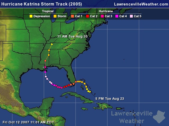
One of the things you may remember about Katrina is that Katrina hit south Florida as a tropical storm right on the border of hurricane strength, strengthened even as it made landfall, sauntered across the peninsula, entered the Gulf of Mexico where it weaved a bit, and turned north, turned into a powerful hurricane, and hit New Orleans. Like this:
Will Erika do this as well?
We don't know. Or at least I don't. There are meteorologists out there with models that they run way out in time. I remember hearing from the grapevine that Sandy was going to head north and hit somewhere around New York way before anyone was saying it publicly. Responsible meteorologist did not run around alarming people until they could be more sure. I've not even asked around about Erika.
The current path for Erika, as predicted, looks like this:
And up close (this is VERY far out so don't use this to plan your evacuations or even your Hurricane parties) looks like this:

So somewhere between four and five days, "landfall" might occur near Miami, with currently predicted sustained winds at about 75mph.
It is clear that everyone in southern Florida (all across the peninsula, not just the Atlantic coast) needs to keep an eye on this, just for the heavy rainfall if nothing else. But things are very uncertain. The NWS is only issuing statements out to near the Bahamas at this point.
There is, of course, no such thing as ghosts. And there is no Hurricane God of the Atlantic. But Erika serves to remind us of Katrina, just in case anyone forgot (unlikely). And, Erika might be a serious storm, but will be interesting no matter what.
This from Eric Holthaus at Slate:
No place in America is more exposed than Miami, but amid a record-breaking lack of hurricanes in recent years, the booming city’s residents have grown complacent. Earlier this year President Obama traveled to the Everglades to highlight the region’s increasingly desperate battle to hold back the rising sea. Simply put, the region is overdue for a Big One.
Tropical Storm Erika is not that storm, yet. And the truth is, meteorologists won’t know how exactly powerful Erika could be for another day or two, at least.
Eric goes on to lay out his odds, very rough at five days out. Death in the Caribbean: 2 in 10. Weak landfall in Florida Panhandle, 2 in 10. Hurricane landfall in South Florida, 5 in 10. Worst case scenario (we shall not explore that here at this time): 1 in 10.
So, again, the binary message that I'm trying to stick to here. 1) This is something to pay attention to. 2) Five days is way to far into the future to say much. This storm could even totally fizzle out before hit hits Florida. Or not.
And to add a tri-nary to the binary, and to restate the original point of this post, Erika serves, because of its uncanny (but coincidental) similarity to baby Katrina, to remind us of that still unresolved disaster.
This might be a minor big deal. Or a bigger big deal. Only time will tell.
It was pointed out yesterday on Jeff Masters' blog that Florida (all of Florida, not just the Miami-Fort Lauderdale-West Palm Beach corridor) has not had a landfalling hurricane since Wilma in 2005. Since then, we've had the tail end of the housing bubble, which means that many structures there have never been through a hurricane. And Florida has a history of builders subverting construction codes. If/when we discover a bunch of that kind of stuff going on in the bubble years, as happened in the pre-Andrew years, expect house insurance to be that much harder to get in Florida.
The Southeast Florida coastline has been close to built out for decades, so apart from redevelopment projects I expect the worst effects to be in some of the newer developments inland. That's what happened with Andrew: some of the worst affected neighborhoods were relatively new houses well inland, and far enough north to have seen no worse than Category 1 hurricane winds. (Code at the time called for houses to be able to withstand 125 mph winds.) Older neighborhoods closer to the ocean generally fared better, especially houses built prior to 1965 (which survived Betsy, the previous hurricane to hit the Miami area before Andrew), even against stronger winds than most of these newer neighborhoods saw.
An added complication is that Miami will have a high spring tide of 101 cm at 10:30 AM Monday. This is in the 98th percentile of high tide levels predicted for the year (range 55 cm to 110 cm, mean 76 cm, stdev 10.4 cm).
Gusts in St. Aug right now are 65 mph
I remember visiting the AmericanWX forum a couple weeks before Sandy made landfall. At 10 days out, IIRC, ECMWF was showing the 'left turn' into NY. At 8 days out that solution was being seen by many of the models. I was impressed.
I didn't think they named tropical storms?
This is the clearly a short term worry for Florida - the long term prospects for it are even worse :
http://www.abc.net.au/news/2015-08-27/sea-levels-set-to-rise-nasa-says/…
Within a century - and that estimate is likely to be erring on the conservative side given the faster than expected loss of Arctic sea ice.
Of course since Katrina the US President and surely the disaster relief plans have been improved dramatically so a repeat of anything quite like that is hopefully never going to happen again.
@Stevo: New Orleans has large areas that are actually below sea level, due to some combination of soil compaction and groundwater pumping. So they need the levees to keep the ocean and the Mississippi River out of New Orleans. (Paradoxically, the levees are also needed to keep the river in New Orleans, but that's a separate topic.) Florida is still above sea level--admittedly not by much (downtown Miami is about 7 m above sea level, which is what passes for high ground in southern Florida).
I don't know what the rules are for the South Pacific, but Atlantic and North Pacific tropical cyclones normally get names when they reach tropical storm status. Once in a while a tropical storm (or even a hurricane--the Perfect Storm of 1991 briefly had that status) will only be found in retrospective analysis, but those are the exceptions.
@ Eric Lund: without having a high resolution DEM at hand, I believe much of Miami is less than 2 m above sea level.
Greg, if there is any reason that some don't want you writing about this tropical storm, it's because they know you're going to do everything you can to link this storm to global warming/climate change/weather weirding or whatever the term du jour is. You guys keep hoping for another Katrina (the new normal, right? ) and yeast after year, it doesn't happen. The sense of disappointment among alarmists is almost palpable. But, I'll give you this, you're not going to let reality get in the way of your constant doom and gloom.
Reality gets some pretty grotesque distortions as it passes through the minds of conspiracy alarmists and their cognitive dissonance denial processors...
Someone should get an awesome PhD thesis studying this effect. Well, dozens & dozens should, actually -- there's so MANY case studies available to gather solid data sets...
Pinroot, so, if I was intent on linking this storm to a particular change in weather, would that forgive some sort of effort to silence the conversation?
When you say "you guys" you should specify what you mean. If you mean the community of legitimate climate scientists and science writers, than I suppose that makes sense but you should probably clarify.
In the original post I did indeed link conditions in the Atlantic to climate change, in two ways. First, because of a combination of anthropogenic causes and (probably) El Nino, we see attenuation of the Atlantic hurricane season over the last couple of years including this year. Indeed, the same basis modeling approaches that are used in climate change research have been applied year after year to make predictions of the likely intensity of each Atlantic hurricane season. Those predictions have been very accurate, verifying the validity of the modeling approach and the models themselves.
Second, there is a long term projection from climate modeling that despite small scale (and the Atlantic is very small compared to the rest of the world's oceans) attenuation of hurricane activity, there should be an overall increase in hurricane activity. That overall increase has been observed. We expect it in the Atlantic as well.
I suspect that at present and for a few years we'll see the Atlantic shift back and forth between the "new normal" of increased tropical storm energy and the other "new normal" of regionally attenuated activity. This, sadly, could result in periods of growing complacency punctuated by high activity years where at least the first major hurricane landfall or two are not properly handled by the generally anti-science state governments and an inured populous. This will cost lives.
However, there is a way to address that problem (other than the obvious and critical requirement that we do what we can, as fast as we can, to keep the carbon in the ground). Do you know what that is? It is to talk about the damn hurricanes.
So we can avoid talking about the hurricanes, perhaps even actively silence discussion, and thus increase the overall loss of life and damage to property as a result of social or other means of limiting free expression. Or, we can talk about the hurricanes openly and honestly and perhaps save a few lives and slightly diminish the severity of outcome that is inevitable when hurricanes hit land.
You seem to be in favor of the former. Why? Be clear in your answer. We all want to know.
I'm calling for a Cat-2 storm. Some winds that reasonable residents have prepared for, Rain that they need. Check back next week to see if I am right.
I'm calling it a "good storm". The alligators will love it.
@6 Eric Lund : Thanks for that info about tropical storm's being named didn't know that before.
A point to consider with Florida and other low lying area is that it isn't just sea's rising but also increased erosion, storm impacts made more severe by stronger surges, higher tide impacts etc ..
@8. Pinroot : "You guys keep hoping for another Katrina (the new normal, right? ) and yeast after year, it doesn’t happen."
Guess hurricane Sandy :
https://www.youtube.com/watch?v=X-G6Z2xDuM4
was just a figment of the imagination then?
Elsewhere I guess Typhoon Haiyan /Yolanda (2013) :
Source : Typhoon_Haiyan wikipage
Didn't happen on your planet either?
Then there's this rather interesting and telling fact that of the ten most intense Atlantic hurricanes five of them (Wilma, Rita, Katrina,Dean & Ivan) have occurred in the past (not even) 15 years. Co-incidence?
Source : wiki page / List_of_Atlantic_hurricane_records#Intensity
Hurricane Wilma (2005) holds many records including fastest Intensification from a Tropical Storm to a Category 5 Hurricane and maximum pressure drops in both 12 & 24 hours. Hurricane Sandy (2012) is the largest in diameter on record - and of the top five in that category four came in the last 15 years and the other Lili in 1996.
Source wikpedia : List_of_Atlantic_hurricane_records page
So .. what do you make of that? That all being just happenstance starts to look pretty unlikely don't it? (Possible just maybe but not that plausible.)
@11. Mark Schooley MD : "I’m calling it a “good storm”. The alligators will love it."
They probably will, the people on the other hand .. probably not so much even if its only a small one this time.
On second thoughts maybe the alligators won't be quite that happy after all? :
Source : http://www.ncbi.nlm.nih.gov/pubmed/19937751
It appears Erika has dissipated into a trough of low pressure. Perhaps if it goes into the gulf it will strengthen into a tropical storm again but it doesn't appear that it will turn into a hurricane.
It appears Erika has dissipated into a trough of low pressure. Perhaps if it goes into the gulf it will strengthen into a tropical storm again but it doesn’t appear that it will turn into a hurricane.
wow am so scared because we got a new tropical storm named Fred and he is really wide I am jus happy I wasn't around when Andrew was
anybody have any updates on Freds next move