Filed under "Wow, this is cool!" we have a global real time wind map! (click the image)
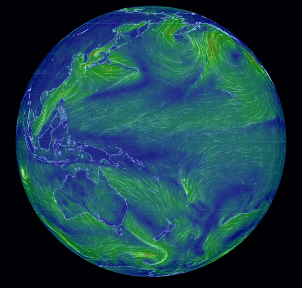
The "About" page is here. Don't miss the fact that you can zoom in.
Filed under "Wow, this is cool!" we have a global real time wind map! (click the image)
The "About" page is here. Don't miss the fact that you can zoom in.
Thanks for the link to this map.
This is really cool.
coby,
I've been playing with that map since someone linked it on Jeff Masters' blog a few days ago.
It has some very interesting features - incredible zoom, ability to see airflow at various heights, etc. Just click on 'earth' in the lower left-hand corner, and a number of viewing options pop up.
Click on 'earth' again, after you've chosen your options.
Someone did an amazing job of integrating data with graphics. Does anyone out there know who 'nullschool.net' is?
This is a forecast map, correct? Not actual as-measured wind. But still one super-cool visualization of big data. Bravo!
Cameron Baccario from Tokyo made this. It is not forecast winds but current winds minus 3 hours. There are two tropical systems to the East of Madagascar which are worth viewing at this time!
http://www.slate.com/blogs/future_tense/2013/12/18/global_wind_map_came…
BTW you can look into the future by using the "control" area of the earth button. Global winds at 250 Hpa (MB) are your jet stream winds (generally) while 500 Hpa are your 'steering' winds. (Gives indication of where your weather systems are going and if they will strengthen or decline.) 850 Hpa is land surface winds and 1000 Hpa is only appropriate for water as this is near sea level and is therefore not properly measured over most land surface.
Hah! just clicked on the "about" button at the bottom and it has all this info on it including the GitHub source code.
(although it puts the 1000Hpa as sfc which really is not reliable if your station pressure is 997.0 etc)