Atlantic Hurricane
Update Thursday AM
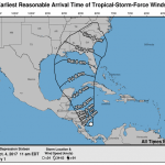
As expected, Nate emerged as a named storm over night. The storm is now interacting withland in Central America and is therefore having trouble getting organized. And, as expected given the uncertainty this causes, the forecasts are unclear on future intensity. The most recent National Hurricane Center projection has Nate Maxing out as a much weaker storm than yesterday's projection suggested. And, the center of the expected path of the storm has shifted west and is now centered roughly on New Orleans.
After leaving Central America, Nate is expected to pass just over the…
Friday, May 27, 11 AM cst
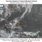
The probability of this disturbance turning into a tropical storm has been upgraded to 90%, and this transformation is expected to happen some time this evening or on Saturday.
Once that happens, the NWS will probably start issuing maps and probability information for where the storm will go and how strong it will be. For now, the NWS is indicating that "all interests along the southeast coast from Georgia through North Carolina should monitor the progress of this low."
There is not much to look at yet, but here is a moving GIF of the area. The low pressure system is…
SEE ONGOING UPDATES BELOW FOR THE LATEST INFORMATION
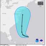
Tropical Depression Eleven is currently located way east of Florida, and is predicted to become a tropical storm by Tuesday night some time. It would be nameD Joaquin. Some time Wednesday night, the storm is predicted to turn north and head straight up along the coast. There are no significant advisories or suggestions of a threatening situation from the National Weather Service, but it is always a good idea to keep an eye on these storms.
It was predicted that there would be about 12 named storms this season. There have been 9 so far,…

There is an 80% chance that a disturbance in the Gulf of Mexico will become a tropical cyclone, a named storm, over the next couple of days. If that happens it will be called Bill.
Possible Bill is not well defined and is poorly organized. The disturbance is currently near the Yucatan, and will move northwestward over the next couple of days where it may pick up enough energy and be left sufficiently alone to crank up. The most likely coastal area to be affected are along Texas and parts of Louisiana. Even if the disturbance does not turn into a named storm, that region will likely…

Maybe yes, maybe no. Good chance, yes.
It is too early to call, but the blob I mentioned the other day has turned into a spiral and is starting to get organized. Forecasters at NOAA think there is an 80% chance this low pressure phenomenon will be a tropical storm by the 4th of July. They are also, somewhat vaguely, saying that it will move south, then northward, then northwest, which puts the storm off the coast of the US Mid-Atlantic or Southeast somewhere. Given that the storm is not moving in a consistent direction steered by well defined one directional forces, this should be very…
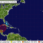
There are at present two systems in the Atlantic that have a good chance of producing tropical storms and possibly, eventually, hurricanes. One is east of the Yucatan, the other is very near the coast of West Africa.
Here's the report from the National Weather Service. I've used a rough routine to convert case so it is not screaming at you (the NWS has not yet implemented the rumored policy of not using ALL CAPS FOR EVERYTHING.
1. The broad area of low pressure in the northwestern caribbean sea is moving toward the west-northwest at 10 to 15 mph. Cloudiness and showers associated with…