earth observatory
Finally, a chance to catch up a bit ... !
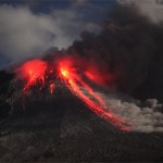
Yasur erupting in May of 2010.
Some news from the world of volcanoes:
The BBC has a series of videos one the fallout from the Eyjafjallajökull eruption - including a look at the area around the volcano and how the economy has been affected by the eruption. However, things seem pretty quiet at the summit of the Eyjafjallajökull summit where snow can begun to settle without melting - and the Icelandic Met Office appears to think that the eruption is more or less (but not officially) over. And take this press release as you will, but a recent study…

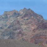
Mt. Hood in Oregon, taken August 2008. Image by Erik Klemetti. Click on the image to see a larger version.
Quick news!
I'm not going to go into too much depth right now about the recent study published in Nature Geoscience on Mt. Hood in Oregon - I plan to talk about it more in a few weeks. Why is that? Well, the lead investigator on the study, Dr. Adam Kent of Oregon State University, is a friend of mine (and occasional Eruptions commenter) so I plan to get the details from him before posting. I was also peripherally associated with some of this work - mostly in the field acting as a pack…
The northern Chilean and southern Peruvian Andes are full of volcanoes that look stunning - I mean, jaw-dropping details of volcanism litter the landscape. The reason for this is two fold: (1) there is an awful lot of volcanism in the northern Chilean/southern Peruvian Andes (as known as the Central Volcanic Zone) - and has been that way for over 10 million years and (2) it has also been very, very dry in the area (most of which is known as the Altiplano-Puna Plateau) for at least a few millions years as well - it is the home of the Atacama Desert! So, this means you get lots of volcanic…
Tourists hiking next to an active lava flow on Pacaya in Guatemala in 2006.
I'm flying back to Ohio today after a successful few weeks of fieldwork/paper writing. Apparently I have a pile of tomatoes waiting in our garden in Granville ... !
On to news:
To go with the news that lava flows from Kilauea creep ever closer to structures in Kalapana, the NASA Earth Observatory posts its first volcano image in a bit. The shot shows the steam-and-gas plume from the Halema`uma`u Crater in Kilauea's summit caldera. You can also see some video of the lava flows near Kalapana as they move along the…
This week went fast, didn't it?
The Baekdu caldera along the North Korean/Chinese border.
The NASA Earth Observatory have been giving us a steady diet of volcanic plumes over the last week, including PNG's Ulawun, Russia's Sarychev Peak (a very faint plume), both an ASTER and Terra image of the summit region at Kliuchevskoi and finally a mix of plume and clouds over PNG's Manam volcano.
I wanted to also mention a brief article I ran into on the Changbaishan/Baekdu caldera along the Chinese and North Korean border. Although short on specifics, this article mentions a number of interesting (…
The NASA Earth Observatory has been dazzling us with images from the Eyjafjallajökull eruption for months - but they have been dazzling us with volcanoes images for years! Here are two more images for those of you who love seeing volcanoes from above:
Cleveland, Alaska
As I mentioned earlier this week, Cleveland volcano likely had a small eruption over the weekend producing a small ash cloud. Cleveland is already known as an extremely picturesque volcano, both from the ground for its highly conical shape - a textbook andesitic stratocone - and from space. This new June 1 image is from almost…
News, news, news!
Ash from Eyjafjallajökull piling up on a roof at Seljavellir. Image courtesy of the IMO, by Ari Tryggvason.
The latest from Eyjafjallajökull has the volcano continuing to puff away - producing intermittent airspace closures over Europe. The Icelandic Met Office reports a ~7 km (21,000 foot) ash plume, but they note that the explosivity of the eruption seems to have waned some since a maximum on May 13. Right now, the IMO estimates the eruption rate at ~200 tonnes/second. Lets put that in a little perspective - a Ford F-150 pickup weighs about 2 tonnes, so the volcano is…
Actually, no the volcanoes aren't from space, but pictures of the volcanoes were taken from space. The NASA Earth Observatory has posted three more gems of volcanic activity taken by one of the fleet of earth imagers in orbit:
A recent image of Chaiten taken by EO-1. Image courtesy of the NASA Earth Observatory.
There is a great image of the busy Kamchatkan Peninsula, where four volcanoes are seen erupting in a single image - Kliuchevskoi, Bezymianny, Shiveluch and Karymsky. The plume from Karymsky is especially prominent as a grey streak above the white snow of the Russian winter (albeit…
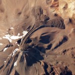
As a volcanologist, I am partial to impressive lava flows, especially in volcanoes that erupt material that you'd think wouldn't produce big flows. For example, there are quite a few volcanoes in the Chilean Andes that erupt dacite lavas, which are relatively viscous (sticky), so you might expect it to erupt explosively. However, you can get large dacitic to rhyolitic lava flows, quite commonly, and these large flows are called coulées (a "volcanic dome flow").
Lllullaillaco volcano on the Chile/Argentina border. Note the very prominent coulée with flow levees. Click on the image to see a…
Alright, I'm actually in Wisconsin right now for a wedding, but this was too cool to pass up ... the folks from the NASA Earth Observatory sent me this image (Natural-color, 10m/pixel) from the Advanced Land Imager aboard EO-1 of the Eyjafjallajokull-Fimmvörduháls eruption, both taken on March 24, 2010.
The Fimmvörduháls eruption in Iceland, taken March 24, 2010. Image courtesy of the NASA Earth Observatory. Click on the image for a larger version.
You can clearly see the flow heading down the drainage to the east, slowly snaking down the snow covered area. I think the steam plume on far…
I'm still playing catch-up after my week in the desert, so I've seen a lot of articles I've wanted to mention ... but a certain other volcano has taken up a lot of my time. However, I will attempt to make amends for that now.
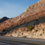
By the way, would you believe Ubehebe Crater was closed? How do they close a volcano, anyway? However, I did get a great snap of a welded tuff on the road outside of Shoshone, CA.
A strongly welded tuff near Shoshone, CA. The dark interior is remelted volcanic ash/tephra surrounded by less welded pink tuff with abundant pumice clasts. Denison student David Sisak is on…
Did I mention its a busy week?
The lava lake at Erta'Ale in 2008. Image courtesy of Stromboli Online.
Our Icelandic saga continues, with more earthquakes and more speculation/information on the parts of Eruptions readers. Keep up the discussion - I'll be fascinated to see who turns out to get closest to what actually happens, prediction-wise. The seismicity has quieted somewhat again in the last 12 hours, so we wait eagerly to see what comes next. Remember, Iceland is the land where volcanoes helped change history, so it is always fun to talk Icelandic volcanism.
The NASA Earth Observatory…
Cleaning up some news ... busy week leading up to a field trip I am helping co-lead to Death Valley next week.
Ubehebe Crater in Death Valley, California
First off, I want to say how amazed I am at the great discussion that went on all weekend about the signs of potential activity in Iceland. It now appears that the earthquakes at Eyjafjallajökull may be waning, however the levels of seismicity have definitely bounced up and down over the last few days. However, the level and depth of the conversation is a testament to all volcanophiles out there. Nice job, folks.
For those of you into…
Catching up with some news:
Anatahan erupting in the northern Mariana Islands in 2003.
I ran across this article right before I got sick, but its been popping up around the interwebs (and is pretty interesting). It details a study in Molecular Ecology that suggests that populations of caribou in Canada's Yukon Territory were strongly effected by the White River Tephra. The White River Tephra is supposedly the largest Holocene plinian tephra (from a ash cloud fallout), with two components dating from ~1900 years ago and ~1250 years ago. The vent for the WRT is likely from a vent beneath the…
Not a lot of big news, but a lot of little news:
Soufriere Hills at night during the late January 2010 dome growth episode. Note the hot rock falls from the collapsing dome. Image courtesy of Photovolcanica.
This might not be new, but Dr. Boris Behncke brought the new webcam at the rim of Chaiten in Chile to my attention. You get a birds-eye view of the growing dome from the edge of the caldera - pretty nifty view for a once-in-a-hundred-years sort of event.
The NASA Earth Observatory has posted a close-up of the Soufriere Hills imagethat I posted yesterday, showing the February 11 plume.…
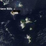
A couple bits of news:
The ash plume from the February 11, 2010 eruption of Soufriere Hills taken by theAqua MODIS camera. Image courtesy of the NASA Earth Observatory.
Flights have been disrupted in the West Indies since last week with the large dome-collapse eruptions of Soufriere Hills on Montserrat. The 10 km / ~35,000 foot ash plume is apparently lingering in the air at commercial flight levels, meaning delays, cancellations or long detours for many flights in the area. Flights in and out of Dominica, Guadelope, Montserrat, Anguilla, St. Kitts and Nevis have all been effected by the…
Two impressive eruptions going on right now:
Soufriere Hills erupting on February 11, 2010. Image courtesy of the Montserrat Volcano Observatory.
Soufriere Hills just keeps on raising the bar during its new eruptive period. The volcano on Montserrat in the West Indies produced a 15 km / ~45 000 foot ash plume as the summit dome partially collapsed again. It was one of the biggest volcanic events at Soufriere Hills in the last 15 years, with 10-15% of the dome collapsing. One of the regional airlines in the West Indies have had to cancel flights due to the ash that has mainly been heading to…
News!
Pakistan is home to the world's tallest mud volcano in the region of Balochistan - and its somewhat near the reports of an "eruption" earlier this week.
Guess what? Since Wednesday evening, seismicity at Yellowstone has dropped precipitously. The last batch of earthquakes on February 3rd were also back to deeper levels - 8-9 km depth - compared to the potential shallowing earlier in the week. I'm sure the caldera will keep us on our toes, but as of now, it seems to have settled down a bit.
Over in Pakistan, there is mounting evidence that the recent "volcanic" eruption reported as, in…
Let me now sing the praises of NASA's Earth Observatory, a phenomenal web-based public education resource that is celebrating its 10th birthday today. Every day for the past decade, NASA has been uploading spectacular remote sensing images and astronaut photographs and accompanying them with clearly written, jargon-free but scientifically accurate explanations of the pictured phenomena. The Earth Observatory is one of my favorite web destinations, and I get their weekly email newsletter, and follow them on twitter. (Follow me!)
On numerous occasions, I've used Earth Observatory images to…
Your canopy is disappearing, you're likely to freeze.
NASA's Earth Observatory reports that over 1,110 acres of forest were illegally logged, during the past four years, in the Monarch Butterfly Biosphere Reserve in central Mexico.
Monarch butterflies travel here from all over the United States and Canada. Images from the Ikonos satellite tell us though, that future migrating butterflies are likely have problems in this reserve. The top image is from 2004, the bottom image shows what things are like now.
NASA's Earth Observatory
Without the trees to protect them, the butterflies could…