explosive eruption
Redoubt from Ninilchik, AK. Image courtesy of Calvin Hall.
It has been a few days since we've talked about Redoubt. Well, it might be because the volcano has settled down for the past week, to the point that AVO put the volcano back to Orange/Watch status last week and hasn't had to go back to Red/Warning since. This is not to say the Redoubt is quiet, on the contrary, there is still elevated seismicity, an almost-constant steam/ash plume up to 15,000 feet / 5,000 meters and most importantly, the new dome (below) is still growing near the summit. The system has been actively degassing carbon…
Fernandina, Ecuador
Fernandina erupting in 2009.
UPDATE 4/13/09 at 12PM: The NASA Earth Observatory has posted a nice MODIS image showing the plume from the Fernandina eruption drifting out over the Pacific.
We have a few more details on the ongoing eruption at Fernandina in the Galapagos Islands. Officials from the Parque Nacional Galápagos (PNG) flew over the island (in spanish) and saw the eruption is coming from a several-kilometer-long fissure vent that flows towards the sea, dividing into multiple flows and then coalescing when it reaches the sea. There is also a lot of vapor being…
Chaiten erupting on January 19, 2009. Image courtesy of the NASA Earth Observatory.
It is hard to believe that we are less than one month away from one-year anniversary of the beginning of the eruption at Chaiten (and with it, the one-year anniversary of this blog!) The volcano in southern Chile is still erupting away, creating at least 2 dome complexes within the older caldera. These domes have been experiencing periodic collapses, creating block & ash flows, some of which have made it out of the caldera and down close to the ghost town of Chaiten. Along with the block & ash flows,…
Fernandina volcano in the Galapagos.
Fernandina in the Galapagos has entered a new eruptive phase according to the Geophysical Institute (GI) at the National University of Ecuador (in spanish). Satellite images show a new crater and ash column from the volcano and the GI will look for evidence of new lava flows beyond the "hot points" spotted on the satellite images.
UPDATE 4/11/09 9PM: I thought I'd add a link to the story in English now that I found one. There are also some pictures of the lava flows from La Cumbre (There is some confusion about name - Fernandina and La Cumbre are the…

Llaima in Chile, taken on April 9, 2009. Image courtesy of the NASA Earth Observatory.
The NASA Earth Observatory (currently celebrating its 10th year) has posted a number of great images of the current eruption of Llaima in Chile, taken from Earth Observing-1 and Terra Satellites. They show both the ash plume of the eruption and the lava flows associated with it (above). The image here is a false-color image of Llaima, where the bright red/orange is the lava flow from the volcano, along with the dark brown of the ash/rocks from this and previous eruptions.
The eruption itself might continue…
Tambora, Indonesia
There are big eruptions, then there are big eruptions. On April 10, 1815, Tambora, a volcano in Indonesia, produced one of the largest eruptions in human history. This eruption produced what became known as the "year without a summer" after the volcanic aerosols from the eruption produced some of the coldest summers in many parts of the world. The Tambora eruption in 1815 was a VEI 7, on a scale that goes to, well, 7*, putting it in a class of some of the largest and most violent eruptions imaginable - and I, for one, can hardly imagine what might happen if an eruption of…
Llaima in Chile erupting in 2009.
A quick note to pass along about the ongoing eruption at Llaima in Chile. The eruption did seem to be waning earlier in the week, but the news now is that debris from the eruption is partially blocking the vent. The cone of pyroclastic material (tephra) that has been ejected during the eruption is now overlapping the main crater, potentially blocking part of the vent ... and most people know what happens if you plug up a volcano that is actively erupting - blammo!
The SERNAGEOMIN is not certain that this cone of material (in spanish) will cause a more…
Canlaon volcano, Philippines
Geothermal energy is one of those sources of energy that might be able to solve a lot of the planet's energy problems - heck, the Earth has a lot of heat it is trying to get rid of, so taking that heat and turning into energy seems like an easy (and clean?) way to stop using fossil fuels and the like. Of course, like any supposed panacea, it has its problems.
However, one aspect that gets people are riled is whether drilling into areas of active magmatism might actually cause volcanism. Just in the last few weeks, a controversy was sparked in the Philippines…
Image courtesy of KVERT, taken by L. Kotenko on Marhc 18, 2009.
To me, one volcanic arc about which I wish I knew more is the Kuril-Kamchatka arc. I'm well aware of how active it is, with giants composite volcanoes like Bezymianny, Koryak, Klyuchevskoi and many, many others. This arc of volcanoes, although in a sparsely populated part of the world, is important to monitor due to its proximity of air travel lanes to Asia. So, any time I find out a volcano in this area - usually one that I was previously unfamiliar - erupted, I am excited.
Today's example: Ebeko. Never heard of it. Yet, it is…
Llaima erupting at night in April 2009.
Brief update for those of you following the somewhat spectacular eruption (above and below) going on at Llaima in Chile. The latest reports indicate the eruption is waning (in spanish) with less ash and explosions (in spanish) being produced. However, ONEMI, the Chilean Emergency Office, continues to keep the area on alert. So far, at least 81 people have been evacuated (in spanish) during the eruptions that gained strength over the weekend and flights between Buenos Aires and Neuquén were suspended due to the ash.
It is interesting to note the…
Image courtesy of AVO/USGS taken by Kristi Wallace showing the eruption plume on March 31, 2009.
Today's update will be relatively brief: AVO has returned Redoubt to Orange/Watch status after this weekend's eruptions. The new dome continues to grow and this is accompanied by the usual volcanic seismicity associated with dome construction. We should expect to see the status fluctuate from Orange to Red as the eruption waxes and wanes - and likely get little to no warning of the next big explosive event.
The eruptions of Redoubt has forced Chevron to halt activity for all its Cook Inlet oil…
Image courtesy of AVO/USGS by Cindy Koplin showing the ash fall in Homer, AK on 4/4/09
Not much new to report about the eruption at Redoubt beyond the fact that it continues. AVO has kept the warning level at Red/Warning after briefly dropping it to Orange/Watch on Friday night. The 15,000 foot / 5 km-tall plume on Sunday was mostly water and volcanic gases. Eagle-eyed observers also noticed a plume on the lower flanks on the north side of the volcano that is believed to be steam generated by block & ash flows interacting with snow or water. These flow block & ash flows are coming…
Llaima erupting in April 2009.
Just a quick note about the eruption currently ongoing at Llaima in Chile. The volcano continues to explosively (and effusively) erupt, sending ash ~22,000 feet / 7,000 meters into the air. This eruption has produced 37 hours of intense eruption (in spanish) so far and the ash from the eruption is drifting into Argentina, almost 100 km to the SE of the volcano. More evacuations are being called for by ONEMI and so far 71 people have left the vicinity of the volcano due to fears of lahars and significant ash fall (In spanish, but it does provide video of the…
Today looks to be a doubleheader of volcano news:
Redoubt
Image courtesy of AVO/USGS, taken by Rick Wessels. An infrared image of the north slope of Redoubt showing the hot, new dome material and hot block & ash flows confined to the valley.
At 11:30 AM yesterday, AVO put Redoubt back to Orange/Watch alert status after the volcano seem to settle down to small steam/ash plumes. Less than 12 hours later (at ~6:30 AM Alaska time), the volcano produced another large explosive eruption, sending an ash column up ~50,000 feet / 15 km and producing what seems to be a significant lahar that…
Hunga Tonga Hunga Ha'apai, taken in late March 2009
Redoubt did the tried-and-true American trick of shoving news of volcanoes in other parts of the world off the news pages, but shockingly, these international volcanoes continued to erupt. Remember that volcano in Tonga? Hunga Tonga Hunga Ha'aapi? Still erupting, weeks after the volcano was first spotted. The volcano is still disrupting air traffic in and out of Tonga, which is now even affecting the economy of the islands. Now, the problem is that tourists are creeping ever closer to the emerging volcanic island. The thing about visiting…
Image courtesy of USGS/CVO, taken March 8, 2005 from the Cascades Volcano Observatory, Vancouver, WA
For those of you looking for something to relax with and read this weekend, you could wander over to the USGS website and download yourself a copy (for free and legally) of "A Volcano Rekindled: the Renewed Eruption of Mount St. Helens, 2004-2006" (USGS Professional Paper 1750). The report comes in at a mere 872 pages (that's 697 MB download for the whole report), but you can download the pieces that interest you most as well instead of the whole shebang.
Now, I haven't read the whole thing,…
Image courtesy of AVO/USGS by James Isaak. Photo taken 3/31/2009.
No, this isn't Battlestar Galactica, but the same can be said for the Drift River Oil Terminal: this has all happened before and will all happen again. Coast Guard officials have (finally) decided to move ~6.3 million gallons of crude oil from the Chevron-owned Drift River Oil Terminal at the base of Redoubt. The oil terminal has been a flashpoint since Redoubt began to make noise earlier this year and even up until yesterday, it was unclear what, if any, action the Coast Guard might take with the facility. It had been shut…
Image courtesy of Calvin Hall. Taken 3/28/2009 during an eruption at 10:59 AM3:28 PM.
UPDATE 4/2/2009 at 11 AM Pacific: I'm moving this up from the comments, but Eruptions reader Doug Cole pointed out (and I have no idea how I missed this) that Redoubt has a new webcam! This one is at the DFR seismic station, ~8 miles / 12 km northeast of the volcano. Great views on it today showing the extent of the ash around Redoubt and the steam/ash plume. This view will also be excellent if we get any dome collapse pyroclastic flows (see below).
After a week of explosions and ash fall, Redoubt seems to…
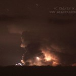
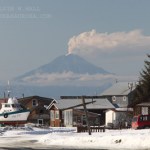
Photo courtesy of Calvin Hall. Taken from March 28, 2009, 50 miles from Redoubt.
Redoubt continues to huff and puff, with an almost constant ash plume of ~15,000 feet / 5,000 meters. This after ~4 PM (Alaska Time), an explosion produced a 25,000 foot / 8,000 meter ash column that disrupted flights in and out of Anchorage again. Also, the air in the Kenai Peninsula area is beginning to feel the effects of the eruption, as AVO notes:
Satellite images from this morning show a broad layer of volcanic haze extending east of the volcano over the Kenai Peninsula, the Anchorage Bowl, and the…
Yellowstone Lake eruption, April 1, 2009
Well, after all the seismicity and uplift at Yellowstone caldera over the last few years, something finally happened. Early this morning, without much warning, an eruption occurred in Yellowstone Lake (see above) and sent steam and ash up 50,000 feet above the park. Luckily, no one was injured or killed in the event as we're well ahead tourist season, but it is unknown how this might affect access to the park for this summer.
Now, whether this eruption is really just the caldera "letting off steam" so to speak, possibly in the form of a phreatic…