explosive eruption
Image courtesy of AVO/USGS by Tricia Joy Sadler. Taken 3/28/2009 at 3:29 PM
Redoubt did not stray from its pattern of explosive eruptions producing >20,000 foot / 10,000 meter ash columns over the weekend. However, what did change was the wind, and because of that, Anchorage began to feel the effects of the volcano. Ash prompted the closure of Ted Stevens International Airport in Anchorage for 22 hours on Saturday and Sunday. The airports near Redoubt are still experiencing delays and closure due to ash - remember, remobilized ash can be a problem as well, but many have reopened after ash…
Image courtesy of AVO/USGS by Ron Beck. Shows an ash plume from Redoubt (tan) on March 26 from a Landsat 5 satellite.
I'll be "off the grid" for the weekend at a wedding, so I thought I'd leave this open for any Redoubt news Eruptions readers hear over the weekend. Feel free to leave comments about the developments up in Alaska.
Currently, AVO reports that seismicity is lower since the eruptions this morning. They indicate that eruptions will likely occur without warning from here on in.
There are also some new articles on how the eruption is affecting air travel, including cancellations of…
Image courtesy of AVO/USGS by Game McGimsey
Following the provided script, Redoubt erupted again last night, producing a 32,000 foot / 10,000 meter ash column that prompted a new ash fall warning for the Kenai Peninsula area. Thus far, though, there have been few reports of major damage being caused by the ash fall. Alaska Air has yet to resume flights to Anchorage due to the ash, but will be reassessing as the day goes on. Since then, the seismicity has settled and we can wait for the next explosion. 2 PM Alaska time? Sounds good to me.
I want to point everyone to the great video montage…
Image courtesy of AVO/USGS, taken 3/23/09
I don't have many details, but the largest eruption so far in this eruptive stage at Redoubt occurred at 9:24 AM (Alaska Time), producing a 65,000 foot / 20,000 meter ash column! Yes, you read that right, a 20-km ash column! This is by far the largest ash column so far and AVO has returned Redoubt to Red/Warning status after this and a small explosion that occurred 30 minutes before the big one. Depending on the winds at various elevations, this sort of large ash column could threaten to coat Anchorage with ash - check the latest NOAA warnings here…
Image courtesy of AVO/USGS. Taken by Cyrus Read
Based on the current levels of seismicity over the past 36 hours, AVO has returned Redoubt to Orange/Watch status from Red/Warning. This doesn't mean that the eruption is over, just that things have settled down a bit. Flights to and from Anchorage have resumed as well. You can read the full statement here, but the take-home messages are:
AVO expects this to be like the 1989-1990 dome-building eruptions, although no new dome magma has been seen yet (mostly thanks to poor weather).
Dome collapse will likely generate pyroclastic flows with…
Its been a busy week for volcanoes between the headline capturing Tongan and Alaska eruptions. Catch up on what you might have missed with the latest SI/USGS Weekly Volcano Report (for 3/18-3/24). Highlights (beyond Hunga Tonga Hunga Ha'apai and Redoubt) include:
Galeras, Colombia has settled down a bit
More block-and-ash flows from the two dome complexes growing at Chaiten, Chile
Strombolian eruptions at Mt. Etna, Italy
Plumes of steam and minor ash were reported from Popocatépetl, Mexico
A small lahar was seen at Tungurahua, Ecuador
Ash plumes and incandescent tephra explosions were…
Redoubt seems to be setting its pattern for this part of the new eruptive period. There was another small explosion this morning that produced at 15,000 foot / 5,000 meter ash column that moved to the NNW. The seismicity has settled down since the early morning eruption today (3/25) as well.
These types of explosions producing plinian and subplinian eruption clouds that will likely lead to dome building - the same pattern seen at Mt. Saint Helens in 2004-2008 and the previous Redoubt eruptions in 1989-1990. These explosions, producing ash columns that reach tens of thousands feet, will likely…
Image by AVO/USGS/Game McGimsey, March 23, 2009
Redoubt has simmered down some today with no new eruptions since yesterday evening. AVO's field crew not only fixed the Hut webcam, but also spotted massive lahar deposits (see above) in the Drift River valley that traveled 35 kilometers downstream and have officials on local and national levels worried about the Drift River Oil Terminal. Funny, it sounds so familiar somehow? As usual, an ounce of planning and thought about locating an oil terminal at the foot of an active volcano would have prevented about 10 tons of problems now.
AVO will be…
Image courtesy of AVO/USGS
AVO has posted a series of images taken around Redoubt and around the Cook Inlet since the new eruptions started the night of March 22nd. You can begin to see the extent of the ash fall, what the explosions have done to the Drift Glacier and the new deposits in the Drift River valley. Most of the images show a lot of meltwater mudflows and tephra deposits on the slopes of the volcano. They've also added images from satellite and radar sources that show the initial dispersal of ash from the eruptions throughout the area north of Redoubt.
Eruptions reader Akira…
The Hut webcam at Redoubt that has a great view of the hydrothermal vents near the 1989-90 domes - and the area where the current eruption is likely to be sourced - is back online. So far, we can see what looks like lahar deposits on the lower left-hand flanks of the volcano in the stream channels (likely formed by the melting of the Drift Glacier) and ash deposits all over the snow. Also, depending on the light and clouds, you can definitely see an ash column coming from the volcano.
Also, AVO is reporting that at 7:41 PM (Alaska time), a new ash column was spotted on radar reaching 60,000…
The Anchorage Daily News has a report that 16 Alaskan representatives got stuck in Anchorage after the eruption started. They were headed to Juneau to vote on Alaska accepting stimulus money ("volcano monitoring" anyone?), but they were on one of the many flights canceled by Alaska Airlines today due to the ash. ADN also have reports of an "ash out" in the coastal town of Skwentna.
AVO is currently reporting that ash doesn't appear on the current radar maps in the Cook Inlet and there are no reports of new ash fall. This suggests that the ash is either staying below 13,000 feet / 4,000…
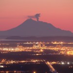
Redoubt on 3/15/2009, from Eagle River overlooking Anchorage. Photo courtesy of Calvin Hall
I'm breaking this out of the comments of the "Redoubt Erupts!" post just to keep things up-to-date.
As of now, we know:
At least 5 explosions have occurred as part of the eruption
Ash has drifted to the NNE and W - both as seen on radar and as reports of ash falling in Skwentna and the Chuitna area - and so far missing populated areas (see above)
The ash cloud is believe to have reached as high as 50,000 feet/15,000 meters - prompting an aviation warning/restrictions and cancellation of flights out…
Mt. Redoubt in March 2009, prior to erupting
At ~10:30 PM (Alaskan Time) last night, Mt. Redoubt erupted. AVO and the Anchorage VAAC issued a Red Alert for ash as high as 50,000 feet (15,000 meters) around the volcano. Information is scarce about the exact nature of the ash cloud because of the fact that the volcano erupted at night. The eruption has contained at least 5 large explosion and at least one of the seismometers at the volcano has stopped reported (RSO). An ashfall advisory has been issued by the Weather Service, with ash predicted to fall throughout the Susitna Valley (which…
Now that people have been able to get a better look at the are about Hunga Tonga Hunga Ha'apai, we've been able to get a better idea of what sort of eruption occurred. The explosions and ash/tephra from the eruption have all but wiped out life on Hunga Ha'aapai, as the island contains one of the vents, while the other is only 100 meter off shore of the island - although the tephra erupted so far have joined the new vent and the island. You can clearly see ash mixing with the water around the island and the island itself has been blackened by the coating of ash. This is a classic volcanic…
Mixing volcanoes and oceans seem to always produce exciting results. Whether it is something as simple as the ocean entry of a lava to something as impressive as a new island emerging, formed by volcanic eruption. Back in the 1960s, a previous unknown undersea volcano off the coast of Iceland erupted to form the island of Surtsey. The signs of the impending eruption were captured from start to finish, with Icelandic fisherman noticing "boiling seas", then steam explosions, then ash eruptions and finally volcanic tephra that formed the island itself. This was followed by lava flows and…
The eruption of Hunga Tonga Hunga Ha'apai volcano in Tonga looks to be a big one. Keleti Mafi, head of the Tongan geological service, calls this "a very significant eruption, on quite a large scale", which is no surprise considering some of the spectacular picture we saw of the eruption yesterday. In fact, the eruption is big enough that it has disrupted air traffic over Tonga, as Air New Zealand has issued a warning about the ash column - an ash column that has reached over 15,000 meters/50,000 feet! Luckily for the residents of Tongatapu, a mere 10 kilometers 50 km to the southwest SSE…
Image from keizo/weblog
Hunga Tonga-Hunga Ha'apai (how's that for a name?), a shallow seamount in Tonga, appears to have erupted. An air passenger snapped some pictures of an eruption occurring in the ocean between the Tongatapu and Vava'u and pilots in the area report that (unsurprisingly), the feature is new.
Hunga Tonga-Hunga Ha'apai - at least the part above water (look in the bottom of the image, the islands are marked in green) - is made of two small islands that cap the main seamount and ring the volcano's caldera. The last known eruption from the volcano was in 1988 - over twenty…
I am back from the ion microprobe lab at Stanford after a few days of data collection, so I'll be trying to get back on posting schedule here at Eruptions.
UPDATE 3/10/2009 12:45PM: Here is a little (and I mean a little) more information, mostly adding that the local residents have been given a "warning" about the activity.
However, I did notice this morning at Sakurajima in Japan erupted after rumbling over the weekend. There aren't many details about the eruption beyond the fact that volcanic chunks were thrown a few kilometers from the vent, but the BBC does have some nice video of the…
Galeras, in Colombia, appears to have entered a new cycle of activity as it has erupted for the second time in a week. A large explosion occurred this morning that was accompanied by falling ash and rocks (ballistic bombs) from the event. It is unclear how far the volcanic products travelled from the vent, but Colombian officials did raise the alert level back to red and ordered new evacuations.
Jonathan Castro has reminded me that I need a refresher on the proper terminology for ash columns related to volcanic eruptions. It is very easy to start mincing words and using them inappropriately - and that is the sort of sloppy reporting and discussion I am trying to avoid.
So, to refresh my (and our) memory on ash clouds and how to classify them, we can go back to one of the indispensable textbooks on volcanology, Cas and Wright's Volcanic Successions. The classification scheme they provide is summarized in the figure above. It shows the heights of various eruption columns…