hurricane

Harvey the Invisible Rabbit: Did not exist.
This is a picture of some men.
Since they are men, they have some abilities. They can, for example, knock each other over, and they can play with balls. This is what men do, and this is what these men can do.
This is a picture of some professional NFL foodball players.
They are also men. They can also knock each other over, and they can also play with balls. But the NFL football players are much better at knocking each other over, and you wouldn't believe how great they are at playing with balls.
They are NFL enhanced. They are trained,…
LATEST UPDATE IS HERE. CLICK HERE FOR LATEST UPDATE.
Update: Wed Mid Day
Matthew weakened, strengthened, strengthening
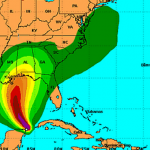
Matthew has interacted with land masses in Hispaniola and Cuba to the extent that the storm weakened quite a bit, losing its temporary Category 5 status.
But, now Matthew is already showing signs of strengthening, and is likely to grow back to Category 3 or 4 status as it moves over the Bahamas. How bad a hurricane is when it makes contact with land depends in large part on the angle of the attack, and Matthew will likely be affecting several spots in the Bahamas at a…
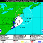
Update (Sunday PM):
Hermine is still a big storm and will affect eastern regions to some degree, but the storm never reformed as a hurricane, and is not not expected to do so. Also, the storm has jinked out to the east more than expected and will likely move farther east. So, there will be some coastal effects, but not much out of the ordinary.
POST-TROPICAL CYCLONE HERMINE FORECAST/ADVISORY NUMBER 30
NWS NATIONAL HURRICANE CENTER MIAMI FL AL092016
2100 UTC SUN SEP 04 2016
CHANGES IN WATCHES AND WARNINGS WITH THIS ADVISORY...
A TROPICAL STORM WARNING HAS BEEN ISSUED FROM WATCH HILL…
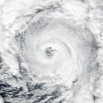
This is a huge hurricane/typhoon heading quickly, and imminently, towards taiwan.
The storm itself is roughly as wide as the island nation is long, so very little will be left unaffected.
The storm is at the very high end of the range of storms in size, strength, etc. It is currently equivalent to a Category 5 hurricane. It may weaken a bit before landfall over the next few hours, but it may remain a Category 5.
Winds, huge waves and coastal flooding from storm surges will be a big problem with this storm, but the largest problem may be the incredibly high rainfall, with about one meter of…
This year's Atlantic Hurricane season will be stronger, forecasts suggest, than that of the previous two years, and stronger than the average year.
The Atlantic Hurricane Seasons starts on June 1st. But, there was a hurricane that happened already, either late in last year's season or very early in this year's season, called Alex. That hurricane had to go somewhere, and I suppose the keepers of the records had already put their spreadsheet to bed when Alex came along on January 7th, so that storm gets counted as part of the season that will nominally start at the beginning of next month.…
Saturday Mid Day UPDATE:
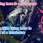
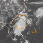
Erika is now an ex-tropical storm. A real hurricane has an eye. Erika is a cartoon dead eye (see graphic above).
When the Hurricane Prediction Center woke up this morning, they found Erika, ripped asunder by the rugged terrain of Hispaniola, to have "... degenerated into a trough of low pressure."
The latest update from the NWS says, "this will be the last advisory on this system by the National
Hurricane Center unless regeneration occurs."
Which gives me an idea. If Erika, this year's Atlantic "E" storm, does regenerate into a named storm, it should take the…
First the bad news. Taiwan is going to get slammed with Typhoon Soudelor over the next day (landfall at about 8:00 AM local time). Soudelor was one of the strongest typhoons earlier during its development but weakened to a Category 1. However, very warm seas, lack of wind shear, and other factors may make Doudelor return to category 3 or even 4 strength before making landfall. Also, it is large.
The storm is likely to hit Taiwan in about the middle, which along the east coast is not heavily populated. But it will bring heavy rains, likely causing landslides and floods, to the mountainous…
But first a word bout Chan-Hom. That typhoon messed with China but not as badly as originally feared, because the storm turned to the east a bit. Now, Chan-Hom is heading for North Korea where it will come ashore as a wet tropical storm. I would not be surprised if more bad stuff happened there than with Chan-Hom's glancing blow over the last 24 hours or so.
Now I'd like to direct your attention the Atlantic Ocean for a moment. Due to vertical wind shear and aridification-induced North African dust, we have been expecting that one effect of climate change would be that most (but not all)…
See below for update.
You may not have even noticed it, but hurricane season has officially started in the Eastern Pacific. That is because the official date of the start of season is May 15th, though the actual hurricanes rarely get the memo and start whenever they want, but usually after that date. Last year's Eastern Pacific season was much ore active than usual. The average numbers for named storms, hurricanes, and major (above Cat III) hurricanes for this basin are 15.4, 7.6, and 3.2. Last year's season was predicted to be pretty much average, but it turned out to be exceptional, with…

The outer reaches of Typhoon Hagupit are already affecting the target region in the Philippines. Hundreds of thousands of people have fled the areas most under the gun, but the potential for serious problems covers a very large area. The storm has gone through quite a few changes over the last couple of days, but is probably strengthening somewhat right now. No matter what happens, it is going to hit the Philippines as a very serious storm.
Jeff Masters has an update here.
This is the same area that was hit with Typhoon Haiyan last year. Haiyan was a bigger storm. But, Haiyan was also…
There has not been much hurricane activity in the Atlantic for a while now, so unsurprisingly the reporting is starting to slip again. This post goes out to all you reporters at CNN and Reuters and Yahoo and everywhere else. Imma give you an example of what you are doing wrong, then I'll send you to a place to learn up on it.
A recent report noted that "hurricane force winds are now bearing down on Bermuda, and the storm is expected to arrive within hours" meaning the eye would arrive within hours (paraphrased). This is not what is happening. When there is a hurricane arriving at your…
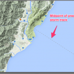
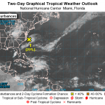
There is a stormy thing in the Atlantic that may become a Tropical Storm. It is really just a blob right now, but there is a roughly even chance that over the next two to five days it will form a tropical storm.
No matter what, this blob will menace the US east coast, though it is way too early to say if this will be a big deal or not. It is not entirely clear which direction it will be moving in over the medium term. We will be keeping and eye on it.
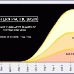
Usually when I make a sentence like that it is about my wife, Amanda. But this time we're talking about Hurricane Amanda, the first hurricane of the Eastern Pacific hurricane season.
Amanda reached maximum winds of 155 mph on or about 8:00 AM Pacific Daylight Time on Sunday morning. That make Amanda the strongest Eastern Pacific May Hurricane on record. There are usually very few hurricanes in the Eastern Pacific in May, and the few that occur happen late in the months. Here's the historical distribution of Eastern Pacific hurricanes, form 1966-1996:
Amanda is the earliest on record…
Added:
The depression has spun up to form a tropical storm. It will probaqbly remain a storm as it works its way up the Atlantic Ocean avoiding land (though it seems to be aimed ultimately at Greenland). The storm is named Melissa.
Details here.
________________
We have had a record breakingly anemic hurricane season in the North Atlantic this year. How anemic? If this year's hurricane season was a rug, you'd have a floor. If this year's hurricane season was a car you'd have a bicycle. If this year's hurricane season was a stack of pancakes, you'd have one pancake. That's now anemic.…
The anemic (perhaps due to climate change, perhaps not) Atlantic Hurricane Season has finally produced a storm that might turn into a hurricane and will hit the Gulf Coast.
Tropical Storm Karen is just north of the Yucatan and is strengthening and heading due north towards Louisana, Mississippi, Alabama or the Florida Panhandle with the current (and very much subject to revision!) bulls eye somewhere around or just east of Mobile.
The current projections indicate that the storm will turn into a hurricane while over the gulf, then weaken to a tropical storm before striking land. But it…
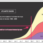
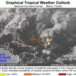
So, how has the Atlantic hurricane season shaping up so far?
According to data accumulated by the National Weather Service, as shown (with added items) here ...
... we should have had about four or five named storms at this point in the season. Since numbers for this time of year are small, variation is large, so this is not too meaningful but it can give us an idea.
So far, we have had these storms in the Atlantic:
Tropical Storm ANDREA
Tropical Storm BARRY
Tropical Storm CHANTAL
Tropical Storm DORIAN
Tropical Storm ERIN
The next storm will be named Fernand, and it may be forming as we…

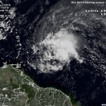
Dorian is a tropical storm that formed in the eastern tropical Atlantic ago. Dorian is probably going to head almost straight west-northwest and menace the vicinity north of the Greater Antilles and the Bahamas. This is going to take some time. By the end of the weekend, Dorian will be encountering islands in the northeastern Caribbean as a topical storm, most likely. The chance of Dorian remaining as a storm (as opposed to regressing to a depression) or strengthening from storm to hurricane is not at all large. But, unlike some others storms we've seen lately, Dorian seems to gain a little…
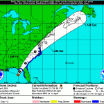
The first named storm of the Atlantic hurricane season has developed. Tropical Storm Andrea formed over the last several hours, and now exhibits winds of 63 knots at 5000 feet, with a surface intensity of about 50 knots, though these winds are only found in the "right hand" side of the storm, now sitting in the northeastern Gulf of Mexico. Most likely, this is all Andrea is going to manage as the storm moves north to make landfall, where it will also interact with upper level winds which will convert the storm to a big rain storm over the next day and a half. However, Andrea will be a very…
Things are mostly back to normal in DC today: Schools and government offices are open, trains and buses are running on their usual schedules, and there are few outward signs that Hurricane (or Superstorm) Sandy passed through here less than 48 hours ago. The situation is apparently far worse in New York and New Jersey, where flooding damaged millions of homes and hundreds of miles of subway tunnels. Millions of people from the Carolinas to Maine lost power, and many are still without it. The US death toll has reached 40.
With Election Day less than a week away, Hurricane Sandy reminds us how…
If you are in the path...the thousand mile wide path...of Hurricane Sandy, a.k.a. Frankenstorm, then you should make sure you know what the storm could do in relationship to where you are. If you are in or near an area with mountains, look for very serious flash flooding. The winds will be strong everywhere. If you are near the coast, be aware that the highest storm surges seen in years are expected in many areas. At the same time, it is important for those of us writing or talking about this storm to be realistic and careful in making predictions. This is becasue every case of dire…