Philippines

The outer reaches of Typhoon Hagupit are already affecting the target region in the Philippines. Hundreds of thousands of people have fled the areas most under the gun, but the potential for serious problems covers a very large area. The storm has gone through quite a few changes over the last couple of days, but is probably strengthening somewhat right now. No matter what happens, it is going to hit the Philippines as a very serious storm.
Jeff Masters has an update here.
This is the same area that was hit with Typhoon Haiyan last year. Haiyan was a bigger storm. But, Haiyan was also…

Typhoon Haiyan, which made landfall in the Philippines on Nov. 7, is another sobering reminder of the severe weather we are provoking through climate change. It is unofficially the strongest recorded cyclone to ever make landfall, with wind speeds up to 195 mph, 70% stronger than Hurricane Sandy. Villages are flattened, and more than 5,000 people are confirmed dead (as of 11/22). Greg Laden says that tropical cyclones feed on heat energy from the sea’s surface, from seas we know are getting warmer. Haiyan was a storm that blew past the most dire classification, Category 5, which tops out at a…
Ebola has long been associated with wildlife. From the early days, bats were viewed as a potential reservoir (though it wasn't confirmed that they actually harbored the virus until 2005). Contact with wild animals--particularly primates which were butchered for food--was also long thought to be a risk factor, and now we know that primates can become ill with Ebola and pass the virus to humans.
What hadn't been examined until 2008 were pigs. I mean, it's not exactly the animal you associate with central Africa, where many of the Ebola cases have been concentrated. However, pigs are much more…
August has been rather quiet for real volcano news, but I did find some more, well, odd news to mention. It is all volcano-related - to an extent - so here we go:
The new volcano-inspired Chivas stadium in Guadalajara, Mexico.
Last year we had the volcano mall in Italy, this year we have the volcano football (that is soccer for us Americans) stadium in Mexico (see above). The stadium in Guadalajara has green, sloping sides that that open to the "crater" that is filled with the pitch and the stands - seems fitting for a city in the middle of the Trans-Mexico Volcanic Belt. No word on what…

Mt. Hood in Oregon, taken August 2008. Image by Erik Klemetti. Click on the image to see a larger version.
Quick news!
I'm not going to go into too much depth right now about the recent study published in Nature Geoscience on Mt. Hood in Oregon - I plan to talk about it more in a few weeks. Why is that? Well, the lead investigator on the study, Dr. Adam Kent of Oregon State University, is a friend of mine (and occasional Eruptions commenter) so I plan to get the details from him before posting. I was also peripherally associated with some of this work - mostly in the field acting as a pack…
A few very quick hits:
Ever-looming Mt. Rainier, with Tacoma, Washington in the foreground.
PHIVOLCS is pondering whether to lower the Alert Status at Taal back to Level 1. The volcano has been on Alert Level 2 for the past month after increasing signs of potential eruptive activity. However, seismicity is down at Taal, so PHIVOLCS will be sending a ground team to do a survey before deciding whether to lower the Alert Level. The heightened state of alert at Taal has lead to some people taking advantage of the populace, with little more than a fake text message to cause panic.
Just how tall…
News for Monday!
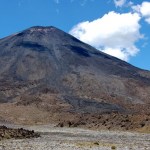
Ngauruhoe in New Zealand, showing the dark lava flows of basaltic andesite on the slopes of the young volcanic cone. Image by Erik Klemetti, taken January 2009.
A couple pieces of news from two Russian volcanoes on the Kamchatka Peninsula: (1) last week's report of activity at Gorely appears to be semi-substantiated with new photos on the KVERT website (Russian). The images from June 6 and 12 (2010) shows steam plumes coming from the volcano - one as tall as 500 meters. Now, this doesn't imply that an eruption occurred, but it might suggest activity on on the upswing. KVERT…
Volcano Island in the caldera lake at Taal.
The Philippine government is upping its concern about an eruption at Taal - and cracking down on tourists and resorts trying to get near Volcano Island in the volcano's caldera lake. Tourists are only allowed to take boat tours in the lake that go halfway to the island - which doubles as the most recently active vent at Taal - and if resorts on the lake bring tourists any closer, they may face repercussions from the government. Of course, this still isn't stopping tourists and natives from going to the island anyway. Now, one thing interesting to…
A partially-eroded scoria cone in the Taal volcano caldera.
As I mentioned earlier this week, PHIVOLCS has raised the Alert Status at Taal in the Philippines to 2 (out of 5) after increasing tremors and gas emissions from the volcano's crater lakes. Now, the Philippine government is taking this threat very serious, sending divers, helicopters, rescue equipment and medical teams to the area near the volcano in case an eruption occurs. Provincial officials in Batangas have asked 5,000 people living near Taal to voluntarily evacuate - however, as with many evacuations, people are reluctantly to…
The steaming vent area at Taal in the Philippines in September 1965, when the volcano produced a VEI 4 eruption.
The Philippine Institute of Volcanology and Seismology (PHIVOLCS) has raised the alert status at Taal to Level 2 (of 4) and officials in the Philippines are getting ready if the volcano does come back to life for the first time since 1977. Taal is a mere 48 km (30 miles) from Manila - the capital of the Philippines and home to over 21,000,000 people in the metro area of the city. This location made Taal one of the UN/IAVCEI Decade Volcanoes as a large eruption from the volcano…
Quick hits for a Monday morning (however, the week did have a good start).
Lava fountaining on March 27, 2010 at the Eyjafjallajokull-Fimmvörduháls eruption in Iceland.
The Eyjafjallajokull-Fimmvörduháls eruption is still going strong with two active fissure - and a lot of tourists poking around as well. If you watch the webcams closely, you can even see the cars and hikers trekking up near the erupting basaltic fissure (except today, as there seems to be a blizzard). Not to say that people are getting a little, well, nonchalant, but there is a story of serving meals cooked on lava up…
Some news for a busy Tuesday:
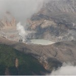
The crater at Poas volcano in Costa Rica, taken February 25, 2010. Image courtesy of OVSICORI by Federico Chavarria.
After the MSNBC debacle, it is nice to see some good articles on why the Chilean earthquake was overall less disastrous than the Haitian earthquake, why the tsunami wasn't as large as predicted and why these earthquakes are not abnormal. There are a lot of factors involved - the location, depth, preparedness, wealth - so the comparison can be very telling in terms of both geologic and societal issues.
The other scientific fallout from the Chilean…
A couple bits of news:
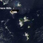
The ash plume from the February 11, 2010 eruption of Soufriere Hills taken by theAqua MODIS camera. Image courtesy of the NASA Earth Observatory.
Flights have been disrupted in the West Indies since last week with the large dome-collapse eruptions of Soufriere Hills on Montserrat. The 10 km / ~35,000 foot ash plume is apparently lingering in the air at commercial flight levels, meaning delays, cancellations or long detours for many flights in the area. Flights in and out of Dominica, Guadelope, Montserrat, Anguilla, St. Kitts and Nevis have all been effected by the…
Somehow I haven't posted a bunch of interesting items collected over the last few weeks, so I need to catch up. A pre-emptive hat tip to everyone who has sent me links or notes that might seem familiar in this post.
Tungurahua in Ecuador erupting in 2000.
First off, those of you looking for information on the Haitian earthquake that devastated the capitol Port Au Prince, Highly Allochthonous has post on the tectonics of the quake. Right now, it is hard for me to come up with a worse location in terms of devastation for a quake to have hit in the Caribbean Basin.
Back in volcano news, a lot…

The steam plume from Turrialba on December 26, 2009. Image by Eruptions reader Sahrye Cohen.
Turrialba
Costa Rican officials extended the evacuation zone around Turrialba from 3 to 6 km, raising the alert status at the volcano to Yellow. Vanessa Rosales of the National Emergency Commission described the seismicity as "intense but low," but says the country is prepared to deal with the emergency. As always, the news chooses oddly what is the "news" of an event, and many article on Turrialba focus on Costa Rica's coffee - yes, it is safe, so far. A news report from the Tico Times quotes Raul…
Two volcanoes down, two volcanoes up!
Fire fountain on Nyamuragira in the Congo, January 2010.
Down
Mayon
Activity at Mayon has continues to drop - although PHIVOLCS warns that an eruption could happen at any moment and without much warning. About a quarter of the evacuated families have no returned home since PHIVOLCS gave the OK to return home on January 2 - but Philippine officials are still on alert in case evacuations have to be reinstated.
Redoubt
The resurgent Redoubt is no long ... er ... resurging? AVO lowered the alert status to Green - meaning normal/background levels of activity…
A pile of news for the new week!
The glow of new lava flows from Nyamuragira in the Congo, taken from the Virunga Park Headquarters, January 2, 2010.
Mayon
PHIVOLCS may lower the alert status at Mayon to Level 2 after almost a week of lower seismicity and no ash explosions since December 29th. Schools that were being used as evacuation centers were also returned to teachers and students for the start of classes after the Christmas holiday. However, the Albay provincial government is now considering a plan to permanently move everyone who lives within the 6-km danger zone around Mayon, even…
2009 is over! If you missed the Volcanic Year in Review, check out my summary of the volcanic events that captivated many of us over the past year. However, only one event will get the coveted 2009 Pliny for Volcanic Event of the Year. A lot of you wrote in with votes and comments - I thank you - and a number of events stood out in your mind. Here we go:
Honorable mention
A few volcanic events got multiple votes:
- Soufriere Hills on Montserrat.
- Mando Hararo in Ethiopia.
- Chaiten, Chile and the new research on the eruption.
- The earthquakes in western Saudi Arabia under the Harrat…
Here it is, my attempt to recap a year's worth of volcanic events. By no means is this supposed to capture every event, but rather the highlight/lowlights and what most captivated me during 2009. I'll be announcing the winner of the 2009 Pliny for Volcanic Event of the Year tomorrow.
Waimangu Geothermal Valley in New Zealand, taken in January 2009 by Erik Klemetti.
January
The year started out with a trip to New Zealand (well, for me at least) and vistas of the Waimangu Valley, formed in the 1886 eruption of Tarawera on the North Island. We were also still thinking about the late 2008…
Not much new to report today, so I'll just add some notes to the two volcanoes in the news right now: Mayon and Redoubt.
Mt. Redoubt in Alaska, taken on September 23, 2009. Image courtesy of AVO/USGS, taken by Game McGimsey.
Mayon:
The volcano continues to show signs that a major eruption is in the works, but nothing new occurred over the last 24 hours. 2 km / ~5,000 foot ash plumes were produced from the new dome/flow complex, causing a potential aviation hazard, and the lava flows continued to be erupted. In evacuation news, animals are now being evacuated from the hazard zone around the…