Satellite images
It has been rather quiet on the volcano-front in the last week. Redoubt and Llaima (in spanish), after a few weeks of intense eruption, are both back on Orange Alert. News of the eruptions from Hunga Tonga Hunga Ha'apai and Fernandina is rather sparse in the details. The news of volcanism in 2009 seems to have settled down.
A few tidbits I caught over the weekend:
Chaiten
Damage wrought by the eruption of Chaiten on the town of Chaiten in Chile, taken in early December 2008. Image courtesy of the NASA Earth Observatory.
Don't you feel like you're read this sort of story before after other…
The weekend is rolling in and I might end up spending most of it in the 90+ degree California weather, so unless something big comes up (volcanically), I'll leave you with a few news bits.
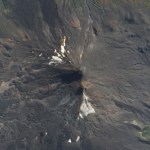
Llaima
Llaima in April 2009. Image courtesy of the NASA Earth Observatory
This is a true color image of Llaima in Chile, provided by the great folks at the NASA Earth Observatory. You can clearly see the dark grey new tephra on the main summit cone along with the grey ash covering the snow on the southwestern part of the volcano (north is up). A few other fun features are some smaller parasitic cones in…
Fissure vent eruption from Fernandina in the Galapagos Islands.
In news that comes as a surprise to no one, the current eruption on Fernandina in the Galapagos is having some adverse effect on the wildlife in the Pacific archipelago. Numerous dead fish and sea lions have been seen in the ocean near the actively erupting volcano - now, what exactly is causing the deaths is more speculative. I would imagine with the large plume being produced by the volcano, along with the lava flows reaching the ocean, that volcanic gases and the lava's interaction with the sea water might be the leading…
Mount Pagan in the Mariana Islands erupting on April 15, 2009. Image courtesy of the NASA Earth Observatory.
Up until fairly recently, a lot of volcanoes got away with erupting without anyone knowing the better. However, with all the "eyes in the sky" we have these days, even remote oceanic volcanoes get caught in the act of erupting. Case in point is this image (above) of Mt. Pagan in the Mariana Islands erupting. It was captured by the MODIS satellite yesterday and it shows a health ash plume emanating from the volcano. Pagan is an oceanic stratovolcano on the sparsely populated island of…
Chaiten erupting on January 19, 2009. Image courtesy of the NASA Earth Observatory.
It is hard to believe that we are less than one month away from one-year anniversary of the beginning of the eruption at Chaiten (and with it, the one-year anniversary of this blog!) The volcano in southern Chile is still erupting away, creating at least 2 dome complexes within the older caldera. These domes have been experiencing periodic collapses, creating block & ash flows, some of which have made it out of the caldera and down close to the ghost town of Chaiten. Along with the block & ash flows,…
Fernandina volcano in the Galapagos.
Fernandina in the Galapagos has entered a new eruptive phase according to the Geophysical Institute (GI) at the National University of Ecuador (in spanish). Satellite images show a new crater and ash column from the volcano and the GI will look for evidence of new lava flows beyond the "hot points" spotted on the satellite images.
UPDATE 4/11/09 9PM: I thought I'd add a link to the story in English now that I found one. There are also some pictures of the lava flows from La Cumbre (There is some confusion about name - Fernandina and La Cumbre are the…

Llaima in Chile, taken on April 9, 2009. Image courtesy of the NASA Earth Observatory.
The NASA Earth Observatory (currently celebrating its 10th year) has posted a number of great images of the current eruption of Llaima in Chile, taken from Earth Observing-1 and Terra Satellites. They show both the ash plume of the eruption and the lava flows associated with it (above). The image here is a false-color image of Llaima, where the bright red/orange is the lava flow from the volcano, along with the dark brown of the ash/rocks from this and previous eruptions.
The eruption itself might continue…
Popocatépetl from the ISS on January 23, 2001
It might be (and is likely) just normal behavior for Popocatépetl in Mexico, but the volcano produced six plumes over the last 24 hours, according to a report out of Mexico City (in spanish). Officials from El Centro Nacional de Prevención de Desastres (The National Center for the Prevention of Disasters - Cenapred) say that the plumes appear to be mostly water vapor and other volcanic gases, but remind people living near the volcano to be vigilant.
Popocatépetl is only 70 km from Mexico City, so any major eruption from the volcano could…
Image courtesy of AVO/USGS by Cindy Koplin showing the ash fall in Homer, AK on 4/4/09
Not much new to report about the eruption at Redoubt beyond the fact that it continues. AVO has kept the warning level at Red/Warning after briefly dropping it to Orange/Watch on Friday night. The 15,000 foot / 5 km-tall plume on Sunday was mostly water and volcanic gases. Eagle-eyed observers also noticed a plume on the lower flanks on the north side of the volcano that is believed to be steam generated by block & ash flows interacting with snow or water. These flow block & ash flows are coming…
Image courtesy of AVO/USGS by Ron Beck. Shows an ash plume from Redoubt (tan) on March 26 from a Landsat 5 satellite.
I'll be "off the grid" for the weekend at a wedding, so I thought I'd leave this open for any Redoubt news Eruptions readers hear over the weekend. Feel free to leave comments about the developments up in Alaska.
Currently, AVO reports that seismicity is lower since the eruptions this morning. They indicate that eruptions will likely occur without warning from here on in.
There are also some new articles on how the eruption is affecting air travel, including cancellations of…
Image courtesy of AVO/USGS by Game McGimsey
Following the provided script, Redoubt erupted again last night, producing a 32,000 foot / 10,000 meter ash column that prompted a new ash fall warning for the Kenai Peninsula area. Thus far, though, there have been few reports of major damage being caused by the ash fall. Alaska Air has yet to resume flights to Anchorage due to the ash, but will be reassessing as the day goes on. Since then, the seismicity has settled and we can wait for the next explosion. 2 PM Alaska time? Sounds good to me.
I want to point everyone to the great video montage…
Image courtesy of AVO/USGS
AVO has posted a series of images taken around Redoubt and around the Cook Inlet since the new eruptions started the night of March 22nd. You can begin to see the extent of the ash fall, what the explosions have done to the Drift Glacier and the new deposits in the Drift River valley. Most of the images show a lot of meltwater mudflows and tephra deposits on the slopes of the volcano. They've also added images from satellite and radar sources that show the initial dispersal of ash from the eruptions throughout the area north of Redoubt.
Eruptions reader Akira…
Mixing volcanoes and oceans seem to always produce exciting results. Whether it is something as simple as the ocean entry of a lava to something as impressive as a new island emerging, formed by volcanic eruption. Back in the 1960s, a previous unknown undersea volcano off the coast of Iceland erupted to form the island of Surtsey. The signs of the impending eruption were captured from start to finish, with Icelandic fisherman noticing "boiling seas", then steam explosions, then ash eruptions and finally volcanic tephra that formed the island itself. This was followed by lava flows and…
Image from keizo/weblog
Hunga Tonga-Hunga Ha'apai (how's that for a name?), a shallow seamount in Tonga, appears to have erupted. An air passenger snapped some pictures of an eruption occurring in the ocean between the Tongatapu and Vava'u and pilots in the area report that (unsurprisingly), the feature is new.
Hunga Tonga-Hunga Ha'apai - at least the part above water (look in the bottom of the image, the islands are marked in green) - is made of two small islands that cap the main seamount and ring the volcano's caldera. The last known eruption from the volcano was in 1988 - over twenty…
I found this little press release that doesn't have a huge amount of information, but is interesting nevertheless. The Coordinating Committee for Prediction of Volcanic Eruptions of Japan (nice name) is putting seven volcanoes on "24/7" monitoring. That sounds like we might see a lot of eruptions in Japan soon ... except that their rationale was that these volcanoes "are likely to affect public life by erupting or becoming active in the coming 100 years". That is quite the window of eruptive opportunity! The question is what exactly "24/7" monitoring - does this mean that someone/…
The NASA Earth Observatory website posted this great image of Redoubt taken from Landsat images in 2000.
You can see a few neat things. The main thing I notice is that the Drift River Oil Terminal is in about the worst place you could put an oil terminal near a volcano like Redoubt. All the material from recent eruptions at Redoubt get focused down into the Drift River, which then heads off into the Cook Inlet via the Drift River flood plain (upper right hand side of the image). When this image was taken, the Drift River is still grey with volcanigenic material even 10 years after the last…
It is hard to believe that the eruption at seem to come out of nowhere at Chaiten started over 8 months ago now, and apparently is still not showing many signs of abating. I did get a chance to see some great talks and posters at AGU last month about the Chaiten eruption, with the key points I took away being that Chaiten is erupting a very crystal poor rhyolite (<1% crystals) and that it seems that the source of the magma is relatively deep in the Andean crust. Also, there are some indications that the eruption at Chaiten may have been tectonically instigated - i.e., that earthquakes in…
The latest eruption of Sourfriere was captured from space, and NASA has just released the MODIS picture of the volcano in action. The image (above and linked) was taken 2 days after the first explosion of this unanticipated and unexpected eruption - December 4. You definitely get the idea of how much of the island of Montserrat is taken up by the volcano itself (pretty much all of it). Not much else to report on Soufriere Hills beyond the update from MVO (via SI/USGS) for the end of last week:
On 3, 4, and 5 December small, relatively slow moving pyroclastic flows traveled no…
So, I get a steady diet of email messages here at the Eruptions HQ, so I thought I could try a little roundup of the great information/links that you readers are sending (and I apologize for taking so long for some of these). Enjoy!
- Tim Stone tells us about GeoEye pictures of volcanoes. GeoEye is the new satellite launched to add to the Google Earth images of the planet. There are some quite striking images of volcanoes included in the collection.
- Richard Roscoe sends us to some updated images of the on-going volcanic activity on Montserrat. As usual, there is an abundance of…
El Reventador, the composite volcano in Ecuador, has been producing explosions and ash for the last few days, so says reports from the country's  Geophysics Institute. El Reventador is only 100 km from Ecuador's capitol, Quito, and in 2002 the volcano blanketed much of the city in ash. However, the eruptions currently occurring are much smaller and limited in scope, producing ash and throwing incandescent blocks out near the vent (see above). No evacuations are currently planned. These types of eruptions are typical for El Reventador since 2002, with increased activity…