Satellite images
Actually, no the volcanoes aren't from space, but pictures of the volcanoes were taken from space. The NASA Earth Observatory has posted three more gems of volcanic activity taken by one of the fleet of earth imagers in orbit:
A recent image of Chaiten taken by EO-1. Image courtesy of the NASA Earth Observatory.
There is a great image of the busy Kamchatkan Peninsula, where four volcanoes are seen erupting in a single image - Kliuchevskoi, Bezymianny, Shiveluch and Karymsky. The plume from Karymsky is especially prominent as a grey streak above the white snow of the Russian winter (albeit…
Quick hits for a Monday morning (however, the week did have a good start).
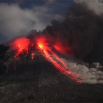
Lava fountaining on March 27, 2010 at the Eyjafjallajokull-Fimmvörduháls eruption in Iceland.
The Eyjafjallajokull-Fimmvörduháls eruption is still going strong with two active fissure - and a lot of tourists poking around as well. If you watch the webcams closely, you can even see the cars and hikers trekking up near the erupting basaltic fissure (except today, as there seems to be a blizzard). Not to say that people are getting a little, well, nonchalant, but there is a story of serving meals cooked on lava up…
Mars Reconnaissance Orbiter image of a potential plume on Pavonis Mons.
There are reports tonight that the Mars Reconnaissance Orbiter photographing the Martian surface noticed an odd plume near the summit of Pavonis Mons. The initial guess was that this plume might have been fog or an new impact on the Martian surface, but the continued presence of the plume might suggest that it is not a transient feature. One suggestion is that these could be a volcanic plume.
Now, Mars has been very volcanically active in the past - in fact the youngest flows could be as young as 20 million years old, so…
Alright, I'm actually in Wisconsin right now for a wedding, but this was too cool to pass up ... the folks from the NASA Earth Observatory sent me this image (Natural-color, 10m/pixel) from the Advanced Land Imager aboard EO-1 of the Eyjafjallajokull-Fimmvörduháls eruption, both taken on March 24, 2010.
The Fimmvörduháls eruption in Iceland, taken March 24, 2010. Image courtesy of the NASA Earth Observatory. Click on the image for a larger version.
You can clearly see the flow heading down the drainage to the east, slowly snaking down the snow covered area. I think the steam plume on far…
I'm still playing catch-up after my week in the desert, so I've seen a lot of articles I've wanted to mention ... but a certain other volcano has taken up a lot of my time. However, I will attempt to make amends for that now.
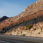
By the way, would you believe Ubehebe Crater was closed? How do they close a volcano, anyway? However, I did get a great snap of a welded tuff on the road outside of Shoshone, CA.
A strongly welded tuff near Shoshone, CA. The dark interior is remelted volcanic ash/tephra surrounded by less welded pink tuff with abundant pumice clasts. Denison student David Sisak is on…
Leaving for Death Valley tomorrow - I'll be sure to take some pictures of Ubehebe Crater and the volcano at the Mirage. This will likely be the last new post until about a week from now, but look for the Erta'Ale Volcano Profile, maybe a new Mystery Volcano Photo and I'll leave a thread open for any new volcano news.
Colima in Mexico.
Eruptions reader Tim Stone sent me this image from Japanese astronaut Soichi Noguchi's Twitpic feed - it is a stunner of the caldera on Jebel Marra in Sudan. The only known historical eruption for this volcano was ~2000 BC within the Deriba Caldera, but it has…
Did I mention its a busy week?
The lava lake at Erta'Ale in 2008. Image courtesy of Stromboli Online.
Our Icelandic saga continues, with more earthquakes and more speculation/information on the parts of Eruptions readers. Keep up the discussion - I'll be fascinated to see who turns out to get closest to what actually happens, prediction-wise. The seismicity has quieted somewhat again in the last 12 hours, so we wait eagerly to see what comes next. Remember, Iceland is the land where volcanoes helped change history, so it is always fun to talk Icelandic volcanism.
The NASA Earth Observatory…
Cleaning up some news ... busy week leading up to a field trip I am helping co-lead to Death Valley next week.
Ubehebe Crater in Death Valley, California
First off, I want to say how amazed I am at the great discussion that went on all weekend about the signs of potential activity in Iceland. It now appears that the earthquakes at Eyjafjallajökull may be waning, however the levels of seismicity have definitely bounced up and down over the last few days. However, the level and depth of the conversation is a testament to all volcanophiles out there. Nice job, folks.
For those of you into…
Not a lot of big news, but a lot of little news:
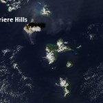
Soufriere Hills at night during the late January 2010 dome growth episode. Note the hot rock falls from the collapsing dome. Image courtesy of Photovolcanica.
This might not be new, but Dr. Boris Behncke brought the new webcam at the rim of Chaiten in Chile to my attention. You get a birds-eye view of the growing dome from the edge of the caldera - pretty nifty view for a once-in-a-hundred-years sort of event.
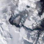
The NASA Earth Observatory has posted a close-up of the Soufriere Hills imagethat I posted yesterday, showing the February 11 plume.…
A couple bits of news:
The ash plume from the February 11, 2010 eruption of Soufriere Hills taken by theAqua MODIS camera. Image courtesy of the NASA Earth Observatory.
Flights have been disrupted in the West Indies since last week with the large dome-collapse eruptions of Soufriere Hills on Montserrat. The 10 km / ~35,000 foot ash plume is apparently lingering in the air at commercial flight levels, meaning delays, cancellations or long detours for many flights in the area. Flights in and out of Dominica, Guadelope, Montserrat, Anguilla, St. Kitts and Nevis have all been effected by the…
News!
Pakistan is home to the world's tallest mud volcano in the region of Balochistan - and its somewhat near the reports of an "eruption" earlier this week.
Guess what? Since Wednesday evening, seismicity at Yellowstone has dropped precipitously. The last batch of earthquakes on February 3rd were also back to deeper levels - 8-9 km depth - compared to the potential shallowing earlier in the week. I'm sure the caldera will keep us on our toes, but as of now, it seems to have settled down a bit.
Over in Pakistan, there is mounting evidence that the recent "volcanic" eruption reported as, in…
First off, I wanted to thank all of the Eruptions readers for making January the most popular month ever on this blog. I suppose I should give an assist to Yellowstone, but really, thanks for coming to the blog, reading the posts and engaging in all the great discussions that go on within its (cyber)walls.
KÄ«lauea's east rift zone eruption site. Image courtesy of the USGS/HVO.
On to some news!
I suppose you've made the big time when you're in the New York Times, and sure enough, the current Yellowstone earthquake swarm is in the Old Grey Lady. Nothing much new to read, but summarizes the…
Somehow I haven't posted a bunch of interesting items collected over the last few weeks, so I need to catch up. A pre-emptive hat tip to everyone who has sent me links or notes that might seem familiar in this post.
Tungurahua in Ecuador erupting in 2000.
First off, those of you looking for information on the Haitian earthquake that devastated the capitol Port Au Prince, Highly Allochthonous has post on the tectonics of the quake. Right now, it is hard for me to come up with a worse location in terms of devastation for a quake to have hit in the Caribbean Basin.
Back in volcano news, a lot…
2009 is over! If you missed the Volcanic Year in Review, check out my summary of the volcanic events that captivated many of us over the past year. However, only one event will get the coveted 2009 Pliny for Volcanic Event of the Year. A lot of you wrote in with votes and comments - I thank you - and a number of events stood out in your mind. Here we go:
Honorable mention
A few volcanic events got multiple votes:
- Soufriere Hills on Montserrat.
- Mando Hararo in Ethiopia.
- Chaiten, Chile and the new research on the eruption.
- The earthquakes in western Saudi Arabia under the Harrat…
Looks like last night was busy, volcanically speaking. Eruptions readers noted that VAAC warning of ash from both Mayon (to 10,000 feet / 3.0 km) and Bezymianny (to 32,000 feet / 10 km) were issued {hat tip to Chance Metz for the updates}. Here is some more news on these ongoing events:
Mayon erupting in December 2009.
Mayon, Philippines
Evacuations are continuing near Mayon in the Philippines, some of them forcibly by the local authorities. PHIVOLCS is reporting that SO2 output from Mayon has jumped from ~750 tonnes/day to almost 2,800 tonnes/day over the last 24 hours and seimicity…
It's the last week of classes and it's also AGU (which I will be missing for the first time in 5 years). If you happen to be at the big meeting in SF and hear something you think we'd like to hear, feel free to drop me a line or leave a comment so we can live vicariously through you.
Pyroclastic flows at Sourfriere Hills, December 2009. Image courtesy of MVO.
Some news:
UPDATE 12:40PM 12/14/2009: Just to update the Mayon news from earlier today, PHIVOLC is reporting that lava has been spotting flowing from the main crater on Mayon. Sounds like the eruption we've been waiting for is…
Busy times at the end of the semester right now ...
Concepcion seem from the ISS in 2007. Image courtesy of the NASA Earth Observatory.
One brief bit of news:
Concepcion in Nicaragua erupted, covering three nearby villages with ash. The brief report only mentions 150 meter / 400 foot explosion columns from the eruption, which makes me thing this is merely for the ballastic clasts. No other details - on the eruption or any evacuations - are available.
Concepcion is in the middle of Lake Nicaragua on the island of Ometepe (and the original Mystery Volcano Photo). The volcano last erupted in…

Maybe I should just apologize right here and now for that title, but dang, I liked it.
Anyway, I've seen a lot of plume images cross my browser/inbox over the last day, so I thought I'd post a few of them.
Soufriere Hills, Montserrat
The renewed activity at Soufriere Hills has produced a bounty of plume images over the last week. The NASA Earth Observatory posted an image of the plume, which sometimes reached as high as 3.7 km / 12,000 feet (if not higher). Eruptions reader Alex Waning sent me some images of the top of the plume at ~3.7 km / 12,000 feet taken from a flight near Montserrat on…
An ash plume from Soufriere Hills on Montserrat, taken from the ISS on October 11, 2009.
If you ever wonder what might happen to the U.S. if a large volcanic eruption, lets say from Rainier or Long Valley or Shasta, occurred, you can look at the island of Montserrat for some of the potentials problems. The renewed activity at Soufriere Hills (video link) that started in October is causing problems with the power infrastructure of the island - specifically the ash from the eruption is falling on power lines and damaging them. Ash has a minor electrical charge, so it will coat anything with a…
Back to work after Thanksgiving Break ... lets clean up a few news items I missed trying to figure out the non-eruption of Karkar.
Undated photo of the summit area of Gaua, Vanuatu.
There was an actual eruption - or, more correctly, a continued eruption - of Gaua in Vanuatu. The current activity has prompted the evacuation of 300 villagers from the island and they will not be able to return until activity wanes. Tourists were also told to stay away from the volcano, but the airport on the island has not been affected by the eruption, which might suggest the activity is relatively localized…