seismicity

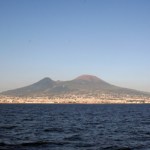
Redoubt steaming in early 2009. Image courtesy of Calvin Hall.
It has been a while since we spoke of Redoubt, but now it seems the reason why might be that the eruption is ending. AVO lowered the Alert Level at Redoubt to Yellow from Orange, indicating that they believe the volcano is less likely to have a large eruption. This doesn't mean that it is out of the question, but rather that signs seem to be pointing to the idea that the eruption is waning.
AVO sums the change:
Seismic, satellite, gas, and deformation observations over the past few weeks indicate that growth of the lava dome at…
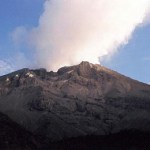
The latest in my Volcano Profiles Series, we turn to Europe and Vesuvius. You could fill many, many volumes with the works produced on Vesuvius since Roman times. This profile will barely scratch the surface when it comes to the vast geologic and human history surrounding the volcano, but it is a start. If you want to learn more about the archaeology surrounding Vesuvius, try visiting Blogging Pompeii.
VOLCANO PROFILE: MT. VESUVIUS
Mt. Vesuvius in Italy. Image courtesy of Dario Leone.
Location: Italy
Height: 1,281 m / 4,203 ft
Geophysical location: The tectonics in the Mediterranean are…
One brief note before I head out the door ...
Fissures formed in western Saudi Arabia during the earthquake swarm near Harrat Lunayyir during May and June 2009. Image courtesy of Ahmed Al-Hussaini.
The earthquakes in the Harrat Lunayyir region of western Saudi Arabia seem to be like a character out of Monty Python and the Holy Grail: they're just not dead yet. Two more earthquakes, these in the M3 range at 8-9 km depth, hit Thursday morning, further delaying the return of evacuees to the Al-Ais region. This bring the total earthquakes to over 150 since seismicity began a few weeks ago.…
This week's edition of Wednesday Whatzits could have been called "Miércoles Materia" as all the updates are for South American volcano. Enjoy!
Tungurahua in Ecuador
(Note: all links in spanish)
INGEOMINAS in Colombia is reporting that Nevado del Huila experienced 343 earthquakes over the past week, suggesting that something is brewing at the volcano. This has been accompanied by gas emissions and ash from the fractured dome. The Volcano Observatory in Popayán mentions that more than half of the earthquakes are related to magma moving into the system. Huila remains at Level III (Yellow)…
Turrialba volcano in Costa Rica.
Turrialba, one of Costa Rica's active volcanoes, is apparently showing signs of life according to a brief report by Teletica 7 (in spanish). There is increased seismic activity and elevated gas emissions at the volcano that last erupted in 2007* and 1866 prior to that. The fumarolic activity at the summit crater is not a new occurrence, however the report implies that it has gotten more intense as the volcano has experienced increasing seismicity since early May. The Volcanism Blog does have an excellent summary of the rumblings at Turrialba since earlier in…
Fissures formed by seismicity in the Al-Ais region of Saudi Arabia. Image courtesy of Ahmed Al-Hussaini.
Although it seemed last week that the earthquakes in western Saudi Arabia were subsiding last week, there have been a number of reports that there was still significant seismicity in the area over the weekend. Earthquakes in the M2.5-3.5 range occurred on Saturday - both of which the SGS are attributing to "subterranean volcanic activity." This has prevented the evacuees from the Al-Ais region to return to their homes. The Saudi government has begun to assess how much effect this activity…
Here's some news bits for all you volcanophiles. Enjoy the weekend!
Ubinas in Peru steaming away in June 2007. Image courtesy of Eruptions reader Mike Lyvers.
There has been a lot of press lately on the theory that a large eruption from an ancient volcanic field in China (the 260-million-year-old Emeishan volcanic province of southwest China) could be the culprit in the grand Permian extinction. I have to admit, I've only skimmed the surface of this study, but the work lead by Dr. Paul Wignall (a paleontologist, not a volcanologist - not that there is anything wrong with that) seems to…
You'll have to excuse the curtness of this post. An bad hop in softball will do that to you.
Here's some news:
Mt. Dempo in Indonesia
Xinhua offers some nice pictures of the current activity going on at the summit crater at Nyiragongo in the Congo. Note the partially-crusted-over lava lake in the first shot. The Red Cross is updating the evacuation and mitigation plans for the area as the volcano shows increased activity.
The alert level at Mt. Dempo in Indonesia was raised to the second highest level. There has been ash fall (as far as 10 km from the vent) and volcanic gas emissions. The…
Al-Qider volcano in western Saudi Arabia. Image courtesy of Ahmed Al-Hussaini.
After a week's worth of worry, it appears that the seismicity in western Saudi Arabia is subsiding. The latest statement from Zuhair Nawab, the head of the SGS, is that over the past four days with fewer and less severe aftershocks. If this continues, people who have evacuated the area around Al Ais might be able to return to their homes in a few days. However, it is important to note that even though officials suggest the seismicity is waning (and there may be indications this is not entirely accurate), the swarm…

UPDATE 5/21/2009 4:30 PM Pacific: The latest news suggests that there are little to no evidence of volcanic gases since Wednesday according to the SGS, but they continue to monitor.
Lava flows from a 1256 A.D. eruption near Medinah in Saudi Arabia (to the south of Harrat Lunayyir) taken by the crew of the ISS in 2004. It shows nicely the volcanic heritage (dark lava flow on right of image) in western Saudi Arabia. Image courtesy of JSC Earth Observation Lab.
Well, as the days go by, there are more and more indications that an eruption is about to occur in the Harrat Lunayyir region of Saudi…

I have finally gotten together enough to create a Google Earth image (below) of the location of the Saudi Arabian earthquakes and their depths/magnitudes. I only have the data from the USGS earthquake list, but it is very illuminating:
Harrat Lunayyir volcano in western Saudi Arabia from Google Earth with the current earthquakes shown on the image. Image courtesy of Google, earthquake data from the USGS. Click here to see a larger version.
The earthquakes look like this (all times are Universal Time):
Date Time Mag. Depth
5/17 19:50 M4.6 10 km
5/19 06:38 M4.9 10 km
5/19 16:54 M4.9 10 km
5/19…
Al-Qider volcano in western Saudi Arabia. Image courtesy of Ahmed Al-Hussaini
The intense seismicity occurring underneath the Al-Eis region in Saudi Arabia has reached a point where Saudi Arabian officials are requiring 60,000 people who live in the region to evacuate. This is after M4.6 and M5.4 earthquakes that occurred Tuesday night (Saudi time). Saudi officials have also begun to build shelters for people affected by the earthquakes.
Now, the direct connection to a potential eruption is still very much in the air, but the earthquakes are still centered underneath known Holocene volcanic…
Al-Baidha volcanoAl-Qider volcano in Saudi Arabia. Image courtesy of Ahmed Al-Hussaini.
I've been searching for more information on the Saudi Arabian earthquake swarm reported last week. A number of Eruptions readers have also added some on-the-ground info as well.
UPDATE 12:30PM Pacific: Here is a brief update via Reuters India. They mention that five villages are being evacuated as a precaution. Beyond that, not much new information and it does feature this line that makes me shudder: "The region lies on a fault line, according to SGS, which declined to comment on current magma levels,…
Volcano news ahoy, today brought to you by Islands.
Lake Kivu, located along the border the Democratic Republic of the Congo and Rwanda
A gorgeous satellite image (brought to us by the NASA EO) of a steam plume and ash from the ongoing eruption at Shiveluch in Kamchatka. The ash distribution stands out remarkably well on the white snow, with the central circle of ash near the vent/dome and then the wind-aided ash blanketing the terrain to the northeast of the volcano (and a little bit to the south).
Nature has a post reminding us that one of the big hazards at Nyiragongo/Nymuragira is not…
The Harrat Khaybar volcanic field in Saudi Arabia. Image courtesy of NASA, taken in 2008.
Now, I might take this report with a Volvo-sized grain of salt, but I've seen a few reports lately of an earthquake swarm going on in Saudi Arabia, near the Harrat Ash-Shaqqah in Al-Eis region (apparently near Madina, but I'm not 100% sure). I might normally just chalk this up to the tectonics of the Arabian Plate, however, the latest article I read this morning, Saleh Al-Muhawis, Director General of the Civil Defense in Madina Region mentioned this as the cause of the seismicity:
... magma (molten…
The Geysers Geothermal Power Plant
Eruptions reader (and former hallmate at Oregon State) Ed Kohut sent me a message today pointing out that there is an ongoing earthquake swarm in the area of the Geysers in northern California. Now, I don't know what the normal seismicity is underneath the Clear Lake area and this area is part of the San Andreas fault system, so these earthquake are likely not volcanically related, but I post them here just as a reminder of how difficult it can be to deconvolve these geologic signals.
The Geysers are part of the Clear Lake volcanic region, which is still…
Chaiten erupting in May 2008. Image courtesy of ONEMI.
Speaking of anniversaries, this weekend is the one-year mark for the Chaiten eruption (in spanish) in Chile, the first eruption at the volcano in ~9,000 years. Yes, indeed, the rhyolite eruption that caught most everyone by surprise is still going strong one year later, with two domes growing within the caldera (in spanish). The eruption produced some of the most impressive and sustained ash columns in years (see below) - climbing to 16 km/9 mi, abundant lahars and pyroclastic flows from the emergence and growth/collapse of the domes and…
Mt. Barujari erupting in 1994. Image courtesy of Vulkaner.no.
Sometimes it is hard to appreciate how many volcanoes lie within Indonesia. However, within the last few weeks, no less than four Indonesian volcanoes have been put on alert to eruption or shown increased signs of activity - Slamet, Kirinci, Anak Krakatau and now Mt. Rinjani (above).
UPDATE 5/3/2009 11AM (Pacific): The volcano is erupting according to the Jakarta Globe. Seems like the activity so far is confined to small explosions emitting ash and gases. More info as I find it.
Rinjani is a popular tourist destination on the…
The weekly USGS/SI roundup is out. Highlights (beyond Slamet) include:
Explosions (some heard 25 km away) and incandescent blocks that started fires at Galeras, Colombia.
Ash and tephra being thrown tens of meters into the air and a 4-m tall spatter cone being built at Pacaya, Guatemala
Also in Guatemala, Santa Maria's Santiaguito dome produced ash plumes and explosions.
Steam, ash and sulfur odors from the continuing eruption at Redoubt, Alaska.
Increased seismicity, steam and ash plumes along with a thermal anomaly at El Reventador in Ecuador
Mt. Slamet, Indonesia, with agricultural fields in the foreground.
I'll be brief, mostly because I'm still lost in a haze of jetlag and allergies, but ...
Mt. Slamet on the island of Java in Indonesia is showing signs of a "major eruption". Preparations have begun by the Indonesian government to evacuate people in the event that the volcano erupts, however, it is unclear when that might be. Agus Budianto, head of the volcanology unit at the Bandung, West Java-based Volcanology and Disaster Mitigation Agency, said this about the current activity at the volcano:
"Even though the earthquake…