united states

Left to right, Granny Beck, my Grandma June, and Great-Great Grandma Bertha, circa 1961. Who knows what was on the menu that day.
My Great-Grandpa and Granny Beck were, in some ways, ahead of their time. My Grandpa’s mom and step-dad, they both went through scandalous divorces and then switched partners with another couple, Granny Orpha marrying Wade and my Grandpa’s dad Lee marrying Wade’s ex-wife, Edna. Orpha and Wade raised 5 of Orpha’s boys together, and had a daughter after the divorce/remarriage.
By the time I was born, my Granny Beck was in her 80s, and I have only vague…
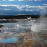
I am back from our trip into the Mountain West - and it was great (see some of the pictures below). We hit Yellowstone, the Grand Tetons, the Tobacco Root Mountains, Glacier and Craters of the Moon - and the weather held out on us just fine.
This week is the last week before classes start here at Denison, so post might be a little sparse this week ... and next week will bring something big to Eruptions, so stay tuned. I'll try to post some news soon as I get caught back up with what has been happening (including all the Katla talk). Special thanks again to Boris Behncke for the great Etna…

Mt. Hood in Oregon, taken August 2008. Image by Erik Klemetti. Click on the image to see a larger version.
Quick news!
I'm not going to go into too much depth right now about the recent study published in Nature Geoscience on Mt. Hood in Oregon - I plan to talk about it more in a few weeks. Why is that? Well, the lead investigator on the study, Dr. Adam Kent of Oregon State University, is a friend of mine (and occasional Eruptions commenter) so I plan to get the details from him before posting. I was also peripherally associated with some of this work - mostly in the field acting as a pack…
Lots of little pieces of news I've run across ... time to play a little catch up.
Stromboli: A volcano after Don Ho's heart.
Every once in a while, my RSS feeds will dredge up some articles from years gone by ... and this week there were two New York Times pieces that are a few years old, but interesting nevertheless. The first is about research conducted by Dr. Robert Sohn at WHOI on explosive undersea eruptions. The second is work by Corr and Vaughan about finding subglacial volcanism in Antarctica. Both are interesting reads if you missed them (like I did) the first time around.…
Lava flows from Kilauea in Hawai`i move towards a home in Kalapana.
Whenever I think about the hazards posed by most lava flows, I tend to think about the opening scene in the Hitchhiker's Guide to the Galaxy. Developers are planning to knock our hero Arthur Dent's house down and as a last ditch effort to stop its destruction, Arthur lies down in front of the bulldozer. The demolition supervisor, a certain Mr. Prosser, at one point asks Arthur if he knows how much damage the bulldozer might suffer if he just lets it roll over poor Mr. Dent. Arthur says he doesn't know and Mr. Prosser replies…
The northern Chilean and southern Peruvian Andes are full of volcanoes that look stunning - I mean, jaw-dropping details of volcanism litter the landscape. The reason for this is two fold: (1) there is an awful lot of volcanism in the northern Chilean/southern Peruvian Andes (as known as the Central Volcanic Zone) - and has been that way for over 10 million years and (2) it has also been very, very dry in the area (most of which is known as the Altiplano-Puna Plateau) for at least a few millions years as well - it is the home of the Atacama Desert! So, this means you get lots of volcanic…
Tourists hiking next to an active lava flow on Pacaya in Guatemala in 2006.
I'm flying back to Ohio today after a successful few weeks of fieldwork/paper writing. Apparently I have a pile of tomatoes waiting in our garden in Granville ... !
On to news:
To go with the news that lava flows from Kilauea creep ever closer to structures in Kalapana, the NASA Earth Observatory posts its first volcano image in a bit. The shot shows the steam-and-gas plume from the Halema`uma`u Crater in Kilauea's summit caldera. You can also see some video of the lava flows near Kalapana as they move along the…
Kilauea lavas on the move near Kalapana. Image taken July 17, courtesy of the Hawaiian Volcano Observatory.
Some news over the last few days:
The lava flows from Kilauea are moving with a vengeance right now, damaging roads and heading for some structures. The lava flows near Kalapana have moved almost 200 meters since Sunday, closing within 100 yards of homes in the area. The lava is moving to the east along Highway 130 and 137 - and tourists are making it difficult to get around as they park to watch the lava - upwards of 2,000 people! A number of people (and dogs) have had to be…
A few very quick hits:
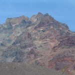
Ever-looming Mt. Rainier, with Tacoma, Washington in the foreground.
PHIVOLCS is pondering whether to lower the Alert Status at Taal back to Level 1. The volcano has been on Alert Level 2 for the past month after increasing signs of potential eruptive activity. However, seismicity is down at Taal, so PHIVOLCS will be sending a ground team to do a survey before deciding whether to lower the Alert Level. The heightened state of alert at Taal has lead to some people taking advantage of the populace, with little more than a fake text message to cause panic.
Just how tall…
Serpentine (as known as serpentinite), the current (and potentially soon-to-be ex-) state rock of California.
This does not have a direct connection to volcanoes, but it sure is about geology and the science in the news. State Senator Gloria Romero of California has sponsored a bill to change the California state rock from serpentine because, as she claims:
"[Serpentine] contains the deadly mineral chrysotile asbestos, a known carcinogen, exposure to which increases the risk of the cancer mesothelioma ... California should not designate a rock known to be toxic to the health of its residents…
So, I've had requests on the blog to help to do some defining of volcanologic terms on the blog, so I thought I'd try a new column called Eruptions Word of the Day. I'm not sure how often it will run, but let's give it a try.
Eruptions Word of the Day for July 5, 2010: Dacite
Dacite is a magma type defined by silica (SiO2) content between 63-68 (or 69) weight percent. That is the textbook definition, but some other typical characteristics of dacite lavas (or magmas) is the presence of certain minerals: plagioclase feldspar and hydrous minerals (containing water in their mineral structure)…
Have guests in town, so I'm a little busy, but you can hopefully keep entertained with the latest Smithsonian/USGS Global Volcanism Program Volcanic Activity Report.
Chile's Melimoyu volcano.
The highlights (not including Taal and Eyjafjallajökull) include:
Alaska's Cleveland volcano has been reduced to and alert status of "unassigned" (used when a volcano is not closely monitored so AVO doesn't know what exactly is "background") after a few weeks of activity. The same was done for the submarine volcano south of Sarigan in the Marianas Islands after no signs of activity since the eruption…
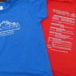
Last year I mentioned the fundraiser for the excellent Mt. Baker Volcano Research Center - and lo and behold, I will mention it again. The new 2010 t-shirts are out and you can purchase one to support one of the best volcano research sites on the web (and off the web) - with a plethora of information on Mt. Baker, updates on the research going on at the volcano and any news of activity from Washington's northern-most volcano.
2010 MBVRC t-shirt. Click to enlarge image.
This year's t-shirt features Mt. Baker's eruptive history (see above) and can be yours by visiting the MBVRC blog site. You…
Looking for some volcano news - you've found it.
A shot of volcano "tourists" near the erupting Pacaya. Photo by the Associated Press.
Eruptions reader Dr. Boris Behncke dropped a note that Kilauea has not one but two active lava lakes right now. The lava lakes can be seen on the webcams for the Halema`uma`u Crater and the Pu`u O`o flank vent. The latest status update from June 6th by the USGS Hawaiian Volcano Observatory talks about both the summit and rift activity (video) on Kilauea as well. Meanwhile, Hawaii 24/7 has a piece in the Volcano Watch series about whether residents of Maui…
The NASA Earth Observatory has been dazzling us with images from the Eyjafjallajökull eruption for months - but they have been dazzling us with volcanoes images for years! Here are two more images for those of you who love seeing volcanoes from above:
Cleveland, Alaska
As I mentioned earlier this week, Cleveland volcano likely had a small eruption over the weekend producing a small ash cloud. Cleveland is already known as an extremely picturesque volcano, both from the ground for its highly conical shape - a textbook andesitic stratocone - and from space. This new June 1 image is from almost…
The level of news-frenzy on some of the recent volcanic eruptions has died down, but if you're looking to see information on the many rumbling going on worldwide, look no further. Here is this week's Volcanic Activity Report put together by Sally Kuhn Sennert of the Global Volcanism Program.
Highlights - not including Pacaya, Yasur, Tungurahua and our friend in Iceland - include:
The eruption in the Marianas apparently came from South Sarigan volcano - at least according to the best guess by folks who work in the Marianas. This submarine volcano apparently shows evidence of young lava flows…
Tungurahua in Ecuador erupting on May 31, 2010.
Two volcanoes along the edge of the north Pacific had explosive eruptions over the weekend. We have some more details on both of the eruptions, so I'll pass them on:
Bezymianny
KVERT is excited because they claim to have predicted the explosive eruption of Bezymianny almost to the day. They had been closely monitoring the volcano and issued this statement on May 20:
According to satellite data by AVO and KVERT staff, a temperature of
the thermal anomaly over the lava dome of Bezymianny volcano began
increasing from May 19 (from -1 (9:49 UTC) to…
Quick news on Memorial Day (in the US at least):
Ash soaked by rain from Tropical Storm Agatha on the roofs of homes in Guatemala after the late May eruption of Pacaya.
Sixteen scientists were evacuated from islands in the northern Marianas due to the eruption of the unnamed submarine volcano south of Sarigan Island. The eruption is continuing to be monitored closely by the USGS and National Weather Service as the plume - which is most steam with minor ash - could disrupt air traffic in/around Saipan. The latest USGS CNMI update:
Seismicity at a single nearby station on Sarigan Island…
Sarigan Island in the northern Mariana Islands. An undersea eruption appears to be underway south of the island.
Thanks to the watchful eye of Eruptions readers, we had an inkling of this eruption the other day, but now we have confirmation that an undersea eruption is underway in the northern Mariana Islands. The exact volcano erupting is unknown, but it appears to be between Anatahan and Sarigan (see below) - both active volcanoes in the Marianas - at a depth of 300 meters. The eruption has been described by the USGS as hot water vapor and an ash plume that might have reached as high as 12…
Brief news!
Lava flows reaching the sea at Kilauea in Hawai`i. Image from November 2009, courtesy of HVO/USGS.
The Alert Status at Cleveland in the Alaskan Aleutian Islands was raised to Yellow (Advisory) by the Alaska Volcano Observatory after new signs of activity emerged. The latest report from AVO on the volcano says a thermal anomaly has been spotted at the summit, which typically is one of the first signs that the volcano is entering an eruption period. However, there is no real-time seismic monitoring for Cleveland, so that is the only clue (right now) that AVO has. Cleveland is a…