Lots of little pieces of news I've run across ... time to play a little catch up.
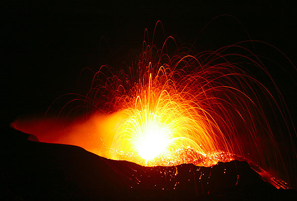
Stromboli: A volcano after Don Ho's heart.
- Every once in a while, my RSS feeds will dredge up some articles from years gone by ... and this week there were two New York Times pieces that are a few years old, but interesting nevertheless. The first is about research conducted by Dr. Robert Sohn at WHOI on explosive undersea eruptions. The second is work by Corr and Vaughan about finding subglacial volcanism in Antarctica. Both are interesting reads if you missed them (like I did) the first time around.
- Yesterday I talked about lava flows - and specifically the Kilauea lavas that are in the Kalapana subdivision. Here is the current update from HVO on the flows along with some details from the local news (link has video).
- We have a new Smithsonian/USGS Global Volcanism Program Weekly Volcanic Activity Report - again, filled with great information, including news from Rabaul, lava flows and a >6 km ash plume from Kliuchevskoi, and continuing strombolian activity at Pacaya.
- There was some news last week about recently published research on the mechanisms for eruptions at Stromboli. I haven't had a chance to digest it all, but the long-and-short seems to be to think about these eruptions like Don Ho would: "tiny bubbles". The original paper was published in the Journal of Geophysical Research.
- In case you haven't been visiting the NASA Earth Observatory page in a while, they posted an image taken last week of the current activity at Nyiragongo in the DRC. The image shows the sulfur dioxide-rich plume coming from the main summit crater.
- And there have been a lot of articles this week with airlines reporting the cost of the Eyjafjallajökull airspace closures. The reports are all in the tens of millions of Euros, but across the board, the airlines say ticket sales are back on track. Funny how quickly businesses recover after something like this eruption (even after all their wailing and moaning at the time).
Never heard of the
PITTSBURGH SUPERCOMPUTING CENTER
http://www.psc.edu/research/graphics/gallery/earthquake.php
maybe some of you find some interesting animations.
How about that:
"RVO reported an eruption from Rabaul caldera's Tavurvur cone on 23 July, after increased seismicity likely beneath Tavurvur cone was detected the previous day."
New Britain's sequence of EQs started after a 7.3 Sunday, July 18, 2010 at 13:34:59 UTC
and then, on July 23rd the sequence of deep Mindanao EQs.
No correlation?
BTW: Another 6.6 aftershock today in Mindanao.
(Data from USGS)
Renato: It's a bit difficult to correlate a specific Tavurvur explosion with the New Britain quakes, since Tavurvur has been banging and thumping away on a pretty regular basis for most of the last fifteen years. (check previous GVP weekly reports) But maybe it's not impossible that the quake could have given magma in the conduit a good shaking up and encouraged gas bubble formation
Rio, you read this: Tectonic Setting and Volcanoes
of Papua New Guinea, New Britain, and the Solomon Islands
volcano.oregonstate.edu/vwdocs/volc_images/southeast_asia/papua_new_guinea/tectonics.html
Think about Ekohs informative posts, my elaboration on the Mindanao deep focus EQs, the Russkie Model and the proof presented in the marvelous Cocos plate subduction and deep folding.
The map of volcanoes active from 1900-1999 is interesting. From what we know of this area, most of the recent volcanic activity makes sense, although it's a tectonically complex region.
And then there are the out-of-the-blue sleepers, like Lamington, with it's sole recent eruption occurring mid-20th century. It was a VEI 4, lasting several years with unfortunate pyroclastic flow deaths over a very large area.
volcano.oregonstate.edu/vwdocs/volc_images/southeast_asia/lamington.html
From John Seach: Lamington is a major andesite volcano located in an area without a Benioff-Wadati zone. The magmas erupted from the volcano have unusually high levels of Nickel and Chromium.
That observation came from a 1983 publication, 'Ophiolite-contaminated andesites, trachybasalts, and cognate inclusions of Mount Lamington, Papua New Guinea: anhydrite-amphibole-bearing lavas and the 1951 cumulodome.', which mentions,
'Mount Lamington, together with three other major andesitic centers â Mount Victory, Mount Trafalgar and Hydrographers Range â rest on a northeast-dipping ophiolite sheet, the Papuan Ultramafic Belt (PUB); there is no evidence for a Benioff-Wadati zone beneath this part of Papua.'
That caused a bit of difficulty for subduction zone modelers, but a new regional model,
New SW Pacific tectonic model: Cyclical intraoceanic magmatic arc construction and near-coeval emplacement along the Australia-Pacific margin in the Cenozoic. (AGU 2008 Wattman et al)
www.agu.org/journals/ABS/2008/2007GC001710.shtml
was published recently.
'A new model is presented whereby the PUB, New Caledonia, and Northland ophiolites formed and were emplaced in a cyclical fashion above an extensive NE dipping Cenozoic intraoceanic arc system which diachronously propagated (N-S) along the entire eastern margin of the Australian Plate.'
Chris, at Highly Allochonthous, has a great descriptive tectonic map of the region.
all-geo.org/highlyallochthonous/2010/07/fridayish-focal-mechanisms/
And that's what set us off exploring deep focus EQ mechanics. After reading our posts here, it should be a nobrainer to see the depth of these quakes and understand that stretching/thinning and folding quakes will be ongoing, once the Big Crackers released the potential energy of what must be a major fold forming.
An aside: for those who were met with the inevitable NYTimes login webpage after clicking his hyperlinks to the articles on Antarctic subglacial volcanism, see
www.science20.com/news_releases/first_evidence_of_sub_glacial_volcano_i…
and the original letter-article abstract by Corr and Vaughn, Nature Geoscience 1, 122 - 125 (2008), 'A recent volcanic eruption beneath the West Antarctic ice sheet'.
www.nature.com/ngeo/journal/v1/n2/full/ngeo106.html
@mike don #3: this was a speculation we were arguing about on that day of New Britain's quake. Just wanted to post this as a reminder. Thank you.
@Passerby: I haven't yet finished all my homework and you're already providing us with ever more precious information. I must confess it's a bit confusing to understand all mechanisms involved in plates/subduction over that specific area, but I'm getting closer. I'ts a big honor to have you here to help us. Many thanks.
Not to worry - the mention of Lamington was to point to the evolving understanding of the mishmash of plates and mechanisms at play in the New Britain-PNG area; SE Asia-South Pacific region IS tectonically busy - and confusing, if you don't tease it apart.
To pick up on the links above, to the research conducted by Dr. Robert Sohn at WHOI on explosive undersea eruptions, and the work by Corr and Vaughan about finding subglacial volcanism in Antarctica, I was interested to see the links between volcanism and global warming being explored. It is not yet accepted that volcanoes might release the heat currently warming the globe, before the earth will cool back down again. The 60 meter rise of the polar region could possibly be a linked factor, and the melting of methane hydrates might well contribute to the explosivity of undersea volcanoes. There are interesting articles on hydrates on pages 64-67 in Google Popular Science.
Interesting times we live in! Thanks Passerby for the explanation of the deep quakes under Papua New Guinea and the Phillipines. There are so many different parts of the world working in different ways. The deep hammer action of the inverse Himalayas is not going to be anywhere near that sort of depth but do you think it has influence on the weaker gravitational field over India?
Interesting that Nevado del Ruiz was removed from the new Smithsonian/USGS Volcanic Activity Report. And we just had a 69km deep 5.0 EQ about 90 km SE of Ruiz. Let us see if it will give a "kick" and trigger volcanic activity.
I don't like to insist on the subject, but steam activity in Eyjaföll is quite vigorous. There are too many clouds, but you can see how fast it's pushed up from the rim, from Ãórólfsfell cam. You can also compare it with other cams, weather permitting.
You mean, do magnetic anomalies map to subduction zones?
Yes. Also to isotactic (glacial) rebound.
But you can verify this for yourself by mapping the geoid against global tectonic maps.
First Complete Image Created Of Himalayan Fault, Subduction Zone. Science Daily September 2009.
www.sciencedaily.com/releases/2009/09/090911164435.htm
Underplating in the Himalaya-Tibet Collision Zone Revealed by the Hi-CLIMB Experiment. (2009) Science 325:1371-1374. DOI: 10.1126/science.1167719
Fig 2D. Interpretative cross section of the India-Eurasia collision zone. The graphic shows cross-sectional depth to 200Km, but you know it goes MUCH deeper, from the intense blue (the gravity is pushed down) over India as seen in the colored graphic of the new June 2010 ESA GOCE Satellite Geoid Map (see links below)
Click on the righthand panel, Figures Only link to see the Tibet-India plate interaction graphic.
GOCE Map
www.esa.int/esaLP/SEMY0FOZVAG_LPgoce_0.html
Tectonic map showing India Plate extent
en.wikipedia.org/wiki/File:Plates_tect2_en.svg
Thanks Passerby. I have learned a lot from these last 2 threads and you have confirmed what I suspected re India and conversely the Icelandic rifting. The layers within the Earth are very uneven...
@Renato: You missed the numerous other earthquakes and eruptions. No correlation, just numerous coincidences because these things really do happen all the time.
@Passerby
The part that had me curious, is that there was an article a few months ago that indicated that a mid depth segment of the Himalaya range was flowing northward. The basement is moving south, and the surface is moving south.
From the links you provided, this flow would seem to be associated with the Lhasa and Qiantang blocks. The flow evidently turns off towards SE Asia.
This appeared in an article that equated the massive height of the Himalayas with the high rate of erosion on the southern face of the range.
http://www.pgi.gov.pl/pdf/sad0806Hodg2p.pdf
Region: Mindoro, Philippines
Time: 2010-07-30 00:22:17.3 UTC
Magnitude: 4.8
Epicenter: 120.74°E 13.29°N
Depth: 115 km
http://hisz.rsoe.hu/alertmap/read/index.php?pageid=seism_read&rid=184017
(pffffft. pops opens a tall boy)
*squinting at EQ Map, USGS, Mindano/Moro Gulf*
Couldn't find any quakes, regardless of magnitude, at shallow depth in this cluster of 22 events. They are all deep.
earthquake.usgs.gov/earthquakes/recenteqsww/Maps/10/120_5.php
The mapped 2010 quakes appear to be associated with the deep focus seismic events.
USGS Map, historical seismicity, maps 1990-2010 and 2010, Moro Gulf, Mindano, Philippines.
neic.usgs.gov/neis/bulletin/neic_zhbe_h.html
http://geofon.gfz-potsdam.de/db/eqpage.php?id=gfz2010otlz
Night Passerby and everyone. The tall boy has spoken to me.
|-o
----------------------------------
For followers of the night life there is sex, drugs or rocking with rolling off the Kamchatka peninsula to entertain you.
geofon.gfz-potsdam.de/db/eqinfo.php
Unusually high steam plume on Eyjaf!
Oh - as for a few tens of millions of euro lost for each operator? Hah - peanuts! They could easily have been spending over 30M euro per plane that flew through the volcanic debris. My suppressed evil ego is wishing they had flown after all - looking at available data after the fact, there is a good chance there would be no crashes and the operators could have discovered for themselves how their profits are affected by choosing to fly or to ground their fleet. Ultimately the market would have "rewarded" the operators who made the correct decision - those who didn't fly would have made much smaller losses than those who flew. Unfortunately there are no existing tools that would allow pilots to make appropriate decisions while flying in space with volcanic debris and, contrary to popular belief, what you don't know *can* hurt you.
Garry Hayes at Geotripper referenced this blog today. It covers, in detail, the current Kiluea lava flows, as well as a comparison to past flows:
http://hawaiianlavadaily.blogspot.com/
OT for Erik Klemetti, Boris Behncke or anyone of comparable knowledge.
I have run across several mentionings of different crust blocks "now welded to" another crust block. For example the Jan Mayen continental fragment now being welded to the Eurasian plate or the Yucatan Basin being welded to North America.
Is this just a cessation of fault activity or is there an actual process involved in making these welds? Or is it more of a case where the jagged edges become so snagged on each other that effectively no more movement is possible?
Again removed from the list:
Code Red the (still) ongoing eruption of Chaitén Volcano:
http://www.aipchile.cl/camara/show/id/14
According to icelandic news yesterday, there is a good chance that Eyjafjallajökull has gone dormant already and is now just cooling off.
Here is the news, www.ruv.is/frett/eyjafjallajokull-i-dvala
Translate at own risk with Google translate.
Re. Airline losses, to paraphrase a comment once attributed to the founder of the New York Herald, "if you're running an airline at a profit, you need a new accountant"
Is China's Riskiest Volcano Stirring Or Merely Biding Its Time?
Author: Richard Stone
Science 30 July 2010:
Vol. 329. no. 5991, pp. 498 - 499
AAAS ... Advancing 'science' by hiding behind a paywall
Raving: What's the odds this is a rehash of an article that has been mentioned (and linked to) several times already on this blog?
From the article:
Science 30 July 2010, 329:498-499
DOI: 10.1126/science.329.5991.498-a
'Chinese volcanologists keep a close eye on Changbai; they say an eruption does not seem imminent. From 2002 to 2005, the volcano's magma chamber evidently was filling, says Xu. In quiet periods, seismometers register about 100 small tremors a year around the mountain, he says. In 2003, Changbaishan Tianchi Volcano Observatory recorded 1293 tremors. By 2006, the frequency had receded to background rate, and in the first 6 months of 2010 the station recorded 58 tremors.
The mountain rose about 6.8 centimeters in 2003 and 2004, and the ratio of helium-3 to helium-4â"a good indication of magma activity because the source is the mantle," Xu saysânearly doubled during that time. Changbai has been largely quiet since 2005, says Xu, who expects it to kick into another "active phase" again in the next few years. "But that doesn't mean it will erupt," he says. Miyamoto agrees and notes that it is extremely unlikely that the next eruption would rival the millennium eruption.'
There will be a 3-way meeting of scientists to 'get to the bottom' of the North Korean's assertions of eminent eruption. The North Korean scientists have limited, non realtime, access to seismic data. That's one of the problems. The other is China's secretive nature over volcano observatory upgrades and operations close to the border. Their specific desire is to limit data access to science use only - a charge that North Korea may not be willing to adhere to.
China has magnanimously offered to build a seismic station and integrate observations in North Korea. That offer was declined.
First, we need background on this volcano. Fortunately, the Chinese have published a useful background study on-line.
www.mantleplumes.org/Changbai.html
The paper has a couple of familiar themes, eh?
A related paper, cited in the Changbai article above, that answers questions of recent seismicity off the coast of China.
So you see, my Droogie-Droogs, there won't be any of the old volcanic ultraviolence at Baekdu anytime soon. An elevated rate of tremors? Assuredly.
Why? The aesthenosphere is in an active deep upwelling period, as our good friends at IMO/IES have quietly opined.
Summer rainfall is very high at Baekdu; winter regional precipitation has been near or above historical records (despite the area being typically xeric in winter).
Pore-pressure, gravity flux and major mountain-side erosion on the North Korean side. These should be points of discussion when China and the Koreas meet to discuss Baekdu concerns.
The ESA 2009 GOCE Gradient Gravity Map is a useful thing to study to for a regional context of the Changbai tomography graphic.
www.esa.int/images/gradient_picture.jpg
Surely not a subterranean DEW line. Get bent hoser why don't you eh. beauty
Interesting that the science is on a sufficiently firm footing now as to be confidently obvious? It might be so. ...
Subterranean DEW line?
I'm having a hard enough time equating "..there won't be any of the old volcanic ultraviolence at Baekdu anytime soon. An elevated rate of tremors? Assuredly..."
with "...The aesthenosphere is in an active deep upwelling period, as our good friends at IMO/IES have quietly opined."
With the other observations, I can agree with the increased seismic activity, but can not see how it rules out potential activity at Baekdu.
I think the parked slab is a pretty wild event though.
The Chinese, with their sophisticated monitoring program at Baekdu, know 'typical' from 'atypical'. 100 shakes per year is typical. We're just a hair over that for the year. Nothing like 2004-05, when the inflation and shakes, and chemistry, showed clear evidence of magma chamber filling.
Since then, it's gone back to being quiet.
The Aethenosphere plays a role in tectonic seismicity, near surface. Also in geothermal activity.
Mass slumping and erosion, and unusual precipitation, lend pressure stress to susceptible stress-strain loaded faulting.
Changbai has deep focus quakes and shall quakes. In order to suss out the cause, you need several layers of data.
Well, if your getting at there being a lack of inflation or a lack of a copious amount of quakes moving in a direction, then I follow that.
I can also see the mass wasting as being contributory to the seismic noise.
I just couldn't make out increased aesthenosphere activity as being indicative of a non volcanic threat.
Probably a brain fart on my part for not picking up on that.
hi all, i was having problem with pc.i was watching a film last night called 'scorcher' were china were doing a nuclear test in there ocean,which sent the Earth of its Axis towards the sun,then had to to use 2 nukes underneath LA to correct the earth could this actually happen when North Korea were testing i think 2008/9 or 10 not sure
@Leon, not a possibility. The quake on Dec. 26, 2004 was of such magnitude that we cannot build a bomb of the equivilent power. That quake was strong enough to affect the rotation of the earth a tiny bit as in microradians (I could be wrong on that term so Passerby correct me if I am wrong :-)) So the posibility of a bomb large enough to tilt the earth's axis is total nonsense. Movies are just that---movies. Most are just for entertainment and what you saw was for entertainment. As far as I know, there has not been a movie from Hollywood or anyone else that has been accurate about volcanoes. Documentaries are much better, especially when they talk to the people who are in the field of geology. Even then, sometimes there can be a bit of overkill. The best on volcanoes are the videoes and pictures of the real thing. Each eruption has a story to tell about the volcano itself and we learn from them. So don't worry about the earth's axis being thrown off by a bomb.
BTW, the earth actually does have a wobble in its axis that takes thousands of years to make a full revolution on that wobble. It is just a natural part of the movement of the earth in rotation and orbit around the sun. The magnetic north pole also changes position. The earth doesn't need us to affect anything it does. We do sometimes out of ignorance such as when we cut too many trees as the clearing in South America and our industry, but the earth moves and quakes on its own.
I hope you don't worry about what you saw in that movie. It was just a movie.
No.
For the sake of argument, lets say that Earth was whacked by another object... much larger than a standard Mk1 mod-0 asteroid... say, the size of a dwarf planet. A 2410km object moving at 45km/s and striking at 45° will generate a seismic event of about Magnitude 15.1.
According to the Earth Impact Effects Program,
http://impact.ese.ic.ac.uk/ImpactEffects/
"Major Global Changes:
The Earth is not strongly disturbed by the impact and loses negligible mass.
The impact does not make a noticeable change in the tilt of Earth's axis (< 5 hundreths of a degree).
Depending on the direction and location of impact, the collision may cause a change in the length of the day of up to 15.3 hours.
The impact does not shift the Earth's orbit noticeably."
So.. I would say that the movie is stretching it a bit.
You are most likely to see a perturbation to Earth's orbit if you add to or take away mass or momentum, and as the simulation notes, even a 2410km diameter rock doesn't make much of an effect. (other than killing all life with the possible exception of few extemophiles that can ride out the melt period on debris slung into space)
Earthquakes don't add or subtract to the momentum of Earth in it's orbit. They can affect the compactness of Earth and change the rotation speed... making days longer or shorter.
That was in response to leon. Diane N CA hit the button before I did.
Subterranean DEW line
I interpreted the 400-600km deep quakes as breaking/flexing of the subducted plate. .. which is fine because the source of signal has been identified.
Given that energetic activity is taking place at 400 km depth, it takes time for the convection to carry it to the surface.
@32: earth rotational axis wobble has a period of 433 days. See Chandler Wobble page, Wikipedia.
@35 Not sure I'm following you on convective transfer of energy from deep quake upwards.
A sort of Subterranean DEW line does exist: a deep ocean boreholes seismic and geomagnetic monitoring network
(Japan) Ocean Hemispheric Network Project (OHP),
eri-ndc.eri.u-tokyo.ac.jp/en/ohp/index.html
Article abstract describing use of OHP borehole seismometers to model subduction beneath the Pacific and Philippine Plates.
Seismic Evidence for Sharp Lithosphere-Asthenosphere Boundaries of Oceanic Plates. Science, April 2009
Vol.324, pp.499-502.
www.sciencemag.org/cgi/content/full/324/5926/499
Good graphics, via Figs Only hyperlink, right panel.
Graphic of the Lithosphere-Aesthenospere at divergent (spreading) ridges and volcanic/tectonic activity.
www.windows2universe.org/earth/images/earths_crust_gif_image.html&edu=h…
Hypothetically, thermal/geomagnetic pulses migrate upward through near-surface aesthenosphere upwellings, spreading forces propagate through the crust with tectonic release at fissures and also under adjacent volcanic centers.
Sorry to throw a spanner Passerby, but Diane referred to the phenomenon of *precession* - http://www-istp.gsfc.nasa.gov/stargaze/Sprecess.htm The - discovered by Hipparchos some 2000 years ago. According to this site, the period is 26,000 years but in older Astronomy textbooks, I've seen a figure of 27,000 years.
Leon 31: Just curious, here; the plot of that film sounds very like the corny disaster-movie classic "The Day The Earth Caught Fire" (except that there the nukes were American and Russian, and the detonation to put things right was under Siberia). Just shows that you can't keep a scary-but-ridiculous idea down.
Dunno if it's real, dunno if it's photoshoped, but this screen cap of Eyjafjallajökull coming up on "Who Wants to be a Millionaire" is priceless.
http://i28.tinypic.com/4rakao.jpg
@ Lurking #38. Magic! I would love to have heard the host/questionmaster actually ask the question..... and the given alternatives!
@Passerby #36 and Henrik #37. I was referring to the procession (though I didn't know what to call it), and I didn't know about the wobble that takes 433 days. Thank you, gentlemen for letting me know what I was talking about. LOL
Passerby, what is the 433 day wobble all about? Will you go into a bit more detail on that? Thanks.
37: In her *exact words*
'BTW, the earth actually does have a wobble in its axis'
She didn't type the word 'precession'. I suppose she was referring to the Chile EQ that changed the LOD, but as Lurking pointed out, it's not a change in the rotational axis.
So I deliberately named one of a couple known free nutations. The decadeal-variation is called Markovitz Wobble. The primary excitation component appears to be atomospheric.
The Excitation of the Chandler Wobble (JPL, 2000)
trs-new.jpl.nasa.gov/dspace/bitstream/2014/18398/1/99-1877.pdf
In 2006, the Wobble paused briefly for several weeks. Stopped all movement, and caused quite a bit of consternation.
Indeed, there appears to be a connection between the change in amplitude of the Wobble cycle and excess LOD over time. USDOD-Navy data webpage.
maia.usno.navy.mil/plot-eop.html
Unfortunately, doomsday prophesy idiots have decided that the wobble has arcane significance. *sigh* You have to wade through their drivel when searching for papers on the wobble trends over time.
Not surprisingly, several papers published in the past decade have related Chandler Wobble variation to significant earthquakes events at subduction zones.
Iceland under "attack":
"After Eyjaföl goes dormant, giant mosquitoes threaten webcams!"
http://picasaweb.google.com/lh/photo/MdAiNiSdzXQIIY_KlJaHzA?feat=direct…
(from: http://www.simnet.is/jonfr500/earthquake/vefmyndeyjafjalen.html)
Diane, see the JPL paper and the Wikipage.
The mechanics of the Wobble are...complex. More so than the JPL paper suggests. This webpage supplies a reasonable laymans synopsis of Atmospheric Angular Momentum.
Atmospheric Angular Momentum
http://www.examiner.com/x-17371-Raleigh-Climate-Examiner~y2009m8d30-Atm…
It describes the piling up of air masses at mid-latitudes and effect on LOD. We are emerging from a low-AAM pattern that spanned the last 3 years.
Your original choice of wording was apt, as it does appear to pertain to variation in Wobble, rotation rate/LOD and plausibly, to earthquakes at subduction zones located under the air mass anomalies.
Others have posited Wobble causative components in glacial isotactic rebound and polar ice-cap melting.
I suspect that glacial rebound has more to do with intraplate fault earthquakes (New Madrid fault and St Laurence Seaway quakes) than with the Wobble.
Earthquakes: Climate and intraplate shocks. Nature July 29, 2010.
www.nature.com/nature/journal/v466/n7306/full/466568a.html
Triggering of New Madrid seismicity by late-Pleistocene erosion. Nature 466: 608â611 (2010).
DOI:10.1038/nature09258
www.nature.com/nature/journal/v466/n7306/full/nature09258.html
I'm a bit skeptical of writing off the NMZ to a purely erosion activated feature. Granted, it probably played a large role in it, but there is a measurable slow wave zone underneath it.
From "Fossil flat-slab subduction beneath the Illinois basin, USA" Heather Bedle, Suzan van der Lee; Tectonophysics 424 (2006) 53â68
"b) a northeastâsouthwest transect that roughly aligns with the Mississippi River. All four cross-sections show the low velocity region beneath the Illinois basin in the uppermost mantle, and b) shows the slow upper mantle structure attributed to the Reelfoot Rift."
Part of Figure 6 from that document (the "b" part):
http://i32.tinypic.com/904tjt.png
lol films are films and Documentaries are facts i just never heard of nukes moving the Axis.in fact i watch two documentaries on the Haiti earthquake 2010 and 2004 boxing day Tsunami on sunday morning which i found very sad for both.thanks for all your info though intresting read and yeah this film was cheesy but good.
@45:
passingstrangeness.wordpress.com/2009/01/16/reelfootrift/
Interesting, a Mag 3 shake in Southern Louisiana, at 5 Km depth. Zero historical activity going back to 1900, hence an ultra low seismic hazard rating.
Manmade?
Leon was a bit off on the plot of the 2002 Sci-Fi dud, 'Scorcher'. The Chinese bomb tests supposedly cause a rupture at the lower mantle-core interface, shifted the mass of large plates, and the resulting 'immense pressure' is thus endangering Earth by catalyzing a 'global eruption'. *eyes rolling upward*
en.wikipedia.org/wiki/Scorcher_%28film%29
Nothing about axial precession, the Sun, etc.
Axial precession is at one of the scale of polar motions, having a very long period and being associated with the Milankovitch_cycles that affect large shifts in climate, and nutation is at the other end that is thought to be caused by short quasi-periodic climate patterns.
I thought that it might be a 'teachable moment' to segue chitchat towards recent publications on the causes of polar nutation and possible relation to seismic and volcanic activity.
Polar Motion (Wikipedia): The slow drift, about 20 m since 1900, is partly due to motions in the Earth's core and mantle, and partly to the redistribution of water mass as the Greenland ice sheet melts, and to isostatic rebound, i.e. the slow rise of land that was formerly burdened with ice sheets or glaciers. The drift is roughly along the 80th meridian west.
strong Earthquake in Northern Norway today :
3,5 scale
http://www.nrk.no/nyheter/distrikt/nordland/1.7233555
@#49 Thor,
Perhaps in the Norwegian scale of things is was big, otherwise, no. In the article, they even gave it a big M 5 splat on the map, and clearly, the article was about the feelings of exited people, "Wow! I was in an earthquake!"
The good point is that in the comments the people blame the gummint for the quake... ;)
Shop Holiday soon past, and the first geologists have begun opining that Lady E has not only hit the snooze button, but also turned the clock off as well.
@Kultsi - [50] Those that aren't blaming Statoil, that is. Waddya think... privatising EQs in .no is surely gunna make'em more expensive overall for the average Norwegian?
Rana Region EQ activity > post-glacial uplift, with local factors (last time this happened, I noted heavy precip preceded the event).
See abstract: Seismic activity, inferred crustal stresses and seismo-tectonics in the Rana region, Northern Norway. Quaternary Science Reviews (2000) 19(14-15):1423-1436.
Related paper you can read; The 31st of August 1819 Lurøy earthquake revisited. Norwegian J Geol. (2004) 85:245-25.
www.geologi.no/data/f/0/07/60/7_22301_0/Bungum_et_al.pdf
@Passerby [47]
It wouldn't be the first time. Natural Gas production is all through that area.
The Wiggins Uplift is to the east of there, and from what I've read may be a fragment/shard from Gondwana.
According to "Alleghenian Reconstruction and Subsequent Evolution of the Gulf Of Mexico, Bahamas, and Proto-Caribbean" by Pindell in Tectonica, vol. 4, no. 1, January 1985:
"The probable suture zone, from east to west, lies between the Appalachians and the Mauritanides of western Africa; crosses Georgia between the Suwannee Basin and the Southern Appalachians; continues north of the Wiggins Arch and Sabine Uplift, following approximately the trend of the Gilber town-South Arkansas-Mexia graben system" (Pg 17)
http://i25.tinypic.com/2yudovb.png
Figure 1 from pg 2.
In the figure,
SU = Sabine Uplift
WA = Wiggins Arch
JD = Jackson Dome (old core of a volcano)
MU = Monroe Uplift
But, the basement there is anywhere from 8 to 10 km deep, so this event was up in the sedimentary layers above that at 5km depth.
Hmm...
Now ya made me ponder that a bit.
Roughly 81 myr ago, there was an impactor just North of Montgomery AL near a town now known as Wetumpka. The scar is still manifest on the landscape. Most opinion is that it hit in a shallow sea since most of the Mississippi embayment was... pretty much under water at the time.
I grew up in Jackson, and had always heard about there being an extinct volcano down there. Jackson was originally LeFluer's Bluff and was a trading post on the Pearl River. The whole area is hilly, something that was attributed to the old volcano by my peer group. (drunk teenagers) Most likely it was in part due to the really nasty "Yazoo Clay", which has a HUGE volume change as it absorbs water or dries out. Building foundations usually suffer quite a bit from that. In later years, I figured that this clay was from altered rock... but it turns out that it has more to do with whatever critters were living in that ancient sea.
So.. while digging around for info in that last post, I ran across this:
...Monroe and Toler (1937) described both extrusive and intrusive igneous rocks from the Jackson Dome. Harrelson and Bicker (1979), Harrelson (1981) and Saunders and Harrelson (1992) subsequently studied these igneous rocks. Harrelson (1981) interpreted that doming of the Jackson structure was initiated in the Jurassic, based ostensibly on stratigraphic relations. The doming, which was due to plutonism, continued through Early and mid-Cretaceous time until several volcanic vents opened to the surface, causing explosive volcanism. The volcanism continued almost to the end of the Cretaceous (Saunders and Harrelson, 1992). The volcano is capped by the Jackson âGas Rock,â a reef consisting of bryozoans, foraminifera, and corals (Harrelson, 1981). K-Ar geochronology indicates that the igneous rocks of the Jackson Dome range from 79.0 ± 2.9 Ma to 69.2±2.9 Ma, although dates as young as 65.8 ± 2.7 Ma (Cook, 1975) and as old as 91.3 ± 3.4 Ma (Sundeen and Cook, 1977) are reported from other areas of Mississippi. These data indicate that the northern margin of the MISB was an area of intense tectonic activity throughout much of the latter part of the Mesozoic Era...
"Basin Analysis of the Mississippi Interior Salt Basin and Petroleum System Modeling of the Jurassic Smackover Formation, Eastern Gulf Coastal Plain", Ernest A. Mancini, University of Alabama, 1998.
So evidently, when Wetumpka got whacked by the meteor, there were already a lot of things going on with volcanoes and other seismic events.
As if we didn't have enough to worry about.
"Spacequakes" Discovered in Earth's Upper Atmosphere
http://news.nationalgeographic.com/news/2010/07/100730-science-space-sp…
So, who is going to plot these? ;)
Yazoo clays = Pachuta Marls. Laid down in a marine environment.
en.wikipedia.org/wiki/Marl
a-c-s.confex.com/crops/2008am/webprogram/Paper48317.html
Good general gab on Alabama Geology. I spent quite a bit of time at the Alabama Museum of Natural History (Smith Hall), back when it housed the Geological Survey, on the Univ. Alabama campus.
Tuscaloosa was a handy place to be, for geological diversity.
vulcan.wr.usgs.gov/LivingWith/VolcanicPast/Places/volcanic_past_alabama.html
I know the Black Warrior Basin and geology and soils of the Gulf Coast tolerably well.
Gawd I hate that "Volcanic Past" site. It has that "lets toss up a boilerplate to at least have something for them to look at" sort of appeal.
*shrug*
The State Geologic Survey has a decent geologic map. I didn't post another link that was dumbed down.
www.gsa.state.al.us/gsa/geo_mapping.html
UA Geological Sciences Dept has a better rendering:
http://www.geo.ua.edu/algeomap.php
The wiki page on geology of Alabama is too brief to be useful, but they do mention the Wetumpka impact. Confirmation of it's existence was published well after I had left 'Bama for the PNW.
Looks like 'Bama is going to be the next phase of a national rolling detailed seismological survey, for the next two years.
www.tuscaloosanews.com/article/20100723/NEWS/100729880/1007?Title=State…
Smart idea, and not so far removed from the ocean crustal borehole program (OHP) that the Japanese are conducting throughout the western Pacific Plate and coastal Asia region.
@48 i think it was the actors in the film who said it. your site lead me to this site The national Academies press,Effects of nuclear-earth-penetrator weapons,and other weapons[2005] http://www.nap.edu/catalog.php?records_id=11282
"...rolling detailed seismological..."
Very cool. Being in the armpit of Alabama we can't help but be included in the survey.... by proxy.
(P'cola)
You might consider contacting the PIs to help them scope out sites in southern AL. Might get you inside the project with respect to cranking through data (eg, paid position). You're obviously experienced at working up data.
The grad students are newbies. I've been locating/siting and planting remote environmental sensor systems for many years. They need pointers for safe sites that won't be molested - not an easy thing where the locals like to get drunk and shoot at new and interesting targets, like gubermint equipment housing, or solar panels to power them.
Just ask any of the HIGHLY UNDERPAID and UNDERVALUED USGS state water quality hydrology techs.
*Clint Eastwood squint*
Mobile is the armpit; the sugar sands of Pensacola Bay (Redneck Riviera) is heaven by comparison.
Nope... Pensacola spends all it's time trying to be Destin.
Well suited geologically for commerce (natural deep water bay), they do everything they can to drive it out so that they can put in condos and try to attract a tourist industry. Pensacola is truly wedged in the armpit, though it may not be the armpit.
Ref [62]
I'm probably ill suited for that position. My back road knowledge of Alabama is how to get across it when the roads are clogged with evacuees. MS back roads I had good working knowledge of, but that was 30 years ago. NW Florida I could do, I roam these roads on an almost daily basis... but I rarely get below 40 mph (have to make sure the traffic is clear on the other side of the combines and tractors that you occasionally run across) He##, I even found a Darlington Florida once. A few houses, some barns and a stop sign.
As for the shooting... I'd be more concerned about being related to any one there. Recently just North of Graceville FL up in AL, a recently laid off worker went on a spree taking out anyone who he had a grudge with ... including family. That went on for about 15 miles before they figured out how to track him down.
Amazing content=) I will require a bit of time to ponder your points.
Training also embraces scripts, handling objections, presentation, following up, closing, and different MLM qualified prospects topics. Often times there are HOT MLM prospects web pages around that really delivered on this fine of MLM sales opportunities training.
You'll have not supposed to take action, however I believe you might have managed to specific the mind-set that lots of people are in. The sense of wanting to assist, however not understanding how or the place, is something numerous us are going through.
Wow! Thank you! I always wanted to write on my blog something like that. Can I include a fragment of your post to my website?