effusive eruption
So, I've had requests on the blog to help to do some defining of volcanologic terms on the blog, so I thought I'd try a new column called Eruptions Word of the Day. I'm not sure how often it will run, but let's give it a try.
Eruptions Word of the Day for July 5, 2010: Dacite
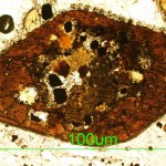
Dacite is a magma type defined by silica (SiO2) content between 63-68 (or 69) weight percent. That is the textbook definition, but some other typical characteristics of dacite lavas (or magmas) is the presence of certain minerals: plagioclase feldspar and hydrous minerals (containing water in their mineral structure)…
Quick news updates for a Wednesday...
The island (and volcano) of Gran Canaria in the Atlantic Ocean. It last erupted in ~20 B.C.
The earthquakes keep coming at Yellowstone - up to a M3.5 in the last 24 hours. Time has already put up an article wondering about whether people need worry about the swarm (there might be other things to worry about before this swarm). YVO's statement on the earthquake swarm seems pretty standard (as it should be): "At this time the Yellowstone Volcano Observatory does not consider the swarm to be unusual and the earthquakes are likely related to tectonic fault…
The weekly volcano report, brought to you by our friends at the Smithsonian Global Volcanism Program and the U.S. Geological Survey.
Highlights (not including Mayon, Nyamuragira and Turrialba):
Eruptions continue at Piton de la Fournaise on Reunion Island - heck, this would be the volcano news if it wasn't for all these other, more explosive systems getting in the way. Lava fountains, flows and pools were the order of the day in the SW Dolomieu crater until the 12th of January.
Chaiten in Chile continues to chug along - block-and-ash flows were seen and ash plumes continue to emanate from…
Some news for today:
Yellowstone National Park, USA.
Another fine example of media headline versus actual research, an article in the Jackson Hole Daily about a new study by Dr. Robert Smith and others on the Yellowstone plume was titled "Park's giant magma plume eating up mountains". Yikes! Well, the actual study published recently in the Journal of Volcanology and Geothermal Research is more about the geophysical parameters of the Yellowstone plume - a plume that might reach as far as 500 km below the caldera itself. As for the mountain eating part, I think they were trying to get at the…
As fall descends on the northern hemisphere, spring starts in the southern. Luckily for us, it means that we get better views of the southern Andes in Chile ... which means the NASA EO could train one of the many "eyes in the sky" (specifically the EO-1) on Chaiten. The volcano is still erupting, going on 16 months, since it caught everyone off guard in May of 2008. As you can tell from the image (linked and below), Chaiten is slowly filling in the pre-2008 caldera with new rhyolite dome growth - you can see that the pre-2008 dome within the caldera (see the picture taken from the ISS in 2003…
Fantastic volcano blogger, and all around cool guy, Erik Klemetti has put out a call for volcano pictures that he can use on his Eruptions blog. I'd love to be able to send him some fantastic shot of a plinian eruption, but I live in a pretty tectonically quiet part of the world.
So this weekend, while Minnow was making spaghetti out of playdough, I decided to craft an offering for Erik:
Of course, as I was feeling all smug about my depiction of a Hawaiian shield volcano, complete with lava entering the ocean and creating hydroclastic fragments, NASA's Earth Observatory posted an image of…
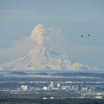
Redoubt in April 2009 with Anchorage in the foreground (along with two F-22 Raptors). Image courtesy of Calvin Hall.
It has been quite some time since I talked about Redoubt, mostly because the volcano has been in the "slow extrusion of a dome" mode that has not generated much beyond impressive steam (with some ash) plumes. The volcano continues to stay at Orange/Watch status. I did glean a few interesting facts and speculations about the future at Redoubt from Dr. Jake Lowenstern of the USGS the other day, including:
The new dome growing on the volcano has more room to expand than the 1989…
UPDATED 3:30PM Pacific: The Associated Press has put up some silent video of the lava flows reaching the ocean at night
The Geophysical Institute in Ecuador is reporting that the eruption at Fernandina in the Galapagos has intensified over the last 24 hours. Heck, the image accompanying the report looks downright apocalyptic:
Now, I'm actually not entirely sure what is being shown in this image. There is no caption, either. My guess is that this is an ocean entry for one of the lava flows, considering the steam and what looks to be water in the foreground. Of course, I have no idea if the…
Fernandina in the Galapagos erupting in April 2009. Image courtesy of NASA.
The latest reports about the ongoing eruption at Fernandina are both coming and going. Reports from officials in the Galapagos National Park suggest that the eruption was become more intense (in spanish), while later reports from the Geophysical Institute in Ecuador say that the eruption is waning. Both reports might be true and reflect the volatile nature of the eruption, but overall it seems that the wildlife (that probably is used to this sort of thing anyway) hasn't been effected too much by the eruption.
Fissure vent eruption from Fernandina in the Galapagos Islands.
In news that comes as a surprise to no one, the current eruption on Fernandina in the Galapagos is having some adverse effect on the wildlife in the Pacific archipelago. Numerous dead fish and sea lions have been seen in the ocean near the actively erupting volcano - now, what exactly is causing the deaths is more speculative. I would imagine with the large plume being produced by the volcano, along with the lava flows reaching the ocean, that volcanic gases and the lava's interaction with the sea water might be the leading…
Fernandina, Ecuador
Fernandina erupting in 2009.
UPDATE 4/13/09 at 12PM: The NASA Earth Observatory has posted a nice MODIS image showing the plume from the Fernandina eruption drifting out over the Pacific.
We have a few more details on the ongoing eruption at Fernandina in the Galapagos Islands. Officials from the Parque Nacional Galápagos (PNG) flew over the island (in spanish) and saw the eruption is coming from a several-kilometer-long fissure vent that flows towards the sea, dividing into multiple flows and then coalescing when it reaches the sea. There is also a lot of vapor being…
Fernandina volcano in the Galapagos.
Fernandina in the Galapagos has entered a new eruptive phase according to the Geophysical Institute (GI) at the National University of Ecuador (in spanish). Satellite images show a new crater and ash column from the volcano and the GI will look for evidence of new lava flows beyond the "hot points" spotted on the satellite images.
UPDATE 4/11/09 9PM: I thought I'd add a link to the story in English now that I found one. There are also some pictures of the lava flows from La Cumbre (There is some confusion about name - Fernandina and La Cumbre are the…

Llaima in Chile, taken on April 9, 2009. Image courtesy of the NASA Earth Observatory.
The NASA Earth Observatory (currently celebrating its 10th year) has posted a number of great images of the current eruption of Llaima in Chile, taken from Earth Observing-1 and Terra Satellites. They show both the ash plume of the eruption and the lava flows associated with it (above). The image here is a false-color image of Llaima, where the bright red/orange is the lava flow from the volcano, along with the dark brown of the ash/rocks from this and previous eruptions.
The eruption itself might continue…
Llaima erupting at night in April 2009.
Brief update for those of you following the somewhat spectacular eruption (above and below) going on at Llaima in Chile. The latest reports indicate the eruption is waning (in spanish) with less ash and explosions (in spanish) being produced. However, ONEMI, the Chilean Emergency Office, continues to keep the area on alert. So far, at least 81 people have been evacuated (in spanish) during the eruptions that gained strength over the weekend and flights between Buenos Aires and Neuquén were suspended due to the ash.
It is interesting to note the…
Today looks to be a doubleheader of volcano news:
Redoubt
Image courtesy of AVO/USGS, taken by Rick Wessels. An infrared image of the north slope of Redoubt showing the hot, new dome material and hot block & ash flows confined to the valley.
At 11:30 AM yesterday, AVO put Redoubt back to Orange/Watch alert status after the volcano seem to settle down to small steam/ash plumes. Less than 12 hours later (at ~6:30 AM Alaska time), the volcano produced another large explosive eruption, sending an ash column up ~50,000 feet / 15 km and producing what seems to be a significant lahar that…
Image courtesy of Calvin Hall. Taken 3/28/2009 during an eruption at 10:59 AM3:28 PM.
UPDATE 4/2/2009 at 11 AM Pacific: I'm moving this up from the comments, but Eruptions reader Doug Cole pointed out (and I have no idea how I missed this) that Redoubt has a new webcam! This one is at the DFR seismic station, ~8 miles / 12 km northeast of the volcano. Great views on it today showing the extent of the ash around Redoubt and the steam/ash plume. This view will also be excellent if we get any dome collapse pyroclastic flows (see below).
After a week of explosions and ash fall, Redoubt seems to…
Goma after the 2002 Eruption of Nyiragongo
The activity at Redoubt has captivated a lot of us, but in the grand scheme of things, its eruption are more likely to caused inconvenience and property damage rather than dramatically loss of life (unless something huge and unexpected occurs). However, the same cannot be said if Nyiragongo and/or Nyamuragira (a.k.a. Nyamulagira) in the Congo were to erupt. These volcanoes are close to the city of Goma, a city of nearly 600,000, not including refugees from the fighting in the region. Eruptions of Nyiragongo in 2002 prompted the displacement of 400,…
Mauna Loa fire fountains in 1984
For those of you looking for some non-Redoubt-related volcano news, you can take a look at the 25th anniversary of the last eruption at Mauna Loa (there is some nice video footage provided by KHNL if you follow the link). By no means is this volcano "dormant", but rather this is a typical lull in activity at the Hawaiian shield volcano. Its neighbor, Kilauea, has been erupting for decades, but the last major eruption at Mauna Loa was in 1984, when the volcano sent lava downslope with 3,000 feet of Hilo, moving 15 miles in a few days. Monitoring at Mauna Loa…
Photos by Dr. Edward Kohut, all rights reserved, used by permission, 2009
Many times people think that volcanic eruptions affect the economy through the destruction inflicted upon the landscape during an eruption: lahars and pyroclastic flows destroying bridges and homes, ash ruining crops and water, lava flows overunning communities. However, in Hawai'i, a new effect of volcanism has been seen in the agriculture of the state. The volcanic fog - or "vog" as its called - has been causing major problems with farms on the Big Island of Hawai'i. Since the new activity at Halemaumau (see above)…
The "eruption watch" continues at Redoubt ... Saturday revealed that things are getting hotter at the summit near the 1989/1990 dome (see picture above that made Redoubt famous in 1989). The overflight of the volcano revealed new holes in the summit glacial and a multitude of muddy streams formed from the meltwater. This area of very intense fumarolic activity is just below the 1989/1990 dome (~7,100 feet) and has been growing over the past few days. They also report an area at ~9,000 feet on the volcano that shows signs of ice collapse, indicating heat from underneath the snow and ice (…