storms
It is now verified that the earliest 2017 tornados -- first tornados of the season -- struck several communities in east-central Minnesota (a few miles north and south of me). So what you say? Especially because it was a mere F1 and didn't hurt anyone!
This is an important event because the earliest recorded tornado of the year in Minnesota was previously March 18th, and that was in 1968. This tornado, striking on March 6th (confirmed yesterday by the NWS) is way earlier than that!
One tornado, near Zimmerman went for nine miles.
A second tornado appears to have passed through the…
I had considered writing an accounting of all the outlandish weather events of 2015, but that project quickly became a tl:dr list of untoward happenings which is both alarming and a bit boring, since it is so long. So, I decided to generate something less comprehensive, focusing more on the context and meaning of the diverse and impressive set of outcomes of anthropogenic global warming, an historically strong El Niño, and, well, weather which is already a pretty whacky thing.
See: Highlights of Climate Change Research in 2015
It should be noted right away that 2015 is the last year in which…
Focusing on Earth, but also a few tidbits on wind, fire, and ice, some current news and observations about global warming.
Earth
As humans release greenhouse gas pollutants (mainly CO2) into the atmosphere, the surface of the Earth, and the top 2000 meters of the ocean, heat up. But some of the CO2 is absorbed into plant tissues and soil, as well as in the ocean or other standing water. Historically, about 30% of the extra CO2 is absorbed into the ocean, and another 30% converted into (mainly) plant tissue. We hope that enough CO2 is absorbed that the effects of greenhouse gas pollution is…
Pam is a tropical cyclone of category 5 strength, but is churning over waters that have high temperatures at depth, a phenomenon we seem to be seeing more often lately, as a result of anthropogenic global warming. That is why I call it "AGW Class." Strong Category 5, deep heat enhanced. It is said that this is one of only 10 Category 5 storms recorded in the basin since good data are available. The Weather Underground has the story.
In addition, there are three other tropical cyclones extant in the Pacific.
Nathan is just on the Tropical Storm-Hurricane boundary and is heading for Cape…
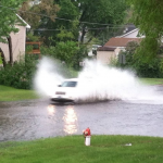
I woke up this morning to find about a dozen reports on my iPad Damage app indicating trees down and hail damage in many communities from Mankato to Edina, south of the Twin Cities. More of the same. We have been having severe weather for about a month now, or a bit less. One day in late May, Julia and I were taking pictures of people driving too fast through the lake that formed in front of our house form a major downpour. Early in that storm we witnessed a ground strike not too far away. A short while after that an ambulance came screaming by our house, coming from the direction of the…
I previously posted a summary of the water-related conclusions from the new National Climate Assessment, recently released after three years of writing, review, and analysis. The following “findings” are a broader summary of the results from the newly released National Climate Assessment (NCA). They are by no means a full summary: far more detail can be found in the chapters and the regional syntheses, but these are noteworthy conclusions. (Note, thanks to Tim Smith – Sustainable Water Resources Coordinator – for highlighting these. The page numbers refer to the NCA Summary)
1. Global climate…

The story of climate change has always been more of worst-case, or at least, worser-case scenarios developing and less about good news showing up out of nowhere and making us unexpectedly happy.
A few decades ago, it became clear that the release of fossil Carbon into the atmosphere primarily as CO2 was going to cause a greenhouse effect (yes, dear reader, we've known this for looooong time ... the idea that this is a recent and still untested idea is a lie you've been fed so many times some of you may have begun to believe it). At that time climate scientists thought, reasonably, that…
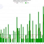
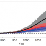
This graph shows the extremes in one-day precipitation in a given month relative to the amount of precip in that month for the Northeastern US. So, if the green bar is at 30%, that means that that 30% of month's precip fell in one event. The way this is computed is a little complicated because it is hard to define an "event" in time and space in relation to the time and space coordinates (as it were) we normally use. Check the source of the graph for a more detailed explanation. The point of this graph is that the opposite is true from what many expect: It isn't the case that the snow was…

"For most of the history of our species we were helpless to understand how nature works. We took every storm, drought, illness and comet personally. We created myths and spirits in an attempt to explain the patterns of nature." -Ann Druyan
Here on Earth, we are well aware of how devastating storms can be. From hurricanes to flash floods, an unpredictable change in weather can turn a serene setting into a catastrophe in no time at all. The clouds that fill the skies can often portend what type of weather is coming, and to me, the most impressive and fearsome of all is the rare and remarkable…
These fragments I have shored against my ruins. - T. S. Eliot
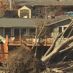
The national news trucks hit my neighborhood last fall, as some of you will remember. When Tropical Storm Irene caused severe flooding and destruction in surrounding communities, and particularly to many of my neighbor's farms, we were briefly in the news. Then, as is normal for any community that has experienced disaster, came waves of volunteerism and assistance, and then a gradual diminishing of attention and interest, and the slow, long process of reclamation and rebuilding. As spring came around, the houses in the village…
This picture, from a current (as of this writing) accuweather forecast page, is an excellent illustration of what happens here in the upper Midwest the spring.
The overall pattern of movement of air masses at the continental scale is west to east, with extra moist and extra warm air secondarily moving north from the Gulf of Mexico, and cool and usually dry air coming form the Northwest (not shown here but note the "blizzard" part) and with dry Pacific/Rocky Mountain air coming from the west. The main energy flow to keep an eye on is that coming from the Gulf.
There is a rule of thumb you…