
San Diego Tribune is reporting the reservation fire has reached South Grade road on Palomar mountain.
Am I correct in thinking this is the switchback road that goes straight up to the observatory? So the fire is 5-10 miles away and below the observatory?
Anyone know observatory status?
PS: apparently fire was mid-mountain about 2 miles from observatory at dawn
PPS: House-to-house battle on top of Palomar Mountain
PPPS: Caltech web site now says wind turned and observatory is safe for now.
UPDATE: definitely a bad fire coming up Palomar Mountain, whether it engulfs(ed) the top depends on what winds did over night, both LA Times and SD Tribune report the firefighters are "making a stand" at the top of the mountain.
UPDATE2 - Dog Yard Observatory has update as of this morning
I am told the MODIS app for Google Earth shows the fire on the west of the mountain but I couldn't get the bloomin' thing to load this morning.
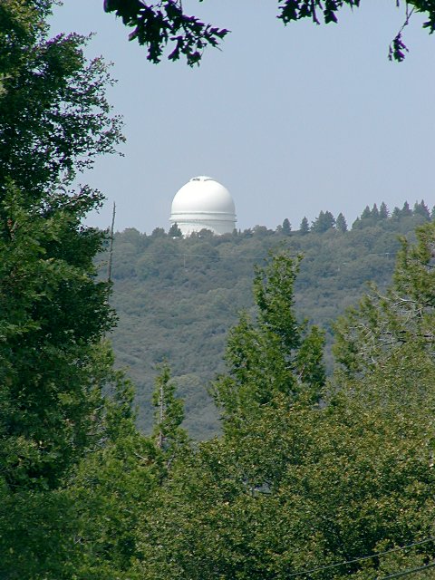
scary perspective shot of dome on top of Palomar - UCI website, view from road
There are refugees evacuated up from the valley there, which is not such a terrific idea, I seem to think there is only one road up to the summit.
Plan I heard from CA is that they'll put the people in the Hale dome... be fun in the dark.
As noted in the comment, the mountain top is quite bare, and presumably they have water and hoses (and pressure...).

Good aerial shot of the Hale dome here - wikimapia - Matt Jones blog

here is a good perspective shot - from some private pilot's web site

The observatory is located in a very open area, surrounded by meadows of bracken fern; I don't think that it will be much at risk from fire damage. In fact, the observatory has been designated as an evacuation "safe site".
As for the rest of Palomar Mountain, I'm heartbroken to say that it's doomed. Unwise fire suppression, severe drought and bark-beetle infestations have primed the forest there for destruction. I have loved that place for many years, but emotionally, I'm steeling myself for the inevitable inferno that will destroy the wonderful forest there.
But the observatory itself will survive.
Given what happened to Stromlo, I am not sure that open fields are a guarentee that nothing bad will happen to the observatory.
Nonetheless, I hope that with the winds dying down, the fire will move much slower and that it will miss the communities around the mountain.
I do know that every observatory in the American southwest has their fingers crossed!
The link for the Palomar fire fighting efforts does not work.
The link is here
You are missing a "-24"
fixed
thanks
South Grade is the road you take to the mountain top; you turn off state hwy 76 from Pala to Pauma Valley. There is another road, East Grade, that goes off to Lake Henshaw, but I think the fire's across that too - there's an alarming picture of giant flames on East Grade on latimes.com. There may be a dirt road that leads to the north. I believe the fire was/is in the valley to the west of Palomar and across hwy 76.
Here's a Google maps link with fire zone shown schematically:
http://maps.google.com/maps/ms?f=q&hl=en&geocode=&time=&date=&ttype=&ie…
The observatory is where it says "Canfield Rd" and the little spur with a loop on the southern end is the road to the 60".
Fire is the greatest fear of all observatory directors (except maybe in the Atacama).