Time to play a little catch up ...
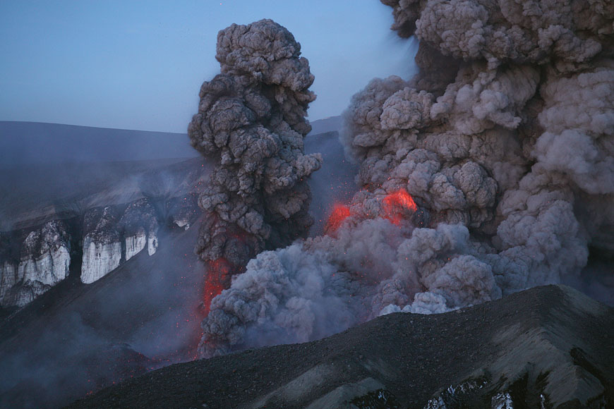
Eyjafjallajökull erupting in early May. Image by and courtesy of Martin Rietze.
- A brief update on our friend Eyjafjallajökull - the eruption plume from the volcano was considerably taller yesterday, reaching 6-9 km (20,000-30,000 feet), but prevailing winds meant the ash hazard was confined to areas in the middle of the North Atlantic and northern parts of the British Isles. However, even as the ash hazard for Europe wanes (for now), you shouldn't forget the amount of ash being dumped on parts of Iceland. If you want to see some stunning images of the eruption, Eruptions reader Martin Rietze sent me a link to his gallery of images and video from a recent summit climb of Eyjafjallajökull. He got some up and close shots of the volcano erupting (see above and the check out the link). You can also check out the daily timelapse of activity at the volcano or another gallery of shots from the volcano.
UPDATE 11:30 AM EDT 5/14/2010: Nice article on Live Science about the ash plume interacting with a front passing through the North Atlantic. - Another Eruptions reader, Manuel, sent me some news about activity in Chile over the last week. ONEMI declared an warning around Villarrica after the SERNAGEOMIN determined that the lava lake at the summit was becoming increasingly active. Tourists are being warned to avoid the popular summit hiking trails. You can check out a bevy of webcams of Chilean volcanoes on the SERNAGEOMIN website.Argentina is also on alert for potential ash from a number of Patagonian eruptions that may be in its future.
- One other volcano that is almost always in some state of unrest, Popocatepetl, also has a webcam you can watch. Over the last few years, the volcano has had an almost constant steam plume with minor ash - and remember, Mexico City sits in the shadow of this volcano.
- And if you're been concerned that we haven't seen many volcano-related movies lately, your wait will be over soon ... sort of. Syfy announced they have started shooting a movie called "Super Eruption", where (you guessed it) Yellowstone erupts. It is, of course, being shot in Bulgaria and if it is run by the same types who decided "Syfy" was a good name of a TV network, we know its going to be great. (And as a sidenote, can't we have a different large caldera system erupt in a movie?)
- And remember, the thirtieth anniversary of the eruption of Mt. Saint Helens is next week, so send me your memories. You can find a lot of articles commemorating the eruption already.
Good morning
Photos from my trip out there, mostly from Tuesday but the last three are from yesterday (Thursday). I had to work on Solheimajokull glacier on Tuesday afternoon, which at the time was right in the heavy tephra fall area. Not a huge amount of fun. I was as that glacier maybe a month ago and it was beautiful and white, but now it looks like the Moon out there!
There's an interesting shot of the tephra fall that I took near Thorvaldseyri, too (near the THEY GPS station). It's amazing how much stuff has fallen! There's a very visible thick, dark layer representing the first phreatomagmatic-Plinian phase, and then alternating bands of lighter-coloured tephra above it from more recent phases. Pretty interesting stuff. There were some hard layers part-way down from rainfall mixing with the tephra, but the stuff on the surface was loose.
Here's the Flickr album:
www.flickr.com/photos/10738332@N00/sets/72157623934563325/detail/
Click the photos for a bigger version.
I took some video footage which I'll try to upload soon, too. My internet connection is being funny though...
James: Interesting photos. One question: Do you think the glacier is now better insulated under several cm of Tephra or will it heat up, since the surface is now black.
While things are quiet on the blog - could someone tell me if "Plinian" comes from the Vesuvius eruption in 79AD watched by Pliny the Younger and in which the real scientist of the family, his Uncle, Pliny the Elder died. I have sort of presumed this but would be grateful if someone would confirm it.
#2, James.
Wow, very nice pictures. It can't be easy to work under those conditions. Looking forwards to the video.
Thanks!
@Chris:
A thin covering of ash will increase the surface albedo and increase melting, but once it hits a certain threshold, the tephra begins to insulate and will slow down melting. This explains the formation of dirt cones and ogives (possibly) on glaciers, amongst other things (well, dirt in general, not just volcanic products).
I didn't get onto the glacier surface itself, but certainly if there's as much ash and tephra on the ice surface as on the ground below, I'd imagine it'd be pretty nicely insulated.
--------------------
@mattlee:
That's how I understand it, yes.
Thank you James. For that and all your contributions.
@ Chris: Glaciers get covered with rocks all the time - mainly from debris flows onto the top of the glacier. The glacier do just fine with that debris on top, so the tephra likely doesn't have a huge effect on melting the glacier. Check out one debris-covered glacier in Antarctica here:
http://www.livescience.com/php/multimedia/imagedisplay/img_display.php?…
@Anna, Reynir - old thread 'kolniður' trans. - thanks
@8 ... Erik ... I have seen icebergs off Newfoundland with black lines running through them ... am I correct in assuming that this is ash?
@Matlee, #4: I think so, yes. It also one of the oldest detailed reports of an eruption which is still available today.
@James/Erik: Thanks for the explanation. I remember some cold war plan from the 60s which involved covering the arctis with small carbon particle to melt the ice and flood the harbours of the enemy by this way.
http://oiswww.eumetsat.org/IPPS/html/MSG/RGB/DUST/WESTERNEUROPE/index.h…
Ash cloud looks like it's right over northern UK, but no planes grounded (except BA strike) LOL!!!
@mattlee (#4) that is correct, Plinian indeed is derived from the two Plinys that played an important role during the AD 79 Vesuvius eruption; that eruption was indeed a type example for what we call today a "Plinian" eruption.
The current Eyjafjallajökull definitely is NOT a Plinian eruption, and at no time has been such; the initial phase of the summit eruption was "Surtseyan" (phreatomagmatic) and then it became Strombolian-Vulcanian.
From what can be seen from the Hvolsvöllur webcam (eldgos.mila.is/eyjafjallajokull-fra-hvolsvelli/) today, the activity is quite strong, and there seems to have been little wind allowing the plume to rise higher than for a while.
#9: Anyway, I did a bit of poking into where the word 'kolniður' might come from. The lyrics to 'Kolniður' look rather dark and dingy to me. My best guess is that it's derived from 'kolnið' (coal-black 'nið'). 'Nið' is the waning phase of the moon, so 'kolnið' would, to my guess anyway, be the end of the waning, when the moon reflects little or no light to the Earth.
Should it interest anyone, the current picture (14:00 UT) from the camera in Surtsey shows a dark western sky.
Heavy ashfall in Vestmannaeyjar.
@16 You can see it on the radar.
http://en.vedur.is/weather/observations/radar/
interesting blocky islands out there too, from Surtsey - other eroded little underwater eruptions?? can't believe I flew over S. when it was first emerging, Dk to Is...
More music inspired by Eyjafjallajökull:
http://www.myspace.com/elizanewman
I can't link directly to the song. You'll have to wait for the flash player to load, and start playing the song Eyjafjallajökull.(Some of you will probably remember the beginning of the song from Al Jazeera News where she was teaching people how to pronounce the name of the volcano.)
I've kind of fallen in love with this song. :D
At last, the Vestmannaeyjar webcam is useful to the volcano nuts. (Turn off the focusing aid if a box is showing.)
82.148.72.2:60000/control/userimage.html
For anyone new: click on my name below to see a map showing Eyjafjöll and neighboring webcams.
If you have an hour or two to kill, check out the Martin Rietze site mentioned in section one of the update.
The video clips have audio!
# 20, PeakTV: that is a supermap, thank you!
That has been a lot of work, to put all that information.
I blame all the volcanologists who don't spend anytime promoting Long Valley, now that would be exciting. I guess all the rough terrain around it, especially the White Mountains, makes calculating the destruction would be difficult, but that never stopped the History Channel before.
@23 Don't you mean the Armageddon or Future History channel? ;>)
Oh, @Erik's fellow scienceblogger has a gem here:
http://scienceblogs.com/principles/2010/05/bohemian_mechanics.php
looks on Hvol cam as though it's getting a little more explosive again up there - 'burps' of plume rather than continuous..just viewing angle?
@25 Reynir That was absolutely hilarious, and I did read the more obscure jokes first, which helped. Next step is to get a group of scientists to do a video. Would go viral. ROFLMAO
Ash + children = playtime!
http://www.mbl.is/mm/frettir/innlent/2010/05/14/skrifad_i_oskuna/
Video clip is Flash, IIRC.
Darker clouds/ash/smoke? passing by on the Thoro cam
@Boris, 13:
I thought they sort of created a new definition for the early phase of this eruption, and it was dubbed something like 'Phreatomagmatic-Plinian' because it had features of both. Not saying it was anything approaching a full-on Plinian eruption at any point, but I do vaguely remember that definition cropping up (in one of Erik's posts, I think).
Would be cool if Brian may and co. were to re-record the song with these lyrics.
Closer to topic: "We invited a group of 33 women from the farms under Eyjafjöll to Vestmannaeyjar to give them a bit of rest from the ash -- and this happens!" Comment on the ashfall today in VEY.
What is that on the ground in front of the volcano to the far left on the Thoro cam? Flir is showing at it as fairly hot. Thanks
Lot less fog around Ãórólfsfell. You can see the plume on its SSW drift.
@reynir 25 gem indeed...
A few threads back we were commenting on the white flashes that occasionally appear (not lightning). One of the Rietze videos shows this happening. I can't see a time stamp, but it's approx 1/4 into the video.
www.mrietze.com/images/Iceland10-2/MVI_6187.MP4
It seems that the loud explosive sound and pressure blast that hits the videographer shortly afterwards could be a result. Is this a magnesium flash?
@Corporal_E 32 . FLIR playing games again, I think - there's solar radiant heat to the dark ground, regardless of passing clouds (you can get sunburn w/o clear sky principle) - FLIR is always hungry for heat from any source. No vegetation to speak of yet to dull the heat reflection. My guess.
@36 Thanks...I have just not seen the regular Thoro cam with those colors at the same time as the FLIR showing such hot spots
OK arch fans - have we had tecnical collapse? on voda closeup, looks like there's a chunk that has fallen into the cleft...it's been there a little while, this is the first time I've looked at it up close...
@37 notice that the moraine hot spots are the ones with no or least green..screen catch the cams sometime and compare.
@39 Gotcha. Still wish I had a FLIR :)
@38
I think that this chunk appeared on the 12th. It was not there on the 11th. The 12th was a very foggy day, but you can see it on vodafone cam around 12:00. I'm not sure, but I think it was not in the cleft before the fog, around 4:00 (look at 4:30, just before the fog hides everything).
@ Carla 35: I've watched that video closely and the fleeting white cloud seems to me to coincide with an exceptionally vigorous blast; I think the ejecta went momentarily supersonic, which would explain the cloud, the shockwave, and the bang!
This video shows the same phenomenon beautifully:
http://www.youtube.com/watch?v=8aPygh_C_ro
@2 James, great shots... and i'm glad to see the masks. i actually have a couple of those masks around.(hanging from the hooks by the door, in the car, in my purse.) Best to be prepared. And You need more than one for sharing. i've learned the masks sell out pretty quick in the local stores. Did Your eyes sting? i noticed no eye wear. Thanks for sharing.
Best!motsfo
Boris @13 & Chris @11 Thanks. Having read about the Plinys' descriptions of the 79AD eruption, I can see why you all keep telling us that this is nothing like it - at the moment:)
Thanks to Erik for the link to Martin Rietze's gallery of photographs and especially the video. The footage is incredibly high quality i could watch it over and over. I would love to have been there as long as i had my cloak of invincibility with me :) It's amazing to think that Eyjafjallajökull has been erupting like that and more powerfully for around a month.
@ Carla the white cloud you see is the change in atmospheric pressure from the shockwave of the supersonic material being ejected, quite a bang !
FLIR TimeLapse 2010-05-13
http://www.youtube.com/watch?v=o9ZPEKRZ6Bs
Thanks Tintin for the FLIR timelapse!
If you haven't seen it, there's a sterling photo of the glacier from the air on yesterday's IMO page (added later in the day) that puts the Thoro/voda cams into perspective.
http://en.vedur.is/earthquakes-and-volcanism/articles/nr/1884
@fireman, @zander: thanks for the supersonic explanation for the white flashes we have been seeing. So glad there is sound in that Rietze video. It's astonishing to see and (a few heartbeats later) to hear. This is how I imagined Eyja sounds and looks up close, all these long hours of staring at the Mila cams.
Also, @fireman, that youtube video is amazing!
Crevace along the glacier formed by the lava rather distinct now with the clear conditions. The snow on either side really makes it stand out.
Wonder if the coming week will be the week for the lava to make its appearance. Looks like it's at the drop off point.
Nice chunk of ice stuck in the big crack. Looks like a big hole just above it.
@carla #35 (and cc @fireman #42, @zander #45) Thanks for posting that video of the white flashes.
I have downloaded it and taken screen shots of the frames that include the white flash. You can see them all here:
http://skitch.com/suwc/
Seeing it frame by frame, it looks very much like fog, so I presume that the shockwave mentioned by Zander causes instant condensation of moisture, which then immediately evaporates again?
New status report:
http://en.vedur.is/media/jar/Eyjafjallajokull_status_2010-05-14_IES_IMO…
Small quake at Mt. Hood, OR.
2.6 2010/05/14 19:03:04 45.362 -121.753 5.6 MOUNT HOOD AREA, OREGON
@ 54 Brian.
It was interesting going through the chronology of MSH today and seeing the same, "she's about to blow, no she's not", tooing and froing leading up to the eruption that we experienced here (and at Redoubt last year). What surprised me was that seismic activity at MSH appeared to be way more pronounced than here at MSH with a large number of >M4 quakes right under the volcano and still there was a lot of disbelief among many of the local population that anything dramatic might happen.
Neat site here. You can zoom way in on earthquakes in the Cascades.
http://www.pnsn.org/req2/
2 small quakes on Tues at Mt. Hood, and 4 today. Hmmm!
Hi Brian!
Long time lurker here from Oregon City.
Thank you for bringing the action at Mt Hood to my attention.
Very interesting.
@Suw: interesting to see the still frames showing the supersonic flash. I found a bit more about this "Prandt Glauert singularity" here:
en.wikipedia.org/wiki/Prandtl%E2%80%93Glauert_singularity
Also, Scarlet P. and Erik K. should get the thanks for posting links to Martin Rietze's amazing videos.
@ Brian D, the CVO don't seem to concerned by these earthquakes. http://volcano.wr.usgs.gov/cvo/current_updates.php
#2: Neat images, indeed. My sister said she got several good shots from Route 1 two days ago, but I'll have to wait until her out-of-country trip is over.
I texted her about the air closures today, and she just stuck out her tongue at me! Ick.
Looking at the webcams right now, either there are really strong low level winds pushing the plume to the west, or she's erupting from a different part of the vent. If you look at the Thorolfsfell webcam you wouldn't even think there was an eruption, but if you look at Hvolsvell, the plume is huge.
#42: Really cool video. Only one tiny teeny-weeny little problem: It distracted me into watching Gloster Javelin videos. The horror, the horror...! :-)
Here is a good web site where you can follow seismic activity (or lack thereof) at all the cascade volcanoes.
http://www.pnsn.org/WEBICORDER/VOLC/welcome.html Each seismograph opens up in a new window (or tab, if you choose that option).
As far as Mt. Hood, the statement that Zander refers to is this: "Recent Observations: A minor swarm of about two dozen earthquakes that began around March 21 has continued this week. The largest earthquake, a magnitude 2.4, occurred at 10:09 PDT this morning. These events are not thought to be of volcanic origin. Mount Hood produces small swarms of this size once every few years."
I seem to remember that there was another EQ swarm at Mt. Hood shortly after the 1980 eruption of St. Helens, which of course did not lead to any activity.
@motsfo:
I only jumped out for that shot very quickly, so I just kept my mask on and didn't bother with eyewear. Yeah, my eyes stung a little. You get tephra in them whatever you do (much the same with ANY little exposed crevice on your body).
When working on the glacier I was wearing goggles the whole time (and something more substantial than a hooded sweatshirt, too!). You really have to.
Holy cr@p... the plume on Hvolsvelli is beyond impressive...
This... is plinian activity, my friends... straight up to the upper troposphere.
Here is link to Pliny the younger's description of Vesuvius.
http://www.volcanolive.com/pliny.html
Guesstimation of plume height based on the mountains.. at least 15 km (45 000 ft). That may be it..
We may be seeing the magma which caused the earthquake swarms of the last days reaching the surface. This is deep, gas rich, fresh magma.... ideal candidate for some explosive action...
"The cloud was rising from a mountain-at such a distance we couldn't tell which, but afterwards learned that it was Vesuvius. I can best describe its shape by likening it to a pine tree"
Kudos for Pliny the Younger....... perfect description...
@ volcanophile,
certainly looks pretty impressive but I'd throw my money on this still being sub-plinian. It's not standing up to the breeze. By that I mean there is no sustained vertical eruption column to a high altitude (the trunk of Pliny's tree if you want to put it that way).
I think it only looks higher and more voluminous to us because it is not getting whisked away by the typically strong winds. That said, there is still a good volume of ash getting generated here. I wonder how long this will go on?
@Volcanophile (#68) - 15 km seems rather too high an estimate for me, that would be considerably more than during the most violent phase of the eruption on 14 April ... the Icelandic news would report that (but they don't). Consider that the volcano itself is a mere 1660 m tall, and we don't even see the whole height of it in the Hvolsvöllur image. The top of the image field is maximum at 5-6 km elevation. The report by IMO states a height of about 7 km throughout today, which seems more plausible. It is easy to overestimate the dimensions of volcanic ejections especially once they are out of the field of visibility (which precludes any possibility of estimating the height because we don't see the top of the eruption column); I've done that myself during my early days on Etna, much to my own embarrassment.
Yep.. no perspective, no reliable guesstimation ;)
@Bruce.. at Heklubygdd (sp) the wind is 8,0 m/s... that is about 30 kmph... and still, that thing is shooting ash straight up against it... really violent...
A good, strong, massive subplinian ...
Latest newsreel on RUV has quite impressive footage of today's ash plume and its impact:
dagskra.ruv.is/sjonvarpid/4497992/2010/05/14/2/
Certainly the activity is strong today - from the look of it the ash is quite black (thus, rather basaltic or basaltic andesite, not highly evolved), but as Bruce noted there is not a sustained Plinian column, it continues to be a relatively weak eruption plume, which is bent by the wind.
@Boris.. thanks for the link....
really strange.. This volcano does very unusual things....
How is it possible that:
1:) with a very silicic andesite (61,5% SiO2 that's quite something) we still get lava flows and lava spattering Strombolian-style.
2:) now the magma composition may have turned back to basaltic, and it's even more explosive...
This volcano is doing exactly the contrary of what we could expect it to do.....
@ Volcanophile,
I agree, good, strong massive subplinian!!
This is not to dispute the power of the blasts.. the footage from Martin Rietze is absolutely fantastic evidence of that, particularly the one with the sonic shock wave in it.
From Martin's videos it looks like the cone surrounding the vent is now almost as high as the ice cap which was put at around 200m. Is this a good guesstimate?
Based on the footage of M.Rietze, it's really impressive to say the least, all of this for a mere (guesstimated ;) VEI 3+...
I can't even think of what something like Tambora or Krakatoa (VEI 6+) might have looked like at close quarters... (anyway, that would have been the last thing I would have ever seen before being incinerated by pyroclastic flows...)
Speaking of pyroclastic flows.... is Eyjaf capable of doing this... On a glacier, this could be devastating (does anyone think of Nevado da Ruiz in Colombia, which did just that.... pyroclastic flows over a glacier... obliterated Armero, 24000 deaths...)
Cn anyone tell me how normal the ongoing earthquake activity across Iceland is? The amount of quakes near Grimsey and to the south near Reykjavik is this 'normal' background activity?
Perhaps some of the Icelandic contributors could help. Thanks
What I see now is not as strong as it was around 8:30 EST in the US. (not sure GMT) Then the plume for about 20 min went straight up off the screen. This however is thicker and darker.
Still quite a POP.
@78 that would be 8:30 AM May 14
@27 temp i think if it is significantly hotter than a "normal" andesite eruption it would be rather fluid until it cooled to the 900 C closer to the normal for that type of lava
i could be all wet, and wait for a better educated person to chime in
Boris, could you or Erik maybe do a short explanation for all of us explaining the interaction of 1) magma type and 2) gas in solution to explain the remarkable range of eruptive styles we have seen here?
I for one am still a little confused about it and for this reason: the primitive magmas at Fimmvorduhals were low in gas. They were also hot, runny basalts leading to a good Hawaiian style eruption. Nothing strange there.
The crater eruption on the other hand is andesite which means basically the magmas are stickier and generally cooler. Now this does not automatically translate into explosivity: witness Chaiten which is still chugging along after two years squeezing out a rhyolitic dome. In other words, the explosivity comes primarily from the volatiles in the magma, which I believe are primarily H2O and CO2, and not the Si concentration of the magma, which merely encourages greater explosiveness IF gas is present (stickier bubbles burst with greater force). So far so good.
Now, why do the more evolved magmas here at Eyjafjallajökull contain more gas than the primitive magmas erupted at Fimmvorduhals if these Si-rich magmas have actually evolved from the primitive basalts anyway? Is this a side product of crystal fractionation or they in some saturated from ground water after spending so many years in quiescience at a shallow level?
Or is the gas concentration actually comparable to Fimmvorduhals and the explosiveness we are seeing is due solely to the higher concentration of silica?
@Bruce.. Indeed.
When Etna had its big series of paroxysms in 2000, it erupted runny, but extraordinarily gas rich basalt. Thus the eruptions were very violent, jetting lava and ash several kilometres high, what you and I would call a "solid massive subplinian eruption".... not what you could expect of a typical basaltic eruption.
On the other hand, Chaiten, which is erupting rhyolite (something super-extra-sticky, way more so than andesite or dacite) is doing this rather peacefully, whithout even any pyroclmastic flow from dome collapses... again not what you could expect...
I've learnt that Etna once had a "basaltic plinian" eruption, that is, the gas contents were so massive, it didn't matter if the lava was sticky or runny, it just blew up.
On the other hand,
hat would also explain what Vesuvius did in 79... this volcano isn't known for emitting viscous lava, there has never been any dome growth episode there at least in historical times (the first time dome growth was described was at Montagne Pelée in 1902, if such a thing had happened at Vesuvius before it would have been known long before...)
That's like opening a bottle of shaken diet-coke... you get half of it spraying everywhere...whatever the viscosity of the contents may be..
@#76 Just look to footage of Pinatubo if you want to see upclose plinian (well, ultra-plinian) action. I stumbled across this video the other day when looking for pictures of it on youtube. I believe it is called "Escape from a Killer Volcano" and shows the evacuation of Clark AFB in the Philippines. Those scientists really nailed that call. Saved many lives. There isn't as much footage of the plume as I would like, but I can't really blame them for not sticking around. It is terrifying and awe-inspiring to watch just on video all these years later. Even scientists who have waited all of their professional careers to see something like this eventually want nothing more than to get away from this beast.
It is about half-hour in length and is split into 3 parts. The first part seems to have started late into the show, so don't be alarmed, I couldn't manage to find the very beginning.
Part 1: http://www.youtube.com/watch?v=SMe0VPQftsc
Part 2: http://www.youtube.com/watch?v=PvpBbiCG-7s
Part 3: http://www.youtube.com/watch?v=74QkHh45bjw
I'm sure some of you have seen it before but it puts the current eruption into perspective for some of the newer cam-junkies like myself :)
Oh and thanks to our host and all the people providing analysis in these threads! I've found a new blog to enjoy.
Greg
Preceived ash height and color have a LOT to do with which
way the wind is blowing(even a small variation toward You will make the height seem much taller) and even high clouds will darken ash considerably. Moisture will make it look black. i remember getting the shock of my life after one of Redoubt's eruptions. We went from winter white to coalmine black in a matter of minutes.
And Good for You, @65 James! i'm glad to hear about the protective eyeware. (now i don't have to call Your Mom ;) )
Best!motsfo
@KarlUK 77 Not exceptional I'd say (been using IMO's EQ map as home page for ten years.)
But you can form your own opinion from these pages:
Monthly map since 1995:
http://hraun.vedur.is/ja/viku/2009/
List of every EQ since 1990:
http://hraun.vedur.is/ja/viku/svenni_listi
http://www.youtube.com/watch?v=3ydnLkVvfZM&feature=player_embedded#!
BOOOOOOOOOOOOOMM!!!
The FLIR cam looks like quite a show.
http://eldgos.mila.is/eyjafjallajokull-fra-thorolfsfelli/
@Scarlet Pumpernickel Awesome video. All the sensations of being there without losing an eye :)
Mount Hood is stirring in its sleep:
http://www.pnsn.org/HOOD/hoodrec_eqs.html
and
http://www.pnsn.org/HOOD/hoodfigs.html
#86: Definitely a video to drool over.
#86 Amazing video! I wonder how these people have the guts to come so close. We can only be too grateful and enjoy the show.
#68 #84 I agree that the plume is higher, but looks more impressive because of change in wind direction. Just compare its current apparent height on Múlakot cam and the way it bends differently from what it showed in the previous days (towards the watcher).
@86 - Well....there WAS a time when á¿ thought my screen captures were pretty exciting..... ;)
Having a longer runnning time is great. Sound ditto. Reminds me of waiting for the next big wave in Hurricane season....thanks.
Wow, who lit the dynamite on "E". With an average plume height of 27,000 feet, plus a beautiful steam and ash plume. My heart goes out to the people in Iceland, who have to deal with the heavy ash falls.
@ 86, Wow, speechless.
Interesting little sequence of EQs.
@Boris 73 - : ( wonder if there is another link to this - even with VLC my mac won't play it...I get a sub-window before I have time to click on the 'play' arrow....
Interesting conversation re: type of eruption...
Good evning. I see I checked the volcano status at the right moment. Hekla seismometer shows a interesting signal http://www.simnet.is/jonfr500/earthquake/tremoren.htm
@ Brian #95: Meanwhile 8 EQs.
8 EQ's in an hour and a half. I think I'd avoid that side of the valley.
9 EQ. one deep
Make that 10 EQs
10 EQs, most shallow.
WTF. Why are the EQ:S making a line perpendicular to Eyja?
What is that light bottom left on the Thoro cam?
FLIR cam is high in activity too
Is it harmonic tremor or wind noise in the hekla seismograph? The tremor plots are showing no change. http://hraun.vedur.is/ja/Katla2009/stodvaplott.html#googtrans/auto/en
This is a odd sequance of earthquakes. They might be related to tension changes in the area. But they are in the Tindafjallajökull volcano system, that is north of Eyjafjallajökull. Given the current location. But what is intresting is the fact they are all located in a small place. This might be a dike on the move there, I at least won't rule that out.
I don't see a lot on my geophone due to wind noise (8m/s and above).
The eruption appears to have gained strenght following this swarm of earthquakes. That is also intresting.
2 more EQs at depth
Another 2 EQ 22,0 and 22,01 deep
WOW! Look at FLIR! http://eldgos.mila.is/eyjafjallajokull-fra-thorolfsfelli/
And lava again just now http://eldgos.mila.is/eyjafjallajokull-fra-thorolfsfelli/
@86 one word, Amazing!!
Not one, two deep, 10 total. Reloading magma. Interesting axis pattern.
Speaking of tremor graphs, we need Peter and Mr Moho to take a look at the embedded periodicity of the vertical tremor plots. The pattern is rather regular.
The EQ's are very interesting. They follow the rifting pattern of the mid Atlantic ridge. If I were a Volcanologist I would say letâs see what happensâ¦. But I am not and as such have no professional reputation in the field to worry about ⦠soooo I say we are witnessing the first stages of a massive fissure event of global climate changing proportions(Like Laki) and we all better start buying canned food while it is cheap.... Or maybe not .
In all seriousness it does seem to show some possible new magma movement and we may get quite a show in a day or 2. If the quakes get stronger (4-6âs)then re-read above hysterical rant.The northern grouping of quakes I find interesting.
Another deep EQ and lightning is back!
@Jame #6.
Tephra is a crappy insulator. Bogus logic. Black body absorption /albedo change is one of core thermal processes underlying polar temperature rise.
14 EQs and I have to go to bed! Grrr.
15 now
Trying a video capture software, CaptureWizPro, and it seems to be pretty good (easy). One minute came out to about 1 meg. You can see it here, FLIR from few minutes ago.
http://www.flickr.com/photos/8388935@N04/4607921816/
Is the northern group of quakes near the hypothesized crypto-dome?
Looks like the quakes have been adjusted, depths and locations have changed now.
OMG! who the hell is that crazy mother lover in the orange jacket????
I sure hope that hard hat hes wearing aint made of plastic!
21 EQ's now. The last batch is not deep. http://en.vedur.is/earthquakes-and-volcanism/earthquakes/myrdalsjokull/…
Fantastic lightening on Ãórólfsfelli!!!!!
@Renato YES!! quite some activity!
As they say in Seattle, "the mountain is out". The Olympics to the west are crisply outlined under snowy hats and a bulging Mt Rainier dominates the southeastern horizon. In towns along Rainier's western slopes, a lahar warning system was tested a second time this week after the first test failed due to a corrupt audio file.
Although we live in an active volcano region, most people I know seldom think about it. This is even true for people who were here for the Mount St Helens eruption, a distant childhood memory for my younger friends. (I lived in oblivion on the east coast.) In the summertime when Rainier is visible for days and weeks in a row, I can even forget what she represents. But after these days of watching Ejya, Rainier looks ripe and ominous, and I watch with renewed awe and respect.
@126 Carla You're right, it's spectacular when the ' mts. are out.' Rainier from down by Olympia is even more impressive.
Oi, Roberto, where are you keeping the lighting? I have been watching off and on and have missed it, I guess -
Tudo bem, over & out for the night.
I feel bad to say it, but, as long as this eruption doesn't pose any further harm to Icelandic people, I don't regret some more earthquakes to keep it going. I don't think my poor English knowledge could express my feelings any better then what's been already said about Eyjaf, the humbleness and awe it inspires with her beauty! Lava + ash plume + bombs +lightening . If it isn't Thor or Zeus himself,then, what else?
@Erik: "And as a sidenote, can't we have a different large caldera system erupt in a movie?)"
The film is actually about the Bay of Naples caldera going up, but the americans turned up and grabbed all the credit :-D
http://en.wikipedia.org/wiki/U-571_(film)
@127 @byrdseyeUSA: Tudo lindo! I was just staring at the plume on Thórosföllur cam, and saw this huge, but huge, lighting all over the bubbles on the plume. Couldn't believe my eyes, until it happened again and again, and I could also pick one on Hvolsvöllur as well, but fainter. Breathtaking!
@birdseyeUSA - yes, Rainier looks HUGE from the viewpoints near Olympia. Can you see it from your computer? If so, I'm jealous! I have to go outside to see it. The view behind me as I sit here is to the west-northwest.
@Passerby, 116:
Then how else do you explain the formation of dirt cones on glaciers, for example?
They're prevalent on Icelandic glaciers. The process involves tephra falling on glaciers. Where there is a depression in the ice surface, the tephra builds up a little thicker. The thin cover on the ice surface increases surface albedo and promotes melting, and the tephra disappears, but where it is thicker it has an insulating effect. Thus the ice does not melt in these areas, leaving cones which are still covered in thicker tephra cover. You basically get inverse topography on a small scale.
The reason I was out that way this past week was to help with a study of Icelandic glaciers so this stuff is pretty fresh in my mind.
Plume is wide, dark, and vertical... Could anyone post a link to the radar where I can see the height?
I am so excited, I just saw lighting on the Poro cam! Wow! This is an omen, as I have quit my PHN job and am returning to the Airplane (flight nursing) full time! I can watch Volanocam all day now!
Now intense ashfall on Ãórólfsfelli, to the right of the plume.And new earthquakes to the north of Ejyaf glacier?
Black ash rain in Hvolsvöllur. Just found this video on youtube. I can't imagine having black rain! This must be horrible for the locals dealing with this.
http://www.youtube.com/watch?v=bYfOiqILhgs
I just saw some lightening on the Poro cam. Wow! This is a good omen for my life change: no more PHN, flight nursing full time. I can now view Volcanocam full-time. I think that the endless fascination with this eruption, is, we can view it in real time, check in for lava, watch for a while and then go on about your day...Thank-you Dr. Klemetti, and the rest of the eruptions crew, you have brought Earth Science into our everyday life.
Hello!
Check also the latest Llaima reports. They suggest something is cooking inside there. And there is new info about quake swarms beneath Chaitén in 2005 (and surrounding volcanoes)
Erik, what happened to the MVP? Lot of time without one.
No updates on tremors?
They seem to be repositioning quakes under Eyjfa
http://en.vedur.is/earthquakes-and-volcanism/earthquakes/myrdalsjokull/…
What happened to RÃV's cams (Katla and Hekla)?
StarBP @ 131: Here's the radar link. Note that the plume has to have a certain density before it is picked up by the radar, so the top might be higher than the radar indicates. brunnur.vedur.is/radar/rb5/eht.html
Renato @ 141: The RÃV cams have been out for a while.
For speakers of American, Ãórólfsfelli transliterates to Thorolfsfell in English.
The tephra doesn't melt; if it 'disappears' from sight, it is either windblown (aeolian redeposition) or covered in fresh snow in place. As in the case of fine sands or loess soil particles, cones that form are caused by an underlying change in surface topology that serves to catch and retain additional seasonal frozen precipitation or are scour anomalies.
The effect we are speaking of (fine ash induced albedo shift, heating) is a large scale surface effect.
Several natural and anthropogenic sources contribute to 'dirty' high altitude glaciers: volcanic ash, dust storms, biomass burning and black carbon from coal/oil combustion.
In warmer winters in Iceland, the rate of snow deposition is so low that the glaciers are quite gray when checked by volunteers on annual glacier recession outings (as noted in on-line discussion reports of these groups).
The historic deposition rate can be substantial, as is the case when coal was the predominate combustion fuel source in the pre-petroleum oil era (before the 1930s-40s), pre-air pollution control (1970s) in North America and Europe or Asia (late 1990s) or during peak biomass burning events (Indonesia/SE Asia 1998), as measured and reported in polar and high glacier ice core studies.
@Peak VT: Thank you. I've been watching the eruption from Hekla's cam. My eyes are eager to see more and more... Do you believe, since the quakes are trending to the north, that a new fissure could be opening towards Tindfjallajökull?
Curiosities on Ãórólfsfell
Ãórólfsfell is a tuya, and is the location of the MÃla Ãórólfsfell webcam. (The cameras look south and are located ~9.5km/5.9mi from the caldera center at ~530m. The lower camera is a thermal imaging device. Right-click to adjust stretching in the upper camera. The name is spelled "Thorolfsfell" in the English alphabet.)
source : "http://maps.google.com/maps/ms?ie=UTF8&hl=en&msa=0&msid=101672425956645…"
"A tuya is a type of distinctive, flat-topped, steep-sided volcano formed when lava erupts through a thick glacier or ice sheet. They are somewhat rare worldwide, being confined to regions which were formerly covered by continental ice sheets and also had active volcanism during the same time period." (Wikipedia)
#145 The source above was provided by @ PeakTV, thank you for the useful information!
@Passerby #143 http://i40.tinypic.com/2yzhq41.jpg
I think the white stuff shown in the link from the Hvolsvöllur webcam is snow caused by the large amount of condensing water vapor.
If snow readily accumulates as quickly as the webcam pictures indicate then the size of glaciers is strongly contingent on the amount of precipitation received and the growth that it creates.
Another EQ about 17km deep
Sorry: Peak VT
Renato @ 144: Since the earthquakes are so neatly aligned, it would seem something related to either a fault or a dike/fissure is happening. But the existing surface fissures on Eyjafjöll that I've seen mapped run roughly east-west. And according to pdf below, the NNW-SSE pattern of earthquakes has been going on for a while without producing a surface feature. My guess is that a new fissure will open... hundreds of years after we're dead. :| But your guess is as good as mine.
hraun.vedur.is/ja/skyrslur/Jokull51skj2000.pdf
The way the column goes down on Hvolsvöllur cam does not look good.
@147 Late seasonal snow, will probably melt off soon (this summer). The glacier mass balance is far in the red, when present mass is compared against 1992 study results, with recession (outlet glaciers) and thinning due to high latitude polar warming (longterm trend) and less-than-typical winter deposition (shorter term trend). The outlet glacier recession at Eyjaf is the highest for any Icelandic glacier, despite it's altitude, as it's a southern coastal icemass.
PeakTV is kinda funny. Will there be a peak, or is the supply of TV programming inexhaustible...
#150 @Peak VT: I don't think I'm waiting for this to happen. We'll be getting enough of this beauty for a while, so I hope, but afterwards I may retire before that fissure shows up. But there was a discussion on that matter earlier on this thread. Seriously. Rupture of North Atlantic Ridge, a new Laki event, global cooling, you know, those things that can be quite scary. This volcano has already given enough surprises and I'm plenty satisfied. I watched through the whole Fimmvorduhals event, and now this phase. It's wonderful and I am honored to witness the whole thing. Well, I think is time to bed. Thanks again.
More earthquakes to the north!
I don't think that is snow....Looks like the wind is blowing the ash back more toward Hvolsvelli.
#86 amazing video!
Thanks @all for posting timelapsvideo's, screenshots etc. It helps cathing up after a nights sleep.
( the next vulcano to go of should be in Asia or so, then I can watch in daytime *s*)
Good morning everybody...
On Hvol webcam.. even if the wind is more than 8 m/s, the plume is still going straight up off the frame.....
Jon's helicorder is saturated with massive tremor and we have had a large seismic swarm under Eyjaf...
What could possibly go wrong???
Did the color of the ash get a darker in the last hour, or am I being fooled by a trick of the light?
Anyone know what the light showing on the Vodafone cam is all about? It started as a very small spot at about 7:30. Now it's much bigger.
#160 Bev, I have the feeling it's a flare of the lense of the webcam. NOthing to do with the eruption.
#161 Lavendel, Thank you. It does look more like a flare of the lense. Very eliptical.
Ahhh. Correction. Very 'elliptical'. I'm up way too late tonight. I just can't stop watching.
right, thats why it has nothing to do with the eruption is matter of light source position -> angle witdh lense etc,
just go the day back -> at 7th 7h 50m(or 49min, argl didnt remember) you can see it "forming" on other days it was the same.
Reflection of sunlight on a postion where the light of the lence is focused ? something like that ? ah dunno really for sure how this phaenomen works in his whole beatuy, but it is this effect.
#164 Dennis, Yep, there it is at 7th 7h 50m. Thanks for the confirmation.
@Volcanophile, What you are seeing is the wind. Currently it is ~12m/s so it is quite strong. As a result, you see that clearly on my geophone.
Ash blowing across Hvolsvöllur camera I think
Good morning/afternoon/evening everyone. First, the EQs. They are all neatly aligned on the Eyjafjalla volcano's main conduit. Those who have been here since Feb will remember the location ~5.5km WSW Básar. What is new is the depth at which a swarm occurred in this location.
The eruption plume is indeed impressive, as impressive as it has ever been since April 17th. However, looking at it carefully for some time, it is possible to discern that a) it is not strong enough to withstand the moderate winds (cf movement of normal clouds in the vicinity) above the summit, and b) it peaks not far above the field of view. Taken together this suggests a (very) strong Vulcanian plume of 6-7½ km height above the summit (7½ - 9 km above sea level). Scratch Plinian or Subplinian.
What is amazing is that we're a month into the main eruption and, judging by visual appearance, it is today as strong as at the start. When will she run out of decades-to-centuries old "rhyolite mush" for the basaltic intrusion to reactivate as andesite?
Keep an eye on those deep EQs! Wonder where they are heading... ;)
I wonder if Popo will attract any tourists if it goes "bang!"
As for giant calderas erupting, I'll vote for the one that forms that chain of atolls around the Northern Marianas Islands. Underwatersupervolcano - yummy.
Time-Lapse from May 13th: http://www.youtube.com/watch?v=d_dMg7k9TU0
the video from the 14th is also available, the one from the 12th is in the process of uploading
10.55 GMT Thorolfsfelli cam. Looks as if there may have been a collapse relatively high up on the left side of the glacier. Please check and tell me what you see.
Thanks Philipp for the time-lapse video.
Good afternoon all! Another nice vimeo video http://vimeo.com/10548285
@130 Good morning Renato, brydsrye here - sorry! it was definitely time for sleep! ; )
Dagmar 173, thank you, nice video and good outfit to know about.
So I have a question for you all. The main page of the wiki I'm keeping is getting a bit long:
http://eyjafjallajokull.pbworks.com/
What would be most useful to you? Keeping the main webcam and primary source links on the front page and putting the day-by-day links on another page, or the other way round?
There seems to be a strong ashfall west of the volcano, see Hvolsvelli and Mulakot cams.
New ash warning in UK on BBC:
Parts of the UK's airspace are at risk of closure from Sunday because of volcanic activity in Iceland, the Department for Transport has said.
http://news.bbc.co.uk/2/hi/uk_news/8684540.stm
Here's the current ashfall forecast: en.vedur.is/earthquakes-and-volcanism/articles/nr/1885
As a non-pro, what about listing the last, say 2 days of video etc. links from the threads first, then the rest in current order? Also, if the earliest daily links were archived under a separate referenced heading, would that help you?
@suw175, sorry, for 179....
#174 @birdseyeUSA: Bom dia! I think Lady E will forgive us for a couple of hours away... :) I fell asleep too, against my will, but I'm back, and she's there. No changes. Same fury. Restless, she put us all, lurkers, to shame! BTW Any picasa pics from earlier lightning?
UK Telegraph website is carrying a photo gallery of ashfall from the eruption and some nice aerial shots
http://www.telegraph.co.uk/earth/earthpicturegalleries/7724802/Ash-from…
Mulakot webcam showing approaching ashfall as the plume direction shifts with the prevalent low level winds.
@birdseye, thanks! Would a monthly archive of links work make sense? The wiki is updated manually (which is why there's a long list of undated links near the bottom - I got busy!) so I can do whatever makes life easiest for those who use the wiki. Monthly archives seems a sensible way to do it, as I'm not sure many are going back to look at the old stuff. Actually, I'm not sure anyone else is really using it, but it serves a broader purpose for me. ;)
# 175 Suw,
I have been looking at "your" page and been thinking...
The general information I would keep on the front page, as it provides easy access to the different links and basics.
Would it be possible to put the "per-day-info" in a seperat ordner, which kann be reached in the side-bar, under "Content"? At the end of the month, or after 2 weeks, the days together can form a "month" ordner.
I do like your page and I appriciate the work you put into it!
New ash concentration charts from the UK Met Office
http://www.metoffice.gov.uk/corporate/pressoffice/2010/volcano/ashconce…
These are actually better charts than the VAAGs they've been producing, but it's clear they are still ironing out a few kinks as some of the charts are blank!
Oh wait... my bad. the charts are for different heights, hence some being blank... clearly i need lunch!
Suw, if you keep the main links to your index page and sort and hyperlink the daily images/movies and official reports (IMO/IES, plume path forecasts) on separate pages - that would be swell.
I wonder if there is a calendar macro that allows you to link by date on a subindex page for each type of daily information type, that allows the reader to choose a date to view links? It's a temporal sorting/listing mechanism that allows links to remain hidden until cued for specific date/links retrieval.
That would make it easy to store links by each month, as this eruption may spin out for quite a while yet.
We are grateful for the work you put into maintaining accurate Eyjaf hyperlinks and archiving new links as they appear here, Suw! Thank-you!
This Eyjaf eruption is a historic first, with respect to orderly access and richness of daily information that is available to the interested public, news media, and agency and science professionals.
> I wonder if there is a calendar macro that allows you to link by date on a subindex page for each type of daily information type, that allows the reader to choose a date to view links? It's a temporal sorting/listing mechanism that allows links to remain hidden until cued for specific date/links retrieval. < (#187)
That's even better as my suggestion with the ordners. I didn't know that was possible. But it would be nice to be able to go back and look what on a specific day has happened.
As Passerby writes, there is so much material, and there will probably be much more before this eruptions ends.
Good afternoon!
The 14 EQs from this morning, all lined up (H. Sigurdsson's blg, map from the IMO):
http://vulkan.blog.is/blog/vulkan/entry/1055441/
@Anna Reykjavik The translator had a hard time with parts of this - could you (or someone) kindly give a rough idea please?
@PeakVT 150, thanks for the.pdf
@lavendel, @Passerby,
The calendar plug-in is a great idea!
*goes off to look*
Right, I found a calendar, and I have put it on the front page as a bit of an experiment. (I'll leave it there for a while so you can see.) The problem with it is that it actually increases the number of times you have to click in order to get to the content you want, so not ideal.
To give a bit of context, I'm a technologist and one project I am working on at the moment is searching for a way to track ongoing news stories such as this eruption. It will be quite a few months before we have anything to show for our work, but Eyjafjalljökull will be one of our first case studies! As soon as we have something for people to play with, I promise you will all get special 'alpha tester' passes to see what we're doing.
This means that I want to make the info I'm gathering now usable, but also fairly easy for me to extract. The calendar plug-in that they have actually makes it harder!
I will continue to gather information on the wiki - even though it's not ideal, it is simple. I think the best thing to do is split it manually by month.
Oh, and whilst we're talking data⦠does anyone know of a good source for European airport closures?
http://www.simnet.is/jonfr500/earthquake/vefmyndeyjafjalen.html
Hekla cam showing the plume height & direction pretty well today
@suw191 Don't know how frequently this updates, but how about
http://www.airlineindustryreview.com/list-of-european-airport-closures-…
Sean Stiegemeyer's time-lapse art video of Eyjaf. is really making the rounds now. jonsi.com recommends it, the NY Times blog The Lede recommends it, mbl.is recommends it, and I'm pretty sure that every blog commentator here recommends it as well. I know I do.
http://www.mbl.is/mm/frettir/innlent/2010/05/14/jokullinn_i_ollu_sinu_v…
@suw191 ref. 193- guess not, thought there'd be an update-to-daily link, no luck.
Airline people out there?
@Birdseye, yeah, I saw that page but it hasn't been kept up to date. I have a few connections in the airline industry, so will ask them.
Presume gosbeltisins translates as 'fissures'.
Haraldur's blog post confirms previously posted suspicions here that the N-S axis of miniquakes is the result of magma moving through the Eastern fissure system terminus, deep trending now. He seems pretty sure of this conclusion. We note that the Southern Transform Fault system continues to be very active, possibly indicating pressure transfer or similar response to deeper crustal flexing.
The calendar is an organizing tool, Suw. It's a logical tradeoff, is your goal is to provide access to day-by-day reports and data links. Your other problem is a time-sensitive issue (inactive links). Thank goodness modern servers have a very large storage capacity. Ten years ago, you were lucky if original source web pages were archived for just a few months.
You may have to capture webpage image and text content permanently, rather than simply linking to it.
@191 Suw Try this site. On the right it has information. You have to figure it out by code, but it is doable.
https://www.cfmu.eurocontrol.int/PUBPORTAL/gateway/spec/index.html
This site has the airport codes.
http://www.flightsimaviation.com/db/controls
@191 Suw Try this site. On the right it has information. You have to figure it out by code, but it is doable.
https://www.cfmu.eurocontrol.int/PUBPORTAL/gateway/spec/index.html
This site has the airport codes.
www.flightsimaviation.com/db/controls
@Carla Seattle 131 Good morning! I have a niece who lives down near Olympia...usually I see Rainier from the thruway overpass near the hospital in Bellevue, but I don't live out there. Sibs do.
@Passerby, in an ideal world the calendar would be simply a part of the presentation layer, pulling timestamped and semantically rich data out of a database. That's not what the PBworks wiki does - it looks like it is a third party plug-ing that is both presentation layer *and* data layer. That's fine if all you want to do is put data in, not great if you want to pull data out laterâ¦
You're right that link rot is still a problem. It did used to be a lot worse - I've been a web professional for over ten years now so I remember the bad old days. Thankfully most information sources and hosting services these days recognise the value of archival material. Ironically, the worst data sources i've come across so far are the UK institutions such as the Met Office, Civil Aviation Authority and National Air Traffic Services. They are releasing very little data, and none of it is structured. This is pretty abysmal, but about par for the course sadly.
The issue, of course, with scraping data and archiving images and text is copyright. I have personally been downloading as many of the videos as I can, mainly because .wmv files play so badly via my browser that to see them properly I have to download them, but also because I want to be able to go back and watch them again. The problem is, were I to then re-upload them I would be infringing copyright.
That does rather put one in a conundrum: do you archive to ensure continuity and potentially break copyright, or do you respect copyright and potentially lose data? I don't have an answer to that right now.
Another lightning strike on Thórolfsell cam.
@Reynir, 28 I poked around on the link you posted, and I came across what looks like a watch whose face is a photo of lightning in an ash cloud. I can't make any sense of the Icelandic. Can you translate this?
http://www.mbl.is/mm/folk/frettir/2010/04/22/eldgosid_komid_a_urskifu/
@ 191: Suw try this http://www.flightstats.com/go/Home/home.do for info
@dan #199 Which heading exactly is giving you the airport closures?
http://82.148.72.2:60000/control/userimage.html
Vestmannaeyjar webcam -what a difference from yesterday! But you can see the ash blowing around in the streets.
@204 Suw Far right next to the map under "Network Headline News" in red "Volcanic Ash Update".
Out for a while now. Back later,
...and a paper on atmospherics and ash plume interactions
http://www.geo.mtu.edu/~raman/papers2/Tupperetal.pdf
@Dan #206 Hm, yes I see. Not hugely useful, I must say. :( Guess the aviation industry not used to sharing info with the public.
http://www.dailymail.co.uk/news/article-1278647/More-volcanic-ash-Icela…
UK airports to close again and a couple of lovely pictures in article
#203: Sorry I'm a tad late. I was watching some Tommy Seebach videos.
Main text: "Eyjaf. has gotten attention from around the world, and even its own song. Now the glacier will also appear on the face of a watch. The watch designer Romain Jerome is working on a watch with a picture of the eruption and which has been names 'Eyjafjallajökull DNA'. / The watch will contain pieces of lava and ash from Eyjaf. and comes with a Certificate of Authenticity. / Mr. Jerome has designed a Titanic-themed watch and a watch that is to contain moon dust."
Caption: "The watch will contain ash and lava from Eyjaf."
Most straightforward approach to copyright issues is to clearly acknowledge the source, after asking explicit permission to present/retain copyrighted images/information for public access purposes after the copyright holder has removed the images/data from their webpages.
Most sources will work with you, if you can show the use intent is not for commercial gain.
Agreed, the calendar layer should be link-request redirect to database, rather than providing presentation and data layer.
PBWorks DIYser community maybe amenable to crafting a calendar-database macro for us, if we ask nicely.
@Passerby, sadly, it's rarely that simple.
RE: Ryanair from BBC - Italy suing re:ash
http://news.bbc.co.uk/2/hi/business/8684683.stm
For something completely different (but Icelandic) to make you smile -
http://www.youtube.com/watch?v=_EyI4p0yjDQ
@208 Suw Back for a minute. Just looked at the links and realized there is not much info today, because air space is open. I have seen it when Italy, Spain and Portugal were affected. Much more information in that column then. If I see closure I will post the links again, and maybe even try to decipher it some. :)
If you look at Terra modis from today from today you can see why Europe not affected right now.
http://i40.tinypic.com/10z1oj7.jpg
Gone again now.
Looks like there was a good deal of ashfall in Surtsey this morning, if the camera is to go by.
#214: You just had to fund their Jumpintopuddles.
Sigur Rós is also famed up here for a movie soundtrack for the movie Englar alheimsins (Angels of the Universe).
http://www.youtube.com/watch?v=UZivyeW3drU
Instrumental improv around a radio announces theme. I think the original theme was written by jazzist and radio announcer Jón Múli Ãrnason.
Warning-non-scientific.
i'm so used to the volcanoes of Cook Inlet and the Alaskan chain..... they blow up/they calm down.
This constant eruption is so new to me, like another planet.
i know ash fall... my heart goes out to the poor suffering people in the shadow of this catastrophe. And if You can't relate, maybe some compassion for the poor animals who can't relocate will touch Your heart.
i'm in a low spot now, i don't think i can look at this grey column looming over the Icelandic countryside any more.
The great people of the board are wonderful and apparently a lot stronger than i. i can't take it anymore.
over and out/
Best!motsfo
Looks like the UK Met ofc ash forecast carries alot of ash over Scotland about 1200Z on 16/5/10.
HERE we go again Europe. As "E" continues to shoot ash up to 24,000+ feet:
http://www.metoffice.gov.uk/aviation/vaac/data/VAG_1273942852.png
@Dan, it's not the volume of data, but the fact that it's rather buried. I was hoping for a regularly updated feed of open/shut airports, rather than an advisory buried in another feed in a module on portal... if you see what I mean. The information is rather obfuscated.
What would be idea would be a real-time feed of closures and reopenings by RSS. Or at least a site that gave the closures their own page.
#203) Translated by Firefox IM Translator:
Ãrið to store ash and lava from Eyjafjallajökull.
World / People | mbl.is | 22.04.2010 | 13:11 eruption established úrskÃfu Send News Print News Print News Readings on reading the news article Share Share Share story on ...
Facebook Share Share Deliverables Cancel Twitter Share Share Digg Share on StumbleUpon Blog News Blog News Blog for the news story about two blogs »Powered Sig * Do you have the?
* HallgrÃmur Oli Helgason eruption established ÃRSKÃFU Eyjafjallajökull has received attention worldwide in recent days and even have their own song. Now the glacier is also mounted on úrskÃfu. Is it úraframleiðandinn Romain Jerome is working to manufacture a wristwatch prýtt is a picture of the eruption in Eyjafjallajökull and has been named Eyjafjalla Glacier DNA.
On úrið contains ash and lava from Eyjafjallajökull and will be accompanied by a certificate as proof.
Jerome that developed at the time also acquired from the ship Titanic, and indeed also from the store on tunglryk.
"Smile. Things can always get worse."
@motsfo 219
If you come back sometime to check, we will be here - I understand - science and life are sometimes hard but the human sprit is strong and will survive and that is what keeps us all going in our own lives,I know from experience, and that is why I posted the Hoppipolla link. Resilience is in nature - green will come again to black land..houses will be cleaned or rebuilt if necessary - there will be hardship and suffering for animals and people both, but do you know anywhere that that is not true? In the meantime we look for humor and color and light in the darkness and seek to understand the science so that in future times we will perhaps better understand nature - we will never be able to control it, that is the human condition. We are not without feeling, I think, any of us. And I feel for you.
Does anyone have info on SO2 emissions from this eruption?
Mots, I think I can understand. I relate it to dust storms, though far different. You don't have to watch and maybe a break will help. Please come back. I will miss you!
@Henrik 168. That was a sudden burst of EQs that tails off: but I can't detect from the table a trend along that N-S axis in time.
Interesting that the southernmost extent of their N-S axis (63-62)is very similar co-ordinates to southern extent of Korf's linear W-E pattern. But latest EQs are at 25km whereas Korf's were around 10km. So we have a deep N-S structure intersecting a shallower W-E structure. (At the site of the conduit/vent?) Could this provide the two sources of magma you need for mixing? -one from 25km depth, the other flowing into it laterally at '10km'.
Is it me, or did it crank up even more in the last few hours?
Now, we have 10 m/s wind on Helubyggd... and the plume is climbing up vertically in a 40 km/h wind....
That's becoming frightening... Let's hope it's not only a prelude for something much more massive....
#228) Shh, do not give Big "E" any ideas please! Has the Iceland Met Office given us the daily update as of yet?
Articles < Seismicity < Icelandic Meteorological office
Go to site map.
Eruption in Iceland - frequently asked questions
Update on activity
Eruption in Eyjafjallajökull, Iceland
Assessment - 15 May 2010 17:25
The eruption plume is gray and the height is mainly ~ 6 - 7 km / 21,000 - 24,000 ft, occasionally reaching 8 km / 27,000 ft. It is heading southwest and later south.
Ashfall has been reported south of Eyjafjallajökull and ashdrift southeast of Eyjafjallajökull.
An earthquake swarm started beneath Eyjafjallajökull just before midnight. In the period between 23:54 and 02:45, more than thirty earthquakes were located at depth greater than 20 km and magnitude less than Ml 2. A few more earthquakes were detected until morning.
No major changes are seen in the activity, the ash cloud is slightly higher than yesterday. Presently there are no indications that the eruption is about to end.
Details in status report issued collectively by the Icelandic Meteorological Office and the Institute of Earth Sciences at 15:00.
watch this funny cloud formed near the eruption
seeing from thoro cam looks like a big black hole in the middle with a white cload ring... on the hvolsv you can see thats nearly right in the ash plume path right side of the eruption
@228 Not a meteorologist, so probably wrong, but off the top I'd guess it has also to do with high barometer, dry air, and convection from the big cloud that moved in over the mt. earlier this a.m. Someone correct me?
How can a cloud formation still be in "formation" when another cloud is pathing trough ... ? that looks really strange never seen something like that .. cool ..
Somebody talked here about the "Little Volcano that Could" a few weeks ago...
Now, it's not a case of "I think I can..." it's rather "the little volcano with an attitude"....
It's really trying to show to its big neighbors it's got The Right Stuff.
Mixing height of each cloud layer is determined by thermodynamics. The plume is a much hotter air packet, so it can rise (and also has physically upward directed force behind it from gas explosions in the crater) through the local cloud cover and steam emissions from the melting ice nearby.
Aside: been having fun finally seeing our Mulakot host on the webcam. For weeks, I would see evidence (four-wheeler, pails, ladder, and dog, but no humans other than the occasional visitor loading/unloading car in the parking lot).
He is presently playing with a roof mounted camera angle.
I'd like to tee up the question about the effect of the wide spread ash fall on the north atlantic again. Do any of the marine biologists in the crowd have a prediction on whether the ash will have a detectable effect on plankton, algea, fish, marine mammals, etc. in the near or mid term across the north atlantic? And if not at the current level of ash production, how much bigger and more sustained would the eruption have to be to become detectable in the marine food chain?
thanks,
Doug #236 ... this info might be of interest:
http://news.bbc.co.uk/2/hi/science_and_environment/10091568.stm
@228/234 I think you are right, from the mulakot cam it sure looks much higher and radar confirms it just shot up from 5.1km to 8.1 in the last 10min. Wonder how long it will keep this up.
You would be correct birdseye. The low pressure system that is sitting off the south coast has created a very unstable atmosphere over Iceland with some steep lapse rates. This in turn allows the parcel of air or ash in this case to rise very quickly and to a greater height.
@236 Doug McL
http://geology.gsapubs.org/content/23/10/885.abstract
http://www.physorg.com/news191587745.html
first article on Pinatubo ashfall at sea,
second article says someone is looking into your queston right now so maybe you can follow it?
@birdseyeUSA...
In an anticyclonic setting (high barometer), the airmasses are usually affected by subsidence (ie goes downwards), that should in fact inhibit the growth of the ash plume.
the plume acts like a large cumulonimbus cloud, fed by a ponctual heatsource below.. if the surrounding air is going down, ie stable, the convection should dissipate...
The best conditions for the plume to go very high would be medium-low air pressure ("marais barométrique" in french, I don't know how to translate it, about 1012-1013 hPa)..
You would also need high temperatures at low levels (plenty of available CAPE, convective available potential energy) to
provide the it the most kick to go high.
If you have high moisture on top of that, you also increase CAPE by adding condensing water, which releases energy , and make the settings more prone to lightning activity (water->ice at high altitudes=charge separation).
Not a meteorologist anyway, but I do chase storms ;)
Peter Cobbold #85 - juts a word of thanks for your reply to my posting at #77
@239,241 so, yes & no, I'll take it! ; ) I was looking a the gauges at Heklabyggð ....and have been wondering all morning what would happen when the cloud moved in because it seemed different from the others in the area.
@236: You asked this question before. Answer is (I think) nope, not that much effect.
1. Submarine volcanoes add a lot more mineral nutrients than the occasional terrestrial eruptions. Answer will come from published reports, out of present study being conducted on marine impact.
2. Saharan dust that blows northward (Mediterranean) and westward (Mid- and North Atlantic). Depends on season, Hadley cell air mass movement). This dust is potentially a much more potent source of micronutrient inputs into marine microbiota community dynamics than volcanic ash.
@232: yes, I think more or less correct with respect to convection plume dynamics with passing fronts.
#241 is correct too birdseye but Iceland is not under a high pressure system at the moment as i pointed out, there is currently a low pressure system off the south coast heading for us here in Ireland so Iceland currently sits under an unstable atmosphere.
@221 Suw, I don't know if you are still here, but you are right, the messages concerning airport/aispace closures are indeed kept from general public. It is available via some sites, but is genarally in code and for aviation personell only. And even then, many airports will not issue a closure message even if the airspace above it is closed! This because it will affect the statistics of the airport in a negative way. And finally it is probably not for this forum but more for some aviation site....
@Peter Cobbold (#227). What caught my attention was that this new, deep swarm was in a different location to the one that has fed the current eruption. I.e. something new is happening below, one of the explanations of which is that a conduit to somewhere else has begun to open.
@Volcanophile (#234) That would be me about 5 weeks ago. The moral of that story was that little Eyjafjalla, wanting to be just like her big sisters Katla, Hekla, Askja and big brother Laki, once she got it right, found she couldn't stop coughing.
this eq silence is not good :/
since the start of this story we havnt had such a long one.
@ Dennis 248: that turns out not to be the case; I absolutely recalls periods of several DAYS with the EQ map totally blank and the summit eruption in full swing.
@Dennis not only that but hamonic tremor is the lowest its been for 4 weeks. Don't know what that means myself but anyone else have any opinions on this.
Okaaay... so being 'bjorked' is getting stranded in an airport because of a certain eruption? Well, I prefer to google(sugarcubes luftgitar) and gawk at Björk doing vocals in a video. Aside: luftgÃtar = air guitar.
#235 Aside... ;)
"Where are they going ???"
http://www.flickr.com/photos/50065377@N06/4609778560/
Wow the activity seems to have escalated on FLIR Cam.
http://www.flir.com/thermography/eurasia/en/data/?id=30533
Too bad one can't ask those touristy dudes to pick up the trash there.
In the bottom photos on Vodafone http://www.vodafone.is/eldgos/en from May 15, at 14 hours, from 7 to 17 minutes, there is some action. (I don't think it's only an effect of sunbeams.) Glacier pieces falling, melting and steaming, perhaps. (I grabbed screenshots but how to share? Does Picassa take screenshots or only photos?)
Just a question, evry time there is an earthquake swarm there is speculation about what causes this. Most think it is magma rising to the surface. But so far nothing in the eruption has dramatically changed even after all the (100+) swarms. So this leads me to think that either
1) they are not caused by rising magma but by subsidence of a (very) deep resevoir, if that is even possible at 20km?
or,
2) It is magma rising from great depht, but there is an intermediate chamber that acts as a pressure vessel which evens out the changes in pressure just like a pressure vessel in your central heating system would. Is there such an intermediate chamber underneath this volcano?
Thanks, Bas
@255 Jane2 There was a lot of blowing dust at that time, and I see what you mean, but it is along the 'knife edge' of the moraine rather than the glacier, I think, and I think part of the wind effects. Could be wrong -
BTW picasa doesn't seem to have anything from yesterday or today...
@Bas, You are probably right that the airports don't really want to share that information, but in my opinion it's increasingly important that the public have such data.
@jane2 what do you think you see? i have looked at the voda images for that period and can't see much more than windblown dust and sunbeams.
@Jane2, Picasa is just the uploads from the vodaphone cameras, closed system. I haven't figured out how to do uploads to this page w/o giving away all my personal info to some website (photobucket, tinypic,flickr) so...
@Bas [256]
There is evidence of dual level chambering over in the vicinity of Vatnajökull (see: "The Puzzle of the 1996 Bárdarbunga, Iceland, Earthquake: No Volumetric Component in the Source Mechanism" TkalÄiÄ, Dreger, Foulger, and Julian)
But... I have no idea if that geometry is/was present in this area.
Based interpolation of the graphs in "Geology and geodynamics of Iceland" R.G. Tronnes, the crust thickness at Eyjafjallajökull is about 30 km, though I have seen other people here quote 20 km. At that depth things are plastic anyway.
Subsidence at depth? The deep batch at 5/3/10 â4:58 were about 15.8 km, the deep group on 5/10/10 â11:28 were spread around 19.8, and the 5/15/10 â12:06 were around 25 km.
Dunno... maybe you're one to something.
{note, these were eyeball centerings, no math}
Decrease in column height, comparison against a few hours ago, with cooling air mass at dusk evident on the Mulakot webcam.
Right now I find myself wishing I could sneak in and slip a gradated grey filter onto the apron cam in Múlakot.
http://en.vedur.is/earthquakes-and-volcanism/earthquakes/vatnajokull/
lets see where this will end.
so there are some othere cams around iceland ? on katla ? on vatna ?
isnt the best weather to view from space.
@My response to Bas [256]
Thinking about the mantle plume idea... the center is supposed to be over under Vatnajökull. The inferred flow from this would be directed out from whereever the plume head is. One interpretation for the fault pasterns around the proposed (proven?) plume event that caused the Columbia Flood Basalts (and possibly the remnants of which are tracking up the Snake River plain and terminating after a long line of caldera events at Yellowstone) are one example of what I'm referring to. If this is the case, then I would expect that if there is a dollop of the Icelandic crust dropping off into the mantle, and deeper and deeper quakes were evidence of this... my gut feel is that they would track away from the center of the mantle plume over at Vatnajökull and track further to the west.
These don't seem to do that. Though each major group is deeper than the last major group, they are interspersed by deeper events and sets that follow them that track upwards. None of which have a track away from Vatnajökull.
So... though it's a good idea, and may be proved out later. I can't really see it right now.
Note: Not a specialist, just a member of the audience. I could be very wrong.
A 1998 paper on EQs near Bárðarbunga
http://www.seismology.harvard.edu/projects/unusEQ/Iceland/index.html
Is the plume actually getting a twist in it now or does it just look that way? (Thorocam)
@Jane2, #255: It seems to be ash caught by the wind, spotted by the sun and on top of that overexposured by the webcam. ;)
extras.vodafone.is/trailers/fimmvorduhals/mx10-4-235-80/2010/05/15/14/07.jpg
extras.vodafone.is/trailers/fimmvorduhals/mx10-4-235-80/2010/05/15/14/08.jpg
[...]
extras.vodafone.is/trailers/fimmvorduhals/mx10-4-235-80/2010/05/15/14/19.jpg
Ashfall in the Westman Islands today (RÃV newsclip)
http://dagskra.ruv.is/sjonvarpid/4497993/2010/05/15/0/
#261 Good evening! Some five hours ago the wind was heading West, and the plume came towards "us"; now it has changed to South, so I think plume height has to do with this shifting. Since Ãórólfsfell cam is aimed to South and Múlakot to SE, the plume appears to be shorter. The ash dust around the basis of the plume shows a bit of this mess winds are doing when shifting direction. But the eruption might as well have lost a bit of its strength, I don't know for sure.
Some aviation related stuff from the news:
...British airspace could close again from tomorrow morning until at least Tuesday due to the volcanic ash, according to Daily Telegraph sources in the Ministry of Transport.
According to the paperâs website, it is likely that airports in Scotland and the Souteast of England will close, along with Irish airports.
The British government has given the Met Office permission to make its five-day ash forecasts public online, replacing the 18-hour forecasts available until now.
http://www.icenews.is/index.php/2010/05/15/iceland-volcanic-ash-update/
@Anna, ReykjavÃk [265]
Very nice. Exactly what I was referring to. Thanks for the link.
@Dennis [263]
Dunno if I would be holding my breath on that one. That area is always having quakes, and it's over the plume head. The only real oddity that I can see is that while Eyjafjallajökull has what plot to an almost solid pipe down to the mantle, 66.404N, 18.782W : 66.669N, 18.007W : 66.54N, 17.614W: 66.292N, 16.736W have similar patterns, though most of them peter out at about 10 to 15km depth. At Vatnajökull (64.667N, 17.486W) there is another group, but they are more disperse than the others... this is the region referenced by Anna, ReykjavÃk's link.
@Anna #268 ~ Thanks for the link. I have been trying to get information on the locals and the ashfall. I'm afraid there is going to be huge health implications for these people. :(
@257, 258: Hour 14, particularly minute 11, when there's a bright white slash down the right side of the cliff, and 12, when a lot of ice could have hit the bottom and exploded (would it explode, though?). It looks like a spill (i,e., with gravity pulling it down) to me. Although it almost disappears at min. 13 and 14, which is how a wind gust could act. I don't think wind explains minute 11, though.
@Henrik 247. I see what you mean. Longitude of latest N-S line of EQs is similar to eastern extremity (-19.5 deg) of EQ swarm in Korf's plot (EQs of March 1 to 18th), but 15km deeper. Maybe at 25km deep Eyjaf is faulted N-S while at 10km depth the faulting is W-E? EQs in burst of 10 May were mostly at 18-20km, while now we see 25km. But still deep.
There seem to be a marked deficiency, both now and in the swarm, of EQs at intermediate depths, : roughly 10km to 18km. It is also puzzling how we got 1-10km deep EQs during the swarm without the deeper ones we see now being triggered: a deep magma intrusion coming from lower crust boundary should have triggered both I think.
So could the present deep EQs be the result of strain induced by N-S deflation of top 10km of Eyjaf as result of eruption?? Maybe the deep EQs are now being triggered by expansive (tensile) stresses. The middle zone, 10-18km acts as 'pivot' with little strain. This 'silent' middle layer is tighly constrained by surrounding crust, unlike the deeper zone 25-30km which is at lower crust boundary,hence less constrained. (To clarify: looking at an imaginary vertical section facing east: Eyjaf would be narrowing in top 10km as it erupts and deflates,causing it to widen at bottom 25-30km deep, keeping the same width half-way up at 10-18km where it is supported laterally by 20km thick crust )
So on this hypothesis present deep EQs do not reflect new magma rising.
And on this hypothesis the reason for today's shift east in deep EQs is because the west end upper 10km has seen most magma erupt in past 2 weeks, giving a western focus to deep EQs. Now the central zone is emptying a good test will be if N-S defation of THEY and GODA start again in next few days.
@Lurking, thanks for the references. The first one: The puzzle of 1996... actually depicts quite well what i tried to say. especially fig #6 with the dual magma chambers. well, it will keep me busy reading for a while. Just one other thought: I would think that by now the plumbing system beneath Eya could have been mapped pretty good. If it would have been a potential oil resource we would by now have a complete 3d map up to the centimetre....
@267, thank you Kenneth for the direct links. The gust at min. 11 was very narrow against the cliff, but minutes later there is no white scar of exposed and unblackened glacier edges, so, wind it must be. http://extras.vodafone.is/trailers/fimmvorduhals/mx10-4-235-80/2010/05/…
@Bas [275]
LOL...
"...Just one other thought: I would think that by now the plumbing system beneath Eya could have been mapped pretty good. If it would have been a potential oil resource we would by now have a complete 3d map up to the centimetre.."
Hey, now there's an idea, it would all come out pre-ignited and ready for catalytic converters and carbon scrubbers. Might have a rough time getting it into the combustion chambers/fire-boxes though...
If anyone could give me the link for the Mulakot web cam that would be great! I've so enjoyed reading everyones comments on here. It's been fun and educational!
#278 Here it is:
http://www.simnet.is/jonfr500/earthquake/vefmyndeyjafjalmulaen.html
@missyland 278
http://www.mulakot.net/myndavelar.html
#278
http://www.mulakot.net/images/myndavelar/14flugv.jpg
#278 Both #279 #280 lead you to Múlakot cam. The first link shows only one image, and refreshes automatically, the latter has four different angles, but no auto refresh.
Now, talking about Chilean volcanoes, just saw this image from Villarica webcam. I think it's a thermal image, or what?
http://www.simnet.is/jonfr500/earthquake/vefmyndeyjafjalen.html
#282 Oops! Wrong link. That one is Eyjaf's view from Hekla.
Now, the Villarica link:
http://www2.sernageomin.cl/ovdas/ovdas7/webcam_villarrica.html
Hi everyone. Looks like Baroarbunga is getting a little EQ activity today as well
http://en.vedur.is/earthquakes-and-volcanism/earthquakes/vatnajokull/
Link for the new MetOffice 5 day forecast for the ash cloud:
http://www.metoffice.gov.uk/corporate/pressoffice/2010/volcano/ashconce…
GÃgjökull Glacier Dust Time Lapse 15 May 2010 2 pmhttp://www.youtube.com/watch?v=pWGlN1VldoM
Waves of dust roll down the glacier, and a big chunk of ice falls from the arch!
@Lurking 260
Refs to crustal thickness measurements here:
http://www.mantleplumes.org/Iceland1.html
http://www.dur.ac.uk/g.r.foulger/Offprints/crust2003.pdf
-- around 20km at Eyjaf
@d9tRotterdam, #286: Thanks for the video. I have been in the area today, and there was a lot of dust in the air.
@286d9t Rotterdam -Nice time lapse to show how the wind was whirling around today - I see everything (lots of dust/ash) except a new icefall..the chunk in the cleft has been there a few days....is there a new one today?? What part of the picture?
Iceland crust thickness measurements reviewed here:
http://www.dur.ac.uk/g.r.foulger/Offprints/crust2003.pdf
At Eyjaf:
Upper crust: 9km
Lower crust: 23km
MOHO: 20km
Interesting that EQ swarm pre eruption were at mean depth of8km, now EQ bursts are at 20-25km. Coincidence?
Mag 1 Quake under Hekla.
Shallow EQ under Hekla too.
http://en.vedur.is/earthquakes-and-volcanism/earthquakes/myrdalsjokull/…
Four people at Thorosfelli. Lots of looking at the camera. One of us?
I was hoping to see some fireworks tonight, but it looks like it is just sending up ash. Maybe later?
Does anyone know how high the plume got today and yesterday? I know it got up there and I was wondering if it topped 30K. I haven't caught up with all the posts as I have been off for a while. I did check in this morning my time and had other things that needed tending to so I got to that stuff.
@Anna, how are the people who are under all the ash doing? I think about them often as well as the rest of the people in Iceland. It can't be easy living with active volcanoes and one that is creating a big mess for a lot of people. I hope everybody will be ok and that that animals will be too.
I will be watching between here and the cams.
I am waiting for much more before I even start thinking about Helka.
It is worth noting though, thanks guys.
All the Timeplapse for the FLIR Camera will be uploaded to youtube each morning.
YouTube Channel
http://www.youtube.com/user/tintronix72
Please pick up that bit of trash while you're up there whoever you are.
@Diane: There's fireworks. Lava bombs and lightning. Keep watching.
Well, thar she goes. Lightning and lava in the air.
And what on earth was that lady doing?!
Just found an article that says "Scientists forecast decades of ash clouds" they are saying that 3 of the other Iceland volcanoes are on the verge of eruption.
Over reaction?
http://www.timesonline.co.uk/tol/news/uk/article7127706.ece
#297 trash -
I thought perhaps it was a wind marker for us???
Ya know, I'm beginning to wonder if maybe it is a marker of some sort. Looks like a ribbon. Likely plastic (wind would have shredded paper against the rocks by now). Possibly secured to the ground somehow (it hasn't blown away). Hmmmm. And there really has been a fair number of people up there, including a group of scientists. Surely someone would have picked up a bit of litter.
Steaming activity seem to be up a bit and I think maybe lava flow has increased. Twice I saw a red/orange blob to the left of the plume.
The Weather Channel (US) is right now starting to broadcast a program on volcanoes - "The Angry Earth" 10p.m. ET. Just stumbled on it.
You wanna bet against Thor Thordarson?
Hahahahaha! Not only is he correct, another frequency variation (90-100 years) in the historical proxy measurement occurs...for the same reason!
It's not happenstance, it's not random. These cluster events occur under very specific and reproducible conditions.
@Passerby #302 Umm... who are you talking to/about?
@Frito #303: He does that sometimes. I like to think of him of that wise but a bit crazy Uncle. Lots of good information and some really great links, but every once in a while... :)
@Frito ~ I think he was talking about the article I posted. Thor was the scientist in the article. :)
I was referring to #298...Janet's link that you obviously didn't follow through on, eh Gordy?
@Janet #305 Thanks for the reference.
@Gordys ~ *Jumps into the recliner and throws the blanket over* - I'll let you translate from now on. :)
Fairly calm out there with a fairly straight column.
@Passerby: Yes I follow through, and yes it MAY happen in our lifetimes, sometime it WILL happen. I thank you for sharing your knowledge and the links that you post in this forum...but every once in a while you post something that makes me go "WOW".
@Passerby ~ In all fairness to those who don't click on every link, it's been custom to do a refer-back to the article or post being referenced.
@Gordys ~ tip that bottle of brandy my way :)
#279,#280,#281,#282,#283, Thanks so much for the web site, really appreciate it!!!
#297- I think it is a wind marker as well. At first I thought it was a piece of rubbish, but then I realized it was a ribbon and figured as well that it must be for the camera and wind.
@Frito: I do click on the links(actually "right click" and open in new window) and see what is there before I post. I also read through the thread, before I submit a post. I have not been posting much lately because my time has been very limited...it's all I can do to read through the threads and follow the links.
It's hot here, no blanket tonight. ;)
WOW. Plume is off the top of the screen (Hvolsvelli) and straight vertical.
The sun light reflecing off the ash cloud on all of the cams is stunning. The intensity of the gold color on the Hvol cam is neat, but the beautiful red glow on the Thoro cam is intense! Nothing is as awe inspiring as raw nature.
Well, "E" is purely stunning. The ash plume has risen from 14,000 ft average on Wednesday, 5-12-10 to over 24,000 ft today (Saturday). I watched at about 2AM CDT today, several flares of lava and the amazing lava bombs. At about 3:30AM Icelandic local time and saw what appeared to be several lightning strikes inside the ash plume.
Now there is talk about several other Icelandic volcanoes are also awaking from their dormant state. That is truly scary!!
@Robert Bordonaro #315, Don't worry there's a lot of talk but no real hard data that this talk is based on. In this moment of extremely high attention to all things seismic and volcanic, everybody, including the least competent (that is referred especially to the mass media not to people on this blog) are tearing the most hilarious scenarious out of their mental drawers.
It does happen every now and then that there is a clustering of volcanic and seismic events in relatively restricted areas in relatively short periods of time. The 1902 eruptions of La Soufrière (St. Vincent, West Indies), Montagne Pelée (Martinique, West Indies) and Santa Maria (Guatemala) along with a series of earthquakes in Guatemala in the same year are one example. Another one was a series of eruptions at a number of volcanoes in the early 1970s in Papua New Guinea, and yet another the sequence of earthquakes and eruptions in Sicily in the fall of 2002. So yes, it seems that this does happen. But it does so very rarely and extremely randomly, not in a cyclic, repetitive pattern every so many years.
So, I would not place any bets on seeing another eruption at some other volcano in Iceland anytime very soon. Though it would certainly be exciting so see some nice basaltic eruption somewhere near Askja maybe, in a totally uninhabited area. In 1980 and 1981 there were repeated short eruptions at Krafla, and at the same time Hekla erupted twice; that was maybe the most dynamic two-year-period, volcanically speaking, in Iceland in the past few hundred years. Previously, there had been near-simultaneous eruptions in 1783 at Laki and on the submarine Reykjanes ridge, where a little ephemeral island was built.
One thing is certain, Eyjafjallajökull is looking impressive this morning, even though the eruption column seems to barely rise above the top of the frame in the Hvolsvöllur webcam view.
#316) Thanks Boris, however the concern is being raised by a vulcanologist, see link below:
http://www.timesonline.co.uk/tol/news/uk/article7127706.ece
Not certain how valid his point is at this point.
@#317 Science needs funding. One way to raise interest of those having money is to paint scenarios in the media.
#316 Thanks Boris, we need your precious information and experience. We are all very much amazed by the beauty of this eruption that keeps our imagination going, so it's very important to have a wise voice to place our feet back on reality. As an avid observer, however, I daresay that, considering the wind shift we had yesterday, the plume does look higher and seems more powerful than previously (or the wind is weaker).
But I know how distant observation from afar plays tricks on us. Many thanks again.
@Robert, Thor Thordarson is without doubt an authoritative source, but the media are much less so. The fact that there will be future eruptions in Iceland is ... hmmm, not all that surprising. Some of these eruptions will produce ash as well, as they have done in the past. Really, not much new here.
I fear that Kultsi (#318) has a point, because we've seen similar things here in Italy recently - making a lot of waves in the news media about possible horrible scenarios in order to create public awareness and underline the need for funding.
Thordarson is cited saying there are cycles of increased activity, and that the late-20th century was a period of low activity - difficult to believe he really said that because the period from 1961 until at least 1984 was one of unusually intense activity with 16 eruptive events, including the 1961 Askja, 1963-1967 Surtsey, and 1973 Heimaey eruptions. In this period were the years 1980-1981, with two eruptive events at Hekla and five at Krafla. Low activity?
Certainly it will hardly be so that from now on for several decades there will be ash-filled skies nearly all the time. Even if Hekla erupts again soon, those eruptions produce a lot of ash only during the first few hours and then ash production diminishes dramatically. And the fact that Askja, Hekla and Grimsvötn are "bigger" volcanoes as cited in the "Times" article, does not mean they necessarily make bigger eruptions.
Looks like wind is shifting. LOT of ash falling out.
On Vodafone, our friend the big pink spot is beginning to manifest. Rainbow on Hvolsvöllur again.
What is that pink spot on the Vodafone cam?
@Chris (#322) that's just a flare (a reflection of sunlight on the lens of the camer), nothing to do with the volcanic activity.
#322 Light playing tricks in the camera optics; occurs every sunny day the same way.
Why is it that this gets asked every single sunny day?
I took a look at the GPS plots and those on the south side seem to be going up and down like yoyos.
Could this be a problem in acquiring satellites or distorted (reflected from the ash cloud) signal so the time base gets off? Similar odd readings cannot been seen on the stations not affected by the cloud.
Thanks. Never noticed it before. the FLIR cross hares were pointing in that general direction, but it looked too anomalous so I thought I'd ask! Kinda scary when it first appeared!!!
Actually, I almost did as well. I caught it just as it was beginning and it was just a bright indeterminately colored point of light and happened to be just about smack-dab on the FLIR hotspot and the steam plume on the glacier. Gave it a couple of minutes and it became clear what it was.
@Frito #270 Just to clarify, the new five day volcanic ash concentration forecasts do not replace the volcanic ash advisory graphics - they are much more tentative but they do give us an idea of what problems *may* be heading our way. The VAGs are the last word on the ash cloud's progress and they forecast 18 hours ahead in 6 hour chunks.
@Jane2 #273 @Rotterdam #286 I'm afraid it's all just wind-blown ash and sunlight as far as I can see.
@everyone Does anyone have a link to a timeline of volcanicity on Iceland over the last, oh, lets say few hundred years? Just curiousâ¦
@318, @320, etc
If some scientists discover something which could have a significant impact on us, what exactly should they do to get more resources to research the matter in more detail? Isn't it better to make a good risk assessment and sensible preparations in advance rather than wait for an event and afterwards go into media announcing that 'look at our notes, we knew this was going to happen'? Science is fairly cheap compared to the cost of dealing with unexpected consequences.
Regarding the cyclic activity, it is a bit unconvincing that different sources have ended up with differing cycle lenghts, I think I have seen figures from 80 to 200 years. This could well be the result of looking at random data with different criteria. A limited amount of truly random data will show both clustering and long quiet periods. This could be interpreted as 'cycles plus some noise'.
As an amateur, I wonder if there is enough evidence to rule out any connection between events? If some volcanoes are geologically linked isn't it credible that action on one may affect the probability of the other(s) acting soon? A frequent claim is that basaltic action may dislodge silicic magma and trigger silicic events (e.g. Veidivötn & Torfajökull 1477).
I think it would be sensible to properly assess the volcanic hazards potentially affecting Europe. This should include instrumentation to detect any imminent activity. However, this is not enough as volcanoes do not always announce their eruptions well in advance. Based on statistics, one should evaluate credible eruption scenarios and use computer modelling to calculate the likely consequences. The present computer codes are pretty good in calculating the spreading of air contaminants. ...or has someone already done this?
@288 birdseyeUSA re: ice-fall in http://www.youtube.com/watch?v=pWGlN1VldoMIt's not a huge slab like the one that appeared in the ravine a couple of days ago. Look at around 0:18 seconds on the video, at the arch - the chunk of ice falls directly into the ravine; or compare these two archived images... in 19 the ice is still there, in 20 its fallen.http://extras.vodafone.is/trailers/fimmvorduhals/mx10-4-235-80/2010/05/… http://extras.vodafone.is/trailers/fimmvorduhals/mx10-4-235-80/2010/05/…
Eyjafjallajökull volcano eruption 15 May 2010 vodafone Time Lapsehttp://www.youtube.com/watch?v=1_jRamxAsrA
MAP 5.4 2010/05/16 08:55:46 14.405 93.179 35.0 ANDAMAN ISLANDS, INDIA REGION
MAP 5.1 2010/05/16 05:30:58 -34.842 -16.062 10.0 SOUTHERN MID-ATLANTIC RIDGE
MAP 5.6 2010/05/16 05:16:11 18.400 -67.070 113.0 PUERTO RICO
MAP 5.3 2010/05/16 01:08:08 -51.866 28.253 10.0 SOUTH OF AFRICA
MAP 5.7 2010/05/16 00:33:08 0.443 124.607 141.1 MINAHASA, SULAWESI, INDONESIA
Regarding modelling, in the last few weeks I have come across Hysplit, the volcano ash modelling system, which you might find interesting. (Replace the X with t.)
hXtp://www.arl.noaa.gov/HYSPLIT_info.php
hXtp://www.arl.noaa.gov/HYSPLIT_ashhistory.php
But I think what we're seeing with the Times Online piece (and boy, I'd love to see Thordarson's timeline!) is the confluence of a scientist who wants to see governments/industry taking the risk more seriously (and money for more research) and the media, which struggles to deal well with nuance. So the scientist makes his points strongly, and the journalist bleeds out all the grey areas, and before you know it you have something... else.
That said, I don't think the Times piece is a scare story per se, but I do think that we need to really drum the point home to businesses in all industries that you can't go on pretending that an lengthy eruption (or string of eruptions) might not happen. I've written about this twice now, in my own area of expertise, telling companies that they need to get their act together regarding remote working, teleconferencing and cutting out unnecessary air travel because the calculation has changed dramatically.
Example: I'm supposed to go to Sweden to talk at a conference. Because of flights, it's a 48 hours turnaround (although I have done 12 hour turnarounds before and they are not fun). Now, if there's a risk that I'm going to be stuck in Sweden for days, that's a different matter to being able to rely on getting on that plane when I'm supposed to. I may cancel my trip, even though it's a rare paid appearance.
We're already seeing speakers dropping out of conferences on my particular circuit, so events organisers are going to find it harder and harder to put together a compelling list of speakers and to fill seats in conferences that rely upon people travelling from abroad.
This is serious stuff, but so far I've seen few signs of industry taking it seriously. Sometimes, a good boot up the bottom from someone like Thor Thordarson is not just good, but necessary, even if the science gets slightly exaggerated.
Too much caution can be a really bad thing as it allows companies to believe that they don't need to prepare for disruption. If/when that disruption hits, they struggle to survive and in the messy economy that we have now, that's problematic.
Eyjafjallajökull isn't an isolated event, it's part of a much bigger, broader system and how that system reacts depends both on how much solid data we have and how that data is interpreted. This is why I wish Eurocontrol were more open, why I wish the Met Office published more information - because without that data, it's too easy for businesses to say that Eyjaf just doesn't affect them.
Regarding modelling, in the last few weeks I have come across Hysplit, the volcano ash modelling system, which you might find interesting.
www.arl.noaa.gov/HYSPLIT_info.php
www.arl.noaa.gov/HYSPLIT_ashhistory.php
But I think what we're seeing with the Times Online piece (and boy, I'd love to see Thordarson's timeline!) is the confluence of a scientist who wants to see governments/industry taking the risk more seriously (and money for more research) and the media, which struggles to deal well with nuance. So the scientist makes his points strongly, and the journalist bleeds out all the grey areas, and before you know it you have something... else.
That said, I don't think the Times piece is a scare story per se, but I do think that we need to really drum the point home to businesses in all industries that you can't go on pretending that an lengthy eruption (or string of eruptions) might not happen. I've written about this twice now, in my own area of expertise, telling companies that they need to get their act together regarding remote working, teleconferencing and cutting out unnecessary air travel because the calculation has changed dramatically.
Example: I'm supposed to go to Sweden to talk at a conference. Because of flights, it's a 48 hours turnaround (although I have done 12 hour turnarounds before and they are not fun). Now, if there's a risk that I'm going to be stuck in Sweden for days, that's a different matter to being able to rely on getting on that plane when I'm supposed to. I may cancel my trip, even though it's a rare paid appearance.
We're already seeing speakers dropping out of conferences on my particular circuit, so events organisers are going to find it harder and harder to put together a compelling list of speakers and to fill seats in conferences that rely upon people travelling from abroad.
This is serious stuff, but so far I've seen few signs of industry taking it seriously. Sometimes, a good boot up the bottom from someone like Thor Thordarson is not just good, but necessary, even if the science gets slightly exaggerated.
Too much caution can be a really bad thing as it allows companies to believe that they don't need to prepare for disruption. If/when that disruption hits, they struggle to survive and in the messy economy that we have now, that's problematic.
Eyjafjallajökull isn't an isolated event, it's part of a much bigger, broader system and how that system reacts depends both on how much solid data we have and how that data is interpreted. This is why I wish Eurocontrol were more open, why I wish the Met Office published more information - because without that data, it's too easy for businesses to say that Eyjaf just doesn't affect them.
Good morning. Where is Arne Saknussemm when you need him?
Another small earthquake on GÃgjökull.
@Marko #329
If some scientists discover something which could have a significant impact on us, what exactly should they do to get more resources to research the matter in more detail? Isn't it better to make a good risk assessment and sensible preparations in advance rather than wait for an event and afterwards go into media announcing that 'look at our notes, we knew this was going to happen'? Science is fairly cheap compared to the cost of dealing with unexpected consequences.
Great idea - refer Haiti.
http://www.timesonline.co.uk/tol/travel/article7127911.ece
Also from Times but the picture is very striking
Wow..cool. Dust devils in the forefront of the Hvols cam.
@332
Maybe this paper has more info on the time series: http://dx.doi.org/10.1016/j.jog.2006.09.005
T Thordarson and G. Larsen, "Volcanism in Iceland in historical time: Volcano types, eruption styles and eruptive history."
According to the abstract, they have studied 205 eruptions during the past 1100 years (ie. historical time in Iceland). These include 13 "fires" where multiple connected events take place during months to years. As a bit of trivia, the total magma output is estimated at 87 km^3 (DRE).
IMHO, there is a significant statistical probability for big eruptions in Iceland. It is a bit academic to discuss if this probability is roughly constant or varies with time.
Yes, something like HYSPLIT is what I meant by present computer modelling. One can run it online on a web server or download it to PC so the computing requirements appear quite modest. Maybe one could turn it into a screensaver and start a 'Volcano at home' computing project to perform an exhaustive study on the impact of volcanic eruptions?
@merlin #335 it is a lovely picture. I can't help looking at the plume, though, and thinking "Stegosaurus!" (sorta).
Unfortunately, my husband is supposed to be returning from Moldova to London tomorrow, and on Tuesday to go to Oslo. Looks like he should be able to fly from Bucharest to Oslo instead of coming home, but he's going to have to buy more clothes! (Though I have been warning him to pack more undies than he needs...)
@suw #328 Thank you. Yes, that's my understanding as well.
Re other volcanoes erupting, Discovery channel has a programme on "Icelanding volcano: the next eruption" tonight at 10pm GMT.
Here is a timelapse for yesterday afternoon made from the Múlakot webcam. You can notice a much higher plume than the previous days, often rising above the frame:
http://www.youtube.com/watch?v=m8kkvZdirG8
I've also made a Vodafone timelapse for yesterday afternoon:
http://www.youtube.com/watch?v=MKbC7ukPr14
@Frito Lay (#328): if you refer to the scientists who, after the Haiti earthquake said they'd known it, they not only knew it, they also published their knowledge and this was available on the internet for years. The Haititan government was also informed of the findings, but we all know there were no resources to respond in any way to the warnings of the scientists. So the problem is not the scientists - they certainly don't have the means to enforce antiseismic construction and they cannot rob the money from those who maybe have enough of it to render it to the noble cause. I'd sometimes love to have all the money our dear Italian prime minister Berlusconi has and spend it for research, prevention and education, and for making this world a tiny little bit better. Berlusconi apparently doesn't share such thoughts as do very few of those who own enough to make things a bit better.
@Marko (#329); Suw (#332): all funding that is available for the monitoring of volcanoes in Europe - foremost, Italy, Iceland, Greece and Spain - is certainly being invested in volcano monitoring, and the development of models that allow better forecasting of volcanic events and their consequences, be these ash plumes, lava flows, or pyroclastic flows. There is an incredible amount of publications available on these issues, and a particular intense effort is being made at Vesuvius where something like 600,000 lives are at stake in a future eruption.
A comprehensive article entitled "Volcanic hazasrd assessment in western Europe" (authors Chester, Dibben and Duncan) was published already 8 years ago, the link to the abstract is here: dx.doi.org/10.1016/S0377-0273(02)00210-X
The problem is that little is being done - also by the news media - to render the results of this effort public. And it is also certain that funding is always far too little to get all done that needs to be done.
But in reality models and computer software simulating the development, path and extent of volcanic ash plumes are being applied since many years in the Pacific - the PUFF software, developed in part by the Alaska Volcano Observatory is maybe the most sophisticated. Here you can see real-time PUFF predictions of the probable ash clouds from all potentially explosive volcanoes on this planet:
puff.images.alaska.edu/index.shtml
The system is also applied in real-time at Mount Etna and once an explosive eruption starts the air traffic authorities and Civil Defense are advised and furnished with the forecasts. It's something that is running all the time without the public knowing much of it. As matters are, in Sicily air traffic has been shut down many times and sometimes for weeks due to ash clouds from Etna, without all that discussion going on as in Europe and elsewhere lately. Same is true for the "Pacific rim of fire", which is affected by major explosive eruptions once or twice every year. The Eyjafjallajökull turmoil is unique and sometimes I think the volcano keeps going so long in order to teach everyone and especially authorities, governments and air companies a thorough lesson.
As usual, thanks all for the edifying 'overnight' discussion.
@Boris #342 Well said. The scientists actually had their conference right in Haiti about a year and a half prior and had broadcast their findings far and wide. If those with money had ever experienced an amputation with only a shot of cheap vodka, things might have been different.
@Marko #337 thanks for the link! will take a look soon as I have a moment.
Regarding 'Volcano at Home', this is something I've been thinking about for a while. I don't think that the ash modelling takes so much computing power that it would need to be split into bits and outsourced, the way that SETI does. But that doesn't mean that there isn't room for some sort of input by the public.
Have you come across GalaxyZoo.org at all? I wrote a piece on them for The Guardian - http://www.guardian.co.uk/technology/2009/jan/15/internet-astronomy - and wound up getting to know them fairly well. Their initial idea was to take nearly a million images of galaxies and see if the public could classify them as accurately as professionals do. The project was a massive success and they are now expanding the model to other areas, via zooniverse.org. So now there are all sorts of different projects that you can join in with.
I would love Boris and Erik to chime in on this, but is there a possibility for geology to do this sort of thing? Basically, visual tasks that computers can't do make for really good citizen science projects, e.g. "Is there an X in this image" or "Count the number of Ys in this image" or "On what frame of this video does Z happen?".
There's clearly a group of people here who would love to contribute in a meaningful way, and Galaxy Zoo has shown that the general public are capable of making very useful contributions to science. Question is, what could we do?
@Boris #342 Thanks for the link to Puff. Nice moniker! It's clear that lots of work is being done, but science communication is tricky. Simply releasing raw data isn't always helpful as one needs the right understanding to correctly interpret it (you see this problem in the climate arena). So you need people who can release data in the right format and explain to the general public what it means - and there just aren't enough of them to go around.
I am a bit frustrated by the UK Met Office as they have not done a very good job of communicating their work. That leaves me in the dark and them open to unfair criticism from their opponents. There's a lot of criticism of the Met Office here in the media and from the public based on an anti-global warming agenda which aims to undermine the Met Office, thus (they hope) undermining AGW.
The news media is never going to get their head round science. You only have to read BadScience.net to see just how wrong they get even simple stories. And I say this as someone very firmly embedded in the world of journalism.
It is, as they say, a wicked problem but there are good people working on it so maybe we'll see progress over the next few years.
@Boris
I like your style of being non-alarmist and considering the spectrum of possibilities. I wish there was more of that sort of thing in the climate change debate (which I do not want to get into here).
What intrigues me is what you don't say. There are many volcanoes and a large range of possibilities. It is all very well to speak in terms of what we know well and what has happened in recent centuries, but how well does that limited experience cover infrequent, outlying situations? The geological evidence of past eruptions gives some indications. Do you have any sense as to the size of the space of plausible, unconsidered possibility?
@Frito #344, that's absolutely true, only that virtually all of the powerful and the rich have the means to protect themselves from ever living such an experience. And I see that Haiti is already quite out of the public conscience, like a nightmare that fades as time goes on. Here in Italy - and especially in Sicily - where the Haiti disaster should have served as a warning, nothing has changed in the attitude of administrators and inhabitants of non-antiseismic buildings. People continue to build new homes - often without permission, they continue to buy big SUVs - nearly always on credit - and they continue to spend the equivalent of 500-1000 US$ for a normal middle-class children's birthday party. They pass hours watching TV gossip shows about who's with who and who's cheating on who and who wears what. They don't spend money to render their homes safer, they don't elect politicians who promise to construct earthquake-resistent schools and hospitals and so on.
Though I must say that at least what little work some of us do at schools in this area seems to have a bit of an effect. Kids and even teenagers that everyone would think are interested in anything but questions of eruption and earthquake prevention, are incredibly curious and want to know all about it. So there's hope, and it must never be given up.
For all of you who are interested in some of the main research papers on volcanoes and volcanic hazards in Italy and work being done by INGV scientists also on other volcanoes, you might find this site useful: www.earth-prints.org/
You must register (it's free) to access the articles (most in pdf and a few in MSWord format), and then you use the "search" option typing whatever you're interested in, the name of a volcano or of an author. Many articles are available in the final published version, although of others you will rather get the submitted manuscript version.
http://www.timesonline.co.uk/tol/news/uk/article7127706.ece
the Times has moved the picture of the horses to this article.
confused!
@Diane NCa This info gives you an idea of population in various parts of Iceland - some breakdown by smaller towns.
http://www.citypopulation.de/Iceland-UA.html
@Suw (#328)
http://www.eldey.de/English/geology/eruptions-in-iceland/eruptions-in-i…
and
http://is.wikipedia.org/wiki/Eldgosaann%C3%A1ll_%C3%8Dslands
Weird. Everybody uses the phrase 'paradigm shift', but I have never seen/heard what it means. Is it one of those "Everybody Knows Already" kind of things?
@351 A paradigm shift is a change (revolution almost) in the way of thinking but brought about by events rather than just happening by itself.
#353: Thanks. I needed that.
#347 @ud: But does the Discovery Channel know where the next eruption will be?
@358. The classic text on paradigm shift: The Structure of Scientific Revolutions, by Thomas Kuhn. 1962, but very much worth reading.
@kenneth #357 Thanks! I knew someone would know!
More EQ activity http://en.vedur.is/earthquakes-and-volcanism/earthquakes/myrdalsjokull/…
@Raving (#353), "What intrigues me is what you don't say."
Well, these are my thoughts on those Armageddon scenarios you're alluding to. Correct, the geological record tells us that every now and then something REALLY BAD happens, like a planetary body (an asteroid or a comet) colliding with the Earth or a gigantic explosive eruption that some call, unfortunately, "super-eruption". If something like that happens, honestly, we're in deep s**t. I don't know how much humans could plan in advance regarding such events. We're already failing miserably when it comes to avoiding disasters like the Haiti earthquake, so my confidence that anything can (or, rather, will) be done about preparing for the REALLY BAD things is extremely limited.
But luckily, the REALLY BAD things happen ex-treme-ly rarely, and during that tiny little life span that I am privileged to enjoy, I fear that my health and integrity are threatened by so many other BAD things that are so much more likely to happen that, frankly, I don't care about those REALLY BAD things.
I am worried about dying slowy and painfully from some mean disease like cancer or Alzheimer, I'm worried of ending up in a stupid car accident or slipping in the bathtub while taking a shower, or in some stupid terrorist attack (luckily the latter is unlikely in Sicily because no terrorist gives a **** about this place); I am worried about losing the ones I love or being blind and not seeing the volcano anymore that I live on, and there are many other things I am worried about much more than those REALLY BAD things. That's because chances that some of that stupid everyday stuff will hit me are about one hundred million times superior to something REALLY BAD happening, like an asteroid crashing into the Atlantic or some huge caldera system like Campi Flegrei or Yellowstone producing a gigantic explosive eruption.
#365 Boris, I like your idea's and phylosofie about bad and REALLY BAD. I think it is a sound way of looking at possible disasters and trying to cope with them.
@ all: thank you for the many interesting diskussions and links you all provide. It is a joy to come back to this blog and read up on everything. ( I do need to apportion a bigger part of my time to this blog - or I need to extend the 24 hours we have...)
@365 Boris Bravo, well said.
Magnitude5.1
Date-Time
* Sunday, May 16, 2010 at 15:29:02 UTC
* Sunday, May 16, 2010 at 03:29:02 PM at epicenter
* Time of Earthquake in other Time Zones
Location73.387°N, 7.249°E
Depth10 km (6.2 miles) set by location program
RegionGREENLAND SEA
Distances585 km (365 miles) NW of Tromso, Norway
640 km (400 miles) NW of Hammerfest, Norway
730 km (455 miles) NNW of Bodo, Norway
1515 km (940 miles) N of OSLO, Norway
Location Uncertaintyhorizontal +/- 9.2 km (5.7 miles); depth fixed by location program
ParametersNST= 77, Nph= 77, Dmin=>999 km, Rmss=0.6 sec, Gp= 97°,
M-type=body wave magnitude (Mb), Version=6
Source
* USGS NEIC (WDCS-D)
Event IDus2010wibg
Is this further proof of activity on the fault line, will the effects be felt in Iceland?
After I read the 'pedia entry on Mt. Redoubt, I had a small zen moment: The 'perfect' Icelandic name for said mountain. The name is Borg, which does have the meanings 'fortress' and 'walled enclosure'.
For those that live near Redoubt: I promise to not say "You have been Borged" when she goes off.
"But luckily, the REALLY BAD things happen ex-treme-ly rarely"
Actually, not really. See, the problem is that more and more of the world's population has become dependent on a smaller and smaller geographical area and a rather fragile infrastructure. For instance, one failed harvest in the American and Canadian plains will cause havoc globally.
If we have a repeat of the probable Krakatoa eruption of AD 535, we will likely see global misery. Unlike conditions in the 6th century, foods markets these days are global. The loss of the North American grain crop will push up food prices everywhere on the planet. The loss of two consecutive crops due to a single early or late frost each year would likely cause millions of deaths.
The US no longer has any grain surplus. Back in the 1960's and 1970's we had tons of surplus grain that could be used to avoid famine conditions anywhere on the globe. We shipped loads of this surplus grain around the world. Today we have none. Demand for ethanol for fuels, for example, has caused the conversion of much land that had been growing wheat and barley to corn production. In most states, up to 10% of the fuel you put in your tank is corn.
It took 10 years for climate to recover after the 535 eruption. All it takes is two single cold days at the wrong time of year to cause global catastrophe today. A June or August frost in Omaha could be devastating. Now that there is no surplus grain that can fill the void, people will find food out of their reach when prices double or triple or more.
The globe is living hand-to-mouth these days with little surplus to tide us trough a failed harvest.
#365 Bravo, Bravo, Boris. We humans tend to think that really important things are supposed to happen within our minuscule life span. It's historical: the desire for witnessing the real BAD THINGS is a way of thinking we are any better stuff than what we REALLY are. So, Armageddons have been predicted in almost every decade of historical time, and those who have predicted them are all gone, mostly of "normal" deaths. Wouldn't it be much more effective if we could really DO something within our reach? And go on humbly living our lives with generosity towards those who are in need? Yes: bad things WILL happen within the reach of our nose, you don't need to look any further, so, enjoy! Look at Eyjaf and think. Look for galaxies, count them all - there you get some perspective of our tiny-whinny armageddon. Thank you, Boris, for the little piece of spontaneous philosophy!
Actually Boris, much of the 'stupid everyday stuff' is controllable risk. Alzheimer's (neurodegeneration) and diabetic blindness (macular degeneration in diabetes) are modern diseases that are, to a practicable extent, preventable through lifestyle choices and practices. You and your government can minimize the risk of car accidents and terrorist attacks.
The incidence of common cancers, just like diabetes and cardiovascular disease, is largely a problem of vastly increased environmental exposure (comparison to historical and pre-Industrial Era) to potentiating agents, coupled with decreased cellular controls and repair mechanisms (this, too, is partly preventable where heredity isn't a predisposing factor).
For instance, despite my parents living for decades in highly polluted environments in Europe and the US, and spending the last 40 years in a location known to be naturally enriched in a potent cancer inducer, apart from minor benign skin tumors there is no extended family history of cancer, even in members who smoked and drank heavily.
That's positive genetics. OTOH, the same genetic profile when when coupled to chronic exposure to that natural cancer inducer, is implicated in the onset of Type 2 diabetes. Smoking is also associated with increased risk of late onset diabetes, while smoking and pollutant exposure are known to underlie cardiovascular disease and - and these do occur in the family. So genetics only gets you so far as a factor in mortality risk from common chronic/acute diseases.
Even when death comes for loved ones due to preventable causes, chances are you cannot intervene to stop it. Everyone dies, but most of us now can expect to live well into our senior years, a benefit of modern sanitation and drinking water treatment, and pharmaceutical/medical intervention in formerly devastating infectious diseases that caused nearly annual waves of epidemics in developed countries before 1920.
In no way are these risks comparable to the catastrophic scenarios of large extinctions from large asteroid impacts or mega-eruptions.
What Thor and others *are* worried about, is the probability of increasing volcanic activity due to glacier recession and climate change.
#369 Borg, burg, burgh, borough - not vastly removed from the English speakers' language; it would come across right well. Also, it's 'borg' in all the Scandinavian languages, so no problem there at all.
#370 "The globe is living hand-to-mouth these days with little surplus to tide us trough a failed harvest."
That sounds real enough to me.
And, unfortunately I can almost "hear" the global, silent, answer: "So what?"
@Passerby #372 - in general terms I share very much your positive views on life in general, I do live extremely positively and I am not really very much obsessed or worried about all the things I named in my previous post (#365). But I am still LESS worried about asteroid impacts and "super" eruptions. Even a Krakatau AD 535 scale event as mentioned by George (#370) occurs about once or less per millennium, and we've just had (less than 200 years ago) Tambora, and Krakatau again in 1883. Certainly, it might happen again next month, next year. But what could we realistically expect to be done about it? People are not stopping wars, although humanity knows since millennia that they're not good for anything (the one exception maybe being defeating Nazi Germany and its ally Japan in WW II, but I'm certain that could have been achieved as well in a much less bloody and devastating manner).
Passerby you're right much of those everyday bad things that I named before can be prevented or to some degree reduced or healed. Theoretically. In real life, prevention is a foreign concept to administrators as well as individuals; and although people know certain behaviors are possibly unhealthy if not lethal, they still go on with them - that's what we call human. I live in a place where this plain evident. High-earthquake-risk country and about 80 per cent of the current buildings (including schools, hospitals, barracks, hotels and other major structures) will not withstand a magnitude 7 which is likely to happen somewhere in eastern Sicily during the next 100 years more or less. You are right there are ways to fight (some types of) cancer and to tackle Alzheimer and other diseases. But how many people are there on this planet who can *afford* the necessary therapies? In many European countries the health service systems are currently subjected to tremendous budget cuts, as are, by the way, education systems in the same countries (Italy foremost). We're so far from correctly handling those "everyday bad things" that, once more, I really don't see what sense there is in wasting much thought on things that are incredibly unlikely to happen while we're there. All I do is hope that, if ever some REALLY BAD stuff goes down, it'll be fast and total.
Boris-extremely rarely is not correct. In fact they are frequent and on the increase. There is a section in the UN thats called less than affectionately the "end of days group" with the official name of EM-DAT. They contract into a university in France. All they do is monitor the occurrences of disasters, etc. for the last 100 years, and then prior to that and real verifiable recorded data, the previous 2000. Not much data for the previous 2000 but things like the great quake in Beijing that killed one million are in there. Frighteningly so.
We have cruised along for the previous 100 years and it has been and was fairly stable until the 70's. Then, one James Carter ascended to the presidency. We got into the save the world mode and the population started to rise commensurately. In almost and immediate and direct proportion, the number of natural diasasters started to rise. Coincidence? For some reason I dont think so. I personally believe that population is our major problem and the reason we are getting so stupid. Save the world simply adds carbon footprints and species load on the earth. Then nature/god if you believe as I do takes them off to keep some semblance of balance. Wont argue the existence, I am just putting this out there so everyone can see the same things I do. Remember I am an IC-800 NGO and in the business of disaster relief from the air side. All I can do is respond to what I see and prepare for it until it does show up.
As for the data the DOD took this and applied the natural data to the war data and came up with an extrapolated figure that showed something astounding...As we began to save the world, wars and natural disasters went up. Human rights? They actually started going to hell if you DID try to do something about their conditions. Almost a Catch-22. Take a look at Burma.... Human rights is something they read about in a stolen newspaper.
But the numbers arent all that wrong in history then or now. What caused the Dark Ages? Vulcanism, comets, bad ju-ju? We know the population was growing, food supply growing with it and splat like a bug against the windshield of time, volcanoes went off then we got smallpox, plague what have you. Humans started taking the hits. Its the macro rather than the minutiae and arguable to the nth degree.
You have to dig a bit but here is the link for 1900 to 2008 and you can draw any sort of conclusion you want from it. It is though scientifically done to produce the results with the only variables being how you read them or question the numbers of people that died. My contention is simple and it is that the AGW's and Anti-AGW's are totally irrelevant in the point in history we are right now. That would include my anti-AGW self. Pro or against, ice records and hockey sticks mean NOTHING if we should see a human die back. Bragging rights only and its very simple, get it right or wrong and you still will see the die back. AGW's see dead people, Anti-AGW's see dead people.
We just dont know their names.
This is the reason that climatology is more important than meteorology. You get to take the temp of the planet with the latter, but turning that into a trend sometimes is problematic. If this eruption continues, we get another Icelandic fizzy factory going and then some other mug goes...Its going to cool and thats the fact of it. They can argue all they want, but in history cooling was directly associated with vulcanism. The effects are also known and they are:
Dead people and species.
The link: http://www.emdat.be/disaster-trends
Do hit the home page cause this is a neat little site. Reporting of disasters really didnt come into its own until somewhere about the 50's, so I will be first to say that the numbers might not be right but there is easily a trend before during and after the 50's. Take a look, draw what you want from it. But you are in Italy and I would be one of the first to say something simple-Vulcanism did what to Herculaneum and Pompeii? And the climate did what afterwards? Toba blew and what happened to humans? Santorini blew and what likely happened to the Minoans? People rarely died directly from a volcano, it was the after effects.
Its all about the die back for me and direct effects of volcanoes and the plates for the large part. We just had a pandemic...We just had another tsunami and we are going strong on several pacific islands and in Russia. Want to bet on when the next one is? As for the next pandemic I give that about 3 years and worse than ever...But thats just me folks.
Until then I get to watch this awesome sight in nature of Eyjaf. I couldnt begin to fathom what a Grimsvotn or Hekla eruption would do to the climate... Lets just say that they would be busy down in the end of days section and let it go at that. For me its irrelevant. So they record it and there will be fewer to read the data if able to later.
Now thats something you can bank on.
I don't know the origin of this one, but I've come across it in very different contexts. It is very good advice irrespective if you're into religion or not:
Lord,
Grant me courage to change what I can change
Serenity to endure what I cannot change
And wisdom to perceive the difference
Magnitude5.2
Date-Time
* Sunday, May 16, 2010 at 16:39:33 UTC
* Sunday, May 16, 2010 at 04:39:33 PM at epicenter
* Time of Earthquake in other Time Zones
Location73.475°N, 7.384°E
Depth10.2 km (6.3 miles)
RegionGREENLAND SEA
Distances590 km (365 miles) NW of Tromso, Norway
640 km (400 miles) NW of Hammerfest, Norway
740 km (460 miles) NNW of Bodo, Norway
1515 km (940 miles) N of OSLO, Norway
Location Uncertaintyhorizontal +/- 16.3 km (10.1 miles); depth +/- 4.1 km (2.5 miles)
ParametersNST=195, Nph=199, Dmin=621.2 km, Rmss=1.26 sec, Gp= 47°,
M-type=body wave magnitude (Mb), Version=6
Source
* USGS NEIC (WDCS-D)
Event IDus2010wibl
and another one
Question: since the last 2 hours I can't get a picture on the vodafon-cam. Am I the only one or are there others with the same problem?
Boris, I wasn't too keen on George's post, but he has a point that I've raised here before, on the perils of interdependence of non-sustainable global markets and perilous overpopulation burdens (social economies-of-scale).
We've just had a couple of large disasters that have drained the public relief coffers, much of it coming from the US and Europe, nations still struggling with post-bubble financial collapse. Our global disaster response funds aren't going to withstand another Haiti, but we face it anyway - in Italy and Sicily, and the capitals of Iran and Turkey.
The president of Iran, a civil engineer, is all too aware of this risk, but hasn't been able to persuade the ruling clergy of the need to relocate the 18-million inhabitants to safer location. Turkey's geologists and engineers are also well-aware of looming seismic hazard in densely populated shanty-towns and 80+% urban building code noncompliance, but they too are ignoring risk as did Haiti because of lack of recent activity.
Common cancers are nearly all avoidable; it doesn't cost much in dietary habits and changes to sedentary lifestyle substantially reduce risk by prevention of tumors, not medical intervention after the tumors arise.
All of the addictive habits occur in response to chronic physical and mental stress, neurochemical receptor and gene promotor polymorphisms (altered chemical receptor structure-function and gene activator expression that is either genetic or quasi-genetic - epigenetic - in origin) and inappropriate behavioral coping mechanisms. Functional behaviors that reduce addiction risk can be taught, and reinforced by social conditioning, even when alcoholism/smoking and drug habits run in families and entire cultures - like Russia and Eastern Block nations.
Your answer, Boris, points to the fragility that we face as an interdependent planet in coping with multiple large-scale disasters, in a short time-frame, when global economies are far from robust and climate disasters still frequent enough to drain national and regional food and relief surpluses.
I don't see China coming to the table with sizable relief efforts outside of their own borders. Despite their prosperity, emerging Asian giants still have enough hunger, poverty, disease, environmental degradation and class- and ethnic-strife within their borders to keep them fully occupied with internal matters.
Really bad stuff need not be of mega-scale to cause global meltdown, in economies, food supply, public health status. That is what George tried unsuccessfully to convey, because he chose an example that seems exotic and improbable to us.
Except that the climate conditions of the Medieval Warming are uncomfortably close in scale from our present global temperature trends. Case-in-point: the past four months are the warmest late-winter and spring on record. And that's during an historic solar activity minimum.
http://www.norsardata.no/ - An earthquake monitoring site in Norway (in English). Its counterpart in Norwegian is www.jordskjelv.no
#379: You're not the only one.
Hi all, check http://en.vedur.is/earthquakes-and-volcanism/earthquakes/myrdalsjokull/
@All - THis conversation reminds me of when I was a child listening to a group of scietists and others gathering into the wee hours in a tiny house on the side of a mountain at lat. 72.14N 23.55W. Fine conversation. Good company.
Meanwhile Eyjaf is starting another shallow run of quakes, by the looks of it...
Swarm in progress at Eyjaf? Same reloading pattern, deep movement, shallow thermal or gas shocks. Perhaps connected to large MAR earthquakes to the north, suggesting a larger pattern of crustal flexing.
@Lavendel 379 None here, either.
Even a repeat of the summer of 1816 would be a problem. Since about the beginning of the common era there have been major disruptions about every 600 years or so with lesser disruptions at roughly 200 year intervals where something on the planet changes dramatically.
As for climate, since about AD 0 we have been in a general cooling trend. The MWP didn't get as warm as it had been during the RWP. This warm period didn't get as warm as the MWP (and has already started to cool). Much of the current "warming" has been discovered to be errors in the input data. Winter data added to the record with the incorrect sign (negative temperatures reported as positive temperatures), boreal autumn months with duplicate temperatures from one month to the next (example, October monthly average temperatures reported from Finland and Russia were actually September temperatures), urbanization issues where urban stations are reported as rural and no correction or the opposite correction made for UHI, and finally, individual site issues where recording stations are sited incorrectly (directly in the jet blast of airliners running up their engines for takeoff at Rome's airport is a favorite example, as is the University of Arizona station located in the middle of an asphalt parking lot).
But climate always changes. It is rarely stable. It might fluctuate for a time around some average, but it is always warming or cooling. In North America, there is rather well documented 60 year cycle having to do with circulation patterns in the Pacific Ocean. We entered the "cool" phase of that cycle a couple of years ago. Continental US temperatures for the past 12 months have been just about at the average for the period from the 1890's to 2000.
The last image from the Vodafone cams is timestamped 14:23:36 today.
Has anyone got a link to the Hekla and Katla cam. Ones i were using have stopped working. Do they work for you?
Thanks for the feedback, guys.
Good to know I'm not the only one, but a pity it isn't working. The picasa site hasn't uploaded picture since 2 days.
I'm missing the view...
According to the evening TV news, Eyjaf. has emitted ca. 250 million cubic metres of tephra.
For total dummies like me, a glossary like this is a handy resource:
http://vulcan.wr.usgs.gov/Glossary/framework.html
There's not much to see in this moment, everything is in clouds - you can see this via the working webcam at Hvolsvöllur:
eldgos.mila.is/eyjafjallajokull-fra-hvolsvelli/
@338 pyrotech -
http://www.heklubyggd.is/vedur.htm
#388 @pyrotech: Nope. The direct mms: link fails, too.
I did go over the Eyjafjallajökull area today. I did not see the ash plume or the eruption due to cloud cover. But I did get a little bit of ash fall and I did hear a thunder after a lighting happening in the ash plume.
I took pictures and video that I am going to upload on the web when I get home. I took the video and the pictures on my mobile phones, so don't expect great quality. But I hope for the best regarding the pictures.
perhaps this was posted some time ago, but it ties in to future considerations expressed here re: monitoring subglacial eruptions-
http://en.vedur.is/media/jar/myndsafn/2005EO260001.pdf
@376: Plague predated the Dark Ages and first appeared as an epidemic in Egypt three thousand years ago; it later spread from the natural endemic foci along the Southern Trade Route (Africa-Asia) carried by ship rats to a string of heavily populated ports, but long before, this ancient disease spread to new foci overland, along the Old Silk Road caravan routes.
The Dark Ages refers to economic and cultural decline in Early Middle Ages, and was caused by two factors: the collapse of the Roman Empire trade (a function of loss of regional food and trade autonomy, and finance-draining and civil and ethnic wars) and climate change, which may have been acerbated by volcanic eruptions, but was not *caused* by it.
What happened in the 20th century was massive population increase brought about by large-scale agriculture that resulted in a trebling and nearly quantupling of the global human population in a little over 100 years.
This was brought about by medical and civil infrastructure technological innovations that markedly increased life expectancy in infants and adults (mentioned in an earlier post) and major crop production improvements beginning in the 1930s that included: farm mechanization, fertilizer (offshoot of the Haber Process, 1935) and later agrichemical (1950s) and improved crop cultivars (50-70s). This was paralleled by large-scale irrigation project development, a multi-billion dollar investment of 1930s-1950s in the US, boosted by energy demand to support wartime industry in the Western US (WWII).
During this time period, energy production and innovative refining of oil also boosted modern large-scale production of petrochemicals and fuels manufacture (WWII legacy), infectious agent and pest-control agents (legacy of WWI ammunitions, toxic agent and German dye industries) that rapidly increased the rate of food production, disease control, and industrial manufacture of goods and began post-War, mid-20th century evolution of global markets and trade.
The last big waves of infectious diseases were brought under control in the 60s-80s through large-scale (regional-global) immunization / social welfare programs that had their antecedents in Europe (1700-1800s) and Europe, Japan/Australia and North America (late 1800s-early 1900s).
Medical intervention and large-scale food production that encouraged global excess fostered very fast population growth. This no longer checked by 'large scale die-off' that occurred historically (as you put it) from infectious disease and food shortages in the mid-later 20th century. However it is lack of adequate sanitation, medical and economic base, coupled with resource degradation and climate-induced food shortages, that resulted in numerous small-scale ethnic wars and destabilization of the poorest economies in Africa, Middle East and SE Asia that cause cyclic social and economic instability and collapse.
The pandemic isn't over yet, as least not officially per WHO advisories issues just this week.
An overview of the flight disruption: http://news.bbc.co.uk/1/hi/uk/8625813.stm
PB...
http://www.haciendapub.com/faria4.html
And no one asserted that the Ages were caused by it, but basic economics along with vulcanism and its effects just kept the ball rolling. Sanitization is a human operation, but without food you dont have humans. It was and is as I said an arguable point. But the die back isnt. It happened. The ball was put into play.
In fact that ball is still rolling and there are two things that the climate will do if this continues. Cooling and acid rain will fall on EU crops.
The acids do a job on the fertilizers we use now and create all sorts of unwanted effects.
http://www.sciencedaily.com/releases/2002/01/020125073740.htm
Add in another big volcano going and the issues you indicate will come to the forefront...Again. Cant feed them oil. Note the drop off and then the rise in the below graphic. Are we due for another plop? Purists will argue all of this to the nth degree and I dont disagree with a thing they say because it is purist. But mostly, purists get it about 1/2 right and I rarely try to dissuade them from their ideas.
http://i126.photobucket.com/albums/p109/Arthur_Vandelay99/DarkAges.gif
At 250 million m3 the Eyja ash/lava emission has already exceeded that of the 1821-23 eruption.
But it's still much less than Katla in 1918 (700 million m3).
RÃV newsclip: http://dagskra.ruv.is/sjonvarpid/4497994/2010/05/16/1/
The farmers are moving their sheep away now. The fields are in such a bad shape in the areas that have been hit the hardest that there's not going to be any hay-making season this year.
RÃV newsclip: http://dagskra.ruv.is/sjonvarpid/4497994/2010/05/16/0/
Paper shared from a previous poster has a nice Contour Map of Crustal Depths Iceland
http://www.dur.ac.uk/g.r.foulger/Offprints/crust2003.pdf
Iceland Map is overlaid on this contour map of crustal depths.
This map helps see the various depths of Icelandic crust when looking at the EQ map.
http://en.vedur.is/earthquakes-and-volcanism/earthquakes/
Magnitude4.8
Date-Time
* Sunday, May 16, 2010 at 20:23:04 UTC
* Sunday, May 16, 2010 at 08:23:04 PM at epicenter
* Time of Earthquake in other Time Zones
Location73.472°N, 7.225°E
Depth29.8 km (18.5 miles)
RegionGREENLAND SEA
Distances595 km (370 miles) NW of Tromso, Norway
645 km (400 miles) NW of Hammerfest, Norway
740 km (460 miles) NNW of Bodo, Norway
1515 km (950 miles) N of OSLO, Norway
Location Uncertaintyhorizontal +/- 17.4 km (10.8 miles); depth +/- 7 km (4.3 miles)
ParametersNST=145, Nph=150, Dmin=622.3 km, Rmss=1.05 sec, Gp= 79°,
M-type=body wave magnitude (Mb), Version=6
Source
* USGS NEIC (WDCS-D)
Event IDus2010wib3
Third today
anyone seen this timelapse from 1st/2nd of May
found the link on Steves Digicams front page
not sure if its been posted before - but the depth of the HD timelapse is amazing - I'm in awe
http://www.steves-digicams.com/news/amazing_time-lapse_of_the_icelandic…
@Passerby (#397). As a historian, let me just say that your presentation is not exactly factual and that your conclusions aren't accurate either. Since this is a blog dedicated to volcanism and to present a correct description together with accurate conclusions would consume far too much space, let's just leave it at that, ok?
@400: Yes, after I saw your post I read news reports from yesterday that large farm vets have been pushing for sheep relocation due to the health risk from overcrowding and fine particle exposure in farm buildings.
I empathize with the farmers plight, as there is little choice when considering the welfare of their flocks.
@Reynoi, Pyrotech - re:388 cam link, it still works for me & worked right before I posted the link - Dunno.
wow, after being in extended lurk for a while, I finally caught up on the discussion here and very much enjoyed reading all the above posts.
Re volcanic eruptions, even big ones (this is the Eruptions blog, right?): I actually feel quite positive about human's ability to survive and adapt to the damn things. Why? Take a look at just how long rather advanced civilizations have existed in New Guinea and New Britain and then check out how many pretty sizeable eruptions have occurred in that region in the last 40,000 years. It's pretty awe-inspiring. (and while we are on the topic, re mega eruptions in the last 1000 years, don't forget Baitoushan (also known as Changbaishan) or even Taupo, both VEI 7, neither of which resulted in the end of the world, as I believe).
And I suspect the same holds true for most other natural calamities bar a nearby supernova that zaps us all into oblivion or an asteroid strike (i.e. Boris's REAL BAD scenario).
No, the more imminent threat that I see lies precisely in our loss of independent "islands" of civilization, as George was suggesting. We have all become so interdependent on each other and have, within about one generation, lost the capacity to look after ourselves that I doubt we COULD cope with such a calamity now if it occurred. The prospect of war or even starving hordes armed with guns roving the countryside looking for food scares me WAY more than the Eifel suddenly erupting on us or even some caldera system going off big time.
The point being that though a mega-eruption might trigger social collapse, it is not the main cause of it. The cause lies firmly and truly in the society we have created - and that is based on the faulty assumption that the same bounty (and more) will be available next year to feed us all when this patently cannot be the case. Resource scarcity (or to put it another way, over-consumption) is the real threat I see, not natural disasters. I seriously do not want to witness 7 billion people squabbling over food when a good number of them have guns and the others do not and most natural ecosystems are already strained to breaking point.
/ok, off my soapbox now.
Getting back to more profane matters, I still haven't got any answer as to:
a) whether this batch of magma contains more gas than Fimmvorduhals (certainly looks like it!!)
b) if so, why?
@Birdseye, #356, thanks. That gives me an idea of where and how many are affected by the ash. I will study it more.
Henrik, #377, it is from a poem and is often quoted. The original text reads this way: "God, grant me the serenity to accept the things I cannot change, courage to change the things I can, and the wisdom to know the difference."
I believe it was written by someone who was in recovery from alcoholism. There are other verses, but that is the one that is quoted a lot.
MRK# 376, correlation is not necessarily causation. We have gone around and around on this and there are those of us who believe one way and others other ways and no answers come of it. Human nature is what it is and rarely changes. Only cultures seem to be what changes and that is a discussion for another blog or chat room ,not here. This is about volanoes and what they do and when it comes down to it, there is nothing we can do about volcanoes. I suppose we can be aware of what they can do and maybe mitigate some of the damage, but that is about all we can do. Carter? He can't control the population and I don't think he had anything to do with it.
the last quake or were it 2 ? are removed.
@Passerby post 397.
You don't think whatever caused the major tree ring anomalies in the years around 540 AD had anything to do with it?
David
Thank you everyone who replied about Katla and hekla cams.
Fantastic to see so many people on here share their knowledge and thoughts - novice to expert.
# 406 @Reynoi any chance you can post your direct link to the cams.
It seems that the link i had no longer works, or they have limited access to locals only.
Any help appreciated
I was using http://www.ruv.is/hekla and http://www.ruv.is/katla/ neither are working for me now
new report out..
http://en.vedur.is/media/jar/Eyjafjallajokull_status_2010-05-16_IES_IMO…
Fog and clouds deny
Visibility is nil
We need a BIG fan
Big Fan coming soon
We will see Eyjaf again
Fog and clouds be gone
On the Mila Poro cam I think it is ash not fog as you can see the stones are coverd in ash I maybe wrong no expert just an observer
On the Mila Thoro cam I think it is ash not fog as you can see the stones are coverd in ash I maybe wrong no expert just an observer
I think you're probably right, Ruby. One minute it just looked like fog and the rocks were light and bright - then I refreshed and it looked like nothing I've seen before. Eerie.
Hence my revised haiku...
Ash and clouds deny
Visibility is nil
Watch for falling rocks
Diane, the amount of foreign aid tripled under Carter. You know those indigent masses across this planet who would have thrown you to the side for a new goat or a male child. We still do this today-Now is that politically correct? Toss female babies into the ditch? I sure wouldnt want causation to be confused with anything by gollee.
Look, It was a timeline point is all and those are the facts. Under his administration the US tanked economically and we were sending money and food out of this country as fast as we could box it up. Its not an economics discussion. My point is that nature may just be taking its course here either cyclically or at the behest of a different direction. What is the cause? Dooo tell us.
Yes, man can adapt to just about anything but it is about equilibrium. If the number of people on the earth dwindle due to climate change from human operations or from volcanic activity the effect is still the same-dead people. No food means no people or at least people down to equilibrium.
And as a former military person it really reads Diane.
"Lord grant me the serenity to accept the things I cannot change, courage to change the things I can, and the wisdom to properly hide the bodies of the people who pissed me off"
But I am so glad you have appointed yourself the queen of Eruptions Diane. Thats the problem with some folks-dominion. This is as germane to whats happening as it gets. If this starts getting out of control with continuous or addtional eruptions California might be one of the first places to go. High level transport of ash and SO2 could take out the farmland in the already too dry San Joaquin with less rain or make it so acidic that it cant be planted. At some point thats got to be acknowledged-but its a volcano blog. I guess that goes to the agrarian blog?
Hey, ever noticed those disappearing glaciers in Alaska as they drop into the sea as they have been for millenia? Well lets see I have always seen ash deposits and followed by HUGE layers of ice between the next one. Oh yes, its about volcanoes for sure cause aint no load of human kind made stuff going to make soot layers 4 feet thick and thats after compression... But thats just me.
The fact that they are moving sheep means that they are concerned for the supply of food and wool. Aircraft flying over the top are also modifying their behavior. Its simply starting to cost more and more to do the same things. What if Grim kicks off and covers the grasslands? Well we might have to start feeding Iceland. So its simple economics really. Its all in how you look at it.
Volcanoes+Ash+SO2 all in high amounts=Dead People ..... History
@MRK #419 Perhaps you could be as civil to Diane as she has always been to you. At least give it a shot.
Thanks in advance.
@411: that would be Rabaul
http://en.wikipedia.org/wiki/List_of_potentially_dangerous_volcanic_eru…
Boris may know more of the historic eruptions, but my recollection is that in the very early Christian era before the fall of Rome, there were numerous eruptions in Italy (per the GVP historic eruption catalog).
See Fig 3, 2000-yr corrected temperature record based on tree-ring proxies.
http://www.worldclimatereport.com/index.php/2008/02/11/a-2000-year-glob…
The figure shows a sharp jump in global temperature record at about the time of many of these VEI-6 eruptions; it also appears to match the pattern of reported Icelandic volcano eruptions, listed on the wiki page linked by someone else in a earlier post here today.
MRK, where on earth did you get the idea I appointed myself "queen of Eruptions"?! Simply, NOT!
BTW, sounds like you adhere to the three S's: shoot, shovel, and shutup. And I did not vote for Carter or the present president and I am not politically correct, either.
Enough said.
Heathrow and Gatwick airports close
http://news.bbc.co.uk/2/hi/uk_news/8685913.stm
Just seen lightning on Hvols cam
@HRH Diane ;) #422 Don't let MRK get under your skin. He's just looking for attention. If he really had important work to do he wouldn't be spending his time posting all over the internet, especially on a blog about volcanoes talking about ... um...what is he talking about? Never mind. I don't want to know.
I wanna be a Princess. Can I be a princess?
Frito #420, thank you. I got a bit hot under the collar so answered with some ire, but I believe everyone has the right to believe what they want to believe. No one has to agree with what I believe and I don't necessarily agree with everything written here, but I do try to be civil. I have tried to not call anyone names as that does nothing for good discussion.
Anyway, I have been enjoying watching the eruption and I hope volcanologist will learn a lot from it. For the sake of the people of Iceland, I hope it stops soon. Maybe if it would just go to some really cool Strombolian eruptions without all the ash. Now that would be a real show as I have seen Etna do.
@Boris, I know something about it becoming blaise after a while as I have taken some breaks from the blog. LOL I also agree with a lot you have pointed out. I watched a program on volcanos today and they mentioned Long Valley and said anyone within 75 miles would be affected. (By way of crow, I probably live within that 75 miles.) They were talking about a possible eruption sometime and I don't doubt it, but it is fairly quiet right now. I don't think it will do anything soon, but if it starts quaking like it did in the '90s, well, all bets are off. It could go. Probably not huge, but enough to create problems. If something does happen, it will probably be Mammoth Mountain even though the swarms of the '90s were mostly over the resurgent dome area. With the CO2 releases and the thinking there is a large reservoir of CO2, that spells explosive activity. If the magma and the CO2 come together with enough pressure, it could get very interesting very fast. I keep watch over that area as well as other places. I have been to Long Valley and it is one of the most interesting places to see. Lots of neat stuff there to see. I encourage anyone who is interested in volcanoes to go there if they can.
I know my post @424 was'nt the most exciting, but I thought I would lighten the conversation a bit....but I did see lightning, and now I'm off to bed as it is 12.45am in UK here and not much to see on cams, so goodnight all
Ruby, #427, I will have to go there and watch! Thanks for the heads up.
@Frito: I thought you were a princess. :)
Awww ... thank you, Prince Gordys. Nice white horse you got there! :)
@Ruby #424 It's the most exciting news I've heard all day ;)
OK going back to looking for stuff in the pretty orange and pink thermal cam ...
Watched the Discovery HD programme on the Eyjaf/Katla connection etc this evening and was very disappointed. There were a few good photographic bits that were endlessly and inappropriately repeated but no new material, no significant argument and plenty of poor, pseudo scientific writing. Lots of good alarmist talk though and introducing the new bogey - Kamchatka.
The advertisement breaks were good.
Well if that lightning is any indication, the ash cloud is quite high.
I am thankful that i live in a country where the last volcanic eruption was about 350 million years ago.
Frito, I second Gordys!
For Diane:
System for Ranking Relative Threats of U.S. Volcanoes. John Ewert. Natural Hazards Rev. Volume 8, Issue 4, pp. 112-124 (November 2007).
John works for the USGS Cascades Volcano Observatory. The content of the above ACS journal article was also published as a USGS Open File Report:
OPEN-FILE REPORT 2005-1164
An Assessment of Volcanic Threat and Monitoring Capabilities in the United States:
Framework for a National Volcano Early Warning System
pubs.usgs.gov/of/2005/1164/2005-1164.pdf
Diane, you will want to view the ranking list at the end of this report in the Appendix section.
Long Lake is ranked in the Very High Probability category (along with Shasta and interestingly, Lassen), but I can't find mention of Mammoth Lake at all in the relative threat ranking.
@Zander #434 You're overdue! RUUUUNNNNN!!!!
I'm glad I was able to get out of the UK when I did back on May 11 (see the links to UK airports closing in #423).
A bit dark and probably cloudy out there, as I can see in the Thoro cam, but at least it'll get lighter in a just few hours, even though it's about 12:37 am in Reykjavik. Remember that most of Iceland isn't far south of the Arctic Circle and thus at 64°N, Reykjavik is not only Europe's northernmost capital, but also in the world! While sunrise may be just after 4:00 am (?)in Iceland at this time of year, the twilight periods up there can be very long, like a lot of northern places.
I hope it'll be less cloudy over the next couple of days. I don't know what the forecast holds for southern Iceland at the moment - haven't been on the computer much due to a nasty - and still ongoing - head cold and have only just gotten back on it.
Frito and Diane-I dont pot shot. I aim at targets.
"Only cultures seem to be what changes and that is a discussion for another blog or chat room ,not here. "
Sounds like deification to me and I dont recall seeing anyone snap up on that one. But thats just me.
I dont take crap off of anyone appointed or otherwise. She thought it was a political statement as so many do now days. It wasnt. It was a point in time comment and a change in policy that occurred, it did happen and I didnt vote for them either. The one thing that it did do was start increasing a population that wouldnt have otherwise. LIttle hard to accept I agree but as stated, if this gets out of control and it might if one or more of the others start going... You might have to fight those displaced for your right to be here. Nothing more, nothing less. EOT
@HRH Diane #435 (or is it "God" now? Hmmm ... always kinda figured God was a woman).
Anyhoo, thanks for seconding Gordys. :)
Did you noticed that absolutely beautiful blue cloud tops on the Thoros cam? It was spectacular!
"as a sidenote, can't we have a different large caldera system erupt in a movie?" Name one that's a bigger threat, Eric. (By "bigger" I mean a combination of probability and the size of the bang when it happens. I know it's not probable soon - but sometime in the next 40,000 to 70,000 years, a giant kaboom, and ash all over the continental US...)
Frito, I did see it earlier and it is gone now. :-( But it was beautiful. Ithink it was the light that came though the clouds on the glacier and reflected back into the clouds. I hope in a few hours we will be able to see something.
I think this is one of the most interesting things I have had the priviledge to be watching. I have passed some of the videos on to some friends of mine and they think they are just awesome. I wish I could have gone to Iceland. Seeing it from the cams and pics is good enough.
Diane, I'm glad you saw it too. What really struck me about it was how the blue tones matched the colour of the Mila logo to the left of it. Stunning. I was about to open my screen-capture software to grab it but ran out of RAM and had to reboot. Arggh.
I think I need a newer computer.
It's there again now!
http://eldgos.mila.is/english/eyjafjallajokull-fra-thorolfsfelli/
Frito, I KNOW I need either a new computer or more RAM put into the one I have. LOL
Yes, it was a beautiful blue. Glaciers can look that way depending on the light.
I'm getting screen captures now. I just don't know what to do with them lol
@ 419/ MRK.
Nooo, the economy didn't tank under Carter. National debt, by Administration:
http://en.wikipedia.org/wiki/National_debt_by_U.S._presidential_terms
See last column, increased Federal debt/GDP, by percentage points.
Neither Carter nor Clinton administrations were spendthifts, but Reagan, Bush I and Bush II sure were!
Carter's largest mistake was the Carter Doctrine (opened opportunity to later foreign policy unhappiness in the Middle East and elsewhere), not pushing alternative energy and population controls (with immigration overhauls) hard enough.
Had he done so, we would have had much smaller immigrant population (contrary to popular liberal belief, there is a threshold at which social program benefits are outweighed by administrative costs/inefficiencies/inequities...and contrary to popular conservative belief, cheap-ass foreign labor won't fix a deteriorating worker tax base), reduced dependency on foreign oil, an end to assinine Cold-War Industrial-Military *cash-sucking* Complex at bought us a plethora of small wars, and we would have far fewer gas hogging SUVs and Big Truks on the road, sure signs of conspicuous consumption in the face of declining natural resources and overt pollution.
We haven't heard the word 'zero population growth' since the Carter Administration, but we do have third world nations happily exporting illegals and alcohol- and drug-damaged kids from orphanages to anyone willing to take them...for a healthy fee. What a racket!
Why do people insist on bringing their political rants into a blog like this? Tangential conversation related to the ramifications of a volcano is one thing. But politics/social agendas don't belong here.
@Dan ~ I don't think it's "people". I think it's the same person posting under two or three nics. It's been happening off and on for a few weeks.
@Diane ~ I've got 6 pics so sometime tomorrow I'll open a picture-sharing account somewhere. I only wish I had been able to capture the original one that was more centered and defined.
PB-I wont censor you on this because it is a volcano blog. Not my job to do it anyway. But if you can fit something in there about a volcano, its effects or something like it I sure would appreciate it because as I said it was a point in time comment that was germane to the situation we are in. Volcanoes dont generally kill people, its after effects do.
And does anyone know what in hell is going on with that Infrared picture? Did I miss an eruption? Kind of like what Redoubt did when it popped. 7 degrees 1 minute and then boom, 7 miles away it was 80 degrees in just under 5. This was how it looked in Desert Storm after an air strike as the air slowly cooled down.
Thank you, Dan.
@Passerby, #436, thank you for the info. I will check into it. I did not know they had not mentioned Mammoth Mountain. Lassen and Shasta I can see them mentioning, but leaving out Mammoth Mt. and Long Valley is sort of odd to me given the very large swarm (we are talking about 2000+ quakes/week) at the resurgent dome in the mid '90s. I watched that one very carefully and the dome at that time was rising. Now, it is rather stable. Mammoth Mt. has been having small swarms that are mainly techtonic in nature because of the faults there. What is the main concern is the CO2 seepages, especially in the tree kill areas. The largest is at Horseshoe Lake. They do have warning signs there because of the amount of CO2. Long Valley is a very large caldera and has the Inyo craters in it and many large domes. The Bishop tuff has been found in Nebraska so it is capable of creating a pretty big blast.
At Lassen, there have been a number of small swarms at the south east base of the mountain and I know it will erupt again and it is a matter of time. Shasta, now that could do what Mazama did or Tehema. Both of those mountains were taller than Shasta.
Another area that isn't mentioned much, but that they are watching is Medicine Lake. I think it is in Modoc County, but I am not sure. It is the caldera that is likely responsible for the Lava Beds National Monument near Tulelake. I have been there and it is an interesting place with all kinds of lava caves and has the history of being the only Indian war in CA. Sixty Indians held off 600 cavalry for five months. One guy got shot twice and never saw an Indian! It is very much like Craters of the Moon in Idaho.
Thanks again for the info.
The doc that Passerby posted at #436 lists Mt Spurr (among others) in the highest threat category, which reminded me of the excellent searchable repository of high-res images that the AVO makes available for Alaska volcanoes. Some of these are stunning.
You can search by volcano or volcanic feature. I included a link to one of my favorite desktop images -- the Mt Spurr caldera lake. The link to the hi-res version appears after you click the thumbnail. Be sure to make note of copyright and attribution requirements.
www.avo.alaska.edu/images/index.php
www.avo.alaska.edu/image.php?id=9657 -- scroll for "full size" link
Lots of earthquakes after a calm week. Specially in Mid Atlantic Ridge.
MAP 5.3 2010/05/16 19:06:38 -34.540 -15.381 13.0 TRISTAN DA CUNHA REGION
MAP 5.2 2010/05/16 16:39:34 73.475 7.384 10.2 GREENLAND SEA
MAP 5.1 2010/05/16 15:29:03 73.387 7.249 10.0 GREENLAND SEA
MAP 5.3 2010/05/16 12:35:50 28.843 128.548 34.5 RYUKYU ISLANDS, JAPAN
MAP 5.4 2010/05/16 08:55:46 14.405 93.179 35.0 ANDAMAN ISLANDS, INDIA REGION
MAP 5.1 2010/05/16 05:30:58 -34.842 -16.062 10.0 SOUTHERN MID-ATLANTIC RIDGE
MAP 5.8 2010/05/16 05:16:11 18.400 -67.070 113.0 PUERTO RICO
MAP 5.3 2010/05/16 01:08:08 -51.866 28.253 10.0 SOUTH OF AFRICA
MAP 5.7 2010/05/16 00:33:08 0.443 124.607 141.1 MINAHASA, SULAWESI, INDONESIA
OK, MRK. The Carter administration saw a return to major eruption among it's volcanoes in the historic eruptions of Mt St Helens and Pagan. The pattern of increasing eruption activity would follow the resumption of climbing global temperatures, and an end to a odd and interesting pattern of tri-pole (rather than di-pole) solar cycle anomaly that may explain the unusual cooling trend between 1960-mid 1980s.
The decades that followed would show an interesting pattern of clustered eruptions in the Kamchatka and Kuriles and the Aleutian Chain, with peak year eruptions topping a 18 or more when both Russian and US volcanic arcs were in full voice.
There are notable groups of dense volcanoes located at higher latitudes that can wreck havoc with global economies: Iceland, Kamchatka/Kuriles, Japan, the Aleutians/Cook Inlet, New Zealand and the South American backbone.
The key word is *additive effects*, with 3 distinct applications of this term: additive over short intervals, additive over distance and additive when coupled to other emission sources.
Those who are suckered into believing that volcanic SO2 and ash will only cool climate need to read Peter Ward's papers.
@451/Diane: Medicine Lake is mentioned. Typically, Mammoth Lakes are considered apart from it's neighbor, the Long Lake Caldera system. In the case of the USGS doc, they maybe grouped, I haven't had time for a thorough read, but I had it in my references list and thought you might find it interesting wrt to the Long Lake, so I pulled it to post here and found an online source for those of you without U-library access.
An aside: I think we need an Eruptions volcano-of-the-month photo contest, useful for building a screen-saver image library - with proper source citation, as Carla thoughtfully notes.
Passerby, good that they mentioned Medicine Lake. Generally you don't hear about that one. Mammoth Mountain is on the rim of the Long Valley caldera. Its magam source may be different from the caldera itself. I haven't looking into it that much, but I know with some geologists, it is a concern. There is a fumerol that they take measurements from as well as the CO2 seepage areas. It is mostly quiet and not doing much more than it has been for quite a while. They are still trying to keep people out of Hot Creek because even though the water is nice and warm, it can get boiling hot in a matter of seconds so they have closed off part of it. Not a good place to be.
I like your idea of a photo of the month. I miss the quess this volcano pics, but I think we are running out of those. :-) Besides that, we have some really smart people here who know their volcanoes!
PB-Is there anything else you want to add?
I wouldnt want to slow you down when you are on a roll like this. Please...Do continue and along the way let us know your curriculum vitae, molecular weight at birth and anything else you have to bring up. What did you have for lunch?
And as for Peter W.'s papers, I have read them. They are nice and very well organized.
Thank you.
Passerby, great idea! This is actually one of my life passions (collecting volcano-related photos) and I have a lot of image links to contribute. I'll start working on a page of links to best-of type images from public repositories I have visited. Lava lakes, anyone?
I just finished watching an episode of CBC's 'The Passionate Eye' entitled 'The Volcano that Stopped the World.'
Unfortunately, it looks like this isn't available for watching online yet. There was some cool footage of shockwaves coming up through the plume and the videographer even managed to catch a shot of one of the smoke rings.
Interesting 'beginner level' (suitable for me) Icelandic volcano documentary :)
Methinks one or two members here could benefit from a quick read of another Scienceblog entitled "The Evolution of Asshatitude on the Internet".
Quoted from the article: "It's true that on the Internet, nobody knows you're a dog; but everybody knows you're an asshat [...] blogospheric identities can be long-lived, and quasi-stable "communities" can arise [...] regular commenters develop reputations. Those who consistently make informed, logical, on-topic arguments are recognized with deference, while asshats are quickly marked and treated as such. I'm puzzled by the asshats that keep hanging around, because it's not easy to see how they benefit from their consistent asshatitude."
And on that note, I'm off to watch a volcano for a couple of minutes before bed :)
Thanks for your opinion BeeDragon. It will be filed with the other sanctimony I have come to enjoy from many in their attempts to pontificate in blogheaven.
Would anyone else like to comment or can we get back to the little mountain that is? Frankly continuing this is boorish and detracts from real information. But I am game for just about anything.
If you could revert to useful meteorology and ash plume trajectory commentary, we can improve the signal-to-noise ratio posts and dispense with the sarcasm and backbiting that tend to dull a gem of a blog like Eruptions.
@Boris Behncke (#365)(#353), "What intrigues me is what you don't say."
It was not my intent to emphasize Armageddon scale scenarios when I made mention of unspoken intrigue. Explanations which you have already provided for those infrequent eventualities are clear and compelling.
I had hoped that you would comment on the unexpected 'stuff happens' predicament. There are many volcanoes and not much recorded history other than the partially explored geological record. There is ample opportunity for unexpected and unanticipated behavior to occur, be it good, bad, sideways or utterly baffling.
An encouraging trend in science is the blossoming discovery of strange, wonderful, unexpected and unimagined objects and phenomena. Isn't volcanology full of those jaw dropping, unanticipated surprises as well? Unconsidered outcomes are weird, unusual, inconvenient, painful and perhaps even welcome. The whole thing being that they are often unconsidered and/or implausible until they are already upon us.
Armageddon is overplayed. Life has survived many Armageddons in the past and will undoubtedly triumph over more in the future before the final corker does us all in.
When NASA isn't preoccupied with lecturing congress on the foregone conclusions associated with the 'settled science' of AGW, it's busy fawning over how incredibly remarkable and very, very unexpected science of the non-AGW universe is turning out to be!
Your well reasoned and expressed non-alarmist stance is magnificent. You are keenly aware of the problems that come with being too alarmist, too reassuring and too overbearing with confidence as to the certainty of your science. You might also be aware that unanticipated and unexpected 'stuff happens' and that it undoes reasoned expectations.
Now speak if can of those possibilities that you don't mention and may not yet have even imagined. Given the small space of known behavior, the intrigue is fascinating and plausible. I accept that you might have no response. I am asking you the most difficult question possible. I am asking about the things that you leave out, the things that you don't know and haven't considered. It isn't your style.
Then again, given your insistence on weighing the full broad space of possibilities, speculation with regard to what is previously unconsidered might be very much to your fancy.
I accept Armageddon is unlikely regardless. There is a universe of possibility that is not Armageddon. :-)
Met Ash Update
http://www.metoffice.gov.uk/weather/europe/volcano/volcano_blog.html
It apparently is still powerful even if we can't see it.
Sad, very sad! Politics and other chaty stuff just kills the interesting discussions about Eyja. I am still grateful though no cooking recipee was posted YET!
This article predicting decades of ash from various Iceland volcanoes - does it accurately portray scientists concerns?
http://www.timesonline.co.uk/tol/news/uk/article7127706.ece
Helicorders are very quiet today, and the wind is calm compared to yesterday.
www.heklubyggd.is/vedur.htm
@Jack #441, there are a number of caldera volcanoes that are far more dangerous than Yellowstone, both because they're more likely to erupt and because they're much more densely populated. I guess on top of all is Campi Flegrei here in Italy, which has a part of Naples in it. If it were to erupt on a big scale it would directly threaten the lives of several million people, it would wipe out one of the most densely regions of Europe and the Mediterranean, tsunamis (caused by pyroclastic flows entering the nearby ocean) would menace the coasts of much of southern Italy, Corsica and possibly beyond, and the ash fallout would cause darkness all over the eastern Mediterranean to the Middle East.
Though I do not think this will happen soon, and most likely it will be preceded by a long series of warning signs, allowing at least to try to evacuate those several million people at risk.
@Raving #463, the element of surprise and the things unknown are a constant companion of our work, also at Etna, the volcano that I am principally working on. One would believe that Etna, with a record of documented eruptions going back more than 2000 years, and monitored with one of the most sophisticated monitoring systems that there is on any volcano on this planet, should be pretty well understood and "under control". To some degree it is. But each time it comes back to life, it does something that was not expected. And go figure, if you were to ask me in this very moment when Etna is going to erupt next, I'd be able to say "soon, probably in a few weeks to months", but that's what we say already since a couple of weeks to months, and the volcano has not given us any further signs. We don't know when, we don't know how, and we don't know where (at the summit? on the flank? Which flank?) it will erupt next time.
I noted that in an earlier contribution, we cannot say more than the volcano allows us to say. Sometimes this is a lot, sometimes it's very little, and in many cases it's not very precise. It's like trying to forecast when you'll have your next cold. Not until the moment you start feeling some itching in your nose and start sneezing, you can start saying something relevant. Only that by this time, the cold is already very much there.
But of course, you can do things before the cold is there, you can have plans on how to behave and have some medicine at home in order to react immediately and render the whole affair as undramatic as possible. That's what we call prevention, and that is meant to be somehow ready in whatever case and to be able to react adequately even to surprising events. Only that prevention is not given the priority it deserves. That's why we have disasters like in Haiti, not because it was all that surprising, it was just because nobody gave a **** although the threat was known and communicated.
@Jacko (#441) Yellowstone certainly is a large volcanic system, but nowhere near every eruption is a "VEI 8 Island Park" eruption. If you want a bigger eruption, La Garita and the Fish Canyon Tuff is a good start. If you want eruptions that imperil a large number of people, Toba is a greater threat. A far, far, far, far greater threat if you take into account the number of people living where Toba-deposits have been found. If you want one as likely or as "imminent", why not look up the bradyseismicity of Campi Flegrei or have a gander at Lake Taupo. Or why not one of the little known restless calderas in South America?
Since these very large events are global, there is no need for American parochialism. We will all feel the effects of one. Should it indeed be Yellowstone, you may find that the consequences of living in Wyoming are far more preferable than the fate that awaits humanity elsewhere. Instant death to me anyway seems far more preferable than the many varied forms of demise open to those who have to try and survive the global consequences.
@Thomas #466: That's the first I've heard of that. However, it is unusual to make such a claim unless you also have a reasonable mechanism to propose - otherwise people tend to ignore you (or even laugh at you - it's very bad news for you if people laugh at you at a conference). This looks like a case which I will ignore; I would not even believe the claim of some sort of cycle without having seen the data myself and looked at how the data was gathered, what was rejected, etc. The article certainly doesn't provide the least bit of useful information to the reader. So for now I suspect the story is just to attract an audience like the "Katla will erupt next" stories (and the article even includes several Katla scare stories).
I could listen to the sound of Eyja all day - this recent video is fab, and has sound, too... http://www.youtube.com/watch?v=3ydnLkVvfZM&feature=player_embedded
So is anything actually happening with our volcanic friend Eyja, no posts with much observation since around the 15th May. Someone normally has something to say about how she's been overnight and during the day, but there is nothing. In the "general" posts now coming up I fear poor Eyja is not doing enough worthy of mention and has been forgotten. (how do you do a teardrop on a computer)!!!
@Dee #472 Poor Eyja forgotten? Not here in Holland:
The Netherlands has joined the list of countries closing airports.
Schiphol Amsterdam and Rotterdam airports will be closed from 6am (2pm AEST) to 2pm today.
@MadScientist (#470); Thomas (#466) - we've already had a few words on that article in The Times (see posts #303 and following, in particular #325) ... but to synthesize here, it's certainly very much the same old story, of single phrases said by scientists being cited in order to have them appear in a determined manner. I am quite unconvinced about the regular cyclicity - that there are cycles, is something we also say here at Etna, but these cycles are highly irregular. They show repeated patterns, but in different time frames. That there will be ash-producing eruptions in Iceland in the future is not really new, it's like saying "you will have the flu sooner or later during the next few years". Ah, really? Thanks so much.
Describing the late-20th century as a period of low levels of volcanic activity in Iceland is straightforward wrong, so I dare cite myself (comment #325): "the period from 1961 until at least 1984 was one of unusually intense activity with 16 eruptive events, including the 1961 Askja, 1963-1967 Surtsey, and 1973 Heimaey eruptions. In this period were the years 1980-1981, with two eruptive events at Hekla and five at Krafla. Low activity?"
Katla will erupt one day (Ah, really?) but it doesn't seem to be happening now. And once it will happen, there's absolutely no guarantee that it will be a tremendous, world-shaking event. So I see little use about resurrecting this story over and over again - maybe only to keep the subject in public conscience, because it is true: there will not be "decades of ash falls" but there will be again ash falls sometime during the next few decades, and the problem will present itself again.
#dee, #472. Not much to say about Eyja because there's zero visibility and the eruption seems to have taken on a stable pace, for the moment.
@Leo#473. Sorry Leo, regrettably she is being remembered there for the chaos she's causing with flights rather than the humbling nature of the eruption and beauty of a mountain with a very severe case of indigestion.
@Boris #474. Thank you for that Boris. Much appreciated.
is this the big 1? or that 1 or the 1 over there?
Harmageddon (a place in middle east actually) will happen at sometime,if not by a volcano,then countless other causes.
Debateing if it will or wont is futile,as is debateing if this is it.What will it achieve? could we ever prevent it?
All the talking,ranting and raveing will accomplish nothing.
Governments have been aware of possibility of the human species demise for some time,and preperations have been made to hopefully ensure humanitys (species) continuation.
Although all or any of them are not a guarantte,there is no such thing as a guarantee.
Maybe for some saying this is end of world gives them a rush,while it will cause some to feel dispair & even commit suicide,and then it may not even happen within their or their great grand childrens lives.
If you walked across the road and got run over & killed by a truck(e.g) it would be the end of the world,for you.
there cannot be live without death,all are transidient.
Just live & enjoy the ride and not worry about what may be in the future;causing anxieties for yourself & others today.
The future will emerge its own anxieties,and proberbly not the ones you envision.
*steps off soap box*
Reports that flights from RAF Lossiemouth grounded after a Tornado GR4 suffered engine damage following low level flight "below ash cloud" last week
Yes of course the goverments of the world have everthing under control ... dont worry ... they have everything under control ... you can see it in the news.
okay this looks stranger that it should sound.
What i mean, i hate statements where someone says just life your life do nothing, i think its time to step up and it will happen in the next 2 years. Too much changed, the finacial crisies is BIG! And it will stop working, just my hopes.
Everybody knows it, everybody is thinking about how bad the world has become! But yeah the others will step up for it.
http://www.ted.com/talks/lang/eng/derek_sivers_how_to_start_a_movement…
ohh thats also good hadnt seen that before,
http://www.ted.com/talks/viktor_frankl_youth_in_search_of_meaning.html
im out
Goodmorning all! 4 new EQ, one deep, 26,2 http://en.vedur.is/earthquakes-and-volcanism/earthquakes/myrdalsjokull/…
Good morning everyone. I've looked at the web cams and not much to see again I am going to have withdrawal symptoms soon lol. Last night I noticed the stones at bottom of Thoro cam were covered in ash but this morning they seem to have a thick layer on them also the Flir cam is just orange no purple or dark blues, no longer my lovely psychedelic cam:)
I'm interested by the location of certain earthquakes. Some, including a few of the new ones, appear to occur always about in the same place about, 5 Km South of Tindfjallajokull. I wonder what's happening below there.
@Jessica #465 - No recipes yet? Hmmmm. Here's the closest I could get:
The Volcano Kettle(TM) http://www.kellykettle.com/vmchk/Kelly-Kettles.html?TreeId=1
And if that's not obtuse enough, how about some volcano-related sewing: LAVA PILLOWS
http://geology.about.com/library/bl/images/bllavapillow.htm
:-)
Monday
17.05.201008:32:1963.626-19.0419.5 km-0.237.785.9 km NNE of Hábunga
Now after the hekla eq a tiny one on katla http://en.vedur.is/earthquakes-and-volcanism/earthquakes/myrdalsjokull/…
There is a sudden increase in harmonic tremors coming from Eyjafjallajökull. I don't know why that is, but I am assuming that the eruption is now increasing in strength at the moment.
The earthquake in Katla (Mýrdalsjökull) is a poor quality, so take that location with a doubt.
@Jón FrÃmann
Wow, you are right! http://hraun.vedur.is/ja/Katla2009/stodvaplott.html
@489: be warned though that those sudden spikes often get toned down as the next minutes of seismicity get counted into average.
Morning!
RÃV cams are back (Katla and Hekla). Not much to be seen, though, because of visibility.
http://www.ruv.is/hekla/
http://www.ruv.is/katla/
The EQ´s at IMO website are not verified (to 100%) so I would not be surprised if the location changes to the EF caldera.
@Dagmar #489: also, it's always good to see the latest changes in tremor levels in the context of the whole eruption (I mean, the summit eruption that started 13-14 April):
hraun.vedur.is/ja/Katla2009/gosplott.html
so what we see now is really really really tiny in comparison to what happened in early May. And even when the tremor levels were really high, the eruption did not seem to be at its strongest.
@Dennis #480 "how bad the world has become" - I fear it's always been bad, sometimes a bit more sometimes a bit less; I honestly wouldn't want to live in any period other than the present. But what is true is that we're all walking on thin ice for one reason or another. We're certainly living far beyond our resources and assuming everything's gonna be alright, because electricity comes out of the socket and so on. Here in Sicily people continue to build spectacular villas for themselves and to buy big SUV's and 60 in television screens, although Sicily is one of the poorest regions of Italy (it's all on credit). Amazingly still many Italians believe it when our beloved Cavaliere Berlusconi says that everything is fine here in this country and will vote for him next time.
The one thing that gives me hope (and I do need hope for my little daughter who is now nearly 5 years old) is that during all generations of the human society, there have been fears that something REALLY BAD would happen, about the end of the world, and sometimes pretty tough s**t has been going down (I would for nothing in the world have wanted to live in Germany between 1933 and 1945, for example). But here we are, and those of us who are here on this blog are probably benefitting from the highest living standards our respective societies have enjoyed thus far - which obviously also makes us all much more vulnerable. A simple stupid blackout would cut us off from looking at the Eyja webcams (luckily I have a real, and very beautiful volcano to look at in my backyard, and a few more of us have)...
@Boris: Thanks; I thought that would probably be the case (storyteller taking scientists out of context). That's why I don't talk to journalists I don't know; many think they're being clever by having a story in mind then talking to people and quoting them to support their preconceived story. One big non-story at the moment is yet another study concluding that there is no link between brain cancer and mobile phones - a very straightforward conclusion. The way the story runs is "mobile phones proven to cause brain cancer" and in the article "scientists will not rule out mobile phones as a cause of brain cancer" - so these pretend journalists are quite happy to state the exact opposite of what scientists say just to make a story.
@Dubliner #485: Hah. I got very very hot feet while in Papua New Guinea; I didn't realize that there were very hot fumaroles in the shallow water and I tried to walk across. The natives were laughing at me; they told me they actually cook things in the sand cones that form around the fumaroles. I asked them if they were hoping I would cook myself for dinner - but they all deny being cannibals "that's another tribe" they said (but every tribe seems to say it's another tribe).
Ok i retract my previous post (#492) since they seem to be 99% verified by now.
But the two new one´s have a magnitude of 0.0 (90% ver.) and the last one at -0.2 magnitude. Although the last one is not verified but how can it be a negatvie number?
#493 @Boris: To paraphrase Dickens: These are the best of time, these are the worst of times. All we can do is put up with it... and optimise our time.
Why, whenever I hear Sr. Berlusconi mentioned, do I always think of the movie "The Man Who Shot Liberty Wallace"?
Says the IceMetOffice: Ashfall expected N and NW of the eruption today and tomorrow.
Tell me does Iceland make all its own fog and clouds or import them from another country? LOL
good morning - scientists, I have an access question for you...there have ben several posts to articles coming from Science Direct and similar sources(I run into J-stor a lot on Google searches) which evidently require approved credentials of some sort, presumably professional or academic. Is there any way for us less connected earthlings to have access to academic resources short of shelling out cash? Used to be you could goto a library and find things....