Severe weather

The outer reaches of Typhoon Hagupit are already affecting the target region in the Philippines. Hundreds of thousands of people have fled the areas most under the gun, but the potential for serious problems covers a very large area. The storm has gone through quite a few changes over the last couple of days, but is probably strengthening somewhat right now. No matter what happens, it is going to hit the Philippines as a very serious storm.
Jeff Masters has an update here.
This is the same area that was hit with Typhoon Haiyan last year. Haiyan was a bigger storm. But, Haiyan was also…
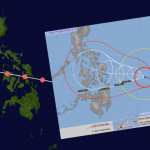
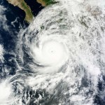
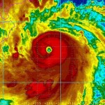
Super Typhoon Hagupit is on its way to the Philippines. The image above shows the storm track for Typhoon Haiyan, which was a very damaging super Typhoon that came through the same area last year, and served as an example of climate change making things worse. The smaller map is the Japan Meteorological Agency's prediction of Hagupit's path. They are very very similar.
Hagupit will not likely be as strong as Haiyan (see details here) because the region does not have the extra warm deep water that supercharged Haiyan. But Hagupit is still going to be a bad storm.
The Road to Paris is a web site created by the ICSU, "...a non-governmental organization representing a global membership that includes both national scientific bodies (121 National Members representing 141 countries) and International Scientific Unions (30 Members)," founded in 1931. If the ICSU had not existed when the UN was formed, the UN would have formed it. Think of the ICSU as the UN of Science. More or less.
(Follow Road to Paris on Twitter.)
Anyway, Road to Paris refers to the 2015 international meetings on climate change, and the purpose of the web site is to provide excellent…
The term "Polar Vortex" was thrown around a lot last year, in reference to the persistent mass of very cold air that enveloped much of southern Canada and the US. As you will remember, Rush Limbaugh accused climate scientists and librul meteorologists of making up the polar vortex to scare everyone into thinking climate change is real. You may also remember Al Roker pointing out on national TV and on Twitter that the term "polar vortex" has been in meteorology textbooks for decades.
This year, with a new wave of cold air arriving unseasonably in the upper middle part of the US, the term is…
There has not been much hurricane activity in the Atlantic for a while now, so unsurprisingly the reporting is starting to slip again. This post goes out to all you reporters at CNN and Reuters and Yahoo and everywhere else. Imma give you an example of what you are doing wrong, then I'll send you to a place to learn up on it.
A recent report noted that "hurricane force winds are now bearing down on Bermuda, and the storm is expected to arrive within hours" meaning the eye would arrive within hours (paraphrased). This is not what is happening. When there is a hurricane arriving at your…
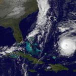
Atlantic Hurricane Gonzalo is a Major Hurricane, Category 3 at the moment, and it is heading towards Bermuda. The storm will weaken a little bit before getting there but it will still be major. This is a significant event. It is possible that a storm surge of about 10 feet could occur there. Gonzales will be very near Bermuda in by Friday Evening, and past it by Saturday morning.
Interestingly, Gonzalo is expected to remain a hurricane strength storm (though it may be called a "post-tropical cyclone" it will still have sustained winds at hurricane level) as it passes the Canadian…
The American Meteorological Society, in it’s Bulletin of the American Meteorological Society (BAMS), has released a report called “Explaining Extreme Events of 2013 from a Climate Perspective.” Three studies looked at excessive heat in Australia, three at drought or dry conditions in California, and 14 looked at various other extreme events (though some of those events may overlap or be related) for a total of about 15 different phenomena.
There was a pattern in the results. The studies looking at heat all suggested a link to anthropogenic global warming (AGW). This is not surprising because…
The Polar Vortex hurt. We who lived in it, through it, with it, are like farm animals that got zapped by the electric fence a couple of times ... notice all that long grass growing by the fence. Stay away. It hurt! So we are worried that this will happen again.
It is a reasonable worry, from a scientific point of view. The Polar Vortex visitation last winter was the result of changes to trade winds and jet streams that has characterized our weather for the last few years. One of the big questions on my mind is this: Are wavy jet streams and corresponding changes in the distribution of…
Odile was the strongest hurricane to strike the Baja Peninsula during the period of available data, roughly similar to Hurrican Olivia (1967). The storm reached Category 4 strength but was then weakened because of interaction with the effects of a prior hurricane in the area (Norbert). At the moment, Odile is a tropical storm and still in the Baja. There was flooding, and two fatalities, including a lightning strike and a nine year old boy taken by floodwaters. Several building in Acapulco were damaged. There has been a lot of damage and disruption in the Baja region.
Tropical Storm Polo…

Al Franken likes to joke about having run the most efficient campaign for Senate ever, referring to when he beat incumbent Norm Coleman by just a couple of hundred votes (on the first count ... the number went up during the grueling recount). Now, we have an example of the most efficient ever tornado hunt.
This is in Russia where, apparently, every single vehicle has a dash cam just in case something interesting happens. You see the guy back out of his garage, see the tornado coming down the street, and when he tries to drive back into his garage for safety ... well, just have a look:
Hat…

According to John Berger, author of the newly released book Climate Peril: The Intelligent Reader's Guide to Understanding the Climate Crisis, time is running out. The climate is changing in ways that will bring unwanted results, and we as a species are slow off the mark to do something about it.
Climate Peril: The Intelligent Reader's Guide to Understanding the Climate Crisis begins with a description of the global climate in the not too distant future, 2100. It is of course a guess, perhaps fiction. But Berger's description of the world in 2100 is plausible, and much of it probable. We…
A new paper advances our understanding of the link between anthropogenic global warming and the apparent uptick in severe weather events we’ve been experiencing. Let’s have a look at the phenomenon and the new research.
Climate Change: The Good, The Bad, and the Ugly.
It is mostly bad. Sometimes it is ugly. I was looking at crop reports from the USDA and noticed an interesting phenomenon in Minnesota, that is repeated across much of the US this year: Fewer acres are in crops but among those acres that are planted there is a high expected per-acre yield. The higher yield will make up for the…
Lots to talk about here:
Published on Aug 1, 2014
Arctic Emergency: Scientists Speak On Melting Ice and Global Impacts (1080p HD)
This film brings you the voices of climate scientists - in their own words.
Rising temperatures in the Arctic are contributing the melting sea ice, thawing permafrost, and destabilization of a system that has been called "Earth's Air Conditioner".
Global warming is here and is impacting weather patterns, natural systems, and human life around the world - and the Arctic is central to these impacts.
-------------------------------------------------
Scientists…
I don't like the messaging Holdren almost always seems to start with: "While we can't attribute a single bla bla bla to climate change" (it is not the right way to phrase what is happening, this is a good video just out:
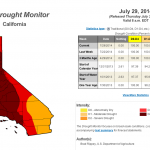
The US Drought Monitor produces an assessment of drought conditions every week. The drought in California has taken a large jump over the last few days, with the highest category, "Exceptional," jumping from 36.49% to 58.41%. At the start of the calendar year, that category was represented in California by 0%, so this is a continuation of an ongoing trend. The image above is the current map from US Drought Monitor.
I made a couple of other graphics that demonstrate the problem.
This is the percent area in California covered by severe to exceptional drought since the most recent time that…
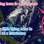
There is a major typhoon (hurricane) in the Western Pacific, Rammusan, which has already caused flooding and damage in the Phillipenes, where it killed 12 people, heading for southern China, and expected to affect northern Vietnam later on. From Accuweather:
Warm ocean waters combined with light wind shear will allow the storm to remain well organized through Friday as it approaches Hainan Island. Rammasun will likely bring widespread winds of 100 mph to northern Hainan Island on Friday afternoon and Friday night with higher gusts. Widespread wind damage is expected across northern Hainan,…

Possibly both.
Climate change certainly has a huge effect. Increased evaporation, decreased snowpack, the stalling of air masses that cause more drying and less wetting, which in turn is caused by changes in the jet stream, which in turn is caused by "Arctic Amplification," an effect of global warming, are major causes of a three year drought coming hard on the heels of a decade of near-drought dry.
But also, Californian approaches to water management have been an issue. I recently learned that there are communities in California that don't even have water meters on people's houses. What…
Update:
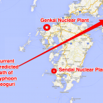
The new forecast track of Neoguri is shown above as well as the location of two nuclear power plants.
The forecast track has moved south, and is now in a very good (and here good means bad) position to strike the Sendai nuclear power plant very directly. Keep in mind that this forecast may change.
On Tuesday mid day UTC the storm will likely be in the later phases of a turn to the right, aiming roughly at the Sendai plant. At this point maximum wind speed near the center of the storm will likely be about 90 mph, which puts the storm in the middle of the Category One range. That…
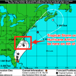
The Hurricane may (or may not) directly strike the Outer Banks.) I've updated the title of the post to update concern that Hurricane Arthur has a much increased chance of directly striking coastal regions in North Carolina. Scroll down to the most recent update below to find out more. I'm adding updates to a single post rather than writing new posts because I'm almost out of paper for blog posts. No, not really, it does not work that way. I'm doing this as an experiment in keeping things organized, especially handy-dandy images of the process unfolding.
The previously mentioned tropical…
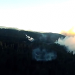
First let me check ... are all those denialists who have been claiming that wild fires have become rare done talking yet?
OK fine.
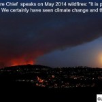
Yes, depending on where you go and what you look at we are having a problem with wild fires in the US and elsewhere (i.e., Australia). Part of this is probably due to weather whiplash. Periods of heavier than usual rain means more fuel grows, periods of dry make the fuel ready to burn, maybe even add some extra windy conditions, and the fires are worse than usual. This leads to landslide conditions being worse later on when the unusual rains occur.
Anyway,…