Severe weather
From Paul Douglas:
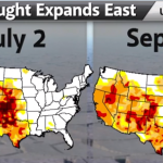
Much of the Upper Midwest could use a good soaking. Hard to believe when we started July, most of the Midwest was drought free. WeatherNation Chief Meteorologist Paul Douglas says in 35 years in the weather business, he's never seen such sudden changes. Hence the term: "Flash Drought"
As you know, if Tropical Storm Humberto, which is out in the eastern Atlantic at the moment, turns into a hurricane AFTER noon tomorrow, September 11th, it will break the record for latest first hurricane in the Atlantic hurricane season for the period of good records. Everyone was expecting Humberto to ramp up hurricane intensity today, but strengthening of the storm has stalled a bit, and Humberto is not as organized as expected.
Officially, the National Weather Service predicts that Humberto will be a hurricane later today. But it is possible that this won't happen. We will be watching…
The disturbance off the west coast of Africa that I mentioned earlier is now officially Tropical Depression Number Nine.
It is forecast that Nine will turn into a hurricane in about 72 hours, though one model suggest much sooner.
The last time that no hurricane formed in the Atlantic before September 11th was ... well, never (for the period of good records). So if the Nine becomes Humberto (that's the next name on the list) a little late, on the 12th, Humberto becomes a record storm, of sorts ... the first hurricane after the longest delay in the Atlantic. If, however, Nine becomes…
We are two days away from the peak day for hurricane season (with many more days of hurricane season coming, of course). Yet there have been no Atlantic Hurricanes. In just a few days (on September 11th) if we don't have a hurricane, we'll break the record for latest over the period of record keeping.
There is a storm forming off the coast of Africa that might become a hurricane before September 11th. Or maybe not. The race is on!
Anyway, Paul Douglas of Weather Nation has a video explaining the current situation:
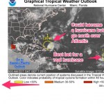
Over the last several days the Atlantic has been very active, producing numerous storm systems that had promise to turn into something. Only one did, Gabrielle, and Gabrielle downgraded to a stormy blob (#1 on the above graphic from the National Weather Service). Gabrielle may well be back as a tropical storm, but there is only a small chance of that. If exGabrielle does turn into something it will most likely go straight north in the Atlantic. The second item is something that the NWS hurricane people have been watching since it was over the Sahara, hinting in their regular updates that…
I love it when controversy develops in climate science. It demonstrates that climate science is a science, not dogma. Also, it is interesting. And, ultimately, it is important because we need to reduce uncertainty and addressing controversy eventually does so.
There is a new controversy in climate science about a vitally important issue. Last year, Hurricane Sandy (aka Superstorm Sandy aka Frankenstorm Sandy) devastated coastal New Jersey and flooded the Battery in Manhattan. This was a highly unlikely event. Estimates of how likely it is for a major hurricane to follow the path Sandy…
First, watch it:
Then, go here to sign the petition!!!!!
A while back a few of us were talking about naming storms and droughts after climate denialists. Maybe this petition will help make that happen!
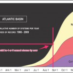
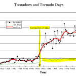
So, how has the Atlantic hurricane season shaping up so far?
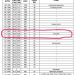
According to data accumulated by the National Weather Service, as shown (with added items) here ...
... we should have had about four or five named storms at this point in the season. Since numbers for this time of year are small, variation is large, so this is not too meaningful but it can give us an idea.
So far, we have had these storms in the Atlantic:
Tropical Storm ANDREA
Tropical Storm BARRY
Tropical Storm CHANTAL
Tropical Storm DORIAN
Tropical Storm ERIN
The next storm will be named Fernand, and it may be forming as we…
Paul Douglas has also been following the Al Gore OMG Category Six!!1!!! discussion. Here's what he has to say about the thing I just wrote about:
I'm thinking we might need to add some degrees onto the thermometer next week!
These things are all connected.
A couple of days ago a good ally in the climate change fight ... the fight to make people realize that climate change is not some librul conspiracy to raise taxes on the rich ... goofed. It was a minor goof, barely a goof at all. We do not yet know the nature of the goof but it was somewhere between saying something in a slightly clumsy manner and a bit of misremembering something that happened in 2005 during an interview. That's it. Nothing else to see here.
But that goof has been wrenched form its context and turned into a senseless and embarrassingly…
There are at present two systems in the Atlantic that have a good chance of producing tropical storms and possibly, eventually, hurricanes. One is east of the Yucatan, the other is very near the coast of West Africa.
Here's the report from the National Weather Service. I've used a rough routine to convert case so it is not screaming at you (the NWS has not yet implemented the rumored policy of not using ALL CAPS FOR EVERYTHING.
1. The broad area of low pressure in the northwestern caribbean sea is moving toward the west-northwest at 10 to 15 mph. Cloudiness and showers associated with…

Dorian is a tropical storm that formed in the eastern tropical Atlantic ago. Dorian is probably going to head almost straight west-northwest and menace the vicinity north of the Greater Antilles and the Bahamas. This is going to take some time. By the end of the weekend, Dorian will be encountering islands in the northeastern Caribbean as a topical storm, most likely. The chance of Dorian remaining as a storm (as opposed to regressing to a depression) or strengthening from storm to hurricane is not at all large. But, unlike some others storms we've seen lately, Dorian seems to gain a little…
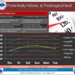
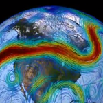
This is just a weather prediction, so it is subject to revision, but the National Weather Service is expecting an historic heatwave in the American West next week, probably peaking next weekend. Temperatures in Death Valley will approach 130 degrees F, and Las Vegas will top 115 degrees F, if predictions pan out. The heat wave may extend to the Canadian Border.
From Andrew Freedman at Climate Central:
The furnace-like heat is coming courtesy of a “stuck” weather pattern that is setting up across the U.S. and Canada. By early next week, the jet stream — a fast-moving river of air at…
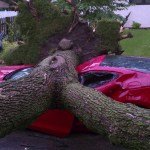
The video below has meteorologist Paul Douglas talking about the big storm we had in the Twin Cities a few days ago (from his excellent series of climate change and weather related videos). The storm actually followed on a number of days with a fair amount of rain, and up here in the northern part of the Twin Cities, we had a pretty bad blow with high wind gusts and lots of rain the day before. But on the 21st, a storm swept mainly through the Western Suburbs and Minneapolis, but actually a much wider area than that. I drove down to pick up Julia near Roseville yesterday, a couple of days…
I think most people will agree that in North America (and other places) we've been having some bad weather. Some of the weather is not necessarily intrinsically bad ... so what if it is a little cooler or a little warmer than you expect. Aridity? Deserts are nice! Extra rainfall? Great for the plants. But actually that sort of thing has its down side since important systems like agriculture, the water supply, and Spring Break work reasonably well because of expectations that might not be met if the weather is different.
Other weather is intrinsically bad. I'd mention tornadoes but at the…
UPDATE (March 2017):
At the time that Samaras, his son, and his colleague, were crushed to death inside their tornado-chasing car, which was apparently rolled by the force of 200-300 mile an hour winds over a distance of a half mile or so, it was said by numerous news sources that this car had been trapped by a traffic jam caused by looky-loos who wanted to see the tornado and/or people sent out on the roads by a local weather reporter to "escape." So, that apparent fact was part of the underpinning of the original post (below).
Later analysis of the situation indicates that there was…

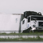
Tim Samaras, his son Paul Samaras and their colleague Carl Young were killed yesterday when their research vehicle was crushed almost beyond recognition by a Tornado they were "chasing" in Oklahoma.
If you ever watched Storm Chasers, the show on Discovery Channel (it is on Netflix) you may know of these guys. Tim Samaras's team was "TWISTEX" ... they drove pickup trucks with extremely well engineered systems for deploying "probes" that would collect data from tornadoes passing overhead. Their methodology was to get in and out before the tornado came through, and to the extent that we can…
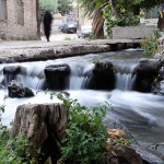
A quaint New England rocky creek
Imagine standing next to Parable Creek, an imaginary rocky brook in New England. The water is rushing past you from left to right, around the rocks that emerge tall above the surface of the stream, mounding over the top of those that are lower down. The deepest parts of the steam are relatively flat but show ripples that belie the presence of other rocks and sunken branches that are well below the water line.
While you are observing a young boy of about 11 years old comes along, carrying his fishing pole. “Hey mister, how’s it going?” he says, as he steps…
There are good reasons to believe that global warming leads to more storminess, but the exact nature of that transition is unclear and hard to measure. Part of the reason for this difficulty is that a given type of storm may become more likely under certain conditions caused by climate change, while a different kind of storm may become less likely, with the "storminess" overall increasing but doing so indifferent ways across time. Also, the most severe, and thus possibly the most important, weather events are infrequent so it is difficult to see changes over time with any statistical…
Why is it snowing so much in the Northern US States this Spring? Two words: Global Warming. Let me ‘splain.
Weather is all about air and moisture. The distribution of air is uneven, with some places having more air in big piles, other places having less air, into which the extra air from the big piles of air tends to spill. The big piles form because the surface beneath is relatively warm, causing the air to expand more than in adjoining areas. As air falls off these giant mounds of seeming nothingness, it forms low pressure systems that consist of swirling moving masses, made up of air of…