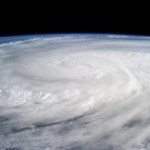
Severe weather
Please join us. It will be at the West Metro Critical Thinking Club on Saturday, December 28, 2013, at 10:00 AM at the RidgePointe Senior Apartments on 12600 Marion Ln. W, Minnetonka, MN.
I know these people. This will be a tough audience. This is a well educated and thoughtful group. Also, there are many climate skeptics in the group, and a talk given last September that questioned the strength of the evidence for Global Warming was well received. So, this is going to be interesting and fun!
Here's the writeup for the talk, and more info can be found HERE:
The Global and Local…
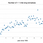
Are there more tornadoes because of global warming? Are they stronger? Do they occur more frequently outside of the usual tornado season, or are they more common in areas that formerly had few tornadoes?
There are problems with all of these questions, and the main problem is the fact that the tornado data isn't very informative.
Here's the raw data from the NOAA tornado database, showing the number of tornadoes per year of all intensities greater than one mile long on the ground:
(Click on the graph to see the whole thing in case it isn't showing for you.)
This looks like more tornadoes…

From Paul Douglas at Weathernation.com:
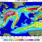
Here's a picture of the moisture in the atmosphere:
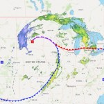
There is a storm (this one) moving across the southern part of the United States that forecasters predict will turn north over the Atlantic and menace the east coast somewhere between Northern New England and Washington DC or Virginia, possibly much of that area. The storm may develop, forecasters say, into a Nor'easter. I looked at the predicted Jet Stream configuration for next Wednesday and I noticed that is will be all curvy-durvy like it has been so often lately. This curvy jet stream is so much more common these days because, climate scientists think, of the phenomenon of Arctic…

If you are in, going to, or coming from New England, New York, New Jersey, Pennsylvania, or as far south as Maryland/Virginia/DC area, on or around Thanksgiving, you better keep track of Boreas, a storm heading in that general direction that long-range forecasts suggest might be a snow-dumping rainy windy Nor'easter.
Jeff Masters says:
(Boreas) is bringing snow and difficult travel conditions to Arizona, and will spread a variety of dangerous winter weather across Texas, New Mexico, Oklahoma, Kansas, Colorado, and Utah over the weekend. On Monday and Tuesday, the storm will dump heavy rains…

Update on Haiyan/Yolanda Death Toll
The final figures are not likely in but the numbers have stabilized and we can now probably put a number to the human toll of this storm that will not change dramatically in the future, at least in terms of orders of magnitude. The current “official” death toll in the Philippines from Typhoon Yolanda/Haiyan is 6,009 with 1,779 missing and 27,022 injured, with the largest concentration of casualties in Eastern Visayas. This comes from a December 13th report of the National Disaster Risk Reduction and Management Council, which you can (probably) download here…
Storm surges are amazing. I've never seen one happen but I've seen the aftermath. A video has surfaced of a storm surge hitting Hernani in Eastern Samar, shot from the second floor of a house that was a few hundred meters from the coast.
A storm surge is a mound of water caused by the wind of a hurricane (or other storm) pushing the water ahead of it, and further heightened by the low pressure system of the storm. In a given major storm there can be many, but there seems to be one big one most of the time. If the surge happens at high tide it is worse. If it happens at spring high tide…
There is an unprecidented high risk of significant tornado activity in your area TODAY and/or TONIGHT.
Check with the Storm Prediction Center at the NWS for the latest.
There will almost certainly be severe thunderstorms in the Mid-Mississippi and Ohio Valleys and up into Michigan today and early evening/night. It is distinctly possible that there will be tornadoes.
If there is a biggish tornado outbreak today, this may be a highly unusual weather event, and it could count in the Weather Whiplash category of climate-change caused problems.
We will be watching. But if you live in the…
Added:
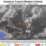
The depression has spun up to form a tropical storm. It will probaqbly remain a storm as it works its way up the Atlantic Ocean avoiding land (though it seems to be aimed ultimately at Greenland). The storm is named Melissa.
Details here.
________________
We have had a record breakingly anemic hurricane season in the North Atlantic this year. How anemic? If this year's hurricane season was a rug, you'd have a floor. If this year's hurricane season was a car you'd have a bicycle. If this year's hurricane season was a stack of pancakes, you'd have one pancake. That's now anemic.…

Trigger warning: Truth and pain.
Published on Nov 11, 2013
Philippines delegate Naderev (Yeb) Saño, announces his decision to go on hunger strike on the first day of the COP19 Climate Change Summit in Poland, 11 November 2013.
Making an impassioned plea for action by the conference, he said that he would be fasting in solidarity with his country-folk until action to prevent climate change is forthcoming.
Saño received a standing ovation after describing the hardship suffered by Filipino's, including members of his own family, due to the "colossal" typhoon Haiyan which recently hit his…

Should there be a Category 6, or even a Category 7, to classify extra bit tropical cyclones like Haiyan?
Some tropical cyclones labeled Category 5 are much stronger than others. It has been suggested that we would be smart to extend the system to have a Category 6 and maybe even a Category 7 to allow the additional severity of these storms to be indicated when they are being spoken of in the news or by officials in charge of scaring people into doing the right thing, like running away or staying indoors.
There is resistance to this proposal that comes from two mostly distinct places. One is…
At this moment, there is a guest post over at WUWT blog downplaying the size, strength, wind speeds, overall effects, and even the death toll of Super Typhoon Haiyan. Even as the monster storm steams across the sea to it's next landfall (probably as a huge wet tropical storm, in northern Vietnam and southern China), Anthony Watts and his crew are trying to pretend this monster storm didn't happen, and instead, that it was a run of the mill typhoon.
At the moment, nobody is really saying that Haiyan's strength, size, power, or even existence is specifically the direct result of global warming…
Over the last 48 hours or so a weather system slowly moved across the southern Dakotas, Nebraska, Iowa, and Minnesota. It was in part shaped and positioned by the jet stream, and it was so slow moving because of the unusually curved nature of the jet stream. This is very much like what happened a few weeks ago in Colorado, but with less of an effect. Nonetheless, there was a damage and injury causing tornado in Nebraska and Iowa, and nine inches of rain in Winona, where there was some very inconvenient flooding. The huge multi-foot snow storm in the Dakotas was part of this system. People…
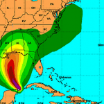
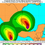
The anemic (perhaps due to climate change, perhaps not) Atlantic Hurricane Season has finally produced a storm that might turn into a hurricane and will hit the Gulf Coast.
Tropical Storm Karen is just north of the Yucatan and is strengthening and heading due north towards Louisana, Mississippi, Alabama or the Florida Panhandle with the current (and very much subject to revision!) bulls eye somewhere around or just east of Mobile.
The current projections indicate that the storm will turn into a hurricane while over the gulf, then weaken to a tropical storm before striking land. But it…

Paul Douglas from Weather Nation (and elsewhere):
For the 5th time in 23 years, the world's leading climate scientists have released an update on the state of the climate. WeatherNation Chief Meteorologist reviews the highlights plus shares the panel's predictions for the rest of the century.
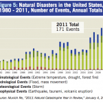
We call it "weather whiplash." This is not just meteorologists being funny. It is a phenomenon that perhaps has always been with us to some degree, but that has recently become much more common, apparently. If you were under the impression that there is a lot of strange weather going on out there, you may be right, and weather whiplash may be the phenomenon you've noticed. Importantly, there is good reason to believe that weather whiplash is the result of anthropogenic global warming. In other words, it's your fault, so please do pay attention.
Weather patterns tend to move…

There is a strong argument to be made that the recent flooding in Colorado is the result of global warming. Here are three things one could say about the flooding. Think of these as alternative hypotheses to explain that event:
1) Weather has extremes. Sometimes, instead of raining just a bit, it rains a hella lot and you get a big giant flood.
2) Weather has extremes etc. etc. but global warming tends to make some of the extremes more extremes, so instead of getting just a big flood, you get a big giant flood.
3) The storm that brought well over a foot of rain to one mountainous area was…

The big, current, story in the Atlantic is, of course, hurrican/tropical storm (there is some confusion on the status of the storm over the last 12 hours) Ingrid. Regardless of how it is classified, Ingrid is going to cause major flooding in Mexico.
But over the next several days a second and potentially very interesting but less threatening story is going to develop. The first hurricane of the season, almost breaking the record for the latest first Atlantic hurricane that we've observed, was Humberto. Humberto degraded into an unnamed storm, a bloby stormy thing, moving roughly north way…
Ingrid is serious and is going to hit something. (UPDATE: Ingrid is the second hurricane of the Atlantic Season.)
A tropical disturbance of one form or another has been hanging around since around the beginning of the hurricane season in or near the southern Gulf of Mexico, and the latest instance of this phenomenon has finally made use of very warm surface water and sup itself up into a real live tropical storm that is doing to turn into a hurricane by the end of the weekend, and hit the east coast of Mexico. This will not be a real strong hurricane but it will be VERY wet and thus…
Almost everything in the bible is exaggerated, including the floods. So when we have a flood that IS exaggerated (as a weather event) it is natural to call it biblical. The National Weather Service is calling this flood BIBLICAL (They always use all caps). Paul Douglas is calling it biblical (see below). I sent my friend the National Weather Service bulletin mentioning the biblical nature of the flood. She read my email on her cell phone while gazing at the wreckage of part of the back of her house down stream in a large river that was never there before and used to be the road, trapped at…