Soufriere Hills

Maybe I should just apologize right here and now for that title, but dang, I liked it.
Anyway, I've seen a lot of plume images cross my browser/inbox over the last day, so I thought I'd post a few of them.
Soufriere Hills, Montserrat
The renewed activity at Soufriere Hills has produced a bounty of plume images over the last week. The NASA Earth Observatory posted an image of the plume, which sometimes reached as high as 3.7 km / 12,000 feet (if not higher). Eruptions reader Alex Waning sent me some images of the top of the plume at ~3.7 km / 12,000 feet taken from a flight near Montserrat on…
We get a new update from the Smithsonian/USGS Global Volcanism Program ...
Highlights (not counting Soufriere Hills or Gaua) include:
The Weekly Report mentions the mystery eruption/noneruption of Karkar in PNG. Specifically, they report:
The report also stated that ash had merged with a thunderstorm cloud and had become unidentifiable.
Two ash plumes (11/25, 26) that reached at least 9.1 km / 30,000 feet were reported by the Darwin VAAC ... but as we know, it is far from clear that anything actually happened at Karkar last week.
Activity has quieted significantly at Chaiten in Chile, with…
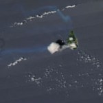
An ash plume from Soufriere Hills on Montserrat, taken from the ISS on October 11, 2009.
If you ever wonder what might happen to the U.S. if a large volcanic eruption, lets say from Rainier or Long Valley or Shasta, occurred, you can look at the island of Montserrat for some of the potentials problems. The renewed activity at Soufriere Hills (video link) that started in October is causing problems with the power infrastructure of the island - specifically the ash from the eruption is falling on power lines and damaging them. Ash has a minor electrical charge, so it will coat anything with a…
Back to work after Thanksgiving Break ... lets clean up a few news items I missed trying to figure out the non-eruption of Karkar.
Undated photo of the summit area of Gaua, Vanuatu.
There was an actual eruption - or, more correctly, a continued eruption - of Gaua in Vanuatu. The current activity has prompted the evacuation of 300 villagers from the island and they will not be able to return until activity wanes. Tourists were also told to stay away from the volcano, but the airport on the island has not been affected by the eruption, which might suggest the activity is relatively localized…
The latest of volcano news from around the world, brought to you by the USGS and Smithsonian Institute Global Volcanism Program (and especially Sally Kuhn Sennert!)
Highlights this week include:
Karangetang in Indonesia produced a couple 3 km/10,000 foot steam-and-ash plumes according to reports from pilots.
Soufriere Hills on the island on Montserrat has had quite a few pyroclastic flows over the last few weeks since the volcano started erupting again. Mix that with some heavy rainfall and lahars were produced as well.
The alert level is still at Orange at Karymsky in Kamchatka, which…
I did an excellent job of forgetting my notes from GSA 2009, so no wrap up on the meeting until tomorrow, but we do have some new volcano news to digest:
The crater of El Reventador in Ecuador in an undated photo.
Ecuadorian officials have called for evacuations around El Reventador. The Ecuadorian Geophysics Institute says that the volcano's "activities were measured at a level considered high, with permanent seismic signals indicating explosions while the southern side of the volcano crater could be seen as incandescent.". Three provinces near the volcano were put on alert evacuated as a…
Before we get to the latest SI/USGS Weekly Volcanic Activity Report (WVAR), I wanted to draw your attention to some nifty NASA Earth Observatory images from the current activity at Soufriere Hills in Montserrat. After a few puffs last week, the volcano is now releasing a relatively constant stream of ash and steam, this after ~10 months of quiescence. The two images, one on October 12 and one on the 13th, suggest there is a lot of a variability, day to day, in the plume. See the latest WVAR for more info on Soufriere Hills.
On to the Report!
Highlights this week (not including Soufriere Hills…
Sometimes it is hard to keep up with the mountain of remote sensing (or not so remote) images that get released on the internet. Over the last few days, the NASA Earth Observatory has released a bunch of images/videos of current eruptions, so I thought I'd round them all up here for you to peruse.
Soufriere Hills releasing puffs of ash-and-steam on October 6, 2009. Image courtesy of the NASA Earth Observatory.
Four new images in the recent past:
A nice, clear picture of an ash-and-steam plume from Rabaul in PNG was captured by the Terra satellite's MODIS imager on September 30, 2009. The…
Two volcanoes that have been rumbling and rocking for a while now made some noise today:
Kliuchevskoi Volcano in Russia.
Soufriere Hills on Montserrat had a relatively impressive explosive event, producing a ~3 km / ~11,000 foot ash plume - its first eruption in 10 months. This was after a sharp increase in seismicity at the West Indies volcanoes since Sunday. This is a bit of a surprise as the eruptive period at Soufriere Hills was seen to be coming to an end - however, this eruption isn't really anything out of the ordinary according to James White Jr., the acting director of the…
Monday is here again already ...
A pyroclastic flow from Soufriere Hills heading towards the ocean. Note the large volcaniclastic debris fan being formed by repeated flows. Dated March 2006.
The "Science Advisory Committee" at Montserrat in the West Indies suggests that the current eruption of Soufriere Hills on the small island could be drawing to a close. This is mostly based on the ever-decreasing seismicity under the volcano and that the volcano has not experienced any new dome growth or explosions over the last 6 months. Gas emissions have remained relatively constant over the last 18…
Some brief notes before I dive headlong into the exciting world of faculty orientation!
A small steam plume coming from Turrialba in Costa Rica. Photo taken in August 2007.
There are some preliminary reports of the state of wildlife (and everything) around Kasatochi Island in the Aleutians from the US F&W and USGS team that headed to check out how the island has recovered since last year's eruption. The shoreline has been radically transformed by the ash and although some seabirds have made attempts to nest in the loose ash, it doesn't seem to have been very successful. However, not…
Time to vote for the next Volcano Profile. Feel free to leave any comments or suggestions after answering the poll!
What should be the next volcano for the "Volcano Profile" series?(surveys)
Chaiten in Chile erupting in January 2009. Even after over a year of activity, Eruptions readers are still captivated by the volcano.
Thanks for sending me your questions about volcanoes and volcanism. I'll try to tackle some hear - but as always, keep the questions coming! Send them to
For those of you who have submitted a question but don't see the answer here, do not fret. Likely it just means that I needed to do a little more research into the question and will get to it in a later mailbag!
So, without further ado ...
Mark M.: Here in the Appalachians we have very dense crystalline rock…
We've already talked about how many active volcanoes reside in Indonesia, but this week's USGS/SI update just drives that point home. Listed in the update are no less than 5 volcanoes were activity is being seen or is on the increase (Karangetang, Slamet, Dukono, Batu Tara and Makian). This doesn't mean mention the activity at Anak Krakatau, Rinjani or Semeru. Amazing.
Anyway, highlights - not counting Indonesia or the South American trio - from this week's report (as usual aptly put together by Sally Kuhn Sennert) include:
A ~8,000 foot / 2.4 km ash and steam plume from Bagana in Papua New…
The clock is ticking for the new dome growing at Redoubt to collapse. What will happen if/when it does collapse? Good question!
The new dome at Redoubt. Image courtesy of AVO/USGS, taken by Game McGimsey, April 30, 2009.
Most likely, the following will occur:
First, extrusion of lava will cause the dome to over-steepen, precipitating the collapse (although a large seismic event could also trigger collapse as well). An excellent example of this is the spine that grew at Mont Pelee on Martinique in 1902 before the famous eruption that destroyed St. Pierre and killed >30,000 people.
When it…
Image courtesy of Calvin Hall. Taken 3/28/2009 during an eruption at 10:59 AM3:28 PM.
UPDATE 4/2/2009 at 11 AM Pacific: I'm moving this up from the comments, but Eruptions reader Doug Cole pointed out (and I have no idea how I missed this) that Redoubt has a new webcam! This one is at the DFR seismic station, ~8 miles / 12 km northeast of the volcano. Great views on it today showing the extent of the ash around Redoubt and the steam/ash plume. This view will also be excellent if we get any dome collapse pyroclastic flows (see below).
After a week of explosions and ash fall, Redoubt seems to…
The latest eruption of Sourfriere was captured from space, and NASA has just released the MODIS picture of the volcano in action. The image (above and linked) was taken 2 days after the first explosion of this unanticipated and unexpected eruption - December 4. You definitely get the idea of how much of the island of Montserrat is taken up by the volcano itself (pretty much all of it). Not much else to report on Soufriere Hills beyond the update from MVO (via SI/USGS) for the end of last week:
On 3, 4, and 5 December small, relatively slow moving pyroclastic flows traveled no…
The blasts and pyroclastic flow from earlier this week at Soufriere Hills in Montserrat were not the only show planned for the week, apparently. The volcano continues to erupt, with reports of continued ash and ballistic glowing bombs being erupted. These eruptions are the first major ones at Soufriere Hills in 6 months, but are apparently unique with no real precursors such as seismicity (well, none identified as of yet).
Just to keep everyone on their toes, Soufriere Hills on Montserrat in the West Indies erupted today. The eruption produced a number of explosions and a pyroclastic flow that originated from the west side of the lava dome at the summit of the volcano. However, the most interesting bit comes from the Montserrat Volcano Observatory (MVO) report I received this morning:
"The explosion happened without any warning. There was no precursory seismic activity."
Sounds like it could have been a dome collapse caused by a rapid release of gas/steam? The explosion apparently threw blocks as far as…
So, I get a steady diet of email messages here at the Eruptions HQ, so I thought I could try a little roundup of the great information/links that you readers are sending (and I apologize for taking so long for some of these). Enjoy!
- Tim Stone tells us about GeoEye pictures of volcanoes. GeoEye is the new satellite launched to add to the Google Earth images of the planet. There are some quite striking images of volcanoes included in the collection.
- Richard Roscoe sends us to some updated images of the on-going volcanic activity on Montserrat. As usual, there is an abundance of…