Hurricane
Update Thursday AM
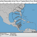
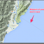
As expected, Nate emerged as a named storm over night. The storm is now interacting withland in Central America and is therefore having trouble getting organized. And, as expected given the uncertainty this causes, the forecasts are unclear on future intensity. The most recent National Hurricane Center projection has Nate Maxing out as a much weaker storm than yesterday's projection suggested. And, the center of the expected path of the storm has shifted west and is now centered roughly on New Orleans.
After leaving Central America, Nate is expected to pass just over the…
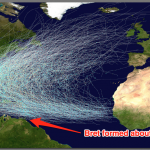
As you already know, Hurricane Maria is a Category 5 storm menacing the Leewards, and heading, likely, for Puerto Rico.
Please avoid making the mistakes that were made in talking about Irma. There will probably be no Category 5 storm hitting Puerto Rico. The storm will probably be a Category 4 before it hits. So, reporters will sloppily declare that "a category 5 storm is heading for Puerto Rico" then later Rush Limberger will say "Look there was never no such storm, see?" and so on.
But, a Category 4 storm is still nothing to sneeze into, and Puerto Rico and the other island in this storm's…

Three statisticians go hunting for rabbit. They see a rabbit. The first statistician fires and misses, her bullet striking the ground below the beast. The second statistician fires and misses, their bullet striking a branch above the lagomorph. The third statistician, a lazy frequentist, says, "We got it!"
OK, that joke was not 1/5th as funny as any of XKCD's excellent jabs at the frequentist-bayesian debate, but hopefully this will warm you up for a somewhat technical discussion on how to decide if observations about the weather are at all explainable with reference to climate change.
[…
UPDATE Sept 9, AM
Note that tropical storm force winds may start hitting southern Florida around 1 or 2 PM today, Saturday, and will reach central Florida by about 8AM Sunday.
The eye of the storm should be abreast southern Florida at around sunup on Sunday. The storm may remain a major hurricane as it moves all along the west coast, reaching south of Tallahasse, still as a major hurricane, Monday morning.
Irma has interacted with Cuba more than previously expected. The storm also seems likely to move farther west than previously expected.
Moving over very warm waters over the next…
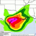
Harvey the Hurricane will hit Texas roughly between Corpus Christi and Victoria (but stay tuned for exact details).
Harvey is passing over water that is significantly warmer than usual, owing to global warming. This storm was too disorganized to even, under normal conditions, to have a name, just a day or so. But, when this storm hits Texas late this week (maybe by the time you are reading this) it is likely to be a Category III storm.
Then, after landfall, the storm will hang around that area for a while dumping huge amounts of rain on the Texas flatness.
The target area may have 15 inches…
UPDATE (Aug 30th)
Irma is a new named storm in the Eastern Atlantic. See this post for details, eventually.
UPDATE (Aug 29th)
There is a system currently raining on Cabo Verde, off the West Coast of Africa (nee Cape Verde) that is expected to develop. It is on the verge of becoming a tropical depression. The National Hurricane Center has estimated that there is a high probability of this stormy feature becoming a tropical storm in a couple of days or so. If it gets a name, it will be Irma, unless some other large rotating wet object takes that name first.
UPDATE (Aug 29th)
How is the…
This is a bit late in the year for an Atlantic Hurricane. The season normally runs from June 1st through November 30th, but that includes a bit of buffer time.
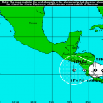
Otto is a tropical storm that will turn into a hurricane on Wednesday, probably, and make landfal near the border of Nicaragua and Costa Rica. Expect coastal flooding as well as serious inland flooding. The storm will arrive in the Pacific on Friday as a tropical depression.
Then, we'll have to see if it turns into something in the Eastern Pacific basin.

This morning I was forced to do the "get off my lawn" thing with the kids at the bus stop. They were systematically destroying the pavement around the common mailbox area down the street from my house, throwing chunks in the street. I lined them up and read them the riot act. They are children, so they can be excused for bering a bit stupid about life, and the guy down the street telling them to get off the lawn is part of the learning process for them.
And now it's your turn.
The right wing yahoos have already started yelling about conspiracies related to Hurricane Matthew. "They are…
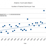
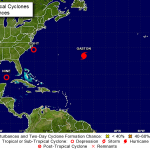
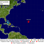
The 14th named storm has just appeared in the Atlantic.
The average number of named storms in the Atlantic, based on a fairly long climatology, is about 10.1. An average of 5.9 become hurricanes.
So, this year are more than average named storms. But is it more than predicted?
On average, the expert forecasts suggested anywhere from 12 to 18 named storms. We are well past the midpoint of the 2016 season, and are just about to reach the midpoint of these forecasted ranged, and there is still plenty of time left for a few more storms. The largest number predicted, as the upper end of the…
LATEST UPDATE IS HERE. CLICK HERE FOR LATEST UPDATE.
Update: Wed Mid Day
Matthew weakened, strengthened, strengthening
Matthew has interacted with land masses in Hispaniola and Cuba to the extent that the storm weakened quite a bit, losing its temporary Category 5 status.
But, now Matthew is already showing signs of strengthening, and is likely to grow back to Category 3 or 4 status as it moves over the Bahamas. How bad a hurricane is when it makes contact with land depends in large part on the angle of the attack, and Matthew will likely be affecting several spots in the Bahamas at a…
Update (Mid day Wed):
The disturbance in the eastern Atlantic is now a depression, and it is reasonably likely that it will be a named storm by mid day tomorrow, Thursday.
The predictions for the next several days do not have this storm turning into a hurricane any time soon; it should remain a storm or a depression, possibly going back and forth between the two, for four or five days, but after that, perhaps it will turn into something. Or not. Keep an eye on Karl, if this becomes Karl.
Meanwhile Julia is annoying people in the Southeast, but not doing much. However, keep an eye out for…
Wed AM Update:
Meranti passed near the southern tip of Taiwan, and apparently it was pretty windy and nasty there. But, Taiwan has invested heavily in infrastructure with the idea of being hit with giant typhoons now and then, so things were not as bad as they could have been.
apparently Meranti is now a category 5 equivalent heading for China. The storm is expected to weaken only a bit as it makes landfall (see this post on what landfall means) so this is going to be a direct hit by a major hurricane. There are some pretty densely populated areas in the storm's path. There are also many…

Update: Mid Day Monday:
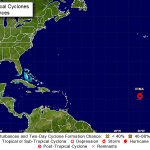
Ian is no longer a glimmer in the eyes of NWS forecasters. Ian is now a tropical storm. However, Ian is about to head north over unfavorable waters, will likely never develop hurricane strength, and is not expected to hit anything big. (See map above.)
Nothing else is really happening in the Atlantic at this time, wrt storms. There is a disturbance in the Lesser Antilles, which is not likely to do anything more any time soon, if at all.
Update: Monday AM:
Yes, the chances that a tropical storm that has been tracked for a few days now as a disturbance will form today…
Update (Sunday PM):
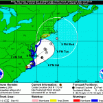
Hermine is still a big storm and will affect eastern regions to some degree, but the storm never reformed as a hurricane, and is not not expected to do so. Also, the storm has jinked out to the east more than expected and will likely move farther east. So, there will be some coastal effects, but not much out of the ordinary.
POST-TROPICAL CYCLONE HERMINE FORECAST/ADVISORY NUMBER 30
NWS NATIONAL HURRICANE CENTER MIAMI FL AL092016
2100 UTC SUN SEP 04 2016
CHANGES IN WATCHES AND WARNINGS WITH THIS ADVISORY...
A TROPICAL STORM WARNING HAS BEEN ISSUED FROM WATCH HILL…

Update (Noonish Friday):
Lester is going to skim along to the north of the Hawaiian Islands. This is an estimate of the probability of the distribution of 50mph winds:
Surf's up, it will be stormy, but the significant threat is moderate.
Update (Noonish Thursday):
Madeline sort of hit Hawaii, but it also did a funny little shrug as the medial to outer bands got close to the big island, and the rematerialized on the other side, keeping with the mysterious tradition (see below) of hurricanes magical avoiding the island state. But, the storm surge did in fact swamp a lot of places along the…
Original Post:
The Atlantic storms are getting interesting.
Two different systems are poised to become named storms, but it is not clear which one will be awarded the name Hermine, and which one Ian. If the storm recently near Cuba develops as expected, it could become a weak hurricane before making landfall along Florida's Gulf coast. This will not likely be a very impressive hurricane, but it will be big and wet, and the area is already experiencing too much water. Flooding will ensue.
A third system is moving off of Africa, with 40% chance of forming into a storm over the next several…
A quick note about the current Atlantic hurricane season. With resect to just the US, we've had a fairly low level season, and it is easy to become complacent about this time, but in fact, the risks from Atlantic hurricanes rise about this time of year, so pay attention. Watch for Hermine. More on that below.
We are approximately in the middle of the 2016 Atlantic Hurricane Season, by calendar time. The number of named storms (tropical storms plus hurricanes) predicted for this year is about 14, taking the average of all the predictions made so far, and there have been 7 storms including…
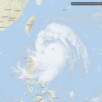
This is a huge hurricane/typhoon heading quickly, and imminently, towards taiwan.
The storm itself is roughly as wide as the island nation is long, so very little will be left unaffected.
The storm is at the very high end of the range of storms in size, strength, etc. It is currently equivalent to a Category 5 hurricane. It may weaken a bit before landfall over the next few hours, but it may remain a Category 5.
Winds, huge waves and coastal flooding from storm surges will be a big problem with this storm, but the largest problem may be the incredibly high rainfall, with about one meter of…
Monday, June 6, 9:00 PM CT
Nope. For the second time in a row, what might have been a named Eastern Pacific tropical storm will probably never amount to more than a depression and a big wet spot in Mexico.
Monday, June 6, 2:00 PM CT
The first named tropical storm in the Eastern Pacific would be called "Agatha." Rather suddenly, a disturbance in the region near Mexico has gotten itself organized, and the National Weather Service is saying that there is a 100% chance of this blob of weather turning into a named storm by the end of the day Wednesday.
We were all a bit shell shocked by…

... may or may not form over the next several days.
There is a disturbance that has a 60% chance of forming into a tropical storm some time between now and the middle of next week. This will head out to the wet and not menace the US mainland, as is typical (but not inevitable) for Eastern Pacific storms.
The main reason we watch Eastern Pacific storms is not that they are going to hit us (usually) but because they often do something interesting. And, they occasionally do hit something (remember Patricia?).
Here is the list of names for Eastern Pacific storm names for 2016:
Agatha
Blas…