Hurricane
Isaac is still not a hurricane. It will be one within 24 hours. Right? Right?
Either way, Isaac is big, wet, and windy and long before it makes landfall it will start to cause flooding and wind damage ashore, within the next 24 hours or so. There is a pretty good chance that the storm will be upgraded to hurricane status just before that. Maybe. Well, frankly, I no longer trust Isaac so I'm not making any commitments. I'm tired of these relationships when the other person storm never does what they are expected to do.
Lately the problem has been dry air intruding into the storm, which…
.... prolly. At the moment, Isaac has all the pieces in place; winds are high enough, pressure at the center is low enough, and all that. But, the storm is not organized with an eye and nicely formed bands. I imagine that the folks in the Hurricane Prediction Center are annoyed. I suspect they will declare Isaac a Hurricane within a few hours.
There are two big news items to know about. First, Isaac is physically large and wet, and will cause many inches of rain to fall on places that will then flood severely. Second, the center line of the hurricane's track may go right over New Orleans…
The good news, if you see Hurricanes as bad, is that Isaac did not turn into a hurricane over night and is having trouble getting its act together. This has caused estimates of the hurricane's maximum strength at the time of land fall to be reduced. Isaac will be a serious storm when it plows into the southern US coast but it will not be an Ivan, Katrina or Andrew.
The bad news is that the predicted track has moved even farther west, so the forward right quadrant, the "Right Punch" of the hurricane, may very well hit New Orleans at a very bad angle and position.
It is time to discuss, once again, the falsehood known as "Hurricane Landfall."
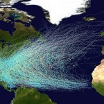
A hurricane is a whopping big thing. A hurricane can be bigger than some states. The physical region across which a hurricane is potentially deadly and damaging is very large, many tens of miles across, sometimes a couple of hundred miles across. The danger zones are often organized like this:
The central storm surge. A central region may have a strong storm surge caused by the low pressure of the storm. This may be dozens of miles wide, but the area of effect is determined as much by the shape of the coastline…
For the second time in a row, storms have interfered with the Republican National Convention. The political party that denies science, and in particular, denies climate change, that thinks NOAA built an Ark and that has no interest in the kind of regulation that saves Libertarians from themselves when Hurricanes hit settled communities, is being messed with by Big Weather.
Which brings us to our discussion of Isaac.
Isaac is still a tropical storm, and he is getting better organized, though slowly. The beginnings of an eye are becoming visible. It is expected that Isaac will become a…

"For most of the history of our species we were helpless to understand how nature works. We took every storm, drought, illness and comet personally. We created myths and spirits in an attempt to explain the patterns of nature." -Ann Druyan
Here on Earth, we are well aware of how devastating storms can be. From hurricanes to flash floods, an unpredictable change in weather can turn a serene setting into a catastrophe in no time at all. The clouds that fill the skies can often portend what type of weather is coming, and to me, the most impressive and fearsome of all is the rare and remarkable…
Let's begin with Tropical Storm Lee. There is actually quite a bit left of this no-longer named low pressure system, and it is sitting over the northern part of the East Coast producing a fair amount of rain. "So what?" you say! Good question. The thing is, that a hurricane in the Atlantic by the name of Katia (accent on the first syllable, long 'a', hard k, rhymes with onomatopoeia) is probably gong to restrain this low pressure to the region of the continent instead of letting it waft off into the North Atlantic. Likely, Katia will push ex-Lee west. So, the Eastern Great Lakes and the…
Reporter Gives Update Covered In Sea Foam: MyFoxNY.com
Given the location, New Jersey/New York metropolitan area, this part of the wikipedia definition may be most pertinent:
Where polluted stormwater from rivers or drains discharges to the coast, sea foam formed on adjacent beaches can be polluted with viruses and other contaminants, and may have an unpleasant odour.
If crude oil discharged from tankers at sea, or motor oil, sewage and detergents from polluted stormwater are present, the resulting sea foam is even more persistent, and can have a chocolate mousse texture.*
Hat Tip Joe
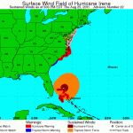
Category Three Hurricane Irene has just passed over Abaco Islands in the Northern Bahamas, and is generally affecting the northern Bahamas. Widespread damage is reported. Over the weekend Irene promises to be a very significant weather event in the US. In order to understand the events that will take place between today and early next week, it will be necessary to revisit the concept of "landfall," which we have discussed here in the past.
Here's the deal. "Landfall" is the moment in time when the eye of a hurricane contacts the land, including any barrier island or mainland. "Landfall"…
Hurricane Irene is currently located in the strip between the greater and lesser Antillies, heading west-northwest where it will seriously affect The Bahamas and related islands north of Cuba and east of Florida. By late afternoon, Irene will likely be a Category 3 Hurricane.
The storm will turn northerly over the next couple of days. Its exact track is very uncertain as it moves north along the Florida coast and roughly in the direction of the part of the US East Coast that sticks out to the east around South Carolina.
The current most likely track (with a fair amount of uncertainty)…
Technically, hurricane season has been going for a while now but I've not found any reason to start discussing disturbing weather until now. And, we have two items of interest. First, a storm is blowing up off the east coast of Florida. This is a tropical storm forming in the western Atlantic. That is not particularly strange. Most years, however, storms form by the time the associated wave has reached the middle of the Atlantic, or at least, are far enough along that you can think of tropical storm formation in the Atlantic as a phenomenon directly linked to West Africa and the eastern…
Today is the last day of the official Atlantic Hurricane season, and that seems right because for the last several days there has been no significant tropical storm development in the region. However, there is evidence to suggest that the Atlantic Hurricane seasons have been getting longer, perhaps requiring a change int he expected end date.
Well, today a storm is blowing up along side the Isthmus of Panama which has the potential for developing into a named system. The chances are very slim that this will turn into anything.
I'd love to sit and chat with you more but I have to shovel…
Observe the current Atlantic Wide satellite image from the National Weather Service:*
Look in the lower third, left side of this image, north of the South American continent, south of Haiti. You can see a blob of clouds that, especially when you look at this animation, is building in strength and organizing, and has a reasonable chance of some day becoming a tropical cyclone (this is discussed briefly here) .
But while everybody is looking at that, what about this? Specifically, that giant rotating low pressure system off the Carolinas. Isn't that impressive? It is, of course, acting…
Probably. Or, to be more exact, the seasons seem to end later these days than they did in those days, if "those days" is defined as the first decade or so during which reasonably good (though not perfect) data were collected compared to now. A more immediate question may be: When will this year's hurricane season end?
Officially, the Atlantic Hurricane Season runs from June 1st through November 30th.1
I am not certain, but it is probably the case that those dates were picked some time ago in order to include all of the days during which we were likely to have Atlantic storm activity of…
It's a relief that Hurricane Tomas didn't destroy the camps in and around Port-au-Prince where 1.3 million survivors of Haiti's January earthquake are crowded. The storm hit western Haiti hardest, causing flooding and killing 20 people.
There are still concerns about how flooding will affect Haiti's cholera outbreak. The outbreak's official death toll is 544, CNN reports, and more than 8,000 cholera cases have been confirmed. So far, none of the confirmed cases is in Port-au-Prince, but 91 residents of a Port-au-Prince slums are being tested to see if they've been infected.
Cholera…
Tomas, once expected to spin up to a fairly strong hurricane, then weakened and not expected to do so, has done so. Tomas is now a serious hurricane with winds of up to 75 knots and sustained winds of 70 knots, and is expected to become stronger.
Tomas is bearing down on Haiti, but the eye is passing as smoothly as possible between Cuba and Hispaniola.
If a storm like Tomas was as close to Panama City as it is to Port-au-Prince Haiti, there would be storm studs standing along the beach in what must be rain and some wind talking about how we're all gonna die and stuff.
As it is, I have no idea what is going on there. Anybody know?
The serious part of the storm should be affecting land areas in Haiti some time tonight, and continue to do so through the day Friday into the evening. The winds will not be strong but if you live under a sheet of corrugated metal (meaning you're one of the lucky ones in this earthquake-rattled region) a 55 knot…
Tomas has been most entertaining, but now it is time to get serious. This weather feature has not exactly been a meteorological mensch but what was a depression earlier today has reformed into an actual tropical storm. It is possible that Tomas will achieve hurricane status Friday night through Saturday morning, but if so, only barely so.
Tomas will cross the western part of Hispaniola, drenching Haiti in dangerously heavy rains. The "eye" of the storm will pass father to the west than previously expected, maybe. But the track prediction for Tomas is very uncertain. The worst rains will…
This afternoon, the National Hurricane Prediction Center is using terms like "struggling to maintain its identity," "elongated area of low pressure," "losing definition," "motion is uncertain," "little change in philosophy," "cold," "guidance becomes divergent," "forecast is problematic," "the cyclone needs to survive its current state of disorganization," "if," "if," and .... "if."
If only. Alas, we must prepare to say to Tomas, "Adieu.... did we really waste a name on you?"
Or, it could turn into a hurricane in about three days. I'll keep you posted.
Tomas is like that relationship you always wanted to believe in but that never came through to you. The meteorologists at the National Hurricane Center have again and again given Tomas hurricane status when he didn't really deserve it (in my opinion) Every day, even twice a day, the meteorologists predict that the next day Tomas will be a bigger, stronger, more well formed hurricane but then that day comes along and every time Tomas disappoints (in my opinion).
And lat night, the worst thing happened.
In my opinion, anyway. Tomas became a tropical depression. A tropical depression!…