Hurricane
Update Monday June 6 AM: TropicalStorm Colin is heading for Florida.
The disturbance first noted a few days ago east of the Yucatan has moved across the mainland, into the eastern Gulf of Mexico, and with the relatively warm sea surfaces there as a source of inspiration, turned into Colin, a tropical storm.
Colin is not expected to become a hurricane, but it will make landfall somewhere on the Florida coast between, roughly, between Tallahassee and Tampa, tonight (Monday). The center of the current forecast is somewhere near Fish Creek and Steinhatchee, but that may change and this will be…
Friday, May 27, 11 AM cst
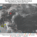
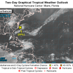
The probability of this disturbance turning into a tropical storm has been upgraded to 90%, and this transformation is expected to happen some time this evening or on Saturday.
Once that happens, the NWS will probably start issuing maps and probability information for where the storm will go and how strong it will be. For now, the NWS is indicating that "all interests along the southeast coast from Georgia through North Carolina should monitor the progress of this low."
There is not much to look at yet, but here is a moving GIF of the area. The low pressure system is…
This year's Atlantic Hurricane season will be stronger, forecasts suggest, than that of the previous two years, and stronger than the average year.
The Atlantic Hurricane Seasons starts on June 1st. But, there was a hurricane that happened already, either late in last year's season or very early in this year's season, called Alex. That hurricane had to go somewhere, and I suppose the keepers of the records had already put their spreadsheet to bed when Alex came along on January 7th, so that storm gets counted as part of the season that will nominally start at the beginning of next month.…
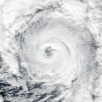
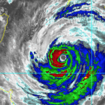
Tropical cyclone Winston is now a Category 4 storm and is probably going to make a direct hit on Fiji, tomorrow, Saturday. It will likely be a record storm for Fiji.
The storm is fueled by high sea surface temperatures, which extend to a significant depth, which probably caused the storm to intensify rapidly and to such a high state.
Jeff Masters and Bob Henson have written up the important information on this storm, here.
Fiji has been hit with a number of bad tropical storms, mainly concentrated in recent decades.
UPDATE (Friday PM Central)
Jeff Masters and Bob Henson are now…

According to Jeff Masters at Wunderblog, "The earliest named storm on record in the Central Pacific, Hurricane Pali, formed on January 7."
The storm is out in the middle of the ocean, west of Kiribati:
The reason this storm formed off season is a combination of high sea surface temperatures because of global warming and, on top of this, extra high sea surface temperatures because of El Nino. In a sense, this year is preview of what things will be like all the time, more or less, as an "average" globally-warmed year catches up to an El Niño year.

Tropical Storm Alex has formed in the Atlantic ocean. It is not entirely unprecedented to have a tropical storm form totally off season like this, but it is very rare. This happened mainly because of record high sea surface temperatures in the region.
The sea surface temperature is not enough to make a hurricane. But you know what they say about the weather -- under conditions of global warming -- wait a few years and that will happen.
Increasingly the world's oceans are losing track of their tropical storm seasons. Expect a future where tropical cyclones (hurricanes, etc.) can form over a…
I had considered writing an accounting of all the outlandish weather events of 2015, but that project quickly became a tl:dr list of untoward happenings which is both alarming and a bit boring, since it is so long. So, I decided to generate something less comprehensive, focusing more on the context and meaning of the diverse and impressive set of outcomes of anthropogenic global warming, an historically strong El Niño, and, well, weather which is already a pretty whacky thing.
See: Highlights of Climate Change Research in 2015
It should be noted right away that 2015 is the last year in which…

Update: Saturday Morning
The storm is likely to start affecting land Sunday, and to make landfall late Sunday or some time Monday, probably as a Category I equivalent.
Meanwhile this is the first tropical storm I've ever seen associated on the Internet with sites that seem to want to plant viruses on your computer. Stick with trusted sources, like the Wonder Blog or Yours Truly.
Update Friday AM:
TC Chapala is expected to be the strongest cyclone ever recorded in this part of the Indian Ocean basin. At present the storm is strengthening and is just under Category 5 strength (it will…

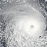
CNN is calling Hurricane Patricia "The Most Dangerous Hurricane in History." Another news outlet showed a picture of the hurricane and pointed out "The Enormous Size of Hurricane Patricia."
Both of these are wrong. Size matters with hurricanes. A category 5 hurricane that is twice as large as another category 5 hurricane is "more dangerous" all else being equal, and by "all else" I mean things like exactly where it hits, how fast it is moving, exactly how strong it is (category 5 includes a very wide range of wind speeds because it is the highest category). Hurricane Patricia is not huge.…
Update, Saturday AM:
On Twitter, people are shocked and amazed that Hurricane Patricia turned into a tropical storm. Some had prayed to god and now claim those prayers were answered. There is at least one claim of a death on Twitter, but The Twitter Lies, and this is probably someone's sick idea of a joke.
Naturally, what happened is Patricia made landfall as a very compact hurricane in a region with very few people, but as a strong category five hurricane. It had the highest sustained winds, and the lowest pressure ever observed for a hurricane, but again, Patricia was a small hurricane,…
South Carolina Floods
I haven't said much about this partly because there is so much good coverage, but South Carolina's floods, still ongoing, are going to get on the list of worst weather events of 2015. Since these floods are amounting to a one in 1,000 year event, they are actually on the list of worst weather events since Vladimir the Great died, Cnut the Great invaded Enlgand (unrelated event), Eric Haakonsson outlaws berzerkers in Norway, and Olaf Haraldson declared himself King of Norway.
And yes, that event was climate change enhanced in at least two ways, maybe three. With global…
SEE ONGOING UPDATES BELOW FOR THE LATEST INFORMATION
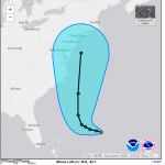
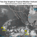
Tropical Depression Eleven is currently located way east of Florida, and is predicted to become a tropical storm by Tuesday night some time. It would be nameD Joaquin. Some time Wednesday night, the storm is predicted to turn north and head straight up along the coast. There are no significant advisories or suggestions of a threatening situation from the National Weather Service, but it is always a good idea to keep an eye on these storms.
It was predicted that there would be about 12 named storms this season. There have been 9 so far,…
Saturday Mid Day UPDATE:
Erika is now an ex-tropical storm. A real hurricane has an eye. Erika is a cartoon dead eye (see graphic above).
When the Hurricane Prediction Center woke up this morning, they found Erika, ripped asunder by the rugged terrain of Hispaniola, to have "... degenerated into a trough of low pressure."
The latest update from the NWS says, "this will be the last advisory on this system by the National
Hurricane Center unless regeneration occurs."
Which gives me an idea. If Erika, this year's Atlantic "E" storm, does regenerate into a named storm, it should take the…
First the bad news. Taiwan is going to get slammed with Typhoon Soudelor over the next day (landfall at about 8:00 AM local time). Soudelor was one of the strongest typhoons earlier during its development but weakened to a Category 1. However, very warm seas, lack of wind shear, and other factors may make Doudelor return to category 3 or even 4 strength before making landfall. Also, it is large.
The storm is likely to hit Taiwan in about the middle, which along the east coast is not heavily populated. But it will bring heavy rains, likely causing landslides and floods, to the mountainous…
But first a word bout Chan-Hom. That typhoon messed with China but not as badly as originally feared, because the storm turned to the east a bit. Now, Chan-Hom is heading for North Korea where it will come ashore as a wet tropical storm. I would not be surprised if more bad stuff happened there than with Chan-Hom's glancing blow over the last 24 hours or so.
Now I'd like to direct your attention the Atlantic Ocean for a moment. Due to vertical wind shear and aridification-induced North African dust, we have been expecting that one effect of climate change would be that most (but not all)…
UPDATE: There are significant changes (as of Friday mid day Middle America Time) in the track and strength of the storm, mostly good news for china. See here for updates.
A large typhoon (hurricane) is heading for China and is expected to make landfall in the vicinity of Shanghai. The image above is from the Japan Meteorological agency, and the image below is from JAM via Jeff Masters Blog.
"Typhoon Chan-hom as seen by radar on Okinawa at 7:45 pm EDT Thursday (08:45 JST Friday, July 10), 2015. At the time, Chan-hom was a Category 4 storm with 130 mph winds."
Apparently Chan-hom will…

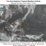
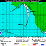
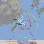
There is an 80% chance that a disturbance in the Gulf of Mexico will become a tropical cyclone, a named storm, over the next couple of days. If that happens it will be called Bill.
Possible Bill is not well defined and is poorly organized. The disturbance is currently near the Yucatan, and will move northwestward over the next couple of days where it may pick up enough energy and be left sufficiently alone to crank up. The most likely coastal area to be affected are along Texas and parts of Louisiana. Even if the disturbance does not turn into a named storm, that region will likely…

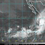
Blanca is the second named tropical storm in the Eastern Pacific. I'm pretty sure Blanca was originally a disturbance with a low probability of becoming a named storm, but I may have missed something. Blanca is intensifying rapidly and will reach hurricane status shortly if it has not already, and will likely develop to become a major hurricane. The storm is heading towards the Baja, but may weaken before it hits anything big.
Meanwhile, the first named storm of the season, Andres, is still a hurricane. Over the next few days, Andres will make a sharp turn almost in place and weaken.…
See below for update.
You may not have even noticed it, but hurricane season has officially started in the Eastern Pacific. That is because the official date of the start of season is May 15th, though the actual hurricanes rarely get the memo and start whenever they want, but usually after that date. Last year's Eastern Pacific season was much ore active than usual. The average numbers for named storms, hurricanes, and major (above Cat III) hurricanes for this basin are 15.4, 7.6, and 3.2. Last year's season was predicted to be pretty much average, but it turned out to be exceptional, with…

I remember joking with my friend Ana about how her name would be attached to the first named storm in the 2015 Atlantic Hurricane season. It turns out Ana is an exceptional individual. Both of them.
Ana Miller as Aisha Lefu in "The Recompense: A Star Wars Fan Film."
Ana, my friend, is an actor and is currently engaged in a project I'll be telling you more about later. But in the meantime, you can visit this page and find out about a new and very interesting Star Wars related crowd-funded production called The Recompense. Give them money.
Meanwhile, back in the Atlantic Ocean, Tropical…