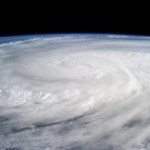
Hurricane
At this moment, there is a guest post over at WUWT blog downplaying the size, strength, wind speeds, overall effects, and even the death toll of Super Typhoon Haiyan. Even as the monster storm steams across the sea to it's next landfall (probably as a huge wet tropical storm, in northern Vietnam and southern China), Anthony Watts and his crew are trying to pretend this monster storm didn't happen, and instead, that it was a run of the mill typhoon.
At the moment, nobody is really saying that Haiyan's strength, size, power, or even existence is specifically the direct result of global warming…
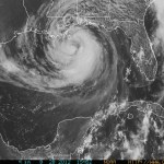
The anemic (perhaps due to climate change, perhaps not) Atlantic Hurricane Season has finally produced a storm that might turn into a hurricane and will hit the Gulf Coast.
Tropical Storm Karen is just north of the Yucatan and is strengthening and heading due north towards Louisana, Mississippi, Alabama or the Florida Panhandle with the current (and very much subject to revision!) bulls eye somewhere around or just east of Mobile.
The current projections indicate that the storm will turn into a hurricane while over the gulf, then weaken to a tropical storm before striking land. But it…

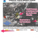
The big, current, story in the Atlantic is, of course, hurrican/tropical storm (there is some confusion on the status of the storm over the last 12 hours) Ingrid. Regardless of how it is classified, Ingrid is going to cause major flooding in Mexico.
But over the next several days a second and potentially very interesting but less threatening story is going to develop. The first hurricane of the season, almost breaking the record for the latest first Atlantic hurricane that we've observed, was Humberto. Humberto degraded into an unnamed storm, a bloby stormy thing, moving roughly north way…
Ingrid is serious and is going to hit something. (UPDATE: Ingrid is the second hurricane of the Atlantic Season.)
A tropical disturbance of one form or another has been hanging around since around the beginning of the hurricane season in or near the southern Gulf of Mexico, and the latest instance of this phenomenon has finally made use of very warm surface water and sup itself up into a real live tropical storm that is doing to turn into a hurricane by the end of the weekend, and hit the east coast of Mexico. This will not be a real strong hurricane but it will be VERY wet and thus…
As you know, if Tropical Storm Humberto, which is out in the eastern Atlantic at the moment, turns into a hurricane AFTER noon tomorrow, September 11th, it will break the record for latest first hurricane in the Atlantic hurricane season for the period of good records. Everyone was expecting Humberto to ramp up hurricane intensity today, but strengthening of the storm has stalled a bit, and Humberto is not as organized as expected.
Officially, the National Weather Service predicts that Humberto will be a hurricane later today. But it is possible that this won't happen. We will be watching…
The disturbance off the west coast of Africa that I mentioned earlier is now officially Tropical Depression Number Nine.
It is forecast that Nine will turn into a hurricane in about 72 hours, though one model suggest much sooner.
The last time that no hurricane formed in the Atlantic before September 11th was ... well, never (for the period of good records). So if the Nine becomes Humberto (that's the next name on the list) a little late, on the 12th, Humberto becomes a record storm, of sorts ... the first hurricane after the longest delay in the Atlantic. If, however, Nine becomes…
We are two days away from the peak day for hurricane season (with many more days of hurricane season coming, of course). Yet there have been no Atlantic Hurricanes. In just a few days (on September 11th) if we don't have a hurricane, we'll break the record for latest over the period of record keeping.
There is a storm forming off the coast of Africa that might become a hurricane before September 11th. Or maybe not. The race is on!
Anyway, Paul Douglas of Weather Nation has a video explaining the current situation:
Over the last several days the Atlantic has been very active, producing numerous storm systems that had promise to turn into something. Only one did, Gabrielle, and Gabrielle downgraded to a stormy blob (#1 on the above graphic from the National Weather Service). Gabrielle may well be back as a tropical storm, but there is only a small chance of that. If exGabrielle does turn into something it will most likely go straight north in the Atlantic. The second item is something that the NWS hurricane people have been watching since it was over the Sahara, hinting in their regular updates that…
I love it when controversy develops in climate science. It demonstrates that climate science is a science, not dogma. Also, it is interesting. And, ultimately, it is important because we need to reduce uncertainty and addressing controversy eventually does so.
There is a new controversy in climate science about a vitally important issue. Last year, Hurricane Sandy (aka Superstorm Sandy aka Frankenstorm Sandy) devastated coastal New Jersey and flooded the Battery in Manhattan. This was a highly unlikely event. Estimates of how likely it is for a major hurricane to follow the path Sandy…
First, watch it:
Then, go here to sign the petition!!!!!
A while back a few of us were talking about naming storms and droughts after climate denialists. Maybe this petition will help make that happen!
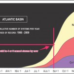
So, how has the Atlantic hurricane season shaping up so far?
According to data accumulated by the National Weather Service, as shown (with added items) here ...
... we should have had about four or five named storms at this point in the season. Since numbers for this time of year are small, variation is large, so this is not too meaningful but it can give us an idea.
So far, we have had these storms in the Atlantic:
Tropical Storm ANDREA
Tropical Storm BARRY
Tropical Storm CHANTAL
Tropical Storm DORIAN
Tropical Storm ERIN
The next storm will be named Fernand, and it may be forming as we…
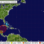
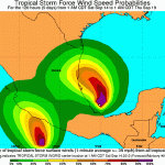
There are at present two systems in the Atlantic that have a good chance of producing tropical storms and possibly, eventually, hurricanes. One is east of the Yucatan, the other is very near the coast of West Africa.
Here's the report from the National Weather Service. I've used a rough routine to convert case so it is not screaming at you (the NWS has not yet implemented the rumored policy of not using ALL CAPS FOR EVERYTHING.
1. The broad area of low pressure in the northwestern caribbean sea is moving toward the west-northwest at 10 to 15 mph. Cloudiness and showers associated with…

Dorian is a tropical storm that formed in the eastern tropical Atlantic ago. Dorian is probably going to head almost straight west-northwest and menace the vicinity north of the Greater Antilles and the Bahamas. This is going to take some time. By the end of the weekend, Dorian will be encountering islands in the northeastern Caribbean as a topical storm, most likely. The chance of Dorian remaining as a storm (as opposed to regressing to a depression) or strengthening from storm to hurricane is not at all large. But, unlike some others storms we've seen lately, Dorian seems to gain a little…
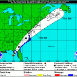
The first named storm of the Atlantic hurricane season has developed. Tropical Storm Andrea formed over the last several hours, and now exhibits winds of 63 knots at 5000 feet, with a surface intensity of about 50 knots, though these winds are only found in the "right hand" side of the storm, now sitting in the northeastern Gulf of Mexico. Most likely, this is all Andrea is going to manage as the storm moves north to make landfall, where it will also interact with upper level winds which will convert the storm to a big rain storm over the next day and a half. However, Andrea will be a very…

Probably.
The Tropical Meteorology Project at Colorado State University makes annual predictions of hurricane season activity, and they released one of these predictions today. This particular group has a good track record, although I would worry that they tenaciously hold to the idea that global warming is not a factor in hurricane development despite the fact that some of the factors (a disrupted ENSO and high SST) that are most affected in the Atlantic by global warming actually drive their predictions. Still, their predictions seem to be based on good empirical data and are probably…
Climate Denial Crock of the Week gives us this new video. Details here.
We are not yet where we need to be with this "when did you stop beating your wife" question sometimes in the form of:
"Can you REALLY attribute ANY storm to Global Warming, really? No? Then is global warming really real? Really?")
Next time someone says something like that to you, consider answering the question with a question:
"Which major storm of the last two decades or so did not include any of the extra climatic energy provided to this planet by the release of fossil Carbon and other greenhouse gasses into…
Earlier this year a paper was published in the journal Nature in which a team of scientists looked at changes in storm surge potential under conditions of global warming, and they used the New York City area in their modeling. Combined with resent research adding to the growing body of data and studies that show increased storminess with global warming, this research suggests that the increased possibility of a hurricane causing a storm surge that would actually flood the subways in Manhattan is not only possible, but pretty likely to happen in the near future. Perhaps as soon as ....…
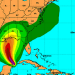
If you are in the path...the thousand mile wide path...of Hurricane Sandy, a.k.a. Frankenstorm, then you should make sure you know what the storm could do in relationship to where you are. If you are in or near an area with mountains, look for very serious flash flooding. The winds will be strong everywhere. If you are near the coast, be aware that the highest storm surges seen in years are expected in many areas. At the same time, it is important for those of us writing or talking about this storm to be realistic and careful in making predictions. This is becasue every case of dire…
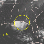
[Update Update: The probability of ex-Isaac becoming a tropical cyclone is now 50%, and the storm is looking pretty good.]
[Update: The probability of this low pressure system turing into a tropical storm has been increased to 40%. It is moving in the general direction of some relatively warm water.]
Hurricane Isaac was supposed to move, as a tropical storm then as an extratropical low, up the Mississippi, then east across the middle of the US. However, the low pressure system that was once Isaac has instead started to move back south again, and it is now a low pressure system of interest…
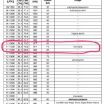
This isn't even in the advisories and discussions yet on the Hurricane Center site, but they are calling Isaac a hurricane. Here's a recent snapshot:
Hurricane Isaac
The current track puts Isaac just southwest of New Orleans with the heaviest winds and storm surge along the outer reaches of the delta and Lake Pontchartrain.
Expect a storm surge in Southeastern Louisiana and Mississippi east of where the landfall occurs of 6-12 feet, with diminishing storm surge reaching as far as the Florida West Coast. Rainfall will be between 7 and 14 inches across a large area, with isolated areas…